Bridge Statistics for Suisun City, California (CA)
Condition, Traffic, Stress, Structural Evaluation, Project Costs
- National Bridge Inventory (NBI) Statistics
- 17Number of bridges
- 167ft / 51.1mTotal length
- 187,554Total average daily traffic
- 11,439Total average daily truck traffic
- National Bridge Inventory (NBI) Registered Bridges for Suisun City
- No street view available for this location
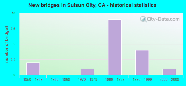
- New bridges - historical statistics
- 21950-1959
- 11970-1979
- 91980-1989
- 41990-1999
- 12000-2009


- Bridge Condition - Deck
- 50.0%Good
- 33.3%Satisfactory
- 16.7%Fair

- Bridge Condition - Superstructure
- 50.0%Good
- 16.7%Satisfactory
- 33.3%Fair

- Bridge Condition - Channel
- 25.0%Excellent
- 50.0%Very good
- 12.5%Good
- 12.5%Satisfactory

- Bridge Condition - Culverts
- 66.7%Good
- 16.7%Satisfactory
- 16.7%Fair
Find on map >> Show street view
Structure Number: 23 0017, Location: 04-SOL-012-6.28-SUIS (Lat: 38.243192, Lng: -122.011058), Route carried "on" structure: State highway 12, Year Built: 1988, Year Reconstructed: 1996, Status: Open, Structure Length: 3.87m (12.70ft), Average Daily Traffic: 36,000 (year 2009), Truck Traffic: 7%, Average Future Daily Traffic: 63,701 (year 2042), Design Load: HS 20+Mod, Features Intersected: MCCOY CREEK
Minimum Vertical Clearance: 30+ m (98+ ft), Kilometerpoint: 6.280, Lanes on structure: 4, Base Highway Network: Yes (, Subroute: 1), Owner: State Highway Agency, Approaching Roadway Width: 23.8m (78.1ft), Skew: 23 degrees, Material/Design: Concrete continuous, Design/Construction: Culvert, Number Of Spans In Main Unit: 10, Length of Maximum Span: 3.0m (9.8ft), Curb-To-Curb Width: 23.8m (78.1ft), Out-to-Out Width: 38.3m (125.7ft)
Condition: Channel: Very good, Culverts: Fair, Operating Rating: 54.1 metric tons, Method Used To Determine Operating Rating: Field evaluation and documented engineering judgment, Inventory Rating: 32.4 metric tons, Method Used To Determine Inventory Rating: Field evaluation and documented engineering judgment, Structural Evaluation: Somewhat better than minimum adequacy, Deck Geometry: Superior to present desirable criteria, Waterway Adequacy: Equal to present desirable criteria, Approach Roadway Alignment: Equal to present desirable criteria, Designated Inspection Frequency: Every 24 months, Inspection Date: March 2020, Deck Structure Type: Concrete Cast-file-Place, Wearing Surface/Protective System: Wearing Surface: Bituminous
Find on map >> Show street view
Structure Number: 23 0134, Location: 04-SOL-012-8.54 (Lat: 38.229647, Lng: -121.976314), Route carried "on" structure: State highway 12, Year Built: 1957, Status: Open, Structure Length: 2.20m (7.22ft), Average Daily Traffic: 12,200 (year 2009), Truck Traffic: 7%, Average Future Daily Traffic: 19,868 (year 2042), Design Load: HS 20, Features Intersected: UNION CREEK
Minimum Vertical Clearance: 30+ m (98+ ft), Kilometerpoint: 8.540, Lanes on structure: 2, Base Highway Network: Yes (, Subroute: 1), Owner: State Highway Agency, Approaching Roadway Width: 11.9m (39.0ft), Skew: 33 degrees, Material/Design: Concrete continuous, Design/Construction: Slab, Number Of Spans In Main Unit: 3, Length of Maximum Span: 8.6m (28.2ft), Curb-To-Curb Width: 12.2m (40.0ft), Out-to-Out Width: 12.3m (40.4ft)
Condition: Deck: Satisfactory, Superstructure: Satisfactory, Substructure: Good, Channel: Very good, Operating Rating: 54.1 metric tons, Method Used To Determine Operating Rating: Load and Resistance Factor Rating (LRFR) rating reported by rating factor(RF) method using HL-93 loadings, Inventory Rating: 41.8 metric tons, Method Used To Determine Inventory Rating: Load and Resistance Factor Rating (LRFR) rating reported by rating factor(RF) method using HL-93 loadings, Structural Evaluation: Equal to present minimum criteria, Deck Geometry: Somewhat better than minimum adequacy, Waterway Adequacy: Equal to present minimum criteria, Approach Roadway Alignment: Equal to present desirable criteria, Designated Inspection Frequency: Every 24 months, Inspection Date: March 2020, Deck Structure Type: Concrete Cast-file-Place, Wearing Surface/Protective System: Wearing Surface: Bituminous
Find on map >> Show street view
Structure Number: 23 0195, Location: 04-SOL-080-41.30 (Lat: 38.505508, Lng: -121.786122), Route carried "on" structure: County highway , Year Built: 1992, Status: Open, Structure Length: 7.44m (24.41ft), Average Daily Traffic: 740 (year 1998), Truck Traffic: 5%, Average Future Daily Traffic: 1,041 (year 2042), Design Load: HS 20+Mod, Features Intersected: INTERSTATE 80, Facility Carried by Structure: KIDWELL ROAD
Minimum Vertical Clearance: 30+ m (98+ ft), Kilometerpoint: 0.000, Lanes on structure: 2, Lanes under structure: 8, Owner: State Highway Agency, Approaching Roadway Width: 12.5m (41.0ft), Skew: 1 degrees, Material/Design: Prestressed concrete continuous, Design/Construction: Box Beam or Girders - Multiple, Number Of Spans In Main Unit: 2, Length of Maximum Span: 36.8m (120.7ft), Curb-To-Curb Width: 12.2m (40.0ft), Out-to-Out Width: 13.3m (43.6ft)
Condition: Deck: Good, Superstructure: Good, Substructure: Good, Operating Rating: 54.1 metric tons, Method Used To Determine Operating Rating: Assigned rating based on Load Factor Design (LFD) reported in metric tons, Inventory Rating: 32.4 metric tons, Method Used To Determine Inventory Rating: Assigned rating based on Load Factor Design (LFD) reported in metric tons, Structural Evaluation: Better than present minimum criteria, Deck Geometry: Equal to present desirable criteria, Underclear: Equal to present minimum criteria, Approach Roadway Alignment: Equal to present desirable criteria, Designated Inspection Frequency: Every 24 months, Inspection Date: November 2020, Deck Structure Type: Concrete Cast-file-Place
Find on map >> Show street view
Structure Number: 23 0196, Location: 04-SOL-012-R4.57-SUIS (Lat: 38.243364, Lng: -122.041953), Route carried "on" structure: State highway 12, Year Built: 1984, Status: Open, Structure Length: 16.00m (52.49ft), Average Daily Traffic: 44,000 (year 2009), Truck Traffic: 7%, Average Future Daily Traffic: 69,232 (year 2040), Design Load: HS 20, Features Intersected: UP RR,BNSF, AMTRAK, MAIN
Minimum Vertical Clearance: 30+ m (98+ ft), Kilometerpoint: 4.570, Lanes on structure: 6, Lanes under structure: 2, Base Highway Network: Yes (, Subroute: 1), Owner: State Highway Agency, Approaching Roadway Width: 28.7m (94.2ft), Skew: 33 degrees, Material/Design: Prestressed concrete continuous, Design/Construction: Box Beam or Girders - Multiple, Number Of Spans In Main Unit: 4, Length of Maximum Span: 47.2m (154.9ft), Curb-To-Curb Width: 26.2m (86.0ft), Out-to-Out Width: 27.3m (89.6ft)
Condition: Deck: Satisfactory, Superstructure: Good, Substructure: Good, Operating Rating: 54.1 metric tons, Method Used To Determine Operating Rating: Assigned rating based on Load Factor Design (LFD) reported in metric tons, Inventory Rating: 32.4 metric tons, Method Used To Determine Inventory Rating: Assigned rating based on Load Factor Design (LFD) reported in metric tons, Structural Evaluation: Better than present minimum criteria, Deck Geometry: Meets minimum limits, Underclear: Meets minimum limits, Approach Roadway Alignment: Equal to present desirable criteria, Designated Inspection Frequency: Every 24 months, Inspection Date: March 2020, Deck Structure Type: Concrete Cast-file-Place
Find on map >> Show street view
Structure Number: 23 0197, Location: 04-SOL-012-R4.47-SUIS (Lat: 38.242917, Lng: -122.043483), Route carried "on" structure: State highway 12, Year Built: 1984, Status: Open, Structure Length: 4.31m (14.14ft), Average Daily Traffic: 44,000 (year 2009), Truck Traffic: 7%, Average Future Daily Traffic: 69,232 (year 2040), Design Load: HS 20+Mod, Features Intersected: WEBSTER STREET ON & OFF
Minimum Vertical Clearance: 30+ m (98+ ft), Kilometerpoint: 4.470, Lanes on structure: 5, Lanes under structure: 2, Base Highway Network: Yes (, Subroute: 1), Owner: State Highway Agency, Approaching Roadway Width: 28.7m (94.2ft), Skew: 33 degrees, Material/Design: Prestressed concrete, Design/Construction: Box Beam or Girders - Multiple, Number Of Spans In Main Unit: 1, Length of Maximum Span: 42.7m (140.1ft), Curb-To-Curb Width: 25.6m (84.0ft), Out-to-Out Width: 26.7m (87.6ft)
Condition: Deck: Fair, Superstructure: Fair, Substructure: Good, Operating Rating: 54.1 metric tons, Method Used To Determine Operating Rating: Assigned rating based on Load Factor Design (LFD) reported in metric tons, Inventory Rating: 32.4 metric tons, Method Used To Determine Inventory Rating: Assigned rating based on Load Factor Design (LFD) reported in metric tons, Structural Evaluation: Somewhat better than minimum adequacy, Deck Geometry: Better than present minimum criteria, Underclear: Equal to present minimum criteria, Approach Roadway Alignment: Equal to present desirable criteria, Designated Inspection Frequency: Every 24 months, Inspection Date: March 2020, Deck Structure Type: Concrete Cast-file-Place
Find on map >> Show street view
Structure Number: 23 0197K, Location: 04-SOL-012-R4.47-SUIS (Lat: 38.243231, Lng: -122.043483), Route carried "on" structure: Ramp State highway 12, Year Built: 1984, Status: Open, Structure Length: 4.17m (13.68ft), Average Daily Traffic: 2,000 (year 2011), Truck Traffic: 2%, Average Future Daily Traffic: 7,651 (year 2042), Design Load: HS 20+Mod, Features Intersected: WEBSTER STREET ON & OFF
Minimum Vertical Clearance: 30+ m (98+ ft), Kilometerpoint: 4.470, Lanes on structure: 1, Lanes under structure: 2, Owner: State Highway Agency, Approaching Roadway Width: 9.1m (29.9ft), Skew: 1 degrees, Material/Design: Prestressed concrete, Design/Construction: Box Beam or Girders - Multiple, Number Of Spans In Main Unit: 1, Length of Maximum Span: 41.7m (136.8ft), Curb-To-Curb Width: 7.3m (24.0ft), Out-to-Out Width: 8.4m (27.6ft)
Condition: Deck: Good, Superstructure: Fair, Substructure: Good, Operating Rating: 54.1 metric tons, Method Used To Determine Operating Rating: Assigned rating based on Load Factor Design (LFD) reported in metric tons, Inventory Rating: 32.4 metric tons, Method Used To Determine Inventory Rating: Assigned rating based on Load Factor Design (LFD) reported in metric tons, Structural Evaluation: Somewhat better than minimum adequacy, Deck Geometry: Better than present minimum criteria, Underclear: High priority of corrective action, Approach Roadway Alignment: Equal to present desirable criteria, Designated Inspection Frequency: Every 24 months, Inspection Date: March 2020, Deck Structure Type: Concrete Cast-file-Place
Find on map >> Show street view
Structure Number: 23C0081, Location: 0.2 MI E OF PENN AVE (Lat: 38.235806, Lng: -122.050736), Route carried "on" structure: City street , Year Built: 1950, Status: Open, Structure Length: 1.52m (4.99ft), Average Daily Traffic: 1,621 (year 2011), Truck Traffic: 5%, Average Future Daily Traffic: 2,968 (year 2042), Features Intersected: PENNSYLVANIA CREEK, Facility Carried by Structure: CORDELIA RD
Minimum Vertical Clearance: 30+ m (98+ ft), Kilometerpoint: 0.000, Lanes on structure: 2, Owner: County Highway Agency, Approaching Roadway Width: 8.2m (26.9ft), Material/Design: Concrete continuous, Design/Construction: Culvert, Number Of Spans In Main Unit: 8, Length of Maximum Span: 2.1m (6.9ft), Curb-To-Curb Width: 12.5m (41.0ft), Out-to-Out Width: 12.7m (41.7ft)
Condition: Channel: Satisfactory, Culverts: Satisfactory, Operating Rating: 40.5 metric tons, Method Used To Determine Operating Rating: Field evaluation and documented engineering judgment, Inventory Rating: 24.3 metric tons, Method Used To Determine Inventory Rating: Field evaluation and documented engineering judgment, Structural Evaluation: Equal to present minimum criteria, Deck Geometry: Better than present minimum criteria, Waterway Adequacy: Equal to present minimum criteria, Approach Roadway Alignment: Equal to present desirable criteria, Designated Inspection Frequency: Every 24 months, Inspection Date: August 2020, Deck Structure Type: Concrete Cast-file-Place, Wearing Surface/Protective System: Wearing Surface: Bituminous
Find on map >> Show street view
Structure Number: 23C0232, Location: 0.01 MI S OF RAILROAD AVE (Lat: 38.253453, Lng: -122.019761), Route carried "on" structure: City street , Year Built: 1991, Status: Open, Structure Length: 0.71m (2.33ft), Average Daily Traffic: 22,651 (year 2010), Truck Traffic: 3%, Average Future Daily Traffic: 32,929 (year 2043), Features Intersected: LAUREL CREEK, Facility Carried by Structure: SUNSET AVE
Minimum Vertical Clearance: 30+ m (98+ ft), Kilometerpoint: 0.000, Lanes on structure: 5, Owner: City or Municipal Highway Agency, Approaching Roadway Width: 21.6m (70.9ft), Skew: 30 degrees, Material/Design: Concrete continuous, Design/Construction: Culvert, Number Of Spans In Main Unit: 2, Length of Maximum Span: 3.3m (10.8ft), Curb or Sidewalk Widths: Left: 2.7m (8.9ft), Right: 1.2m (3.9ft), Curb-To-Curb Width: 21.6m (70.9ft), Out-to-Out Width: 27.4m (89.9ft)
Condition: Channel: Very good, Culverts: Good, Operating Rating: 54.1 metric tons, Method Used To Determine Operating Rating: Field evaluation and documented engineering judgment, Inventory Rating: 32.4 metric tons, Method Used To Determine Inventory Rating: Field evaluation and documented engineering judgment, Structural Evaluation: Better than present minimum criteria, Deck Geometry: Somewhat better than minimum adequacy, Waterway Adequacy: Better than present minimum criteria, Approach Roadway Alignment: Equal to present desirable criteria, Designated Inspection Frequency: Every 48 months, Inspection Date: November 2021, Deck Structure Type: Concrete Cast-file-Place, Wearing Surface/Protective System: Wearing Surface: Bituminous
Find on map >> Show street view
Structure Number: 23C0233, Location: 0.5 MI E SUNSET AVE (Lat: 38.253214, Lng: -122.014786), Route carried "on" structure: City street , Year Built: 1991, Status: Open, Structure Length: 2.49m (8.17ft), Average Daily Traffic: 1,500 (year 2010), Truck Traffic: 1%, Average Future Daily Traffic: 3,294 (year 2043), Features Intersected: LAUREL CREEK DIVERSION, Facility Carried by Structure: BLOSSOM AVE
Minimum Vertical Clearance: 30+ m (98+ ft), Kilometerpoint: 0.000, Lanes on structure: 2, Owner: City or Municipal Highway Agency, Approaching Roadway Width: 12.3m (40.4ft), Material/Design: Concrete continuous, Design/Construction: Culvert, Number Of Spans In Main Unit: 6, Length of Maximum Span: 4.0m (13.1ft), Curb or Sidewalk Widths: Left: 1.7m (5.6ft), Right: 2.1m (6.9ft), Curb-To-Curb Width: 12.3m (40.4ft), Out-to-Out Width: 16.8m (55.1ft)
Condition: Channel: Very good, Culverts: Good, Operating Rating: 54.1 metric tons, Method Used To Determine Operating Rating: Field evaluation and documented engineering judgment, Inventory Rating: 32.4 metric tons, Method Used To Determine Inventory Rating: Field evaluation and documented engineering judgment, Structural Evaluation: Better than present minimum criteria, Deck Geometry: Better than present minimum criteria, Waterway Adequacy: Better than present minimum criteria, Approach Roadway Alignment: Equal to present desirable criteria, Designated Inspection Frequency: Every 48 months, Inspection Date: November 2021, Deck Structure Type: Concrete Cast-file-Place, Wearing Surface/Protective System: Wearing Surface: Bituminous
Find on map >> Show street view
Structure Number: 23C0241, Location: 300 FT W SUNSET AVE (Lat: 38.253703, Lng: -122.020697), Route carried "on" structure: City street , Year Built: 1991, Status: Open, Structure Length: 0.70m (2.30ft), Average Daily Traffic: 1,500 (year 2010), Truck Traffic: 1%, Average Future Daily Traffic: 3,294 (year 2043), Features Intersected: LAUREL CREEK DIVERSION, Facility Carried by Structure: RAILROAD AVE
Minimum Vertical Clearance: 30+ m (98+ ft), Kilometerpoint: 0.000, Lanes on structure: 5, Owner: City or Municipal Highway Agency, Approaching Roadway Width: 23.2m (76.1ft), Skew: 31 degrees, Material/Design: Concrete continuous, Design/Construction: Culvert, Number Of Spans In Main Unit: 2, Length of Maximum Span: 3.2m (10.5ft), Curb or Sidewalk Widths: Left: 1.8m (5.9ft), Right: 3.6m (11.8ft), Curb-To-Curb Width: 23.2m (76.1ft), Out-to-Out Width: 30.5m (100.1ft)
Condition: Channel: Good, Culverts: Good, Operating Rating: 54.1 metric tons, Method Used To Determine Operating Rating: Field evaluation and documented engineering judgment, Inventory Rating: 32.4 metric tons, Method Used To Determine Inventory Rating: Field evaluation and documented engineering judgment, Structural Evaluation: Better than present minimum criteria, Deck Geometry: Better than present minimum criteria, Waterway Adequacy: Superior to present desirable criteria, Approach Roadway Alignment: Equal to present desirable criteria, Designated Inspection Frequency: Every 48 months, Inspection Date: November 2021, Deck Structure Type: Concrete Cast-file-Place, Wearing Surface/Protective System: Wearing Surface: Bituminous
Find on map >> Show street view
Structure Number: 23C0262, Location: 1.3 MI S RTE 12 (Lat: 38.225656, Lng: -122.021517), Route carried "on" structure: Spur City street , Year Built: 2009, Status: Open, Structure Length: 5.76m (18.90ft), Average Daily Traffic: 642 (year 2010), Truck Traffic: 2%, Average Future Daily Traffic: 716 (year 2042), Design Load: HS 20+Mod, Features Intersected: HILL SLOUGH, Facility Carried by Structure: GRIZZLEY ISLAND RD
Minimum Vertical Clearance: 30+ m (98+ ft), Kilometerpoint: 0.000, Lanes on structure: 2, Owner: County Highway Agency, Approaching Roadway Width: 10.0m (32.8ft), Material/Design: Prestressed concrete, Design/Construction: Slab, Number Of Spans In Main Unit: 7, Length of Maximum Span: 8.2m (26.9ft), Curb-To-Curb Width: 9.6m (31.5ft), Out-to-Out Width: 9.8m (32.2ft)
Condition: Deck: Good, Superstructure: Good, Substructure: Good, Channel: Excellent, Operating Rating: 54.1 metric tons, Method Used To Determine Operating Rating: Assigned rating based on Load Factor Design (LFD) reported in metric tons, Inventory Rating: 32.4 metric tons, Method Used To Determine Inventory Rating: Assigned rating based on Load Factor Design (LFD) reported in metric tons, Structural Evaluation: Better than present minimum criteria, Deck Geometry: Equal to present minimum criteria, Waterway Adequacy: Equal to present desirable criteria, Approach Roadway Alignment: Equal to present desirable criteria, Designated Inspection Frequency: Every 48 months, Underwater Inspection Frequency: Every 60 months, Inspection Date: August 2020, Underwater Inspection Date: Febuary 2020, Deck Structure Type: Concrete Cast-file-Place, Wearing Surface/Protective System: Wearing Surface: Monolithic Concrete
Find on map >> Show street view
Structure Number: 23C0281, Location: 0.5 MI E OF SUNSET AVE (Lat: 38.248439, Lng: -122.006525), Route carried "on" structure: Spur City street , Year Built: 1979, Status: Open, Structure Length: 1.97m (6.46ft), Average Daily Traffic: 300 (year 2012), Truck Traffic: 2%, Average Future Daily Traffic: 536 (year 2043), Features Intersected: MCCOY CREEK, Facility Carried by Structure: PIINTAIL DRIVE
Minimum Vertical Clearance: 30+ m (98+ ft), Kilometerpoint: 0.000, Lanes on structure: 2, Owner: City or Municipal Highway Agency, Approaching Roadway Width: 12.2m (40.0ft), Material/Design: Concrete continuous, Design/Construction: Culvert, Number Of Spans In Main Unit: 6, Length of Maximum Span: 3.0m (9.8ft), Curb or Sidewalk Widths: Left: 1.5m (4.9ft), Right: 1.5m (4.9ft), Curb-To-Curb Width: 12.2m (40.0ft), Out-to-Out Width: 15.8m (51.8ft)
Condition: Channel: Excellent, Culverts: Good, Operating Rating: 54.1 metric tons, Method Used To Determine Operating Rating: Field evaluation and documented engineering judgment, Inventory Rating: 32.4 metric tons, Method Used To Determine Inventory Rating: Field evaluation and documented engineering judgment, Structural Evaluation: Better than present minimum criteria, Deck Geometry: Superior to present desirable criteria, Waterway Adequacy: Better than present minimum criteria, Approach Roadway Alignment: Equal to present desirable criteria, Designated Inspection Frequency: Every 48 months, Inspection Date: November 2021, Deck Structure Type: Concrete Cast-file-Place, Wearing Surface/Protective System: Wearing Surface: Bituminous
Find on map >> Show street view
Structure Number: 23 0196, Location: 04-SOL-012-R4.57-SUIS (Lat: 38.243364, Lng: -122.041953), Route carried "under" structure: City street , Year Built: 1984, Structure Length: 0. m, Average Daily Traffic: 12,800 (year 2011), Truck Traffic: 5%, Features Intersected: UP RR,BNSF, AMTRAK, MAIN, Facility Carried by Structure: STATE ROUTE 12
Minimum Vertical Clearance: 7.54m (24.74ft), Kilometerpoint: 0.000, Lanes on structure: 6, Lanes under structure: 2, Material/Design: Prestressed concrete continuous, Design/Construction: Box Beam or Girders - Multiple, Length of Maximum Span: 47.2m (154.9ft)
Find on map >> Show street view
Structure Number: 23 0197, Location: 04-SOL-012-R4.47-SUIS (Lat: 38.242917, Lng: -122.043483), Route carried "under" structure: Ramp State highway 12, Year Built: 1984, Structure Length: 0. m, Average Daily Traffic: 1,500 (year 2011), Truck Traffic: 5%, Features Intersected: WEBSTER STREET ON & OFF
Minimum Vertical Clearance: 5.15m (16.90ft), Kilometerpoint: 4.490, Lanes on structure: 5, Lanes under structure: 1, Material/Design: Prestressed concrete, Design/Construction: Box Beam or Girders - Multiple, Length of Maximum Span: 42.7m (140.1ft)
Find on map >> Show street view
Structure Number: 23 0197, Location: 04-SOL-012-R4.47-SUIS (Lat: 38.242917, Lng: -122.043483), Route carried "under" structure: Ramp State highway 12, Year Built: 1984, Structure Length: 0. m, Average Daily Traffic: 2,300 (year 2011), Truck Traffic: 5%, Features Intersected: WEBSTER STREET ON & OFF
Minimum Vertical Clearance: 5.13m (16.83ft), Kilometerpoint: 4.490, Lanes on structure: 5, Lanes under structure: 1, Material/Design: Prestressed concrete, Design/Construction: Box Beam or Girders - Multiple, Length of Maximum Span: 42.7m (140.1ft)
Find on map >> Show street view
Structure Number: 23 0197K, Location: 04-SOL-012-R4.47-SUIS (Lat: 38.243231, Lng: -122.043483), Route carried "under" structure: Ramp State highway 12, Year Built: 1984, Structure Length: 0. m, Average Daily Traffic: 2,300 (year 2011), Truck Traffic: 5%, Features Intersected: WEBSTER STREET ON & OFF
Minimum Vertical Clearance: 5.13m (16.83ft), Kilometerpoint: 4.490, Lanes on structure: 1, Lanes under structure: 1, Material/Design: Prestressed concrete, Design/Construction: Box Beam or Girders - Multiple, Length of Maximum Span: 41.7m (136.8ft)
Find on map >> Show street view
Structure Number: 23 0197K, Location: 04-SOL-012-R4.47-SUIS (Lat: 38.243231, Lng: -122.043483), Route carried "under" structure: Ramp State highway 12, Year Built: 1984, Structure Length: 0. m, Average Daily Traffic: 1,500 (year 2011), Truck Traffic: 5%, Features Intersected: WEBSTER STREET ON & OFF
Minimum Vertical Clearance: 5.13m (16.83ft), Kilometerpoint: 4.490, Lanes on structure: 1, Lanes under structure: 1, Material/Design: Prestressed concrete, Design/Construction: Box Beam or Girders - Multiple, Length of Maximum Span: 41.7m (136.8ft)