Bridge Statistics for Sun River Terrace, Illinois (IL)
Condition, Traffic, Stress, Structural Evaluation, Project Costs
- National Bridge Inventory (NBI) Statistics
- 16Number of bridges
- 138ft / 42.3mTotal length
- 61,825Total average daily traffic
- 7,781Total average daily truck traffic
- 45,022Total future (year 2032) average daily traffic
- National Bridge Inventory (NBI) Registered Bridges for Sun River Terrace
- No street view available for this location
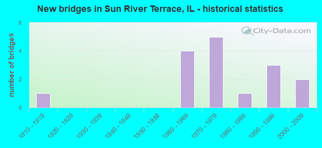
- New bridges - historical statistics
- 11910-1919
- 41960-1969
- 51970-1979
- 11980-1989
- 31990-1999
- 22000-2009

- Reconstructed bridges - Historical Statistics
- 11970-1979
- 01980-1989
- 11990-1999


- Bridge Condition - Deck
- 33.3%Good
- 40.0%Satisfactory
- 26.7%Fair

- Bridge Condition - Superstructure
- 40.0%Good
- 33.3%Satisfactory
- 26.7%Fair

- Bridge Condition - Substructure
- 53.3%Good
- 40.0%Satisfactory
- 6.7%Fair

- Bridge Condition - Channel
- 18.8%Good
- 68.8%Satisfactory
- 12.5%Fair
Find on map >> Show street view
Structure Number: 460037, Location: 3.5 M E OF KANKAKEE (Lat: 41.119289, Lng: -87.769544), Route carried "on" structure: State highway 17, Year Built: 1964, Status: Open, Structure Length: 0.84m (2.76ft), Average Daily Traffic: 11,500 (year 2021), Truck Traffic: 15%, Average Future Daily Traffic: 6,756 (year 2032), Design Load: HS 20, Features Intersected: DRAIN DT
Minimum Vertical Clearance: 30+ m (98+ ft), Kilometerpoint: 302.886, Lanes on structure: 2, Base Highway Network: Yes, Owner: State Highway Agency, Approaching Roadway Width: 11.6m (38.1ft), Skew: 3 degrees, Material/Design: Concrete, Design/Construction: Slab, Number Of Spans In Main Unit: 1, Length of Maximum Span: 8.0m (26.2ft), Curb-To-Curb Width: 12.2m (40.0ft), Out-to-Out Width: 13.0m (42.7ft)
Condition: Deck: Satisfactory, Superstructure: Satisfactory, Substructure: Satisfactory, Channel: Satisfactory, Operating Rating: 66.1 metric tons, Method Used To Determine Operating Rating: Load Factor (LF) rating reported by rating factor (RF) method using MS18 loading, Inventory Rating: 39.9 metric tons, Method Used To Determine Inventory Rating: Load Factor (LF) rating reported by rating factor (RF) method using MS18 loading, Structural Evaluation: Equal to present minimum criteria, Deck Geometry: Better than present minimum criteria, Waterway Adequacy: Equal to present desirable criteria, Approach Roadway Alignment: Equal to present desirable criteria, Designated Inspection Frequency: Every 24 months, Inspection Date: January 2021, Deck Structure Type: Concrete Cast-file-Place, Wearing Surface/Protective System: Wearing Surface: Bituminous
Find on map >> Show street view
Structure Number: 460038, Location: 3.5 M E OF KANKAKEE (Lat: 41.119292, Lng: -87.769353), Route carried "on" structure: State highway 17, Year Built: 1964, Status: Open, Structure Length: 0.84m (2.76ft), Average Daily Traffic: 11,500 (year 2021), Truck Traffic: 15%, Average Future Daily Traffic: 6,756 (year 2032), Design Load: HS 20, Features Intersected: DRAIN DT
Minimum Vertical Clearance: 30+ m (98+ ft), Kilometerpoint: 302.902, Lanes on structure: 2, Base Highway Network: Yes, Owner: State Highway Agency, Approaching Roadway Width: 11.6m (38.1ft), Skew: 3 degrees, Material/Design: Concrete, Design/Construction: Slab, Number Of Spans In Main Unit: 1, Length of Maximum Span: 8.0m (26.2ft), Curb-To-Curb Width: 12.2m (40.0ft), Out-to-Out Width: 13.0m (42.7ft)
Condition: Deck: Satisfactory, Superstructure: Satisfactory, Substructure: Satisfactory, Channel: Good, Operating Rating: 66.1 metric tons, Method Used To Determine Operating Rating: Load Factor (LF) rating reported by rating factor (RF) method using MS18 loading, Inventory Rating: 39.9 metric tons, Method Used To Determine Inventory Rating: Load Factor (LF) rating reported by rating factor (RF) method using MS18 loading, Structural Evaluation: Equal to present minimum criteria, Deck Geometry: Better than present minimum criteria, Waterway Adequacy: Equal to present desirable criteria, Approach Roadway Alignment: Equal to present desirable criteria, Designated Inspection Frequency: Every 24 months, Inspection Date: January 2021, Deck Structure Type: Concrete Cast-file-Place, Wearing Surface/Protective System: Wearing Surface: Bituminous
Find on map >> Show street view
Structure Number: 460039, Location: 4.4 M.E.OF KANKAKEE (Lat: 41.119997, Lng: -87.751464), Route carried "on" structure: State highway 17, Year Built: 1964, Status: Open, Structure Length: 10.41m (34.15ft), Average Daily Traffic: 11,500 (year 2021), Truck Traffic: 15%, Average Future Daily Traffic: 6,756 (year 2032), Design Load: HS 20, Features Intersected: KANKAKEE RIV.
Minimum Vertical Clearance: 30+ m (98+ ft), Kilometerpoint: 304.415, Lanes on structure: 2, Base Highway Network: Yes, Owner: State Highway Agency, Approaching Roadway Width: 11.6m (38.1ft), Skew: 1 degrees, Material/Design: Steel continuous, Design/Construction: Stringer/Multi-beam, Number Of Spans In Main Unit: 4, Length of Maximum Span: 28.5m (93.5ft), Curb-To-Curb Width: 9.1m (29.9ft), Out-to-Out Width: 11.0m (36.1ft)
Condition: Deck: Fair, Superstructure: Fair, Substructure: Satisfactory, Channel: Satisfactory, Operating Rating: 58.3 metric tons, Method Used To Determine Operating Rating: Load Factor (LF) rating reported by rating factor (RF) method using MS18 loading, Inventory Rating: 35.0 metric tons, Method Used To Determine Inventory Rating: Load Factor (LF) rating reported by rating factor (RF) method using MS18 loading, Structural Evaluation: Somewhat better than minimum adequacy, Deck Geometry: Meets minimum limits, Waterway Adequacy: Better than present minimum criteria, Approach Roadway Alignment: Equal to present desirable criteria, Designated Inspection Frequency: Every 24 months, Underwater Inspection Frequency: Every 60 months, Inspection Date: January 2021, Underwater Inspection Date: August 2020, Deck Structure Type: Concrete Cast-file-Place, Wearing Surface/Protective System: Wearing Surface: Latex Concrete
Find on map >> Show street view
Structure Number: 46004, Location: 4.4 M E OF KANKAKEE (Lat: 41.120000, Lng: -87.751275), Route carried "on" structure: State highway 17, Year Built: 1964, Status: Open, Structure Length: 10.41m (34.15ft), Average Daily Traffic: 11,500 (year 2021), Truck Traffic: 15%, Average Future Daily Traffic: 6,756 (year 2032), Design Load: HS 20, Features Intersected: KANKAKEE RIV.
Minimum Vertical Clearance: 30+ m (98+ ft), Kilometerpoint: 304.431, Lanes on structure: 2, Base Highway Network: Yes, Owner: State Highway Agency, Approaching Roadway Width: 11.6m (38.1ft), Skew: 1 degrees, Material/Design: Steel continuous, Design/Construction: Stringer/Multi-beam, Number Of Spans In Main Unit: 4, Length of Maximum Span: 28.5m (93.5ft), Curb-To-Curb Width: 9.1m (29.9ft), Out-to-Out Width: 11.0m (36.1ft)
Condition: Deck: Fair, Superstructure: Fair, Substructure: Satisfactory, Channel: Satisfactory, Operating Rating: 58.3 metric tons, Method Used To Determine Operating Rating: Load Factor (LF) rating reported by rating factor (RF) method using MS18 loading, Inventory Rating: 35.0 metric tons, Method Used To Determine Inventory Rating: Load Factor (LF) rating reported by rating factor (RF) method using MS18 loading, Structural Evaluation: Somewhat better than minimum adequacy, Deck Geometry: Meets minimum limits, Waterway Adequacy: Better than present minimum criteria, Approach Roadway Alignment: Equal to present desirable criteria, Designated Inspection Frequency: Every 24 months, Underwater Inspection Frequency: Every 60 months, Inspection Date: January 2021, Underwater Inspection Date: August 2020, Deck Structure Type: Concrete Cast-file-Place, Wearing Surface/Protective System: Wearing Surface: Latex Concrete
Find on map >> Show street view
Structure Number: 460117, Location: 2.6 MI. S. OF IL 17 (Lat: 41.087642, Lng: -87.723972), Route carried "on" structure: State highway 1, Year Built: 1994, Status: Open, Structure Length: 2.44m (8.01ft), Average Daily Traffic: 3,850 (year 2021), Truck Traffic: 8%, Average Future Daily Traffic: 4,486 (year 2032), Design Load: HS 20, Features Intersected: SPRING CREEK
Minimum Vertical Clearance: 30+ m (98+ ft), Kilometerpoint: 442.622, Lanes on structure: 2, Base Highway Network: Yes, Owner: State Highway Agency, Approaching Roadway Width: 11.0m (36.1ft), Skew: 2 degrees, Material/Design: Concrete continuous, Design/Construction: Slab, Number Of Spans In Main Unit: 3, Length of Maximum Span: 8.5m (27.9ft), Curb-To-Curb Width: 11.0m (36.1ft), Out-to-Out Width: 11.9m (39.0ft)
Condition: Deck: Satisfactory, Superstructure: Satisfactory, Substructure: Good, Channel: Good, Operating Rating: 61.2 metric tons, Method Used To Determine Operating Rating: Load Factor (LF) rating reported by rating factor (RF) method using MS18 loading, Inventory Rating: 36.9 metric tons, Method Used To Determine Inventory Rating: Load Factor (LF) rating reported by rating factor (RF) method using MS18 loading, Structural Evaluation: Equal to present minimum criteria, Deck Geometry: Somewhat better than minimum adequacy, Waterway Adequacy: Equal to present desirable criteria, Approach Roadway Alignment: Equal to present desirable criteria, Designated Inspection Frequency: Every 24 months, Inspection Date: January 2021, Deck Structure Type: Concrete Cast-file-Place, Wearing Surface/Protective System: Deck Protection: Epoxy Coated Reinforcing
Find on map >> Show street view
Structure Number: 460118, Location: 08 MI S. OF IL 17 (Lat: 41.111503, Lng: -87.724408), Route carried "on" structure: State highway 1, Year Built: 1995, Status: Open, Structure Length: 1.31m (4.30ft), Average Daily Traffic: 3,850 (year 2021), Truck Traffic: 8%, Average Future Daily Traffic: 4,486 (year 2032), Design Load: HS 20, Features Intersected: DITCH
Minimum Vertical Clearance: 30+ m (98+ ft), Kilometerpoint: 445.277, Lanes on structure: 2, Base Highway Network: Yes, Owner: State Highway Agency, Approaching Roadway Width: 11.0m (36.1ft), Material/Design: Steel, Design/Construction: Stringer/Multi-beam, Number Of Spans In Main Unit: 1, Length of Maximum Span: 11.6m (38.1ft), Curb-To-Curb Width: 11.0m (36.1ft), Out-to-Out Width: 11.9m (39.0ft)
Condition: Deck: Satisfactory, Superstructure: Good, Substructure: Good, Channel: Good, Operating Rating: 83.9 metric tons, Method Used To Determine Operating Rating: Load Factor (LF) rating reported by rating factor (RF) method using MS18 loading, Inventory Rating: 50.5 metric tons, Method Used To Determine Inventory Rating: Load Factor (LF) rating reported by rating factor (RF) method using MS18 loading, Structural Evaluation: Better than present minimum criteria, Deck Geometry: Somewhat better than minimum adequacy, Waterway Adequacy: Equal to present desirable criteria, Approach Roadway Alignment: Equal to present desirable criteria, Designated Inspection Frequency: Every 48 months, Inspection Date: January 2021, Deck Structure Type: Concrete Cast-file-Place, Wearing Surface/Protective System: Deck Protection: Epoxy Coated Reinforcing
Find on map >> Show street view
Structure Number: 463207, Location: 6.5 MI NO. ST. ANNE (Lat: 41.102642, Lng: -87.709914), Route carried "on" structure: County highway , Year Built: 1910, Year Reconstructed: 1978, Status: Open, Structure Length: 0.73m (2.40ft), Average Daily Traffic: 75 (year 2020), Average Future Daily Traffic: 81 (year 2032), Features Intersected: DRAINAGE DITCH, Facility Carried by Structure: TR 198
Minimum Vertical Clearance: 30+ m (98+ ft), Kilometerpoint: 8.787, Lanes on structure: 2, Owner: Town or Township Highway Agency, Approaching Roadway Width: 4.9m (16.1ft), Material/Design: Steel, Design/Construction: Stringer/Multi-beam, Number Of Spans In Main Unit: 1, Length of Maximum Span: 6.7m (22.0ft), Curb-To-Curb Width: 7.1m (23.3ft), Out-to-Out Width: 7.9m (25.9ft)
Condition: Deck: Satisfactory, Superstructure: Satisfactory, Substructure: Satisfactory, Channel: Satisfactory, Operating Rating: 46.0 metric tons, Method Used To Determine Operating Rating: Load Factor (LF) rating reported by rating factor (RF) method using MS18 loading, Inventory Rating: 27.5 metric tons, Method Used To Determine Inventory Rating: Load Factor (LF) rating reported by rating factor (RF) method using MS18 loading, Structural Evaluation: Equal to present minimum criteria, Deck Geometry: Somewhat better than minimum adequacy, Waterway Adequacy: Equal to present minimum criteria, Approach Roadway Alignment: Equal to present desirable criteria, Designated Inspection Frequency: Every 24 months, Inspection Date: June 2020, Deck Structure Type: Concrete Cast-file-Place
Find on map >> Show street view
Structure Number: 463243, Location: 3.5 MI E KANKAKEE (Lat: 41.118489, Lng: -87.756519), Route carried "on" structure: Other road , Year Built: 1970, Year Reconstructed: 1996, Status: Open, Structure Length: 0.97m (3.18ft), Average Daily Traffic: 350 (year 2021), Truck Traffic: 2%, Average Future Daily Traffic: 811 (year 2032), Design Load: HS 20, Features Intersected: UNNAMED CR, Facility Carried by Structure: FAU 6184 CH 42
Minimum Vertical Clearance: 30+ m (98+ ft), Kilometerpoint: 16.447, Lanes on structure: 2, Owner: County Highway Agency, Approaching Roadway Width: 10.4m (34.1ft), Material/Design: Prestressed concrete, Design/Construction: Box Beam or Girders - Multiple, Number Of Spans In Main Unit: 1, Length of Maximum Span: 9.3m (30.5ft), Curb-To-Curb Width: 11.0m (36.1ft), Out-to-Out Width: 11.0m (36.1ft)
Condition: Deck: Good, Superstructure: Good, Substructure: Good, Channel: Satisfactory, Operating Rating: 70.6 metric tons, Method Used To Determine Operating Rating: Load Factor (LF) rating reported by rating factor (RF) method using MS18 loading, Inventory Rating: 30.8 metric tons, Method Used To Determine Inventory Rating: Load Factor (LF) rating reported by rating factor (RF) method using MS18 loading, Structural Evaluation: Better than present minimum criteria, Deck Geometry: Equal to present desirable criteria, Waterway Adequacy: Equal to present minimum criteria, Approach Roadway Alignment: Equal to present desirable criteria, Designated Inspection Frequency: Every 48 months, Inspection Date: May 2018, Deck Structure Type: Concrete Precast Panels, Wearing Surface/Protective System: Wearing Surface: Bituminous, Membrane: Built-up
Find on map >> Show street view
Structure Number: 463279, Location: 5.9 MI E BRADLEY (Lat: 41.149131, Lng: -87.727689), Route carried "on" structure: County highway , Year Built: 1970, Status: Open, Structure Length: 1.16m (3.81ft), Average Daily Traffic: 475 (year 2021), Truck Traffic: 5%, Average Future Daily Traffic: 541 (year 2032), Design Load: HS 20, Features Intersected: FARR CR, Facility Carried by Structure: TR 87A (OLD CH 54)
Minimum Vertical Clearance: 30+ m (98+ ft), Kilometerpoint: 8.980, Lanes on structure: 2, Owner: Town or Township Highway Agency, Approaching Roadway Width: 5.5m (18.0ft), Material/Design: Concrete, Design/Construction: Channel Beam, Number Of Spans In Main Unit: 1, Length of Maximum Span: 10.7m (35.1ft), Curb-To-Curb Width: 7.4m (24.3ft), Out-to-Out Width: 8.1m (26.6ft)
Condition: Deck: Fair, Superstructure: Fair, Substructure: Satisfactory, Channel: Fair, Operating Rating: 57.7 metric tons, Method Used To Determine Operating Rating: Load Factor (LF) rating reported by rating factor (RF) method using MS18 loading, Inventory Rating: 34.7 metric tons, Method Used To Determine Inventory Rating: Load Factor (LF) rating reported by rating factor (RF) method using MS18 loading, Structural Evaluation: Somewhat better than minimum adequacy, Deck Geometry: Meets minimum limits, Waterway Adequacy: Equal to present minimum criteria, Approach Roadway Alignment: Equal to present desirable criteria, Designated Inspection Frequency: Every 24 months, Inspection Date: May 2020, Deck Structure Type: Concrete Precast Panels
Find on map >> Show street view
Structure Number: 463282, Location: 5 MI NE ST. ANNE (Lat: 41.089806, Lng: -87.714367), Route carried "on" structure: County highway , Year Built: 1971, Status: Open, Structure Length: 1.34m (4.40ft), Average Daily Traffic: 50 (year 2021), Truck Traffic: 4%, Average Future Daily Traffic: 189 (year 2032), Design Load: HS 20, Features Intersected: SPRING CREEK, Facility Carried by Structure: TR 192
Minimum Vertical Clearance: 30+ m (98+ ft), Kilometerpoint: 1.223, Lanes on structure: 2, Owner: Town or Township Highway Agency, Approaching Roadway Width: 5.5m (18.0ft), Skew: 2 degrees, Material/Design: Prestressed concrete, Design/Construction: Box Beam or Girders - Multiple, Number Of Spans In Main Unit: 1, Length of Maximum Span: 13.1m (43.0ft), Curb-To-Curb Width: 7.6m (24.9ft), Out-to-Out Width: 8.4m (27.6ft)
Condition: Deck: Good, Superstructure: Good, Substructure: Good, Channel: Satisfactory, Operating Rating: 56.7 metric tons, Method Used To Determine Operating Rating: Load Factor (LF) rating reported by rating factor (RF) method using MS18 loading, Inventory Rating: 34.0 metric tons, Method Used To Determine Inventory Rating: Load Factor (LF) rating reported by rating factor (RF) method using MS18 loading, Structural Evaluation: Better than present minimum criteria, Deck Geometry: Equal to present minimum criteria, Waterway Adequacy: Equal to present minimum criteria, Approach Roadway Alignment: Equal to present desirable criteria, Designated Inspection Frequency: Every 24 months, Inspection Date: June 2020, Deck Structure Type: Concrete Precast Panels
Find on map >> Show street view
Structure Number: 4633, Location: 3.7 MI E BRADLEY (Lat: 41.148714, Lng: -87.770792), Route carried "on" structure: County highway , Year Built: 1971, Status: Open, Structure Length: 2.96m (9.71ft), Average Daily Traffic: 1,350 (year 2021), Truck Traffic: 1%, Average Future Daily Traffic: 1,784 (year 2032), Design Load: HS 20, Features Intersected: EXLINE SLOUGH, Facility Carried by Structure: TR 87A
Minimum Vertical Clearance: 30+ m (98+ ft), Kilometerpoint: 5.359, Lanes on structure: 2, Owner: Town or Township Highway Agency, Approaching Roadway Width: 6.1m (20.0ft), Material/Design: Concrete, Design/Construction: Channel Beam, Number Of Spans In Main Unit: 3, Length of Maximum Span: 9.8m (32.2ft), Curb-To-Curb Width: 7.4m (24.3ft), Out-to-Out Width: 8.1m (26.6ft)
Condition: Deck: Fair, Superstructure: Fair, Substructure: Good, Channel: Satisfactory, Operating Rating: 51.2 metric tons, Method Used To Determine Operating Rating: Load Factor (LF) rating reported by rating factor (RF) method using MS18 loading, Inventory Rating: 30.5 metric tons, Method Used To Determine Inventory Rating: Load Factor (LF) rating reported by rating factor (RF) method using MS18 loading, Structural Evaluation: Somewhat better than minimum adequacy, Deck Geometry: Meets minimum limits, Waterway Adequacy: Equal to present minimum criteria, Approach Roadway Alignment: Equal to present desirable criteria, Designated Inspection Frequency: Every 24 months, Inspection Date: May 2020, Deck Structure Type: Concrete Precast Panels, Wearing Surface/Protective System: Wearing Surface: Bituminous
Find on map >> Show street view
Structure Number: 463338, Location: 2MI NE EXLINE (Lat: 41.171039, Lng: -87.736392), Route carried "on" structure: County highway , Year Built: 1976, Status: Open, Structure Length: 0.67m (2.20ft), Average Daily Traffic: 75 (year 2021), Average Future Daily Traffic: 81 (year 2032), Design Load: HS 20, Features Intersected: FARR CREEK, Facility Carried by Structure: TR 69
Minimum Vertical Clearance: 30+ m (98+ ft), Kilometerpoint: 2.768, Lanes on structure: 2, Owner: Town or Township Highway Agency, Approaching Roadway Width: 4.9m (16.1ft), Material/Design: Steel, Design/Construction: Culvert, Number Of Spans In Main Unit: 2, Length of Maximum Span: 3.0m (9.8ft)
Condition: Channel: Fair, Culverts: Satisfactory, Operating Rating: 35.0 metric tons, Method Used To Determine Operating Rating: Load Factor (LF) rating reported by rating factor (RF) method using MS18 loading, Inventory Rating: 21.1 metric tons, Method Used To Determine Inventory Rating: Load Factor (LF) rating reported by rating factor (RF) method using MS18 loading, Structural Evaluation: Equal to present minimum criteria, Waterway Adequacy: Equal to present minimum criteria, Approach Roadway Alignment: Equal to present desirable criteria, Designated Inspection Frequency: Every 24 months, Inspection Date: May 2020, Deck Structure Type: Concrete Cast-file-Place
Find on map >> Show street view
Structure Number: 463394, Location: .75 MI SW EXLINE (Lat: 41.137714, Lng: -87.777850), Route carried "on" structure: County highway , Year Built: 1986, Status: Open, Structure Length: 2.96m (9.71ft), Average Daily Traffic: 225 (year 2021), Truck Traffic: 11%, Average Future Daily Traffic: 324 (year 2032), Design Load: HS 20, Features Intersected: BAKER CREEK, Facility Carried by Structure: TR 103
Minimum Vertical Clearance: 30+ m (98+ ft), Kilometerpoint: 1.979, Lanes on structure: 2, Owner: Town or Township Highway Agency, Approaching Roadway Width: 4.6m (15.1ft), Skew: 3 degrees, Material/Design: Prestressed concrete, Design/Construction: Box Beam or Girders - Multiple, Number Of Spans In Main Unit: 3, Length of Maximum Span: 9.8m (32.2ft), Curb-To-Curb Width: 7.3m (24.0ft), Out-to-Out Width: 7.3m (24.0ft)
Condition: Deck: Satisfactory, Superstructure: Satisfactory, Substructure: Fair, Channel: Satisfactory, Operating Rating: 44.4 metric tons, Method Used To Determine Operating Rating: Assigned rating based on Load Factor Design (LFD) reported by rating factor (RF) using MS18 loading, Inventory Rating: 32.4 metric tons, Method Used To Determine Inventory Rating: Assigned rating based on Load Factor Design (LFD) reported by rating factor (RF) using MS18 loading, Structural Evaluation: Somewhat better than minimum adequacy, Deck Geometry: Somewhat better than minimum adequacy, Waterway Adequacy: Equal to present minimum criteria, Approach Roadway Alignment: Equal to present desirable criteria, Designated Inspection Frequency: Every 24 months, Inspection Date: May 2020, Deck Structure Type: Concrete Precast Panels, Wearing Surface/Protective System: Wearing Surface: Gravel
Find on map >> Show street view
Structure Number: 463467, Location: 1MI N OF IL 17 (Lat: 41.135075, Lng: -87.730197), Route carried "on" structure: County highway , Year Built: 2002, Status: Open, Structure Length: 1.87m (6.14ft), Average Daily Traffic: 375 (year 2021), Truck Traffic: 3%, Average Future Daily Traffic: 405 (year 2032), Design Load: HS 20, Features Intersected: FARR CREEK, Facility Carried by Structure: FAS 1309 (CH 42)
Minimum Vertical Clearance: 30+ m (98+ ft), Kilometerpoint: 8.465, Lanes on structure: 2, Owner: County Highway Agency, Approaching Roadway Width: 6.7m (22.0ft), Material/Design: Prestressed concrete, Design/Construction: Box Beam or Girders - Multiple, Number Of Spans In Main Unit: 1, Length of Maximum Span: 18.3m (60.0ft), Curb-To-Curb Width: 9.1m (29.9ft), Out-to-Out Width: 9.1m (29.9ft)
Condition: Deck: Good, Superstructure: Good, Substructure: Good, Channel: Satisfactory, Operating Rating: 44.1 metric tons, Method Used To Determine Operating Rating: Assigned rating based on Load Factor Design (LFD) reported by rating factor (RF) using MS18 loading, Inventory Rating: 32.4 metric tons, Method Used To Determine Inventory Rating: Assigned rating based on Load Factor Design (LFD) reported by rating factor (RF) using MS18 loading, Structural Evaluation: Better than present minimum criteria, Deck Geometry: Equal to present minimum criteria, Waterway Adequacy: Somewhat better than minimum adequacy, Approach Roadway Alignment: Equal to present desirable criteria, Designated Inspection Frequency: Every 48 months, Inspection Date: June 2020, Deck Structure Type: Concrete Precast Panels, Wearing Surface/Protective System: Wearing Surface: Bituminous, Membrane: Built-up
Find on map >> Show street view
Structure Number: 463469, Location: 7300E 3000N (Lat: 41.163672, Lng: -87.734917), Route carried "on" structure: County highway , Year Built: 2006, Status: Open, Structure Length: 1.83m (6.00ft), Average Daily Traffic: 3,050 (year 2021), Truck Traffic: 4%, Average Future Daily Traffic: 2,648 (year 2032), Design Load: HS 20, Features Intersected: FARR CREEK, Facility Carried by Structure: FAS 1328 (CH54)
Minimum Vertical Clearance: 30+ m (98+ ft), Kilometerpoint: 6.936, Lanes on structure: 2, Owner: County Highway Agency, Approaching Roadway Width: 11.0m (36.1ft), Material/Design: Prestressed concrete, Design/Construction: Box Beam or Girders - Multiple, Number Of Spans In Main Unit: 1, Length of Maximum Span: 17.8m (58.4ft), Curb-To-Curb Width: 11.0m (36.1ft), Out-to-Out Width: 11.0m (36.1ft)
Condition: Deck: Good, Superstructure: Good, Substructure: Good, Channel: Satisfactory, Operating Rating: 44.1 metric tons, Method Used To Determine Operating Rating: Assigned rating based on Load Factor Design (LFD) reported by rating factor (RF) using MS18 loading, Inventory Rating: 32.4 metric tons, Method Used To Determine Inventory Rating: Assigned rating based on Load Factor Design (LFD) reported by rating factor (RF) using MS18 loading, Structural Evaluation: Better than present minimum criteria, Deck Geometry: Somewhat better than minimum adequacy, Waterway Adequacy: Equal to present minimum criteria, Approach Roadway Alignment: Equal to present desirable criteria, Designated Inspection Frequency: Every 48 months, Inspection Date: May 2018, Deck Structure Type: Concrete Precast Panels, Wearing Surface/Protective System: Wearing Surface: Bituminous, Membrane: Built-up
Find on map >> Show street view
Structure Number: 46347, Location: 4 MI WNW MOMENCE (Lat: 41.178161, Lng: -87.740019), Route carried "on" structure: County highway , Year Built: 1998, Status: Open, Structure Length: 1.54m (5.05ft), Average Daily Traffic: 2,100 (year 2021), Truck Traffic: 3%, Average Future Daily Traffic: 2,162 (year 2032), Design Load: HS 20, Features Intersected: FARR CREEK, Facility Carried by Structure: TR 63 C
Minimum Vertical Clearance: 30+ m (98+ ft), Kilometerpoint: 2.478, Lanes on structure: 2, Owner: Town or Township Highway Agency, Approaching Roadway Width: 6.1m (20.0ft), Material/Design: Prestressed concrete, Design/Construction: Box Beam or Girders - Multiple, Number Of Spans In Main Unit: 1, Length of Maximum Span: 15.0m (49.2ft), Curb-To-Curb Width: 9.1m (29.9ft), Out-to-Out Width: 9.1m (29.9ft)
Condition: Deck: Good, Superstructure: Good, Substructure: Good, Channel: Satisfactory, Operating Rating: 44.1 metric tons, Method Used To Determine Operating Rating: Assigned rating based on Load Factor Design (LFD) reported by rating factor (RF) using MS18 loading, Inventory Rating: 32.4 metric tons, Method Used To Determine Inventory Rating: Assigned rating based on Load Factor Design (LFD) reported by rating factor (RF) using MS18 loading, Structural Evaluation: Better than present minimum criteria, Deck Geometry: Meets minimum limits, Waterway Adequacy: Equal to present minimum criteria, Approach Roadway Alignment: Equal to present desirable criteria, Designated Inspection Frequency: Every 48 months, Inspection Date: May 2018, Deck Structure Type: Concrete Precast Panels, Wearing Surface/Protective System: Wearing Surface: Bituminous, Membrane: Built-up