Bridge Statistics for Vinegar Bend, Alabama (AL)
Condition, Traffic, Stress, Structural Evaluation, Project Costs
- National Bridge Inventory (NBI) Statistics
- 13Number of bridges
- 203ft / 61.6mTotal length
- $17,428,000Total costs
- 15,017Total average daily traffic
- 1,760Total average daily truck traffic
- 20,981Total future (year 2021) average daily traffic
- National Bridge Inventory (NBI) Registered Bridges for Vinegar Bend
- No street view available for this location
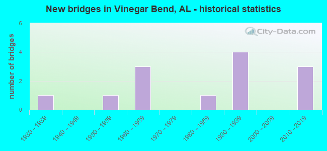
- New bridges - historical statistics
- 11930-1939
- 11950-1959
- 31960-1969
- 11980-1989
- 41990-1999
- 32010-2019


- Bridge Condition - Deck
- 30.0%Very good
- 30.0%Good
- 40.0%Satisfactory

- Bridge Condition - Superstructure
- 20.0%Very good
- 30.0%Good
- 40.0%Satisfactory
- 10.0%Fair

- Bridge Condition - Substructure
- 20.0%Very good
- 30.0%Good
- 30.0%Satisfactory
- 20.0%Poor

- Bridge Condition - Channel
- 30.8%Very good
- 46.2%Good
- 7.7%Satisfactory
- 15.4%Fair

- Bridge Condition - Culverts
- 33.3%Good
- 66.7%Fair
Find on map >> Show street view
Structure Number: 1411, Location: 0.1 MI N JCT US11 * SR68 (Lat: 34.265000, Lng: -85.861667), Route carried "on" structure: US 11, Year Built: 1936, Status: Open, Structure Length: 2.04m (6.69ft), Average Daily Traffic: 7,403 (year 2018), Truck Traffic: 8%, Average Future Daily Traffic: 10,364 (year 2038), Design Load: H 15, Features Intersected: LITTLE WILLS CREEK
Minimum Vertical Clearance: 30+ m (98+ ft), Kilometerpoint: 344.169, Lanes on structure: 2, Owner: State Highway Agency, Approaching Roadway Width: 9.8m (32.2ft), Material/Design: Concrete continuous, Design/Construction: Slab, Number Of Spans In Main Unit: 3, Length of Maximum Span: 7.6m (24.9ft), Curb or Sidewalk Widths: Left: 0.2m (0.7ft), Right: 0.2m (0.7ft), Curb-To-Curb Width: 7.3m (24.0ft), Out-to-Out Width: 8.4m (27.6ft)
Condition: Deck: Satisfactory, Superstructure: Satisfactory, Substructure: Satisfactory, Channel: Satisfactory, Operating Rating: 53.8 metric tons, Method Used To Determine Operating Rating: Load Factor (LF), Inventory Rating: 32.2 metric tons, Method Used To Determine Inventory Rating: Load Factor (LF), Structural Evaluation: Equal to present minimum criteria, Deck Geometry: High priority of replacement, Waterway Adequacy: Equal to present minimum criteria, Approach Roadway Alignment: Equal to present desirable criteria, Length Of Structure Improvement: 2.80m (9.19ft), Designated Inspection Frequency: Every 24 months, Inspection Date: May 2020, Bridge Improvement Cost: $518,000, Roadway Improvement Cost: $52,000, Total Project Cost: $570,000 ( Estimate for 2022)
Find on map >> Show street view
Structure Number: 7936, Location: BURBANK (Lat: 31.216731, Lng: -88.360331), Route carried "on" structure: County highway 8, Year Built: 1963, Status: Open, Structure Length: 2.28m (7.48ft), Average Daily Traffic: 818 (year 2013), Truck Traffic: 12%, Average Future Daily Traffic: 1,216 (year 2041), Design Load: HS 20, Features Intersected: LITTLE CREEK
Minimum Vertical Clearance: 30+ m (98+ ft), Kilometerpoint: 0.010, Lanes on structure: 2, Owner: County Highway Agency, Approaching Roadway Width: 8.5m (27.9ft), Material/Design: Concrete, Design/Construction: Culvert, Number Of Spans In Main Unit: 7, Length of Maximum Span: 3.0m (9.8ft)
Condition: Channel: Good, Culverts: Fair, Operating Rating: 50.0 metric tons, Method Used To Determine Operating Rating: Load Factor (LF), Inventory Rating: 29.9 metric tons, Method Used To Determine Inventory Rating: Load Factor (LF), Structural Evaluation: Somewhat better than minimum adequacy, Waterway Adequacy: Superior to present desirable criteria, Approach Roadway Alignment: Equal to present desirable criteria, Length Of Structure Improvement: 3.10m (10.17ft), Designated Inspection Frequency: Every 24 months, Inspection Date: November 2021, Bridge Improvement Cost: $537,000, Roadway Improvement Cost: $54,000, Total Project Cost: $591,000 ( Estimate for 2022)
Find on map >> Show street view
Structure Number: 13992, Location: 1 MILE NO OF HWY 20 (Lat: 33.403269, Lng: -87.899978), Route carried "on" structure: County highway 121, Year Built: 1986, Status: Posted for load, Structure Length: 0.94m (3.08ft), Average Daily Traffic: 40 (year 1998), Average Future Daily Traffic: 50 (year 2034), Design Load: HS 15, Features Intersected: BEAR CREEK BRANCH
Minimum Vertical Clearance: 30+ m (98+ ft), Kilometerpoint: 0.010, Lanes on structure: 2, Owner: County Highway Agency, Approaching Roadway Width: 8.5m (27.9ft), Material/Design: Wood or Timber, Design/Construction: Stringer/Multi-beam, Number Of Spans In Main Unit: 2, Length of Maximum Span: 4.6m (15.1ft), Curb-To-Curb Width: 6.9m (22.6ft), Out-to-Out Width: 7.3m (24.0ft)
Condition: Deck: Satisfactory, Superstructure: Satisfactory, Substructure: Poor, Channel: Fair, Operating Rating: 4.5 metric tons, Method Used To Determine Operating Rating: Allowable Stress (AS), Inventory Rating: 2.7 metric tons, Method Used To Determine Inventory Rating: Allowable Stress (AS), Structural Evaluation: High priority of replacement, Deck Geometry: Somewhat better than minimum adequacy, Waterway Adequacy: Better than present minimum criteria, Approach Roadway Alignment: Equal to present minimum criteria, Bridge Posting: Required (Relationship of Operating Rating to Maximum Legal Load: > 39.9% below), Length Of Structure Improvement: 1.61m (5.28ft), Designated Inspection Frequency: Every 24 months, Other Special Inspection Frequency: Every 3 months, Inspection Date: January 2021, Other Special Inspection Date: January 2022, Bridge Improvement Cost: $265,000, Roadway Improvement Cost: $27,000, Total Project Cost: $292,000 ( Estimate for 2022), Deck Structure Type: Concrete Cast-file-Place
Find on map >> Show street view
Structure Number: 14109, Location: 1.5 MILE EAST AL 5 (Lat: 32.531544, Lng: -87.329378), Route carried "on" structure: County highway 159, Year Built: 1964, Year Reconstructed: 1987, Status: Posted for load, Structure Length: 1.65m (5.41ft), Average Daily Traffic: 75 (year 1993), Average Future Daily Traffic: 75 (year 2033), Design Load: HS 20, Features Intersected: BOGUECHITTO CREEK
Minimum Vertical Clearance: 30+ m (98+ ft), Kilometerpoint: 0.010, Lanes on structure: 2, Owner: County Highway Agency, Approaching Roadway Width: 8.5m (27.9ft), Material/Design: Steel continuous, Design/Construction: Stringer/Multi-beam, Number Of Spans In Main Unit: 2, Length of Maximum Span: 8.2m (26.9ft), Curb-To-Curb Width: 4.8m (15.7ft), Out-to-Out Width: 5.1m (16.7ft)
Condition: Deck: Good, Superstructure: Satisfactory, Substructure: Poor, Channel: Fair, Operating Rating: 2.7 metric tons, Method Used To Determine Operating Rating: Load Factor (LF), Inventory Rating: 1.8 metric tons, Method Used To Determine Inventory Rating: Load Factor (LF), Structural Evaluation: High priority of replacement, Waterway Adequacy: Meets minimum limits, Approach Roadway Alignment: Equal to present minimum criteria, Bridge Posting: Required (Relationship of Operating Rating to Maximum Legal Load: > 39.9% below), Length Of Structure Improvement: 2.34m (7.68ft), Designated Inspection Frequency: Every 24 months, Other Special Inspection Frequency: Every 12 months, Inspection Date: December 2021, Other Special Inspection Date: November 2021, Bridge Improvement Cost: $257,000, Roadway Improvement Cost: $26,000, Total Project Cost: $283,000 ( Estimate for 2022), Deck Structure Type: Concrete Cast-file-Place
Find on map >> Show street view
Structure Number: 14111, Location: 2.7 MI E JCT I 565 & I 65 (Lat: 34.633417, Lng: -86.863083), Route carried "on" structure: ServiceInterstate 565, Year Built: 1965, Year Reconstructed: 1987, Status: Open, Structure Length: 7.32m (24.02ft), Average Daily Traffic: 606 (year 2021), Truck Traffic: 2%, Average Future Daily Traffic: 717 (year 2031), Design Load: HS 20, Features Intersected: LIMESTONE CREEK RELIEF
Minimum Vertical Clearance: 30+ m (98+ ft), Kilometerpoint: 3.697, Lanes on structure: 2, Owner: State Highway Agency, Approaching Roadway Width: 9.8m (32.2ft), Skew: 10 degrees, Material/Design: Concrete, Design/Construction: Tee Beam, Number Of Spans In Main Unit: 7, Length of Maximum Span: 10.4m (34.1ft), Curb-To-Curb Width: 8.5m (27.9ft), Out-to-Out Width: 10.1m (33.1ft)
Condition: Deck: Good, Superstructure: Good, Substructure: Good, Channel: Good, Operating Rating: 43.5 metric tons, Method Used To Determine Operating Rating: Load Factor (LF), Inventory Rating: 26.1 metric tons, Method Used To Determine Inventory Rating: Load Factor (LF), Structural Evaluation: Equal to present minimum criteria, Deck Geometry: Somewhat better than minimum adequacy, Waterway Adequacy: Better than present minimum criteria, Approach Roadway Alignment: Better than present minimum criteria, Length Of Structure Improvement: 8.35m (27.40ft), Designated Inspection Frequency: Every 24 months, Inspection Date: Febuary 2021, Bridge Improvement Cost: $1,889,000, Roadway Improvement Cost: $189,000, Total Project Cost: $2,078,000 ( Estimate for 2022), Deck Structure Type: Concrete Cast-file-Place
Find on map >> Show street view
Structure Number: 16328, Location: 4.1 MI N OF DEER PARK (Lat: 31.265653, Lng: -88.325892), Route carried "on" structure: US 45, Year Built: 1995, Status: Open, Structure Length: 13.47m (44.19ft), Average Daily Traffic: 2,500 (year 2013), Truck Traffic: 20%, Average Future Daily Traffic: 3,380 (year 2033), Design Load: HS 20, Features Intersected: PINE BARREN CREEK
Minimum Vertical Clearance: 30+ m (98+ ft), Kilometerpoint: 3.201, Lanes on structure: 2, Owner: State Highway Agency, Approaching Roadway Width: 12.2m (40.0ft), Material/Design: Prestressed concrete continuous, Design/Construction: Stringer/Multi-beam, Number Of Spans In Main Unit: 13, Length of Maximum Span: 10.4m (34.1ft), Curb-To-Curb Width: 12.2m (40.0ft), Out-to-Out Width: 13.1m (43.0ft)
Condition: Deck: Good, Superstructure: Good, Substructure: Good, Channel: Good, Operating Rating: 57.5 metric tons, Method Used To Determine Operating Rating: Load Factor (LF), Inventory Rating: 34.5 metric tons, Method Used To Determine Inventory Rating: Load Factor (LF), Structural Evaluation: Better than present minimum criteria, Deck Geometry: Equal to present minimum criteria, Waterway Adequacy: Equal to present desirable criteria, Approach Roadway Alignment: Equal to present desirable criteria, Length Of Structure Improvement: 14.28m (46.85ft), Designated Inspection Frequency: Every 24 months, Inspection Date: December 2020, Bridge Improvement Cost: $4,210,000, Roadway Improvement Cost: $421,000, Total Project Cost: $4,631,000 ( Estimate for 2022), Deck Structure Type: Concrete Cast-file-Place
Find on map >> Show street view
Structure Number: 16891, Location: 4.9MI N DEER PARK (Lat: 31.273872, Lng: -88.334081), Route carried "on" structure: US 45, Year Built: 1997, Status: Open, Structure Length: 1.31m (4.30ft), Average Daily Traffic: 2,500 (year 2013), Truck Traffic: 20%, Average Future Daily Traffic: 3,380 (year 2033), Design Load: HS 20, Features Intersected: LITTLE CREEK
Minimum Vertical Clearance: 30+ m (98+ ft), Kilometerpoint: 4.414, Lanes on structure: 2, Owner: State Highway Agency, Approaching Roadway Width: 12.2m (40.0ft), Material/Design: Concrete, Design/Construction: Culvert, Number Of Spans In Main Unit: 4, Length of Maximum Span: 3.0m (9.8ft)
Condition: Channel: Good, Culverts: Good, Operating Rating: 88.9 metric tons, Method Used To Determine Operating Rating: Load Factor (LF), Inventory Rating: 88.9 metric tons, Method Used To Determine Inventory Rating: Load Factor (LF), Structural Evaluation: Better than present minimum criteria, Waterway Adequacy: Better than present minimum criteria, Approach Roadway Alignment: Equal to present desirable criteria, Length Of Structure Improvement: 1.98m (6.50ft), Designated Inspection Frequency: Every 24 months, Inspection Date: January 2021, Bridge Improvement Cost: $688,000, Roadway Improvement Cost: $69,000, Total Project Cost: $757,000 ( Estimate for 2022)
Find on map >> Show street view
Structure Number: 16997, Location: 0.9MI W US 45 (Lat: 31.297492, Lng: -88.378447), Route carried "on" structure: County highway 20, Year Built: 1959, Status: Open, Structure Length: 0.98m (3.22ft), Average Daily Traffic: 200 (year 1997), Truck Traffic: 10%, Average Future Daily Traffic: 200 (year 2034), Design Load: HS 20, Features Intersected: TRIB ESCATAWPA RIVER
Minimum Vertical Clearance: 30+ m (98+ ft), Kilometerpoint: 0.010, Lanes on structure: 2, Owner: County Highway Agency, Approaching Roadway Width: 8.5m (27.9ft), Material/Design: Concrete, Design/Construction: Culvert, Number Of Spans In Main Unit: 3, Length of Maximum Span: 3.0m (9.8ft)
Condition: Channel: Good, Culverts: Fair, Operating Rating: 36.2 metric tons, Method Used To Determine Operating Rating: Load Factor (LF), Inventory Rating: 21.7 metric tons, Method Used To Determine Inventory Rating: Load Factor (LF), Structural Evaluation: Somewhat better than minimum adequacy, Waterway Adequacy: Superior to present desirable criteria, Approach Roadway Alignment: Equal to present desirable criteria, Length Of Structure Improvement: 1.66m (5.45ft), Designated Inspection Frequency: Every 24 months, Inspection Date: May 2020, Bridge Improvement Cost: $287,000, Roadway Improvement Cost: $29,000, Total Project Cost: $316,000 ( Estimate for 2022)
Find on map >> Show street view
Structure Number: 17516, Location: .25MI WEST OF HWY 45 (Lat: 31.266794, Lng: -88.335200), Route carried "on" structure: County highway 1, Year Built: 1998, Status: Open, Structure Length: 4.15m (13.62ft), Average Daily Traffic: 275 (year 1997), Truck Traffic: 2%, Average Future Daily Traffic: 530 (year 2034), Design Load: HS 20, Features Intersected: ESCATAWPA RIVER RELIEF
Minimum Vertical Clearance: 30+ m (98+ ft), Kilometerpoint: 0.000, Lanes on structure: 2, Owner: County Highway Agency, Approaching Roadway Width: 9.6m (31.5ft), Material/Design: Concrete, Design/Construction: Channel Beam, Number Of Spans In Main Unit: 4, Length of Maximum Span: 10.4m (34.1ft), Curb or Sidewalk Widths: Left: 0.4m (1.3ft), Right: 0.4m (1.3ft), Curb-To-Curb Width: 8.5m (27.9ft), Out-to-Out Width: 9.3m (30.5ft)
Condition: Deck: Very good, Superstructure: Good, Substructure: Good, Channel: Very good, Operating Rating: 74.1 metric tons, Method Used To Determine Operating Rating: Load Factor (LF), Inventory Rating: 44.5 metric tons, Method Used To Determine Inventory Rating: Load Factor (LF), Structural Evaluation: Better than present minimum criteria, Deck Geometry: Equal to present minimum criteria, Waterway Adequacy: Superior to present desirable criteria, Approach Roadway Alignment: Equal to present desirable criteria, Length Of Structure Improvement: 5.11m (16.77ft), Designated Inspection Frequency: Every 24 months, Inspection Date: May 2020, Bridge Improvement Cost: $1,051,000, Roadway Improvement Cost: $105,000, Total Project Cost: $1,156,000 ( Estimate for 2022), Deck Structure Type: Concrete Precast Panels
Find on map >> Show street view
Structure Number: 20252, Location: OFF CO.RD.8 NERA MISS LIN (Lat: 31.206494, Lng: -88.427025), Route carried "on" structure: County highway , Year Built: 1998, Status: Posted for load, Structure Length: 0.98m (3.22ft), Average Daily Traffic: 30 (year 2015), Average Future Daily Traffic: 30 (year 2037), Features Intersected: HURRICANE BRANCH, Facility Carried by Structure: LEWIS RD
Minimum Vertical Clearance: 30+ m (98+ ft), Kilometerpoint: 0.000, Lanes on structure: 2, Owner: County Highway Agency, Approaching Roadway Width: 4.9m (16.1ft), Material/Design: Wood or Timber, Design/Construction: Stringer/Multi-beam, Number Of Spans In Main Unit: 2, Length of Maximum Span: 4.9m (16.1ft), Curb-To-Curb Width: 4.9m (16.1ft), Out-to-Out Width: 4.9m (16.1ft)
Condition: Deck: Satisfactory, Superstructure: Satisfactory, Substructure: Satisfactory, Channel: Good, Operating Rating: 15.3 metric tons, Method Used To Determine Operating Rating: Allowable Stress (AS), Inventory Rating: 11.2 metric tons, Method Used To Determine Inventory Rating: Allowable Stress (AS), Structural Evaluation: Meets minimum limits, Waterway Adequacy: Equal to present minimum criteria, Approach Roadway Alignment: Equal to present desirable criteria, Bridge Posting: Required (Relationship of Operating Rating to Maximum Legal Load: > 39.9% below), Length Of Structure Improvement: 1.65m (5.41ft), Designated Inspection Frequency: Every 24 months, Other Special Inspection Frequency: Every 12 months, Inspection Date: July 2021, Other Special Inspection Date: July 2021, Bridge Improvement Cost: $181,000, Roadway Improvement Cost: $18,000, Total Project Cost: $199,000 ( Estimate for 2022), Deck Structure Type: Wood or Timber
Find on map >> Show street view
Structure Number: 20266, Location: VINEGAR BEND (Lat: 31.266053, Lng: -88.337722), Route carried "on" structure: County highway 1, Year Built: 2011, Status: Open, Structure Length: 15.85m (52.00ft), Average Daily Traffic: 240 (year 2010), Truck Traffic: 14%, Average Future Daily Traffic: 360 (year 2041), Design Load: HS 20, Features Intersected: ESCATAWPA RIVER
Minimum Vertical Clearance: 30+ m (98+ ft), Kilometerpoint: 0.000, Lanes on structure: 2, Owner: County Highway Agency, Approaching Roadway Width: 6.1m (20.0ft), Material/Design: Concrete, Design/Construction: Channel Beam, Number Of Spans In Main Unit: 13, Length of Maximum Span: 12.2m (40.0ft), Curb-To-Curb Width: 8.5m (27.9ft), Out-to-Out Width: 9.1m (29.9ft)
Condition: Deck: Very good, Superstructure: Very good, Substructure: Very good, Channel: Very good, Operating Rating: 80.1 metric tons, Method Used To Determine Operating Rating: Load Factor (LF), Inventory Rating: 47.2 metric tons, Method Used To Determine Inventory Rating: Load Factor (LF), Structural Evaluation: Equal to present desirable criteria, Deck Geometry: Equal to present minimum criteria, Waterway Adequacy: Superior to present desirable criteria, Approach Roadway Alignment: Better than present minimum criteria, Length Of Structure Improvement: 16.60m (54.46ft), Designated Inspection Frequency: Every 24 months, Inspection Date: September 2021, Bridge Improvement Cost: $3,416,000, Roadway Improvement Cost: $342,000, Total Project Cost: $3,758,000 ( Estimate for 2022), Deck Structure Type: Concrete Precast Panels
Find on map >> Show street view
Structure Number: 2068, Location: WALLEY BEND (Lat: 31.207375, Lng: -88.412467), Route carried "on" structure: County highway 8, Year Built: 2012, Status: Open, Structure Length: 2.07m (6.79ft), Average Daily Traffic: 160 (year 1992), Average Future Daily Traffic: 400 (year 2041), Design Load: HS 20, Features Intersected: POND CREEK
Minimum Vertical Clearance: 30+ m (98+ ft), Kilometerpoint: 0.000, Lanes on structure: 2, Owner: County Highway Agency, Approaching Roadway Width: 7.3m (24.0ft), Material/Design: Concrete, Design/Construction: Channel Beam, Number Of Spans In Main Unit: 2, Length of Maximum Span: 10.4m (34.1ft), Curb or Sidewalk Widths: Left: 0.4m (1.3ft), Right: 0.4m (1.3ft), Curb-To-Curb Width: 8.5m (27.9ft), Out-to-Out Width: 9.3m (30.5ft)
Condition: Deck: Satisfactory, Superstructure: Fair, Substructure: Satisfactory, Channel: Very good, Operating Rating: 74.1 metric tons, Method Used To Determine Operating Rating: Load Factor (LF), Inventory Rating: 44.5 metric tons, Method Used To Determine Inventory Rating: Load Factor (LF), Structural Evaluation: Somewhat better than minimum adequacy, Deck Geometry: Equal to present minimum criteria, Waterway Adequacy: Equal to present desirable criteria, Approach Roadway Alignment: Equal to present desirable criteria, Length Of Structure Improvement: 2.84m (9.32ft), Designated Inspection Frequency: Every 24 months, Inspection Date: October 2021, Bridge Improvement Cost: $584,000, Roadway Improvement Cost: $58,000, Total Project Cost: $642,000 ( Estimate for 2022), Deck Structure Type: Other
Find on map >> Show street view
Structure Number: 20904, Location: ESCATAWPA (Lat: 31.284081, Lng: -88.391817), Route carried "on" structure: County highway 20, Year Built: 2017, Status: Open, Structure Length: 8.53m (27.99ft), Average Daily Traffic: 170 (year 2016), Average Future Daily Traffic: 279 (year 2021), Design Load: HS 20, Features Intersected: ESCATAWPA RIVER RELIEF
Minimum Vertical Clearance: 30+ m (98+ ft), Kilometerpoint: 0.000, Lanes on structure: 2, Owner: County Highway Agency, Approaching Roadway Width: 8.5m (27.9ft), Material/Design: Concrete, Design/Construction: Stringer/Multi-beam, Number Of Spans In Main Unit: 7, Length of Maximum Span: 12.2m (40.0ft), Curb-To-Curb Width: 8.5m (27.9ft), Out-to-Out Width: 9.4m (30.8ft)
Condition: Deck: Very good, Superstructure: Very good, Substructure: Very good, Channel: Very good, Operating Rating: 67.8 metric tons, Method Used To Determine Operating Rating: Load Factor (LF), Inventory Rating: 40.6 metric tons, Method Used To Determine Inventory Rating: Load Factor (LF), Structural Evaluation: Equal to present desirable criteria, Deck Geometry: Equal to present minimum criteria, Waterway Adequacy: Equal to present desirable criteria, Approach Roadway Alignment: Equal to present desirable criteria, Length Of Structure Improvement: 9.52m (31.23ft), Designated Inspection Frequency: Every 24 months, Inspection Date: May 2021, Bridge Improvement Cost: $1,959,000, Roadway Improvement Cost: $196,000, Total Project Cost: $2,155,000 ( Estimate for 2022), Deck Structure Type: Concrete Cast-file-Place, Wearing Surface/Protective System: Wearing Surface: Integral Concrete