Bridge Statistics for Walls, Mississippi (MS)
Condition, Traffic, Stress, Structural Evaluation, Project Costs
- National Bridge Inventory (NBI) Statistics
- 38Number of bridges
- 528ft / 161mTotal length
- $208,000Total costs
- 153,710Total average daily traffic
- 17,456Total average daily truck traffic
- National Bridge Inventory (NBI) Registered Bridges for Walls
- No street view available for this location
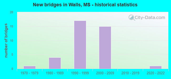
- New bridges - historical statistics
- 11970-1979
- 41980-1989
- 171990-1999
- 152000-2009
- 12020-2022


- Bridge Condition - Deck
- 42.9%Very good
- 42.9%Good
- 14.3%Satisfactory

- Bridge Condition - Superstructure
- 4.8%Excellent
- 33.3%Very good
- 28.6%Good
- 23.8%Satisfactory
- 9.5%Fair

- Bridge Condition - Substructure
- 4.8%Excellent
- 33.3%Very good
- 52.4%Good
- 4.8%Satisfactory
- 4.8%Fair

- Bridge Condition - Channel
- 33.3%Very good
- 42.9%Good
- 23.8%Satisfactory

- Bridge Condition - Culverts
- 20.0%Very good
- 60.0%Good
- 20.0%Satisfactory
Find on map >> Show street view
Structure Number: 21000610173133A, Location: 2.4 MI N TUNICA CL (Lat: 34.884819, Lng: -90.217161), Route carried "on" structure: US 61, Year Built: 1998, Status: Open, Structure Length: 10.76m (35.30ft), Average Daily Traffic: 3,950 (year 2020), Truck Traffic: 16%, Average Future Daily Traffic: 4,200 (year 2040), Design Load: HS 20, Features Intersected: CNIC RR
Minimum Vertical Clearance: 30+ m (98+ ft), Kilometerpoint: 15.234, Lanes on structure: 2, Base Highway Network: Yes (Inventory Route: 6, Subroute: 1), Owner: State Highway Agency, Approaching Roadway Width: 12.8m (42.0ft), Skew: 4 degrees, Material/Design: Prestressed concrete continuous, Design/Construction: Stringer/Multi-beam, Number Of Spans In Main Unit: 1, Number Of Approach Spans: 4, Length of Maximum Span: 24.4m (80.1ft), Curb-To-Curb Width: 12.8m (42.0ft), Out-to-Out Width: 13.7m (44.9ft)
Condition: Deck: Satisfactory, Superstructure: Good, Substructure: Good, Operating Rating: 63.1 metric tons, Method Used To Determine Operating Rating: Load Factor (LF), Inventory Rating: 28.0 metric tons, Method Used To Determine Inventory Rating: Load Factor (LF), Structural Evaluation: Better than present minimum criteria, Deck Geometry: Equal to present desirable criteria, Underclear: Superior to present desirable criteria, Approach Roadway Alignment: Equal to present desirable criteria, Designated Inspection Frequency: Every 24 months, Inspection Date: July 2020, Deck Structure Type: Concrete Cast-file-Place
Find on map >> Show street view
Structure Number: 21000610173136A, Location: 2.7 MI N TUNICA CL (Lat: 34.887953, Lng: -90.213275), Route carried "on" structure: US 61, Year Built: 1998, Status: Open, Structure Length: 10.41m (34.15ft), Average Daily Traffic: 3,950 (year 2020), Truck Traffic: 16%, Average Future Daily Traffic: 4,200 (year 2040), Design Load: HS 20, Features Intersected: LAKE CORMORANT
Minimum Vertical Clearance: 30+ m (98+ ft), Kilometerpoint: 14.738, Lanes on structure: 2, Base Highway Network: Yes (Inventory Route: 6, Subroute: 1), Owner: State Highway Agency, Approaching Roadway Width: 12.8m (42.0ft), Material/Design: Prestressed concrete, Design/Construction: Stringer/Multi-beam, Number Of Spans In Main Unit: 1, Number Of Approach Spans: 7, Length of Maximum Span: 18.3m (60.0ft), Curb-To-Curb Width: 12.8m (42.0ft), Out-to-Out Width: 13.7m (44.9ft)
Condition: Deck: Good, Superstructure: Satisfactory, Substructure: Good, Channel: Good, Operating Rating: 59.9 metric tons, Method Used To Determine Operating Rating: Load Factor (LF), Inventory Rating: 28.8 metric tons, Method Used To Determine Inventory Rating: Load Factor (LF), Structural Evaluation: Equal to present minimum criteria, Deck Geometry: Equal to present desirable criteria, Waterway Adequacy: Equal to present desirable criteria, Approach Roadway Alignment: Equal to present desirable criteria, Designated Inspection Frequency: Every 24 months, Inspection Date: July 2020, Deck Structure Type: Concrete Cast-file-Place
Find on map >> Show street view
Structure Number: 21000610173136B, Location: 2.7 MI N TUNICA CL (Lat: 34.887058, Lng: -90.213958), Route carried "on" structure: US 61, Year Built: 1986, Status: Open, Structure Length: 9.51m (31.20ft), Average Daily Traffic: 3,950 (year 2020), Truck Traffic: 16%, Average Future Daily Traffic: 4,200 (year 2040), Design Load: HS 20, Features Intersected: LAKE CORMORANT
Minimum Vertical Clearance: 30+ m (98+ ft), Kilometerpoint: 4.160, Lanes on structure: 2, Base Highway Network: Yes (Inventory Route: 6, Subroute: 1), Owner: State Highway Agency, Approaching Roadway Width: 12.8m (42.0ft), Material/Design: Prestressed concrete, Design/Construction: Stringer/Multi-beam, Number Of Spans In Main Unit: 1, Number Of Approach Spans: 6, Length of Maximum Span: 21.3m (69.9ft), Curb-To-Curb Width: 12.8m (42.0ft), Out-to-Out Width: 13.7m (44.9ft)
Condition: Deck: Good, Superstructure: Satisfactory, Substructure: Good, Channel: Good, Operating Rating: 52.8 metric tons, Method Used To Determine Operating Rating: Load Factor (LF), Inventory Rating: 27.7 metric tons, Method Used To Determine Inventory Rating: Load Factor (LF), Structural Evaluation: Equal to present minimum criteria, Deck Geometry: Equal to present desirable criteria, Waterway Adequacy: Equal to present desirable criteria, Approach Roadway Alignment: Equal to present desirable criteria, Designated Inspection Frequency: Every 24 months, Inspection Date: June 2020, Deck Structure Type: Concrete Cast-file-Place
Find on map >> Show street view
Structure Number: 21000610173163A, Location: 5.4 MI N TUNICA CL (Lat: 34.916625, Lng: -90.184067), Route carried "on" structure: US 61, Year Built: 1998, Status: Open, Structure Length: 6.10m (20.01ft), Average Daily Traffic: 4,100 (year 2020), Truck Traffic: 18%, Average Future Daily Traffic: 4,350 (year 2040), Design Load: HS 20, Features Intersected: JOHNSON CREEK RELIEF
Minimum Vertical Clearance: 30+ m (98+ ft), Kilometerpoint: 10.578, Lanes on structure: 2, Base Highway Network: Yes (Inventory Route: 6, Subroute: 1), Owner: State Highway Agency, Approaching Roadway Width: 12.8m (42.0ft), Material/Design: Prestressed concrete continuous, Design/Construction: Stringer/Multi-beam, Number Of Spans In Main Unit: 5, Length of Maximum Span: 12.2m (40.0ft), Curb-To-Curb Width: 12.8m (42.0ft), Out-to-Out Width: 13.7m (44.9ft)
Condition: Deck: Good, Superstructure: Fair, Substructure: Very good, Channel: Very good, Operating Rating: 59.9 metric tons, Method Used To Determine Operating Rating: Load Factor (LF), Inventory Rating: 32.2 metric tons, Method Used To Determine Inventory Rating: Load Factor (LF), Structural Evaluation: Somewhat better than minimum adequacy, Deck Geometry: Equal to present desirable criteria, Waterway Adequacy: Equal to present desirable criteria, Approach Roadway Alignment: Equal to present desirable criteria, Designated Inspection Frequency: Every 24 months, Inspection Date: July 2020, Deck Structure Type: Concrete Cast-file-Place
Find on map >> Show street view
Structure Number: 21000610173163B, Location: 5.4 MI N TUNICA CL (Lat: 34.916042, Lng: -90.184214), Route carried "on" structure: US 61, Year Built: 1986, Year Reconstructed: 1996, Status: Open, Structure Length: 6.16m (20.21ft), Average Daily Traffic: 4,100 (year 2020), Truck Traffic: 19%, Average Future Daily Traffic: 4,350 (year 2040), Design Load: HS 20, Features Intersected: JOHNSON CREEK RELIEF
Minimum Vertical Clearance: 30+ m (98+ ft), Kilometerpoint: 8.378, Lanes on structure: 2, Base Highway Network: Yes (Inventory Route: 6, Subroute: 1), Owner: State Highway Agency, Approaching Roadway Width: 12.8m (42.0ft), Material/Design: Prestressed concrete continuous, Design/Construction: Stringer/Multi-beam, Number Of Spans In Main Unit: 5, Length of Maximum Span: 12.2m (40.0ft), Curb-To-Curb Width: 12.8m (42.0ft), Out-to-Out Width: 13.7m (44.9ft)
Condition: Deck: Satisfactory, Superstructure: Satisfactory, Substructure: Good, Channel: Good, Operating Rating: 59.3 metric tons, Method Used To Determine Operating Rating: Load Factor (LF), Inventory Rating: 32.1 metric tons, Method Used To Determine Inventory Rating: Load Factor (LF), Structural Evaluation: Equal to present minimum criteria, Deck Geometry: Equal to present desirable criteria, Waterway Adequacy: Equal to present desirable criteria, Approach Roadway Alignment: Equal to present desirable criteria, Designated Inspection Frequency: Every 24 months, Inspection Date: June 2020, Deck Structure Type: Concrete Cast-file-Place
Find on map >> Show street view
Structure Number: 21000610173165A, Location: 5.6 MI N TUNICA CL (Lat: 34.919072, Lng: -90.181794), Route carried "on" structure: US 61, Year Built: 1998, Status: Open, Structure Length: 5.79m (19.00ft), Average Daily Traffic: 4,100 (year 2020), Truck Traffic: 18%, Average Future Daily Traffic: 4,350 (year 2040), Design Load: HS 20, Features Intersected: JOHNSON CREEK
Minimum Vertical Clearance: 30+ m (98+ ft), Kilometerpoint: 10.235, Lanes on structure: 2, Base Highway Network: Yes (Inventory Route: 6, Subroute: 1), Owner: State Highway Agency, Approaching Roadway Width: 12.8m (42.0ft), Skew: 3 degrees, Material/Design: Prestressed concrete, Design/Construction: Stringer/Multi-beam, Number Of Spans In Main Unit: 1, Number Of Approach Spans: 2, Length of Maximum Span: 27.4m (89.9ft), Curb-To-Curb Width: 12.8m (42.0ft), Out-to-Out Width: 13.7m (44.9ft)
Condition: Deck: Good, Superstructure: Good, Substructure: Good, Channel: Very good, Operating Rating: 53.4 metric tons, Method Used To Determine Operating Rating: Load Factor (LF), Inventory Rating: 24.1 metric tons, Method Used To Determine Inventory Rating: Load Factor (LF), Structural Evaluation: Equal to present minimum criteria, Deck Geometry: Equal to present desirable criteria, Waterway Adequacy: Equal to present desirable criteria, Approach Roadway Alignment: Equal to present desirable criteria, Designated Inspection Frequency: Every 24 months, Inspection Date: July 2020, Deck Structure Type: Concrete Cast-file-Place
Find on map >> Show street view
Structure Number: 21000610173165B, Location: 5.6 MI N TUNICA CL (Lat: 34.918661, Lng: -90.181794), Route carried "on" structure: US 61, Year Built: 1986, Status: Open, Structure Length: 4.94m (16.21ft), Average Daily Traffic: 4,100 (year 2020), Truck Traffic: 19%, Average Future Daily Traffic: 4,350 (year 2040), Design Load: HS 20, Features Intersected: JOHNSON CREEK
Minimum Vertical Clearance: 30+ m (98+ ft), Kilometerpoint: 8.744, Lanes on structure: 2, Base Highway Network: Yes (Inventory Route: 6, Subroute: 1), Owner: State Highway Agency, Approaching Roadway Width: 12.8m (42.0ft), Skew: 4 degrees, Material/Design: Prestressed concrete, Design/Construction: Stringer/Multi-beam, Number Of Spans In Main Unit: 1, Number Of Approach Spans: 2, Length of Maximum Span: 24.4m (80.1ft), Curb-To-Curb Width: 12.8m (42.0ft), Out-to-Out Width: 13.7m (44.9ft)
Condition: Deck: Good, Superstructure: Good, Substructure: Good, Channel: Good, Operating Rating: 38.3 metric tons, Method Used To Determine Operating Rating: Load Factor (LF), Inventory Rating: 34.8 metric tons, Method Used To Determine Inventory Rating: Load Factor (LF), Structural Evaluation: Better than present minimum criteria, Deck Geometry: Equal to present desirable criteria, Waterway Adequacy: Equal to present desirable criteria, Approach Roadway Alignment: Equal to present desirable criteria, Designated Inspection Frequency: Every 24 months, Inspection Date: June 2020, Deck Structure Type: Concrete Cast-file-Place
Find on map >> Show street view
Structure Number: 21000610173203, Location: 0.2 MI S SR 302 (Lat: 34.959128, Lng: -90.141717), Route carried "on" structure: US 61, Year Built: 1997, Status: Open, Structure Length: 0.97m (3.18ft), Average Daily Traffic: 15,000 (year 2020), Truck Traffic: 9%, Average Future Daily Traffic: 15,000 (year 2040), Design Load: HS 20, Features Intersected: STREAM
Minimum Vertical Clearance: 30+ m (98+ ft), Kilometerpoint: 14.687, Lanes on structure: 6, Base Highway Network: Yes (Inventory Route: 6, Subroute: 1), Owner: State Highway Agency, Approaching Roadway Width: 40.8m (133.9ft), Skew: 20 degrees, Material/Design: Concrete, Design/Construction: Culvert, Number Of Spans In Main Unit: 2, Length of Maximum Span: 4.9m (16.1ft)
Condition: Channel: Very good, Culverts: Very good, Operating Rating: 34.0 metric tons, Method Used To Determine Operating Rating: Load Factor (LF), Inventory Rating: 32.4 metric tons, Method Used To Determine Inventory Rating: Load Factor (LF), Structural Evaluation: Equal to present desirable criteria, Waterway Adequacy: Equal to present desirable criteria, Approach Roadway Alignment: Equal to present desirable criteria, Designated Inspection Frequency: Every 24 months, Inspection Date: June 2020
Find on map >> Show street view
Structure Number: 31003010170248, Location: 7.0 MI N SR 304 (Lat: 34.908003, Lng: -90.097539), Route carried "on" structure: State highway 301, Year Built: 1998, Status: Open, Structure Length: 3.71m (12.17ft), Average Daily Traffic: 3,400 (year 2020), Truck Traffic: 10%, Average Future Daily Traffic: 3,600 (year 2040), Design Load: HS 20, Features Intersected: JOHNSON CR TRIB#1 RELIEF
Minimum Vertical Clearance: 30+ m (98+ ft), Kilometerpoint: 20.675, Lanes on structure: 2, Base Highway Network: Yes (Inventory Route: 30, Subroute: 1), Owner: State Highway Agency, Approaching Roadway Width: 13.4m (44.0ft), Skew: 2 degrees, Material/Design: Prestressed concrete continuous, Design/Construction: Stringer/Multi-beam, Number Of Spans In Main Unit: 3, Length of Maximum Span: 12.2m (40.0ft), Curb-To-Curb Width: 13.4m (44.0ft), Out-to-Out Width: 14.3m (46.9ft)
Condition: Deck: Very good, Superstructure: Very good, Substructure: Very good, Channel: Very good, Operating Rating: 61.0 metric tons, Method Used To Determine Operating Rating: Load Factor (LF), Inventory Rating: 36.6 metric tons, Method Used To Determine Inventory Rating: Load Factor (LF), Structural Evaluation: Equal to present desirable criteria, Deck Geometry: Better than present minimum criteria, Waterway Adequacy: Equal to present desirable criteria, Approach Roadway Alignment: Equal to present desirable criteria, Designated Inspection Frequency: Every 48 months, Inspection Date: April 2018, Deck Structure Type: Concrete Cast-file-Place
Find on map >> Show street view
Structure Number: 31003010170249, Location: 7.1 MI N SR 304 (Lat: 34.909164, Lng: -90.096722), Route carried "on" structure: State highway 301, Year Built: 1998, Status: Open, Structure Length: 6.15m (20.18ft), Average Daily Traffic: 3,400 (year 2020), Truck Traffic: 10%, Average Future Daily Traffic: 3,600 (year 2040), Design Load: HS 20, Features Intersected: JOHNSON CREEK TRIB #1
Minimum Vertical Clearance: 30+ m (98+ ft), Kilometerpoint: 20.823, Lanes on structure: 2, Base Highway Network: Yes (Inventory Route: 30, Subroute: 1), Owner: State Highway Agency, Approaching Roadway Width: 13.4m (44.0ft), Skew: 2 degrees, Material/Design: Prestressed concrete, Design/Construction: Stringer/Multi-beam, Number Of Spans In Main Unit: 1, Number Of Approach Spans: 3, Length of Maximum Span: 24.4m (80.1ft), Curb-To-Curb Width: 13.4m (44.0ft), Out-to-Out Width: 14.3m (46.9ft)
Condition: Deck: Very good, Superstructure: Very good, Substructure: Very good, Channel: Satisfactory, Operating Rating: 61.3 metric tons, Method Used To Determine Operating Rating: Load Factor (LF), Inventory Rating: 29.4 metric tons, Method Used To Determine Inventory Rating: Load Factor (LF), Structural Evaluation: Better than present minimum criteria, Deck Geometry: Better than present minimum criteria, Waterway Adequacy: Equal to present desirable criteria, Approach Roadway Alignment: Equal to present desirable criteria, Designated Inspection Frequency: Every 48 months, Inspection Date: April 2018, Deck Structure Type: Concrete Cast-file-Place
Find on map >> Show street view
Structure Number: 31003020170003A, Location: SR 302 OVER US 61 (Lat: 34.962578, Lng: -90.141314), Route carried "on" structure: State highway 302, Year Built: 1995, Status: Open, Structure Length: 9.66m (31.69ft), Average Daily Traffic: 1,600 (year 2020), Truck Traffic: 5%, Average Future Daily Traffic: 1,750 (year 2040), Design Load: HS 20, Features Intersected: US 61
Minimum Vertical Clearance: 30+ m (98+ ft), Kilometerpoint: 15.665, Lanes on structure: 2, Lanes under structure: 4, Base Highway Network: Yes (Inventory Route: 30, Subroute: 4), Owner: State Highway Agency, Approaching Roadway Width: 12.2m (40.0ft), Material/Design: Prestressed concrete continuous, Design/Construction: Stringer/Multi-beam, Number Of Spans In Main Unit: 4, Length of Maximum Span: 26.8m (87.9ft), Curb-To-Curb Width: 12.2m (40.0ft), Out-to-Out Width: 13.0m (42.7ft)
Condition: Deck: Very good, Superstructure: Satisfactory, Substructure: Good, Operating Rating: 53.2 metric tons, Method Used To Determine Operating Rating: Load Factor (LF), Inventory Rating: 27.6 metric tons, Method Used To Determine Inventory Rating: Load Factor (LF), Structural Evaluation: Equal to present minimum criteria, Deck Geometry: Better than present minimum criteria, Underclear: Superior to present desirable criteria, Approach Roadway Alignment: Equal to present desirable criteria, Designated Inspection Frequency: Every 24 months, Inspection Date: August 2021, Deck Structure Type: Concrete Cast-file-Place
Find on map >> Show street view
Structure Number: 31003020170003B, Location: SR 302 OVER US 61 (Lat: 34.962336, Lng: -90.142331), Route carried "on" structure: State highway 302, Year Built: 1996, Status: Open, Structure Length: 9.66m (31.69ft), Average Daily Traffic: 1,600 (year 2020), Truck Traffic: 5%, Average Future Daily Traffic: 1,750 (year 2040), Design Load: HS 20, Features Intersected: US 61
Minimum Vertical Clearance: 30+ m (98+ ft), Kilometerpoint: 0.502, Lanes on structure: 2, Lanes under structure: 4, Base Highway Network: Yes (Inventory Route: 30, Subroute: 1), Owner: State Highway Agency, Approaching Roadway Width: 12.2m (40.0ft), Material/Design: Prestressed concrete continuous, Design/Construction: Stringer/Multi-beam, Number Of Spans In Main Unit: 4, Length of Maximum Span: 26.8m (87.9ft), Curb-To-Curb Width: 12.2m (40.0ft), Out-to-Out Width: 13.0m (42.7ft)
Condition: Deck: Good, Superstructure: Good, Substructure: Satisfactory, Operating Rating: 53.6 metric tons, Method Used To Determine Operating Rating: Load Factor (LF), Inventory Rating: 27.6 metric tons, Method Used To Determine Inventory Rating: Load Factor (LF), Structural Evaluation: Equal to present minimum criteria, Deck Geometry: Better than present minimum criteria, Underclear: Superior to present desirable criteria, Approach Roadway Alignment: Equal to present desirable criteria, Designated Inspection Frequency: Every 24 months, Inspection Date: August 2021, Deck Structure Type: Concrete Cast-file-Place
Find on map >> Show street view
Structure Number: 31003040170026A, Location: 1.9 MI E SR 3 (Lat: 34.869731, Lng: -90.192214), Route carried "on" structure: State highway 304, Year Built: 2006, Status: Open, Structure Length: 3.66m (12.01ft), Average Daily Traffic: 2,300 (year 2020), Truck Traffic: 7%, Average Future Daily Traffic: 2,450 (year 2040), Design Load: HS 20, Features Intersected: DUCK POND CANAL
Minimum Vertical Clearance: 30+ m (98+ ft), Kilometerpoint: 0.882, Lanes on structure: 2, Base Highway Network: Yes (Inventory Route: 30, Subroute: 1), Owner: State Highway Agency, Approaching Roadway Width: 12.6m (41.3ft), Skew: 3 degrees, Material/Design: Prestressed concrete continuous, Design/Construction: Stringer/Multi-beam, Number Of Spans In Main Unit: 3, Length of Maximum Span: 12.0m (39.4ft), Curb-To-Curb Width: 12.6m (41.3ft), Out-to-Out Width: 13.5m (44.3ft)
Condition: Deck: Very good, Superstructure: Very good, Substructure: Very good, Channel: Very good, Operating Rating: 58.5 metric tons, Method Used To Determine Operating Rating: Load Factor (LF), Inventory Rating: 35.0 metric tons, Method Used To Determine Inventory Rating: Load Factor (LF), Structural Evaluation: Equal to present desirable criteria, Deck Geometry: Better than present minimum criteria, Waterway Adequacy: Superior to present desirable criteria, Approach Roadway Alignment: Equal to present desirable criteria, Designated Inspection Frequency: Every 24 months, Inspection Date: November 2020, Deck Structure Type: Concrete Cast-file-Place
Find on map >> Show street view
Structure Number: 31003040170026B, Location: 1.9 MI E SR 3 (Lat: 34.869406, Lng: -90.192706), Route carried "on" structure: State highway 304, Year Built: 2006, Status: Open, Structure Length: 3.66m (12.01ft), Average Daily Traffic: 2,300 (year 2020), Truck Traffic: 7%, Average Future Daily Traffic: 2,450 (year 2040), Design Load: HS 20, Features Intersected: DUCK POND CANAL
Minimum Vertical Clearance: 30+ m (98+ ft), Kilometerpoint: 4.191, Lanes on structure: 2, Base Highway Network: Yes (Inventory Route: 30, Subroute: 1), Owner: State Highway Agency, Approaching Roadway Width: 12.6m (41.3ft), Skew: 3 degrees, Material/Design: Prestressed concrete continuous, Design/Construction: Stringer/Multi-beam, Number Of Spans In Main Unit: 3, Length of Maximum Span: 12.0m (39.4ft), Curb-To-Curb Width: 12.6m (41.3ft), Out-to-Out Width: 13.5m (44.3ft)
Condition: Deck: Very good, Superstructure: Good, Substructure: Good, Channel: Good, Operating Rating: 58.5 metric tons, Method Used To Determine Operating Rating: Load Factor (LF), Inventory Rating: 35.0 metric tons, Method Used To Determine Inventory Rating: Load Factor (LF), Structural Evaluation: Better than present minimum criteria, Deck Geometry: Better than present minimum criteria, Waterway Adequacy: Superior to present desirable criteria, Approach Roadway Alignment: Equal to present desirable criteria, Designated Inspection Frequency: Every 24 months, Inspection Date: November 2020, Deck Structure Type: Concrete Cast-file-Place
Find on map >> Show street view
Structure Number: 31003040170078A, Location: 2.6 MI E SR 301 (Lat: 34.864419, Lng: -90.099900), Route carried "on" structure: Interstate 69, Year Built: 2006, Status: Open, Structure Length: 15.57m (51.08ft), Average Daily Traffic: 5,500 (year 2020), Truck Traffic: 7%, Average Future Daily Traffic: 8,500 (year 2040), Design Load: HS 20, Features Intersected: PANTHER CREEK TRIBUTARY
Minimum Vertical Clearance: 30+ m (98+ ft), Kilometerpoint: 25.226, Lanes on structure: 2, Base Highway Network: Yes (Inventory Route: 6, Subroute: 2), Owner: State Highway Agency, Approaching Roadway Width: 12.6m (41.3ft), Material/Design: Prestressed concrete continuous, Design/Construction: Stringer/Multi-beam, Number Of Spans In Main Unit: 5, Length of Maximum Span: 31.0m (101.7ft), Curb-To-Curb Width: 12.6m (41.3ft), Out-to-Out Width: 13.5m (44.3ft)
Condition: Deck: Very good, Superstructure: Very good, Substructure: Good, Channel: Good, Operating Rating: 64.8 metric tons, Method Used To Determine Operating Rating: Load Factor (LF), Inventory Rating: 26.8 metric tons, Method Used To Determine Inventory Rating: Load Factor (LF), Structural Evaluation: Equal to present minimum criteria, Deck Geometry: Better than present minimum criteria, Waterway Adequacy: Equal to present desirable criteria, Approach Roadway Alignment: Equal to present desirable criteria, Designated Inspection Frequency: Every 24 months, Inspection Date: November 2020, Deck Structure Type: Concrete Cast-file-Place
Find on map >> Show street view
Structure Number: 31003040170078B, Location: 2.6 MI E SR 301 (Lat: 34.864497, Lng: -90.101636), Route carried "on" structure: Interstate 69, Year Built: 2006, Status: Open, Structure Length: 15.57m (51.08ft), Average Daily Traffic: 5,500 (year 2020), Truck Traffic: 7%, Average Future Daily Traffic: 8,500 (year 2040), Design Load: HS 20, Features Intersected: PANTHER CREEK TRIBUTARY
Minimum Vertical Clearance: 30+ m (98+ ft), Kilometerpoint: 10.673, Lanes on structure: 2, Base Highway Network: Yes (Inventory Route: 6, Subroute: 1), Owner: State Highway Agency, Approaching Roadway Width: 12.6m (41.3ft), Material/Design: Prestressed concrete continuous, Design/Construction: Stringer/Multi-beam, Number Of Spans In Main Unit: 5, Length of Maximum Span: 31.0m (101.7ft), Curb-To-Curb Width: 12.6m (41.3ft), Out-to-Out Width: 13.5m (44.3ft)
Condition: Deck: Good, Superstructure: Very good, Substructure: Good, Channel: Very good, Operating Rating: 64.8 metric tons, Method Used To Determine Operating Rating: Load Factor (LF), Inventory Rating: 26.8 metric tons, Method Used To Determine Inventory Rating: Load Factor (LF), Structural Evaluation: Equal to present minimum criteria, Deck Geometry: Better than present minimum criteria, Waterway Adequacy: Equal to present desirable criteria, Approach Roadway Alignment: Equal to present desirable criteria, Designated Inspection Frequency: Every 24 months, Inspection Date: November 2020, Deck Structure Type: Concrete Cast-file-Place
Find on map >> Show street view
Structure Number: 31007130170086, Location: I 69 OVER SR 304 (Lat: 34.870172, Lng: -90.191594), Route carried "on" structure: Interstate 69, Year Built: 2006, Status: Open, Structure Length: 12.49m (40.98ft), Average Daily Traffic: 3,300 (year 2020), Truck Traffic: 9%, Average Future Daily Traffic: 5,200 (year 2040), Design Load: HS 20, Features Intersected: SR 304
Minimum Vertical Clearance: 30+ m (98+ ft), Kilometerpoint: 33.819, Lanes on structure: 2, Lanes under structure: 4, Base Highway Network: Yes (Inventory Route: 6, Subroute: 2), Owner: State Highway Agency, Approaching Roadway Width: 12.6m (41.3ft), Skew: 3 degrees, Material/Design: Prestressed concrete continuous, Design/Construction: Stringer/Multi-beam, Number Of Spans In Main Unit: 4, Length of Maximum Span: 32.0m (105.0ft), Curb-To-Curb Width: 12.6m (41.3ft), Out-to-Out Width: 13.5m (44.3ft)
Condition: Deck: Very good, Superstructure: Very good, Substructure: Very good, Operating Rating: 70.5 metric tons, Method Used To Determine Operating Rating: Load Factor (LF), Inventory Rating: 34.8 metric tons, Method Used To Determine Inventory Rating: Load Factor (LF), Structural Evaluation: Equal to present desirable criteria, Deck Geometry: Better than present minimum criteria, Underclear: Superior to present desirable criteria, Approach Roadway Alignment: Better than present minimum criteria, Designated Inspection Frequency: Every 24 months, Inspection Date: November 2020, Deck Structure Type: Concrete Cast-file-Place
Find on map >> Show street view
Structure Number: 41003040170061, Location: 1.0 MI E SR 301 (Lat: 34.867794, Lng: -90.131361), Route carried "on" structure: County highway , Year Built: 2006, Status: Open, Structure Length: 9.67m (31.73ft), Average Daily Traffic: 420 (year 2020), Truck Traffic: 8%, Average Future Daily Traffic: 420 (year 2040), Design Load: HS 20, Features Intersected: SR 304, Facility Carried by Structure: BALDWIN ROAD
Minimum Vertical Clearance: 30+ m (98+ ft), Kilometerpoint: 4.072, Lanes on structure: 2, Lanes under structure: 4, Owner: State Highway Agency, Approaching Roadway Width: 12.2m (40.0ft), Material/Design: Prestressed concrete continuous, Design/Construction: Stringer/Multi-beam, Number Of Spans In Main Unit: 4, Length of Maximum Span: 9.1m (29.9ft), Curb-To-Curb Width: 12.2m (40.0ft), Out-to-Out Width: 13.0m (42.7ft)
Condition: Deck: Very good, Superstructure: Very good, Substructure: Very good, Operating Rating: 59.9 metric tons, Method Used To Determine Operating Rating: Load Factor (LF), Inventory Rating: 23.8 metric tons, Method Used To Determine Inventory Rating: Load Factor (LF), Structural Evaluation: Equal to present minimum criteria, Deck Geometry: Equal to present desirable criteria, Underclear: Superior to present desirable criteria, Approach Roadway Alignment: Equal to present desirable criteria, Designated Inspection Frequency: Every 24 months, Inspection Date: October 2020, Deck Structure Type: Concrete Cast-file-Place
Find on map >> Show street view
Structure Number: SA1700000000036, Location: SEC 18 T 2S R 8W B (Lat: 34.904250, Lng: -90.095517), Route carried "on" structure: County highway 974, Year Built: 2003, Status: Open, Structure Length: 1.19m (3.90ft), Average Daily Traffic: 2,200 (year 2020), Truck Traffic: 8%, Average Future Daily Traffic: 3,300 (year 2040), Design Load: HS 20, Features Intersected: JOHNSON CREEK, Facility Carried by Structure: STAR LANDING ROAD
Minimum Vertical Clearance: 30+ m (98+ ft), Kilometerpoint: 0.321, Lanes on structure: 2, Owner: County Highway Agency, Approaching Roadway Width: 6.7m (22.0ft), Material/Design: Concrete, Design/Construction: Culvert, Number Of Spans In Main Unit: 2, Length of Maximum Span: 5.5m (18.0ft)
Condition: Channel: Satisfactory, Culverts: Satisfactory, Operating Rating: 52.9 metric tons, Method Used To Determine Operating Rating: Load Factor (LF), Inventory Rating: 31.7 metric tons, Method Used To Determine Inventory Rating: Load Factor (LF), Structural Evaluation: Equal to present minimum criteria, Waterway Adequacy: Better than present minimum criteria, Approach Roadway Alignment: Equal to present desirable criteria, Designated Inspection Frequency: Every 24 months, Inspection Date: April 2021
Find on map >> Show street view
Structure Number: SA1700000000041, Location: SEC 3 T 2S R 9W B (Lat: 34.948100, Lng: -90.145133), Route carried "on" structure: County highway 285, Year Built: 1997, Status: Open, Structure Length: 0.80m (2.62ft), Average Daily Traffic: 6,200 (year 2020), Truck Traffic: 20%, Average Future Daily Traffic: 9,300 (year 2040), Design Load: HS 20, Features Intersected: DITCH NO 10, Facility Carried by Structure: NAIL ROAD
Minimum Vertical Clearance: 30+ m (98+ ft), Kilometerpoint: 0.643, Lanes on structure: 2, Owner: County Highway Agency, Approaching Roadway Width: 9.1m (29.9ft), Material/Design: Concrete, Design/Construction: Culvert, Number Of Spans In Main Unit: 2, Length of Maximum Span: 3.7m (12.1ft)
Condition: Channel: Satisfactory, Culverts: Good, Operating Rating: 66.3 metric tons, Method Used To Determine Operating Rating: Load Factor (LF), Inventory Rating: 39.9 metric tons, Method Used To Determine Inventory Rating: Load Factor (LF), Structural Evaluation: Better than present minimum criteria, Waterway Adequacy: Somewhat better than minimum adequacy, Approach Roadway Alignment: Equal to present minimum criteria, Designated Inspection Frequency: Every 24 months, Inspection Date: April 2021
Find on map >> Show street view
Structure Number: SA1700000000045, Location: SEC 13 T 2S R 9W (Lat: 34.918733, Lng: -90.104056), Route carried "on" structure: County highway 394, Year Built: 1990, Status: Posted for load, Structure Length: 2.47m (8.10ft), Average Daily Traffic: 500 (year 2020), Truck Traffic: 8%, Average Future Daily Traffic: 750 (year 2040), Design Load: HS 20, Features Intersected: JOHNSON CREEK, Facility Carried by Structure: AUSTIN ROAD
Minimum Vertical Clearance: 30+ m (98+ ft), Kilometerpoint: 0.804, Lanes on structure: 2, Owner: County Highway Agency, Approaching Roadway Width: 7.0m (23.0ft), Material/Design: Concrete, Design/Construction: Channel Beam, Number Of Spans In Main Unit: 3, Length of Maximum Span: 9.4m (30.8ft), Curb or Sidewalk Widths: Left: 0.2m (0.7ft), Right: 0.2m (0.7ft), Curb-To-Curb Width: 8.1m (26.6ft), Out-to-Out Width: 8.5m (27.9ft)
Condition: Deck: Satisfactory, Superstructure: Fair, Substructure: Fair, Channel: Satisfactory, Operating Rating: 21.0 metric tons, Method Used To Determine Operating Rating: Load Factor (LF), Inventory Rating: 11.9 metric tons, Method Used To Determine Inventory Rating: Load Factor (LF), Structural Evaluation: Meets minimum limits, Deck Geometry: Somewhat better than minimum adequacy, Waterway Adequacy: Equal to present desirable criteria, Approach Roadway Alignment: Equal to present desirable criteria, Bridge Posting: Required (Relationship of Operating Rating to Maximum Legal Load: > 39.9% below), Designated Inspection Frequency: Every 12 months, Inspection Date: April 2021, Deck Structure Type: Concrete Precast Panels, Wearing Surface/Protective System: Wearing Surface: Monolithic Concrete
Find on map >> Show street view
Structure Number: SA1700000000046, Location: SEC 15 T 2S R 9W B (Lat: 34.904033, Lng: -90.147683), Route carried "on" structure: County highway 906, Year Built: 1992, Status: Open, Structure Length: 0.61m (2.00ft), Average Daily Traffic: 1,800 (year 2020), Truck Traffic: 8%, Average Future Daily Traffic: 2,700 (year 2040), Design Load: HS 20, Features Intersected: DRAINAGE DITCH, Facility Carried by Structure: STAR LANDING ROAD
Minimum Vertical Clearance: 30+ m (98+ ft), Kilometerpoint: 6.759, Lanes on structure: 2, Owner: County Highway Agency, Approaching Roadway Width: 9.1m (29.9ft), Material/Design: Concrete, Design/Construction: Culvert, Number Of Spans In Main Unit: 1, Length of Maximum Span: 6.1m (20.0ft)
Condition: Channel: Satisfactory, Culverts: Good, Operating Rating: 67.0 metric tons, Method Used To Determine Operating Rating: Load Factor (LF), Inventory Rating: 40.2 metric tons, Method Used To Determine Inventory Rating: Load Factor (LF), Structural Evaluation: Better than present minimum criteria, Waterway Adequacy: Equal to present desirable criteria, Approach Roadway Alignment: Equal to present desirable criteria, Designated Inspection Frequency: Every 24 months, Inspection Date: April 2021
Find on map >> Show street view
Structure Number: SA1700000000048, Location: SEC 1 T 2S R10W B (Lat: 34.948217, Lng: -90.209900), Route carried "on" structure: County highway 1011, Year Built: 1989, Status: Open, Structure Length: 2.83m (9.28ft), Average Daily Traffic: 380 (year 2020), Truck Traffic: 8%, Average Future Daily Traffic: 570 (year 2040), Design Load: HS 20, Features Intersected: LAKE CORMORANT BAYOU, Facility Carried by Structure: OLD 61 HIGHWAY
Minimum Vertical Clearance: 30+ m (98+ ft), Kilometerpoint: 6.920, Lanes on structure: 2, Owner: County Highway Agency, Approaching Roadway Width: 7.3m (24.0ft), Material/Design: Concrete, Design/Construction: Channel Beam, Number Of Spans In Main Unit: 3, Length of Maximum Span: 9.4m (30.8ft), Curb or Sidewalk Widths: Left: 0.5m (1.6ft), Right: 0.5m (1.6ft), Curb-To-Curb Width: 8.5m (27.9ft), Out-to-Out Width: 9.5m (31.2ft)
Condition: Deck: Good, Superstructure: Satisfactory, Substructure: Good, Channel: Good, Operating Rating: 63.1 metric tons, Method Used To Determine Operating Rating: Load Factor (LF), Inventory Rating: 37.9 metric tons, Method Used To Determine Inventory Rating: Load Factor (LF), Structural Evaluation: Equal to present minimum criteria, Deck Geometry: Equal to present minimum criteria, Waterway Adequacy: Better than present minimum criteria, Approach Roadway Alignment: Equal to present desirable criteria, Designated Inspection Frequency: Every 24 months, Inspection Date: April 2021, Deck Structure Type: Concrete Cast-file-Place, Wearing Surface/Protective System: Wearing Surface: Monolithic Concrete
Find on map >> Show street view
Structure Number: SA1700000000051, Location: SEC 23 T 2S R10W (Lat: 34.893383, Lng: -90.228733), Route carried "on" structure: County highway 1012, Year Built: 1973, Status: Open, Structure Length: 0.73m (2.40ft), Average Daily Traffic: 1,000 (year 2018), Truck Traffic: 8%, Average Future Daily Traffic: 1,500 (year 2038), Design Load: HS 20, Features Intersected: DITCH NO 16, Facility Carried by Structure: OLD 61 HIGHWAY
Minimum Vertical Clearance: 30+ m (98+ ft), Kilometerpoint: 1.126, Lanes on structure: 2, Owner: County Highway Agency, Approaching Roadway Width: 9.1m (29.9ft), Skew: 3 degrees, Material/Design: Concrete, Design/Construction: Culvert, Number Of Spans In Main Unit: 2, Length of Maximum Span: 3.0m (9.8ft)
Condition: Channel: Good, Culverts: Good, Operating Rating: 86.3 metric tons, Method Used To Determine Operating Rating: Load Factor (LF), Inventory Rating: 51.7 metric tons, Method Used To Determine Inventory Rating: Load Factor (LF), Structural Evaluation: Better than present minimum criteria, Waterway Adequacy: Better than present minimum criteria, Approach Roadway Alignment: Equal to present desirable criteria, Designated Inspection Frequency: Every 24 months, Inspection Date: May 2020
Find on map >> Show street view
Structure Number: SA1700000000081, Location: SEC 3 T 3S R 9W (Lat: 34.856950, Lng: -90.131233), Route carried "on" structure: County highway 751, Year Built: 1991, Status: Open, Structure Length: 1.74m (5.71ft), Average Daily Traffic: 300 (year 2018), Truck Traffic: 8%, Average Future Daily Traffic: 450 (year 2038), Design Load: H 15, Features Intersected: PANTHERCREEK, Facility Carried by Structure: BALDWIN ROAD
Minimum Vertical Clearance: 30+ m (98+ ft), Kilometerpoint: 5.310, Lanes on structure: 2, Owner: County Highway Agency, Approaching Roadway Width: 6.7m (22.0ft), Material/Design: Concrete, Design/Construction: Channel Beam, Number Of Spans In Main Unit: 3, Length of Maximum Span: 5.8m (19.0ft), Curb or Sidewalk Widths: Left: 0.2m (0.7ft), Right: 0.2m (0.7ft), Curb-To-Curb Width: 8.1m (26.6ft), Out-to-Out Width: 8.5m (27.9ft)
Condition: Deck: Good, Superstructure: Good, Substructure: Very good, Channel: Good, Operating Rating: 58.8 metric tons, Method Used To Determine Operating Rating: Load Factor (LF), Inventory Rating: 35.3 metric tons, Method Used To Determine Inventory Rating: Load Factor (LF), Structural Evaluation: Better than present minimum criteria, Deck Geometry: Somewhat better than minimum adequacy, Waterway Adequacy: Equal to present desirable criteria, Approach Roadway Alignment: Equal to present desirable criteria, Length Of Structure Improvement: 2.83m (9.28ft), Designated Inspection Frequency: Every 24 months, Inspection Date: May 2020, Bridge Improvement Cost: $169,000, Roadway Improvement Cost: $17,000, Total Project Cost: $208,000 ( Estimate for 2019), Deck Structure Type: Concrete Precast Panels, Wearing Surface/Protective System: Wearing Surface: Bituminous
Find on map >> Show street view
Structure Number: SA170000000A05, Location: SEC 13 T 2S R10W B (Lat: 34.904444, Lng: -90.208056), Route carried "on" structure: County highway 906, Year Built: 2020, Status: Open, Structure Length: 6.09m (19.98ft), Average Daily Traffic: 760 (year 2020), Truck Traffic: 8%, Average Future Daily Traffic: 1,140 (year 2040), Design Load: HL 93, Features Intersected: LAKE CORMORANT BAYOU, Facility Carried by Structure: STAR LANDING ROAD
Minimum Vertical Clearance: 30+ m (98+ ft), Kilometerpoint: 1.126, Lanes on structure: 2, Owner: County Highway Agency, Approaching Roadway Width: 8.5m (27.9ft), Material/Design: Prestressed concrete, Design/Construction: Stringer/Multi-beam, Number Of Spans In Main Unit: 4, Length of Maximum Span: 24.4m (80.1ft), Curb or Sidewalk Widths: Left: 0.5m (1.6ft), Right: 0.5m (1.6ft), Curb-To-Curb Width: 9.1m (29.9ft), Out-to-Out Width: 10.1m (33.1ft)
Condition: Deck: Very good, Superstructure: Excellent, Substructure: Excellent, Channel: Very good, Operating Rating: 46.7 metric tons, Method Used To Determine Operating Rating: Load and Resistance Factor Rating (LRFR) rating reported by rating factor(RF) method using HL-93 loadings, Inventory Rating: 35.0 metric tons, Method Used To Determine Inventory Rating: Load and Resistance Factor Rating (LRFR) rating reported by rating factor(RF) method using HL-93 loadings, Structural Evaluation: Superior to present desirable criteria, Deck Geometry: Equal to present minimum criteria, Waterway Adequacy: Equal to present desirable criteria, Approach Roadway Alignment: Equal to present desirable criteria, Designated Inspection Frequency: Every 24 months, Inspection Date: August 2020, Deck Structure Type: Concrete Cast-file-Place, Wearing Surface/Protective System: Wearing Surface: Monolithic Concrete
Find on map >> Show street view
Structure Number: 31003010170202, Location: SR 301 OVER SR 304 (Lat: 34.869169, Lng: -90.145969), Route carried "under" structure: State highway 304, Year Built: 2002, Structure Length: 0. m, Average Daily Traffic: 5,500 (year 2017), Truck Traffic: 8%, Features Intersected: SR 304, Facility Carried by Structure: SR 301
Minimum Vertical Clearance: 5.56m (18.24ft), Kilometerpoint: 29.474, Lanes on structure: 2, Lanes under structure: 4, Material/Design: Prestressed concrete continuous, Design/Construction: Stringer/Multi-beam, Length of Maximum Span: 29.9m (98.1ft)
Find on map >> Show street view
Structure Number: 31003010170202, Location: SR 301 OVER SR 304 (Lat: 34.868950, Lng: -90.146050), Route carried "under" structure: State highway 304, Year Built: 2002, Structure Length: 0. m, Average Daily Traffic: 5,500 (year 2017), Truck Traffic: 8%, Features Intersected: SR 304, Facility Carried by Structure: SR 301
Minimum Vertical Clearance: 5.57m (18.27ft), Kilometerpoint: 6.556, Lanes on structure: 2, Lanes under structure: 4, Material/Design: Prestressed concrete continuous, Design/Construction: Stringer/Multi-beam, Length of Maximum Span: 29.9m (98.1ft)
Find on map >> Show street view
Structure Number: 31003020170003A, Location: SR 302 OVER US 61 (Lat: 34.962581, Lng: -90.142000), Route carried "under" structure: US 61, Year Built: 1995, Structure Length: 0. m, Average Daily Traffic: 6,000 (year 2017), Truck Traffic: 15%, Features Intersected: US 61, Facility Carried by Structure: SR 302
Minimum Vertical Clearance: 5.25m (17.22ft), Kilometerpoint: 3.962, Lanes on structure: 2, Lanes under structure: 4, Material/Design: Prestressed concrete continuous, Design/Construction: Stringer/Multi-beam, Length of Maximum Span: 26.8m (87.9ft)
Find on map >> Show street view
Structure Number: 31003020170003A, Location: SR 302 OVER US 61 (Lat: 34.962581, Lng: -90.141700), Route carried "under" structure: US 61, Year Built: 1995, Structure Length: 0. m, Average Daily Traffic: 6,000 (year 2017), Truck Traffic: 15%, Features Intersected: US 61, Facility Carried by Structure: SR 302
Minimum Vertical Clearance: 5.66m (18.57ft), Kilometerpoint: 15.070, Lanes on structure: 2, Lanes under structure: 4, Material/Design: Prestressed concrete continuous, Design/Construction: Stringer/Multi-beam, Length of Maximum Span: 26.8m (87.9ft)
Find on map >> Show street view
Structure Number: 31003020170003B, Location: SR 302 OVER US 61 (Lat: 34.962339, Lng: -90.142000), Route carried "under" structure: US 61, Year Built: 1996, Structure Length: 0. m, Average Daily Traffic: 6,000 (year 2017), Truck Traffic: 15%, Features Intersected: US 61, Facility Carried by Structure: SR 302
Minimum Vertical Clearance: 5.20m (17.06ft), Kilometerpoint: 3.988, Lanes on structure: 2, Lanes under structure: 4, Material/Design: Prestressed concrete continuous, Design/Construction: Stringer/Multi-beam, Length of Maximum Span: 26.8m (87.9ft)
Find on map >> Show street view
Structure Number: 31003020170003B, Location: SR 302 OVER US 61 (Lat: 34.962339, Lng: -90.141700), Route carried "under" structure: US 61, Year Built: 1996, Structure Length: 0. m, Average Daily Traffic: 6,000 (year 2017), Truck Traffic: 15%, Features Intersected: US 61, Facility Carried by Structure: SR 302
Minimum Vertical Clearance: 5.63m (18.47ft), Kilometerpoint: 15.043, Lanes on structure: 2, Lanes under structure: 4, Material/Design: Prestressed concrete continuous, Design/Construction: Stringer/Multi-beam, Length of Maximum Span: 26.8m (87.9ft)
Find on map >> Show street view
Structure Number: 31007130170086, Location: SR 713 OVER SR 304 (Lat: 34.869789, Lng: -90.191789), Route carried "under" structure: State highway 304, Year Built: 2006, Structure Length: 0. m, Average Daily Traffic: 5,500 (year 2017), Truck Traffic: 8%, Features Intersected: SR 304, Facility Carried by Structure: SR 713
Minimum Vertical Clearance: 5.31m (17.42ft), Kilometerpoint: 0.843, Lanes on structure: 2, Lanes under structure: 4, Material/Design: Prestressed concrete continuous, Design/Construction: Stringer/Multi-beam, Length of Maximum Span: 32.0m (105.0ft)
Find on map >> Show street view
Structure Number: 31007130170086, Location: SR 713 OVER SR 304 (Lat: 34.869511, Lng: -90.191939), Route carried "under" structure: State highway 304, Year Built: 2006, Structure Length: 0. m, Average Daily Traffic: 5,500 (year 2017), Truck Traffic: 8%, Features Intersected: SR 304, Facility Carried by Structure: SR 713
Minimum Vertical Clearance: 5.28m (17.32ft), Kilometerpoint: 4.262, Lanes on structure: 2, Lanes under structure: 4, Material/Design: Prestressed concrete continuous, Design/Construction: Stringer/Multi-beam, Length of Maximum Span: 32.0m (105.0ft)
Find on map >> Show street view
Structure Number: 41003040170033, Location: 2.6 MI E SR 3 (Lat: 34.871261, Lng: -90.180789), Route carried "under" structure: State highway 304, Year Built: 2006, Structure Length: 0. m, Average Daily Traffic: 5,500 (year 2017), Truck Traffic: 8%, Features Intersected: SR 304, Facility Carried by Structure: FRONTAGE ROAD
Minimum Vertical Clearance: 5.13m (16.83ft), Kilometerpoint: 32.684, Lanes on structure: 2, Lanes under structure: 6, Material/Design: Prestressed concrete continuous, Design/Construction: Stringer/Multi-beam, Length of Maximum Span: 31.1m (102.0ft)
Find on map >> Show street view
Structure Number: 41003040170033, Location: 2.6 MI E SR 3 (Lat: 34.871000, Lng: -90.180761), Route carried "under" structure: State highway 304, Year Built: 2006, Structure Length: 0. m, Average Daily Traffic: 5,500 (year 2017), Truck Traffic: 8%, Features Intersected: SR 304, Facility Carried by Structure: FRONTAGE ROAD
Minimum Vertical Clearance: 5.13m (16.83ft), Kilometerpoint: 3.359, Lanes on structure: 2, Lanes under structure: 6, Material/Design: Prestressed concrete continuous, Design/Construction: Stringer/Multi-beam, Length of Maximum Span: 31.1m (102.0ft)
Find on map >> Show street view
Structure Number: 41003040170061, Location: 1.0 MI E SR 301 (Lat: 34.867489, Lng: -90.131361), Route carried "under" structure: State highway 304, Year Built: 2006, Structure Length: 0. m, Average Daily Traffic: 5,500 (year 2017), Truck Traffic: 8%, Features Intersected: SR 304, Facility Carried by Structure: BALDWIN ROAD
Minimum Vertical Clearance: 5.38m (17.65ft), Kilometerpoint: 28.115, Lanes on structure: 2, Lanes under structure: 4, Material/Design: Prestressed concrete continuous, Design/Construction: Stringer/Multi-beam, Length of Maximum Span: 9.1m (29.9ft)
Find on map >> Show street view
Structure Number: 41003040170061, Location: 1.0 MI E SR 301 (Lat: 34.867231, Lng: -90.131361), Route carried "under" structure: State highway 304, Year Built: 2006, Structure Length: 0. m, Average Daily Traffic: 5,500 (year 2017), Truck Traffic: 8%, Features Intersected: SR 304, Facility Carried by Structure: BALDWIN ROAD
Minimum Vertical Clearance: 5.39m (17.68ft), Kilometerpoint: 7.923, Lanes on structure: 2, Lanes under structure: 4, Material/Design: Prestressed concrete continuous, Design/Construction: Stringer/Multi-beam, Length of Maximum Span: 9.1m (29.9ft)