Bridge Statistics for Wickliffe, Kentucky (KY)
Condition, Traffic, Stress, Structural Evaluation, Project Costs
- National Bridge Inventory (NBI) Statistics
- 15Number of bridges
- 505ft / 154mTotal length
- $491,000Total costs
- 19,555Total average daily traffic
- 4,778Total average daily truck traffic
- National Bridge Inventory (NBI) Registered Bridges for Wickliffe
- No street view available for this location
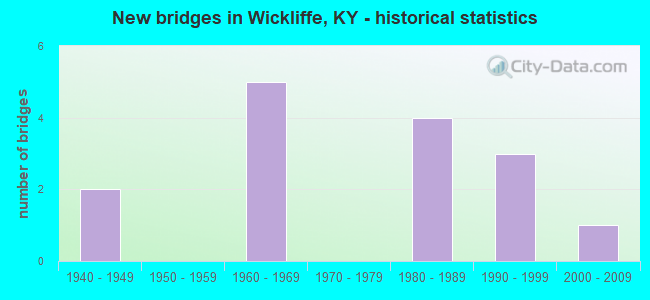
- New bridges - historical statistics
- 21940-1949
- 51960-1969
- 41980-1989
- 31990-1999
- 12000-2009


- Bridge Condition - Deck
- 25.0%Good
- 50.0%Satisfactory
- 8.3%Fair
- 16.7%Poor

- Bridge Condition - Superstructure
- 8.3%Very good
- 41.7%Good
- 25.0%Satisfactory
- 16.7%Fair
- 8.3%Poor

- Bridge Condition - Substructure
- 8.3%Very good
- 41.7%Good
- 25.0%Satisfactory
- 8.3%Fair
- 16.7%Poor

- Bridge Condition - Channel
- 30.8%Good
- 30.8%Satisfactory
- 23.1%Fair
- 7.7%Poor
- 7.7%Serious

- Bridge Condition - Culverts
- 50.0%Satisfactory
- 50.0%Serious
Find on map >> Show street view
Structure Number: 4B00026N, Location: 3.3 MI EAST OF JCT US51&6 (Lat: 36.941111, Lng: -89.038056), Route carried "on" structure: State highway 121, Year Built: 1942, Status: Posted for load, Structure Length: 3.02m (9.91ft), Average Daily Traffic: 1,303 (year 2019), Truck Traffic: 25%, Average Future Daily Traffic: 1,081 (year 2039), Design Load: H 15, Features Intersected: SHELTON CREEK
Minimum Vertical Clearance: 30+ m (98+ ft), Kilometerpoint: 8.624, Lanes on structure: 2, Base Highway Network: Yes, Owner: State Highway Agency, Approaching Roadway Width: 8.5m (27.9ft), Material/Design: Concrete, Design/Construction: Tee Beam, Number Of Spans In Main Unit: 3, Length of Maximum Span: 9.1m (29.9ft), Curb or Sidewalk Widths: Left: 0.3m (1.0ft), Right: 0.3m (1.0ft), Curb-To-Curb Width: 7.2m (23.6ft), Out-to-Out Width: 8.5m (27.9ft)
Condition: Deck: Good, Superstructure: Good, Substructure: Good, Channel: Good, Operating Rating: 56.3 metric tons, Method Used To Determine Operating Rating: Load Factor (LF), Inventory Rating: 33.8 metric tons, Method Used To Determine Inventory Rating: Load Factor (LF), Structural Evaluation: Better than present minimum criteria, Deck Geometry: High priority of corrective action, Waterway Adequacy: Equal to present minimum criteria, Approach Roadway Alignment: Equal to present desirable criteria, Bridge Posting: Required (Relationship of Operating Rating to Maximum Legal Load: 20.0 - 29.9% below), Length Of Structure Improvement: 0.30m (0.98ft), Designated Inspection Frequency: Every 24 months, Inspection Date: July 2021, Bridge Improvement Cost: $345,000, Total Project Cost: $345,000, Deck Structure Type: Concrete Cast-file-Place, Wearing Surface/Protective System: Wearing Surface: Low Slump Concrete
Find on map >> Show street view
Structure Number: 4B00052N, Location: .15 MI NOR. OF JCT KY 121 (Lat: 36.966389, Lng: -89.085278), Route carried "on" structure: State highway 1290, Year Built: 1969, Status: Open, Structure Length: 0.73m (2.40ft), Average Daily Traffic: 345 (year 2019), Average Future Daily Traffic: 303 (year 2039), Design Load: H 20, Features Intersected: UNNAMED STREAM
Minimum Vertical Clearance: 30+ m (98+ ft), Kilometerpoint: 0.267, Lanes on structure: 2, Owner: State Highway Agency, Approaching Roadway Width: 5.5m (18.0ft), Skew: 3 degrees, Material/Design: Prestressed concrete, Design/Construction: Box Beam or Girders - Multiple, Number Of Spans In Main Unit: 1, Length of Maximum Span: 6.7m (22.0ft), Curb or Sidewalk Widths: Left: 0.2m (0.7ft), Right: 0.2m (0.7ft), Curb-To-Curb Width: 6.7m (22.0ft), Out-to-Out Width: 7.3m (24.0ft)
Condition: Deck: Satisfactory, Superstructure: Satisfactory, Substructure: Satisfactory, Channel: Good, Operating Rating: 76.5 metric tons, Method Used To Determine Operating Rating: Load Factor (LF), Inventory Rating: 45.9 metric tons, Method Used To Determine Inventory Rating: Load Factor (LF), Structural Evaluation: Equal to present minimum criteria, Deck Geometry: Meets minimum limits, Waterway Adequacy: Superior to present desirable criteria, Approach Roadway Alignment: Equal to present desirable criteria, Designated Inspection Frequency: Every 24 months, Inspection Date: July 2021, Deck Structure Type: Concrete Precast Panels
Find on map >> Show street view
Structure Number: 4B00054N, Location: 3.0 MI NOR. OF JCT KY 121 (Lat: 36.985833, Lng: -89.044167), Route carried "on" structure: State highway 1290, Year Built: 1965, Status: Posted for load, Structure Length: 0.70m (2.30ft), Average Daily Traffic: 345 (year 2019), Average Future Daily Traffic: 303 (year 2039), Design Load: H 15, Features Intersected: BRANCH OF CANE CREEK
Minimum Vertical Clearance: 30+ m (98+ ft), Kilometerpoint: 4.965, Lanes on structure: 2, Owner: State Highway Agency, Approaching Roadway Width: 5.5m (18.0ft), Material/Design: Concrete, Design/Construction: Culvert, Number Of Spans In Main Unit: 2, Length of Maximum Span: 3.0m (9.8ft)
Condition: Channel: Fair, Culverts: Satisfactory, Operating Rating: 20.0 metric tons, Method Used To Determine Operating Rating: Field evaluation and documented engineering judgment, Inventory Rating: 20.0 metric tons, Method Used To Determine Inventory Rating: Field evaluation and documented engineering judgment, Structural Evaluation: Somewhat better than minimum adequacy, Waterway Adequacy: Superior to present desirable criteria, Approach Roadway Alignment: Equal to present desirable criteria, Bridge Posting: Required (Relationship of Operating Rating to Maximum Legal Load: > 39.9% below), Designated Inspection Frequency: Every 24 months, Inspection Date: July 2021
Find on map >> Show street view
Structure Number: 4B00055N, Location: 3.9 MI NOR. OF JCT KY 121 (Lat: 36.993611, Lng: -89.029722), Route carried "on" structure: State highway 1290, Year Built: 1965, Status: Posted for load, Structure Length: 1.07m (3.51ft), Average Daily Traffic: 345 (year 2019), Average Future Daily Traffic: 303 (year 2039), Features Intersected: CANE CREEK
Minimum Vertical Clearance: 30+ m (98+ ft), Kilometerpoint: 6.573, Lanes on structure: 2, Owner: State Highway Agency, Approaching Roadway Width: 5.5m (18.0ft), Skew: 3 degrees, Material/Design: Concrete, Design/Construction: Culvert, Number Of Spans In Main Unit: 2, Length of Maximum Span: 4.3m (14.1ft)
Condition: Channel: Serious, Culverts: Serious, Operating Rating: 9.1 metric tons, Method Used To Determine Operating Rating: Field evaluation and documented engineering judgment, Inventory Rating: 9.1 metric tons, Method Used To Determine Inventory Rating: Field evaluation and documented engineering judgment, Structural Evaluation: High priority of replacement, Waterway Adequacy: Superior to present desirable criteria, Approach Roadway Alignment: Equal to present desirable criteria, Bridge Posting: Required (Relationship of Operating Rating to Maximum Legal Load: > 39.9% below), Designated Inspection Frequency: Every 6 months, Inspection Date: July 2021
Find on map >> Show street view
Structure Number: 4B00056N, Location: 1.9 MI.EAST OF US 51 (Lat: 36.992222, Lng: -89.072500), Route carried "on" structure: US 60, Year Built: 1985, Status: Open, Structure Length: 3.60m (11.81ft), Average Daily Traffic: 2,923 (year 2019), Truck Traffic: 23%, Average Future Daily Traffic: 2,747 (year 2039), Design Load: HS 20, Features Intersected: SOUTH FORK-CANE CREEK
Minimum Vertical Clearance: 30+ m (98+ ft), Kilometerpoint: 3.146, Lanes on structure: 2, Base Highway Network: Yes, Owner: State Highway Agency, Approaching Roadway Width: 6.1m (20.0ft), Skew: 5 degrees, Material/Design: Prestressed concrete continuous, Design/Construction: Stringer/Multi-beam, Number Of Spans In Main Unit: 2, Length of Maximum Span: 22.9m (75.1ft), Curb-To-Curb Width: 12.2m (40.0ft), Out-to-Out Width: 13.2m (43.3ft)
Condition: Deck: Satisfactory, Superstructure: Good, Substructure: Good, Channel: Satisfactory, Operating Rating: 90.7 metric tons, Method Used To Determine Operating Rating: Load Factor (LF), Inventory Rating: 54.4 metric tons, Method Used To Determine Inventory Rating: Load Factor (LF), Structural Evaluation: Better than present minimum criteria, Deck Geometry: Equal to present minimum criteria, Waterway Adequacy: Superior to present desirable criteria, Approach Roadway Alignment: Equal to present desirable criteria, Designated Inspection Frequency: Every 24 months, Inspection Date: August 2020, Deck Structure Type: Concrete Cast-file-Place, Wearing Surface/Protective System: Wearing Surface: Monolithic Concrete, Deck Protection: Epoxy Coated Reinforcing
Find on map >> Show street view
Structure Number: 4B00060N, Location: S KY 121 @ WICKLIFFE (Lat: 36.962500, Lng: -89.089722), Route carried "on" structure: US 51, Year Built: 1990, Status: Open, Structure Length: 11.43m (37.50ft), Average Daily Traffic: 2,485 (year 2020), Truck Traffic: 23%, Average Future Daily Traffic: 2,062 (year 2040), Design Load: HS 20, Features Intersected: IC Railway and Beech Cr.
Minimum Vertical Clearance: 30+ m (98+ ft), Kilometerpoint: 5.180, Lanes on structure: 2, Base Highway Network: Yes, Owner: State Highway Agency, Approaching Roadway Width: 14.6m (47.9ft), Skew: 3 degrees, Material/Design: Prestressed concrete continuous, Design/Construction: Stringer/Multi-beam, Number Of Spans In Main Unit: 5, Length of Maximum Span: 25.6m (84.0ft), Curb-To-Curb Width: 13.4m (44.0ft), Out-to-Out Width: 14.4m (47.2ft)
Condition: Deck: Satisfactory, Superstructure: Good, Substructure: Good, Channel: Fair, Operating Rating: 99.8 metric tons, Method Used To Determine Operating Rating: Load Factor (LF), Inventory Rating: 60.1 metric tons, Method Used To Determine Inventory Rating: Load Factor (LF), Structural Evaluation: Better than present minimum criteria, Deck Geometry: Better than present minimum criteria, Underclear: Somewhat better than minimum adequacy, Waterway Adequacy: Superior to present desirable criteria, Approach Roadway Alignment: Equal to present desirable criteria, Designated Inspection Frequency: Every 24 months, Inspection Date: August 2020, Deck Structure Type: Concrete Cast-file-Place, Wearing Surface/Protective System: Wearing Surface: Monolithic Concrete, Deck Protection: Epoxy Coated Reinforcing
Find on map >> Show street view
Structure Number: 4B00061N, Location: 2.5 MI.NE JCT US 51 (Lat: 36.998333, Lng: -89.066389), Route carried "on" structure: US 60, Year Built: 1993, Status: Open, Structure Length: 3.02m (9.91ft), Average Daily Traffic: 2,923 (year 2019), Truck Traffic: 23%, Average Future Daily Traffic: 2,747 (year 2039), Design Load: HS 25 or greater, Features Intersected: BIG CANE CREEK
Minimum Vertical Clearance: 30+ m (98+ ft), Kilometerpoint: 4.028, Lanes on structure: 2, Base Highway Network: Yes, Owner: State Highway Agency, Approaching Roadway Width: 13.4m (44.0ft), Material/Design: Prestressed concrete, Design/Construction: Stringer/Multi-beam, Number Of Spans In Main Unit: 1, Length of Maximum Span: 28.3m (92.8ft), Curb-To-Curb Width: 13.4m (44.0ft), Out-to-Out Width: 14.4m (47.2ft)
Condition: Deck: Good, Superstructure: Very good, Substructure: Very good, Channel: Satisfactory, Operating Rating: 94.0 metric tons, Method Used To Determine Operating Rating: Load Factor (LF), Inventory Rating: 56.4 metric tons, Method Used To Determine Inventory Rating: Load Factor (LF), Structural Evaluation: Equal to present desirable criteria, Deck Geometry: Better than present minimum criteria, Waterway Adequacy: Equal to present desirable criteria, Approach Roadway Alignment: Equal to present desirable criteria, Designated Inspection Frequency: Every 24 months, Inspection Date: March 2020, Deck Structure Type: Concrete Cast-file-Place, Wearing Surface/Protective System: Wearing Surface: Monolithic Concrete, Deck Protection: Epoxy Coated Reinforcing
Find on map >> Show street view
Structure Number: 4B00066N, Location: .6 MI. W JCT US 60 (Lat: 36.977500, Lng: -89.099444), Route carried "on" structure: US 51, Year Built: 2000, Year Reconstructed: 2001, Status: Open, Structure Length: 100.77m (330.61ft), Average Daily Traffic: 5,779 (year 2020), Truck Traffic: 34%, Average Future Daily Traffic: 5,432 (year 2040), Design Load: HS 25 or greater, Features Intersected: WILLOW SLOUGH
Minimum Vertical Clearance: 30+ m (98+ ft), Kilometerpoint: 7.339, Lanes on structure: 2, Base Highway Network: Yes, Owner: State Highway Agency, Approaching Roadway Width: 13.4m (44.0ft), Material/Design: Prestressed concrete, Design/Construction: Stringer/Multi-beam, Number Of Spans In Main Unit: 24, Length of Maximum Span: 41.8m (137.1ft), Curb or Sidewalk Widths: Left: 0.5m (1.6ft), Right: 0.5m (1.6ft), Curb-To-Curb Width: 13.1m (43.0ft), Out-to-Out Width: 14.2m (46.6ft)
Condition: Deck: Good, Superstructure: Good, Substructure: Good, Channel: Good, Operating Rating: 79.5 metric tons, Method Used To Determine Operating Rating: Load Factor (LF), Inventory Rating: 47.7 metric tons, Method Used To Determine Inventory Rating: Load Factor (LF), Structural Evaluation: Better than present minimum criteria, Deck Geometry: Somewhat better than minimum adequacy, Waterway Adequacy: Superior to present desirable criteria, Approach Roadway Alignment: Equal to present desirable criteria, Designated Inspection Frequency: Every 24 months, Inspection Date: September 2021, Deck Structure Type: Concrete Cast-file-Place, Wearing Surface/Protective System: Wearing Surface: Monolithic Concrete, Deck Protection: Epoxy Coated Reinforcing
Find on map >> Show street view
Structure Number: 4C00032N, Location: .75 MI E OF JCT KY 121 (Lat: 36.951944, Lng: -89.041389), Route carried "on" structure: County highway 1213, Year Built: 1942, Status: Posted for load, Structure Length: 0.73m (2.40ft), Average Daily Traffic: 228 (year 2010), Average Future Daily Traffic: 198 (year 2030), Features Intersected: BR OF SHELTON CREEK, Facility Carried by Structure: BETHLEHEM CHURCH R
Minimum Vertical Clearance: 30+ m (98+ ft), Kilometerpoint: 1.688, Lanes on structure: 2, Owner: County Highway Agency, Approaching Roadway Width: 4.3m (14.1ft), Material/Design: Concrete, Design/Construction: Slab, Number Of Spans In Main Unit: 1, Length of Maximum Span: 6.7m (22.0ft), Curb or Sidewalk Widths: Left: 0.2m (0.7ft), Right: 0.2m (0.7ft), Curb-To-Curb Width: 4.9m (16.1ft), Out-to-Out Width: 5.7m (18.7ft)
Condition: Deck: Poor, Superstructure: Poor, Substructure: Poor, Channel: Fair, Operating Rating: 11.8 metric tons, Method Used To Determine Operating Rating: Field evaluation and documented engineering judgment, Inventory Rating: 11.8 metric tons, Method Used To Determine Inventory Rating: Field evaluation and documented engineering judgment, Structural Evaluation: Meets minimum limits, Deck Geometry: High priority of replacement, Waterway Adequacy: Meets minimum limits, Approach Roadway Alignment: Equal to present minimum criteria, Bridge Posting: Required (Relationship of Operating Rating to Maximum Legal Load: > 39.9% below), Length Of Structure Improvement: 0.07m (0.23ft), Designated Inspection Frequency: Every 12 months, Inspection Date: August 2021, Bridge Improvement Cost: $67,000, Roadway Improvement Cost: $7,000, Total Project Cost: $73,000, Deck Structure Type: Concrete Cast-file-Place, Wearing Surface/Protective System: Wearing Surface: Bituminous
Find on map >> Show street view
Structure Number: 4C00057N, Location: 2.4 MI SW OF U.S. 60 (Lat: 37.015278, Lng: -89.097222), Route carried "on" structure: County highway 1222, Year Built: 1981, Status: Posted for load, Structure Length: 0.91m (2.99ft), Average Daily Traffic: 110 (year 2006), Average Future Daily Traffic: 133 (year 2026), Features Intersected: SHAWNEE CREEK SLOUGH, Facility Carried by Structure: GUM CORNER ROAD
Minimum Vertical Clearance: 30+ m (98+ ft), Kilometerpoint: 3.969, Lanes on structure: 1, Owner: County Highway Agency, Approaching Roadway Width: 4.9m (16.1ft), Material/Design: Steel, Design/Construction: Stringer/Multi-beam, Number Of Spans In Main Unit: 1, Length of Maximum Span: 8.2m (26.9ft), Curb or Sidewalk Widths: Left: 0.2m (0.7ft), Right: 0.5m (1.6ft), Curb-To-Curb Width: 3.7m (12.1ft), Out-to-Out Width: 4.4m (14.4ft)
Condition: Deck: Poor, Superstructure: Fair, Substructure: Fair, Channel: Good, Operating Rating: 14.5 metric tons, Method Used To Determine Operating Rating: Load Factor (LF), Inventory Rating: 14.5 metric tons, Method Used To Determine Inventory Rating: Load Factor (LF), Structural Evaluation: Meets minimum limits, Deck Geometry: High priority of replacement, Waterway Adequacy: Meets minimum limits, Approach Roadway Alignment: Meets minimum limits, Bridge Posting: Required (Relationship of Operating Rating to Maximum Legal Load: > 39.9% below), Length Of Structure Improvement: 0.09m (0.30ft), Designated Inspection Frequency: Every 12 months, Inspection Date: August 2021, Bridge Improvement Cost: $65,000, Roadway Improvement Cost: $8,000, Total Project Cost: $73,000, Deck Structure Type: Wood or Timber, Wearing Surface/Protective System: Wearing Surface: Wood or Timber
Find on map >> Show street view
Structure Number: 4C00058N, Location: 1.0 MI E OF JCT KY 121 (Lat: 36.951389, Lng: -89.034444), Route carried "on" structure: County highway 1213, Year Built: 1986, Status: Posted for load, Structure Length: 0.91m (2.99ft), Average Daily Traffic: 228 (year 2010), Average Future Daily Traffic: 198 (year 2030), Design Load: H 20, Features Intersected: SHELTON CREEK, Facility Carried by Structure: BETHLEHEM CHURCH R
Minimum Vertical Clearance: 30+ m (98+ ft), Kilometerpoint: 2.303, Lanes on structure: 2, Owner: County Highway Agency, Approaching Roadway Width: 4.3m (14.1ft), Material/Design: Concrete, Design/Construction: Channel Beam, Number Of Spans In Main Unit: 1, Length of Maximum Span: 8.8m (28.9ft), Curb or Sidewalk Widths: Left: 0.2m (0.7ft), Right: 0.2m (0.7ft), Curb-To-Curb Width: 6.3m (20.7ft), Out-to-Out Width: 6.6m (21.7ft)
Condition: Deck: Fair, Superstructure: Fair, Substructure: Poor, Channel: Poor, Operating Rating: 25.7 metric tons, Method Used To Determine Operating Rating: Load Factor (LF), Inventory Rating: 15.4 metric tons, Method Used To Determine Inventory Rating: Load Factor (LF), Structural Evaluation: Meets minimum limits, Deck Geometry: Meets minimum limits, Waterway Adequacy: Meets minimum limits, Approach Roadway Alignment: Somewhat better than minimum adequacy, Bridge Posting: Required (Relationship of Operating Rating to Maximum Legal Load: > 39.9% below), Designated Inspection Frequency: Every 12 months, Inspection Date: August 2021, Deck Structure Type: Concrete Precast Panels, Wearing Surface/Protective System: Wearing Surface: Bituminous
Find on map >> Show street view
Structure Number: 4C00071N, Location: 0.8 MI N JCT KY 1290 (Lat: 36.992778, Lng: -89.052222), Route carried "on" structure: County highway 1207, Year Built: 1990, Status: Open, Structure Length: 2.13m (6.99ft), Average Daily Traffic: 41 (year 2010), Average Future Daily Traffic: 35 (year 2030), Design Load: HS 20, Features Intersected: CANE CREEK, Facility Carried by Structure: BORDEN ROAD
Minimum Vertical Clearance: 30+ m (98+ ft), Kilometerpoint: 1.292, Lanes on structure: 2, Owner: County Highway Agency, Approaching Roadway Width: 4.9m (16.1ft), Material/Design: Prestressed concrete, Design/Construction: Box Beam or Girders - Multiple, Number Of Spans In Main Unit: 1, Length of Maximum Span: 20.4m (66.9ft), Curb or Sidewalk Widths: Left: 0.2m (0.7ft), Right: 0.2m (0.7ft), Curb-To-Curb Width: 6.1m (20.0ft), Out-to-Out Width: 6.5m (21.3ft)
Condition: Deck: Satisfactory, Superstructure: Satisfactory, Substructure: Satisfactory, Channel: Satisfactory, Operating Rating: 84.2 metric tons, Method Used To Determine Operating Rating: Load Factor (LF), Inventory Rating: 50.5 metric tons, Method Used To Determine Inventory Rating: Load Factor (LF), Structural Evaluation: Equal to present minimum criteria, Deck Geometry: Somewhat better than minimum adequacy, Waterway Adequacy: Better than present minimum criteria, Approach Roadway Alignment: Somewhat better than minimum adequacy, Designated Inspection Frequency: Every 24 months, Inspection Date: August 2021, Deck Structure Type: Concrete Precast Panels, Wearing Surface/Protective System: Wearing Surface: Monolithic Concrete
Find on map >> Show street view
Structure Number: 4X00001N, Location: 1.5 MI S KY 121 (Lat: 36.943889, Lng: -89.088333), Route carried "on" structure: Other road 1205, Year Built: 1968, Status: Open, Structure Length: 4.60m (15.09ft), Design Load: HS 20, Features Intersected: US 51 @ 1.871
Minimum Vertical Clearance: 30+ m (98+ ft), Kilometerpoint: 0.344, Lanes on structure: 2, Lanes under structure: 2, Owner: Private, Approaching Roadway Width: 7.7m (25.3ft), Skew: 30 degrees, Material/Design: Steel, Design/Construction: Girder and Floorbeam System, Number Of Spans In Main Unit: 3, Length of Maximum Span: 19.2m (63.0ft), Curb or Sidewalk Widths: Left: 0.4m (1.3ft), Right: 0.4m (1.3ft), Curb-To-Curb Width: 7.7m (25.3ft), Out-to-Out Width: 10.5m (34.4ft)
Condition: Deck: Satisfactory, Superstructure: Satisfactory, Substructure: Good, Operating Rating: 43.3 metric tons, Method Used To Determine Operating Rating: Load Factor (LF), Inventory Rating: 25.9 metric tons, Method Used To Determine Inventory Rating: Load Factor (LF), Structural Evaluation: Equal to present minimum criteria, Deck Geometry: Equal to present minimum criteria, Underclear: Meets minimum limits, Approach Roadway Alignment: Meets minimum limits, Bridge Posting: Required (Relationship of Operating Rating to Maximum Legal Load: > 39.9% below), Designated Inspection Frequency: Every 24 months, Inspection Date: November 2021, Deck Structure Type: Concrete Cast-file-Place, Wearing Surface/Protective System: Wearing Surface: Monolithic Concrete
Find on map >> Show street view
Structure Number: 20B00058N, Location: BALLARD -CARLISLE CO LINE (Lat: 36.927778, Lng: -89.062778), Route carried "on" structure: US 51, Year Built: 1986, Status: Open, Structure Length: 20.82m (68.31ft), Average Daily Traffic: 1,250 (year 2018), Truck Traffic: 23%, Average Future Daily Traffic: 1,037 (year 2038), Design Load: HS 20+Mod, Features Intersected: MAYFIELD CREEK
Minimum Vertical Clearance: 30+ m (98+ ft), Kilometerpoint: 20.340, Lanes on structure: 2, Base Highway Network: Yes, Owner: State Highway Agency, Approaching Roadway Width: 6.1m (20.0ft), Material/Design: Prestressed concrete continuous, Design/Construction: Stringer/Multi-beam, Number Of Spans In Main Unit: 9, Length of Maximum Span: 24.4m (80.1ft), Curb-To-Curb Width: 12.2m (40.0ft), Out-to-Out Width: 13.2m (43.3ft)
Condition: Deck: Satisfactory, Superstructure: Good, Substructure: Satisfactory, Channel: Satisfactory, Operating Rating: 54.2 metric tons, Method Used To Determine Operating Rating: Load Factor (LF), Inventory Rating: 32.6 metric tons, Method Used To Determine Inventory Rating: Load Factor (LF), Structural Evaluation: Equal to present minimum criteria, Deck Geometry: Better than present minimum criteria, Waterway Adequacy: Better than present minimum criteria, Approach Roadway Alignment: Equal to present desirable criteria, Designated Inspection Frequency: Every 24 months, Inspection Date: May 2021, Deck Structure Type: Concrete Cast-file-Place, Wearing Surface/Protective System: Wearing Surface: Monolithic Concrete, Deck Protection: Epoxy Coated Reinforcing
Find on map >> Show street view
Structure Number: 4X00001N, Location: 1.5 MI S KY 121 (Lat: 36.943889, Lng: -89.088333), Route carried "under" structure: US 51, Year Built: 1968, Structure Length: 0. m, Average Daily Traffic: 1,250 (year 2018), Truck Traffic: 23%, Features Intersected: US 51 @ 1.871, Facility Carried by Structure: PR-1205
Minimum Vertical Clearance: 4.82m (15.81ft), Kilometerpoint: 2.984, Lanes on structure: 2, Lanes under structure: 2, Material/Design: Steel, Design/Construction: Girder and Floorbeam System, Length of Maximum Span: 19.2m (63.0ft)