Bridge Statistics for Winnfield, Louisiana (LA)
Condition, Traffic, Stress, Structural Evaluation, Project Costs
- National Bridge Inventory (NBI) Statistics
- 29Number of bridges
- 614ft / 187mTotal length
- $1,995,000Total costs
- 110,580Total average daily traffic
- 15,659Total average daily truck traffic
- 192,355Total future (year 2036) average daily traffic
- National Bridge Inventory (NBI) Registered Bridges for Winnfield
- No street view available for this location
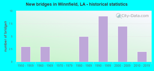
- New bridges - historical statistics
- 31950-1959
- 31960-1969
- 51980-1989
- 91990-1999
- 72000-2009
- 22010-2019

- Reconstructed bridges - Historical Statistics
- 11990-1999
- 12000-2009
- 22010-2019


- Bridge Condition - Deck
- 17.4%Very good
- 56.5%Good
- 13.0%Satisfactory
- 4.3%Poor
- 8.7%Serious

- Bridge Condition - Superstructure
- 13.0%Very good
- 56.5%Good
- 13.0%Satisfactory
- 4.3%Fair
- 4.3%Poor
- 8.7%Serious

- Bridge Condition - Substructure
- 13.0%Very good
- 52.2%Good
- 13.0%Satisfactory
- 8.7%Fair
- 4.3%Poor
- 8.7%Serious

- Bridge Condition - Channel
- 33.3%Very good
- 33.3%Good
- 18.5%Satisfactory
- 11.1%Fair
- 3.7%Poor

- Bridge Condition - Culverts
- 33.3%Very good
- 50.0%Good
- 16.7%Fair
Find on map >> Show street view
Structure Number: 86400000080539, Location: 7.48 MI. NORTH OF LA 500 (Lat: 31.897411, Lng: -92.607000), Route carried "on" structure: US 167, Year Built: 2009, Status: Open, Structure Length: 6.10m (20.01ft), Average Daily Traffic: 4,050 (year 2016), Truck Traffic: 15%, Average Future Daily Traffic: 8,058 (year 2036), Design Load: HS 20, Features Intersected: CEDAR CREEK
Minimum Vertical Clearance: 30+ m (98+ ft), Kilometerpoint: 4.966, Lanes on structure: 2, Base Highway Network: Yes (Inventory Route: 23-04-2, Subroute: 10), Owner: State Highway Agency, Approaching Roadway Width: 11.6m (38.1ft), Skew: 30 degrees, Material/Design: Concrete, Design/Construction: Slab, Number Of Spans In Main Unit: 10, Length of Maximum Span: 6.1m (20.0ft), Curb-To-Curb Width: 12.0m (39.4ft), Out-to-Out Width: 13.0m (42.7ft)
Condition: Deck: Good, Superstructure: Good, Substructure: Very good, Channel: Very good, Operating Rating: 36.3 metric tons, Method Used To Determine Operating Rating: Load and Resistance Factor Rating (LRFR) rating reported by rating factor(RF) method using HL-93 loadings, Inventory Rating: 28.2 metric tons, Method Used To Determine Inventory Rating: Load and Resistance Factor Rating (LRFR) rating reported by rating factor(RF) method using HL-93 loadings, Structural Evaluation: Better than present minimum criteria, Deck Geometry: Better than present minimum criteria, Waterway Adequacy: Equal to present desirable criteria, Approach Roadway Alignment: Superior to present desirable criteria, Designated Inspection Frequency: Every 24 months, Inspection Date: December 2021, Deck Structure Type: Concrete Cast-file-Place, Wearing Surface/Protective System: Wearing Surface: Monolithic Concrete
Find on map >> Show street view
Structure Number: 86400000080559, Location: 1.69 MI. SOUTH OF LA 505 (Lat: 31.974019, Lng: -92.653200), Route carried "on" structure: US 167, Year Built: 2010, Status: Open, Structure Length: 26.82m (87.99ft), Average Daily Traffic: 8,000 (year 2016), Truck Traffic: 15%, Average Future Daily Traffic: 7,956 (year 2036), Design Load: HS 20, Features Intersected: DUGDEMONA RIVER
Minimum Vertical Clearance: 30+ m (98+ ft), Kilometerpoint: 6.537, Lanes on structure: 2, Base Highway Network: Yes (Inventory Route: 23-05-1, Subroute: 10), Owner: State Highway Agency, Approaching Roadway Width: 12.2m (40.0ft), Skew: 30 degrees, Material/Design: Prestressed concrete continuous, Design/Construction: Stringer/Multi-beam, Number Of Spans In Main Unit: 11, Length of Maximum Span: 25.0m (82.0ft), Curb-To-Curb Width: 12.0m (39.4ft), Out-to-Out Width: 13.0m (42.7ft)
Condition: Deck: Good, Superstructure: Good, Substructure: Satisfactory, Channel: Very good, Operating Rating: 52.2 metric tons, Method Used To Determine Operating Rating: Load and Resistance Factor Rating (LRFR) rating reported by rating factor(RF) method using HL-93 loadings, Inventory Rating: 30.1 metric tons, Method Used To Determine Inventory Rating: Load and Resistance Factor Rating (LRFR) rating reported by rating factor(RF) method using HL-93 loadings, Structural Evaluation: Equal to present minimum criteria, Deck Geometry: Somewhat better than minimum adequacy, Waterway Adequacy: Equal to present minimum criteria, Approach Roadway Alignment: Equal to present desirable criteria, Designated Inspection Frequency: Every 24 months, Inspection Date: December 2021, Deck Structure Type: Concrete Cast-file-Place, Wearing Surface/Protective System: Wearing Surface: Monolithic Concrete
Find on map >> Show street view
Structure Number: 86400000080619, Location: 0.4 MI. NORTH OF LA 1231- (Lat: 31.976481, Lng: -92.653500), Route carried "on" structure: US 167, Year Built: 2013, Status: Open, Structure Length: 26.82m (87.99ft), Average Daily Traffic: 4,000 (year 2016), Truck Traffic: 15%, Average Future Daily Traffic: 7,956 (year 2036), Design Load: HL 93, Features Intersected: DUGDEMONA RIVER
Minimum Vertical Clearance: 30+ m (98+ ft), Kilometerpoint: 20.476, Lanes on structure: 2, Base Highway Network: Yes (Inventory Route: 23-05-2, Subroute: 10), Owner: State Highway Agency, Approaching Roadway Width: 12.2m (40.0ft), Skew: 30 degrees, Material/Design: Prestressed concrete continuous, Design/Construction: Stringer/Multi-beam, Number Of Spans In Main Unit: 11, Length of Maximum Span: 25.0m (82.0ft), Curb-To-Curb Width: 12.0m (39.4ft), Out-to-Out Width: 13.0m (42.7ft)
Condition: Deck: Good, Superstructure: Good, Substructure: Good, Channel: Very good, Operating Rating: 53.5 metric tons, Method Used To Determine Operating Rating: Load and Resistance Factor Rating (LRFR) rating reported by rating factor(RF) method using HL-93 loadings, Inventory Rating: 41.1 metric tons, Method Used To Determine Inventory Rating: Load and Resistance Factor Rating (LRFR) rating reported by rating factor(RF) method using HL-93 loadings, Structural Evaluation: Better than present minimum criteria, Deck Geometry: Better than present minimum criteria, Waterway Adequacy: Superior to present desirable criteria, Approach Roadway Alignment: Superior to present desirable criteria, Designated Inspection Frequency: Every 24 months, Inspection Date: December 2021, Deck Structure Type: Concrete Cast-file-Place, Wearing Surface/Protective System: Wearing Surface: Monolithic Concrete
Find on map >> Show street view
Structure Number: 86400220200001, Location: 1.5 MI E JCT LA 1226 (Lat: 31.818661, Lng: -92.948881), Route carried "on" structure: US 84, Year Built: 1983, Status: Open, Structure Length: 9.21m (30.22ft), Average Daily Traffic: 3,400 (year 2016), Truck Traffic: 15%, Average Future Daily Traffic: 5,780 (year 2036), Design Load: HS 20, Features Intersected: SALINE BAYOU
Minimum Vertical Clearance: 30+ m (98+ ft), Kilometerpoint: 0.010, Lanes on structure: 2, Base Highway Network: Yes (Inventory Route: 22-02-1, Subroute: 10), Owner: State Highway Agency, Approaching Roadway Width: 12.2m (40.0ft), Skew: 30 degrees, Material/Design: Prestressed concrete continuous, Design/Construction: Stringer/Multi-beam, Number Of Spans In Main Unit: 6, Length of Maximum Span: 15.2m (49.9ft), Curb-To-Curb Width: 12.2m (40.0ft), Out-to-Out Width: 13.0m (42.7ft)
Condition: Deck: Good, Superstructure: Fair, Substructure: Fair, Channel: Satisfactory, Operating Rating: 26.9 metric tons, Method Used To Determine Operating Rating: Load and Resistance Factor Rating (LRFR) rating reported by rating factor(RF) method using HL-93 loadings, Inventory Rating: 20.7 metric tons, Method Used To Determine Inventory Rating: Load and Resistance Factor Rating (LRFR) rating reported by rating factor(RF) method using HL-93 loadings, Structural Evaluation: Somewhat better than minimum adequacy, Deck Geometry: Equal to present minimum criteria, Waterway Adequacy: Equal to present minimum criteria, Approach Roadway Alignment: Equal to present desirable criteria, Designated Inspection Frequency: Every 24 months, Underwater Inspection Frequency: Every 60 months, Inspection Date: August 2021, Underwater Inspection Date: March 2018, Deck Structure Type: Concrete Cast-file-Place, Wearing Surface/Protective System: Wearing Surface: Monolithic Concrete
Find on map >> Show street view
Structure Number: 86400220218641, Location: 3.0 MI EAST OF LA 1228 (Lat: 31.921031, Lng: -92.665700), Route carried "on" structure: US 84, Year Built: 1997, Status: Open, Structure Length: 3.66m (12.01ft), Average Daily Traffic: 3,400 (year 2016), Truck Traffic: 14%, Average Future Daily Traffic: 5,780 (year 2036), Design Load: HS 20, Features Intersected: PORT DE LUCE CREEK
Minimum Vertical Clearance: 30+ m (98+ ft), Kilometerpoint: 30.072, Lanes on structure: 2, Base Highway Network: Yes (Inventory Route: 22-02-1, Subroute: 10), Owner: State Highway Agency, Approaching Roadway Width: 13.4m (44.0ft), Skew: 30 degrees, Material/Design: Concrete, Design/Construction: Slab, Number Of Spans In Main Unit: 6, Length of Maximum Span: 6.1m (20.0ft), Curb-To-Curb Width: 13.3m (43.6ft), Out-to-Out Width: 14.2m (46.6ft)
Condition: Deck: Good, Superstructure: Good, Substructure: Good, Channel: Good, Operating Rating: 73.5 metric tons, Method Used To Determine Operating Rating: Load Factor (LF), Inventory Rating: 43.5 metric tons, Method Used To Determine Inventory Rating: Load Factor (LF), Structural Evaluation: Better than present minimum criteria, Deck Geometry: Equal to present minimum criteria, Waterway Adequacy: Equal to present desirable criteria, Approach Roadway Alignment: Equal to present desirable criteria, Designated Inspection Frequency: Every 24 months, Inspection Date: August 2021, Deck Structure Type: Concrete Cast-file-Place, Wearing Surface/Protective System: Wearing Surface: Monolithic Concrete
Find on map >> Show street view
Structure Number: 86400220218751, Location: 3.1 MI EAST OF LA 1228 (Lat: 31.921031, Lng: -92.663800), Route carried "on" structure: US 84, Year Built: 1997, Status: Open, Structure Length: 0.94m (3.08ft), Average Daily Traffic: 3,400 (year 2016), Truck Traffic: 14%, Average Future Daily Traffic: 5,780 (year 2036), Design Load: HS 20, Features Intersected: PORT DE LUCE CREEK
Minimum Vertical Clearance: 30+ m (98+ ft), Kilometerpoint: 30.251, Lanes on structure: 2, Base Highway Network: Yes (Inventory Route: 22-02-1, Subroute: 10), Owner: State Highway Agency, Approaching Roadway Width: 13.4m (44.0ft), Skew: 30 degrees, Material/Design: Concrete, Design/Construction: Culvert, Number Of Spans In Main Unit: 3, Length of Maximum Span: 2.7m (8.9ft)
Condition: Channel: Good, Culverts: Very good, Operating Rating: 42.1 metric tons, Method Used To Determine Operating Rating: Load and Resistance Factor Rating (LRFR) rating reported by rating factor(RF) method using HL-93 loadings, Inventory Rating: 32.4 metric tons, Method Used To Determine Inventory Rating: Load and Resistance Factor Rating (LRFR) rating reported by rating factor(RF) method using HL-93 loadings, Structural Evaluation: Equal to present desirable criteria, Waterway Adequacy: Better than present minimum criteria, Approach Roadway Alignment: Equal to present desirable criteria, Designated Inspection Frequency: Every 24 months, Inspection Date: August 2021, Deck Structure Type: Concrete Cast-file-Place
Find on map >> Show street view
Structure Number: 86400220219471, Location: 3.8 MI EAST OF LA 1228 (Lat: 31.925000, Lng: -92.653600), Route carried "on" structure: US 84, Year Built: 1959, Year Reconstructed: 2016, Status: Open, Structure Length: 3.69m (12.11ft), Average Daily Traffic: 4,800 (year 2016), Truck Traffic: 14%, Average Future Daily Traffic: 8,160 (year 2036), Design Load: HS 20, Features Intersected: LAS RR
Minimum Vertical Clearance: 30+ m (98+ ft), Kilometerpoint: 31.397, Lanes on structure: 2, Base Highway Network: Yes (Inventory Route: 22-02-1, Subroute: 10), Owner: State Highway Agency, Approaching Roadway Width: 13.4m (44.0ft), Skew: 33 degrees, Material/Design: Steel, Design/Construction: Stringer/Multi-beam, Number Of Spans In Main Unit: 3, Length of Maximum Span: 12.2m (40.0ft), Curb or Sidewalk Widths: Left: 1.5m (4.9ft), Right: 1.5m (4.9ft), Curb-To-Curb Width: 8.5m (27.9ft), Out-to-Out Width: 12.3m (40.4ft)
Condition: Deck: Very good, Superstructure: Good, Substructure: Good, Operating Rating: 47.6 metric tons, Method Used To Determine Operating Rating: Load and Resistance Factor Rating (LRFR) rating reported by rating factor(RF) method using HL-93 loadings, Inventory Rating: 36.6 metric tons, Method Used To Determine Inventory Rating: Load and Resistance Factor Rating (LRFR) rating reported by rating factor(RF) method using HL-93 loadings, Structural Evaluation: Better than present minimum criteria, Deck Geometry: Meets minimum limits, Underclear: Better than present minimum criteria, Approach Roadway Alignment: Somewhat better than minimum adequacy, Length Of Structure Improvement: 4.60m (15.09ft), Designated Inspection Frequency: Every 24 months, Inspection Date: August 2021, Bridge Improvement Cost: $392,000, Total Project Cost: $588,000 ( Estimate for 2016), Deck Structure Type: Concrete Cast-file-Place, Wearing Surface/Protective System: Wearing Surface: Monolithic Concrete
Find on map >> Show street view
Structure Number: 86400220300691, Location: 0.69 MI EAST JCT. US 167 (Lat: 31.929511, Lng: -92.615600), Route carried "on" structure: US 84, Year Built: 1996, Year Reconstructed: 2004, Status: Open, Structure Length: 4.88m (16.01ft), Average Daily Traffic: 4,800 (year 2016), Truck Traffic: 15%, Average Future Daily Traffic: 8,330 (year 2036), Design Load: HS 20, Features Intersected: DUGDEMONA RIVER RELIEF
Minimum Vertical Clearance: 30+ m (98+ ft), Kilometerpoint: 1.135, Lanes on structure: 2, Base Highway Network: Yes (Inventory Route: 22-03-1, Subroute: 10), Owner: State Highway Agency, Approaching Roadway Width: 13.4m (44.0ft), Skew: 30 degrees, Material/Design: Concrete, Design/Construction: Slab, Number Of Spans In Main Unit: 8, Length of Maximum Span: 6.1m (20.0ft), Curb-To-Curb Width: 13.3m (43.6ft), Out-to-Out Width: 14.3m (46.9ft)
Condition: Deck: Good, Superstructure: Good, Substructure: Good, Channel: Good, Operating Rating: 73.5 metric tons, Method Used To Determine Operating Rating: Load Factor (LF), Inventory Rating: 43.5 metric tons, Method Used To Determine Inventory Rating: Load Factor (LF), Structural Evaluation: Better than present minimum criteria, Deck Geometry: Equal to present minimum criteria, Waterway Adequacy: Equal to present desirable criteria, Approach Roadway Alignment: Equal to present desirable criteria, Designated Inspection Frequency: Every 24 months, Underwater Inspection Frequency: Every 60 months, Inspection Date: August 2021, Underwater Inspection Date: March 2018, Deck Structure Type: Concrete Cast-file-Place, Wearing Surface/Protective System: Wearing Surface: Monolithic Concrete
Find on map >> Show street view
Structure Number: 86400220301051, Location: 1.05 MI EAST JCT US 167 (Lat: 31.932319, Lng: -92.611400), Route carried "on" structure: US 84, Year Built: 1996, Status: Open, Structure Length: 18.90m (62.01ft), Average Daily Traffic: 4,800 (year 2016), Truck Traffic: 15%, Average Future Daily Traffic: 8,330 (year 2036), Design Load: HS 20, Features Intersected: PORT DELUCE CREEK
Minimum Vertical Clearance: 30+ m (98+ ft), Kilometerpoint: 1.640, Lanes on structure: 2, Base Highway Network: Yes (Inventory Route: 22-03-1, Subroute: 10), Owner: State Highway Agency, Approaching Roadway Width: 13.4m (44.0ft), Skew: 30 degrees, Material/Design: Concrete, Design/Construction: Slab, Number Of Spans In Main Unit: 31, Length of Maximum Span: 6.1m (20.0ft), Curb-To-Curb Width: 13.3m (43.6ft), Out-to-Out Width: 14.3m (46.9ft)
Condition: Deck: Good, Superstructure: Good, Substructure: Good, Channel: Very good, Operating Rating: 71.7 metric tons, Method Used To Determine Operating Rating: Load Factor (LF), Inventory Rating: 42.6 metric tons, Method Used To Determine Inventory Rating: Load Factor (LF), Structural Evaluation: Better than present minimum criteria, Deck Geometry: Equal to present minimum criteria, Waterway Adequacy: Equal to present desirable criteria, Approach Roadway Alignment: Equal to present desirable criteria, Designated Inspection Frequency: Every 24 months, Inspection Date: August 2021, Deck Structure Type: Concrete Cast-file-Place, Wearing Surface/Protective System: Wearing Surface: Monolithic Concrete
Find on map >> Show street view
Structure Number: 86400230407491, Location: 7.48 MI. NORTH OF LA 500 (Lat: 31.897169, Lng: -92.606400), Route carried "on" structure: US 167, Year Built: 1988, Status: Open, Structure Length: 6.10m (20.01ft), Average Daily Traffic: 8,100 (year 2016), Truck Traffic: 15%, Average Future Daily Traffic: 8,058 (year 2036), Design Load: HS 20, Features Intersected: CEDAR CREEK
Minimum Vertical Clearance: 30+ m (98+ ft), Kilometerpoint: 11.956, Lanes on structure: 2, Base Highway Network: Yes (Inventory Route: 23-04-1, Subroute: 10), Owner: State Highway Agency, Approaching Roadway Width: 12.2m (40.0ft), Skew: 30 degrees, Material/Design: Concrete, Design/Construction: Slab, Number Of Spans In Main Unit: 10, Length of Maximum Span: 6.1m (20.0ft), Curb-To-Curb Width: 12.2m (40.0ft), Out-to-Out Width: 13.0m (42.7ft)
Condition: Deck: Good, Superstructure: Good, Substructure: Good, Channel: Satisfactory, Operating Rating: 67.1 metric tons, Method Used To Determine Operating Rating: Load Factor (LF), Inventory Rating: 39.9 metric tons, Method Used To Determine Inventory Rating: Load Factor (LF), Structural Evaluation: Better than present minimum criteria, Deck Geometry: Somewhat better than minimum adequacy, Waterway Adequacy: Equal to present desirable criteria, Approach Roadway Alignment: Equal to present desirable criteria, Designated Inspection Frequency: Every 24 months, Inspection Date: December 2021, Deck Structure Type: Concrete Cast-file-Place, Wearing Surface/Protective System: Wearing Surface: Monolithic Concrete
Find on map >> Show street view
Structure Number: 86400230407801, Location: 7.79 MI. NORTH OF LA 500 (Lat: 31.900461, Lng: -92.609900), Route carried "on" structure: US 167, Year Built: 1988, Year Reconstructed: 2008, Status: Open, Structure Length: 0.70m (2.30ft), Average Daily Traffic: 8,100 (year 2016), Truck Traffic: 15%, Average Future Daily Traffic: 13,430 (year 2036), Design Load: HS 20, Features Intersected: DUMP CREEK
Minimum Vertical Clearance: 30+ m (98+ ft), Kilometerpoint: 12.451, Lanes on structure: 2, Base Highway Network: Yes (Inventory Route: 23-04-1, Subroute: 10), Owner: State Highway Agency, Approaching Roadway Width: 23.2m (76.1ft), Skew: 30 degrees, Material/Design: Concrete, Design/Construction: Culvert, Number Of Spans In Main Unit: 3, Length of Maximum Span: 2.1m (6.9ft)
Condition: Channel: Good, Culverts: Very good, Operating Rating: 42.1 metric tons, Method Used To Determine Operating Rating: Load and Resistance Factor Rating (LRFR) rating reported by rating factor(RF) method using HL-93 loadings, Inventory Rating: 32.4 metric tons, Method Used To Determine Inventory Rating: Load and Resistance Factor Rating (LRFR) rating reported by rating factor(RF) method using HL-93 loadings, Structural Evaluation: Equal to present desirable criteria, Waterway Adequacy: Equal to present desirable criteria, Approach Roadway Alignment: Equal to present desirable criteria, Designated Inspection Frequency: Every 24 months, Inspection Date: December 2021, Deck Structure Type: Concrete Cast-file-Place
Find on map >> Show street view
Structure Number: 86400230409001, Location: 8.99 MI. NORTH OF LA 500 (Lat: 31.915131, Lng: -92.620000), Route carried "on" structure: US 167, Year Built: 2006, Status: Open, Structure Length: 3.66m (12.01ft), Average Daily Traffic: 8,100 (year 2016), Truck Traffic: 14%, Average Future Daily Traffic: 13,430 (year 2036), Design Load: HS 20, Features Intersected: CREOSOTE BRANCH
Minimum Vertical Clearance: 30+ m (98+ ft), Kilometerpoint: 14.370, Lanes on structure: 5, Base Highway Network: Yes (Inventory Route: 23-04-1, Subroute: 10), Owner: State Highway Agency, Approaching Roadway Width: 24.4m (80.1ft), Skew: 30 degrees, Material/Design: Prestressed concrete continuous, Design/Construction: Stringer/Multi-beam, Number Of Spans In Main Unit: 4, Length of Maximum Span: 9.1m (29.9ft), Curb-To-Curb Width: 24.3m (79.7ft), Out-to-Out Width: 25.3m (83.0ft)
Condition: Deck: Very good, Superstructure: Very good, Substructure: Good, Channel: Very good, Operating Rating: 58.3 metric tons, Method Used To Determine Operating Rating: Load and Resistance Factor Rating (LRFR) rating reported by rating factor(RF) method using HL-93 loadings, Inventory Rating: 45.0 metric tons, Method Used To Determine Inventory Rating: Load and Resistance Factor Rating (LRFR) rating reported by rating factor(RF) method using HL-93 loadings, Structural Evaluation: Better than present minimum criteria, Deck Geometry: Superior to present desirable criteria, Waterway Adequacy: Equal to present desirable criteria, Approach Roadway Alignment: Equal to present desirable criteria, Designated Inspection Frequency: Every 24 months, Inspection Date: December 2021, Deck Structure Type: Concrete Cast-file-Place, Wearing Surface/Protective System: Wearing Surface: Monolithic Concrete
Find on map >> Show street view
Structure Number: 86400230410331, Location: .7 MI NORTH OF LA 34 (Lat: 31.924900, Lng: -92.634600), Route carried "on" structure: US 167, Year Built: 2006, Status: Open, Structure Length: 22.56m (74.02ft), Average Daily Traffic: 8,100 (year 2016), Truck Traffic: 14%, Average Future Daily Traffic: 13,430 (year 2036), Design Load: HS 20, Features Intersected: KCS RAILROAD
Minimum Vertical Clearance: 30+ m (98+ ft), Kilometerpoint: 16.476, Lanes on structure: 4, Lanes under structure: 2, Base Highway Network: Yes (Inventory Route: 23-04-1, Subroute: 10), Owner: State Highway Agency, Approaching Roadway Width: 19.5m (64.0ft), Skew: 30 degrees, Material/Design: Prestressed concrete continuous, Design/Construction: Stringer/Multi-beam, Number Of Spans In Main Unit: 14, Length of Maximum Span: 16.2m (53.1ft), Curb or Sidewalk Widths: Left: 1.5m (4.9ft), Right: 1.5m (4.9ft), Curb-To-Curb Width: 19.5m (64.0ft), Out-to-Out Width: 25.0m (82.0ft)
Condition: Deck: Very good, Superstructure: Very good, Substructure: Good, Operating Rating: 54.1 metric tons, Method Used To Determine Operating Rating: Load and Resistance Factor Rating (LRFR) rating reported by rating factor(RF) method using HL-93 loadings, Inventory Rating: 35.0 metric tons, Method Used To Determine Inventory Rating: Load and Resistance Factor Rating (LRFR) rating reported by rating factor(RF) method using HL-93 loadings, Structural Evaluation: Better than present minimum criteria, Deck Geometry: Better than present minimum criteria, Underclear: Meets minimum limits, Approach Roadway Alignment: Equal to present desirable criteria, Designated Inspection Frequency: Every 24 months, Inspection Date: December 2021, Deck Structure Type: Concrete Cast-file-Place, Wearing Surface/Protective System: Wearing Surface: Monolithic Concrete
Find on map >> Show street view
Structure Number: 86400230501671, Location: 0.25M S OF INT OF 167&501 (Lat: 31.939219, Lng: -92.653700), Route carried "on" structure: US 167, Year Built: 1991, Status: Open, Structure Length: 4.27m (14.01ft), Average Daily Traffic: 5,350 (year 2016), Truck Traffic: 14%, Average Future Daily Traffic: 18,020 (year 2036), Design Load: HS 20, Features Intersected: PORT DELUCE CREEK
Minimum Vertical Clearance: 30+ m (98+ ft), Kilometerpoint: 2.680, Lanes on structure: 2, Base Highway Network: Yes (Inventory Route: 23-05-1, Subroute: 10), Owner: State Highway Agency, Approaching Roadway Width: 11.6m (38.1ft), Skew: 10 degrees, Material/Design: Concrete, Design/Construction: Slab, Number Of Spans In Main Unit: 7, Length of Maximum Span: 6.1m (20.0ft), Curb-To-Curb Width: 12.2m (40.0ft), Out-to-Out Width: 13.0m (42.7ft)
Condition: Deck: Good, Superstructure: Good, Substructure: Good, Channel: Very good, Operating Rating: 71.7 metric tons, Method Used To Determine Operating Rating: Load Factor (LF), Inventory Rating: 42.6 metric tons, Method Used To Determine Inventory Rating: Load Factor (LF), Structural Evaluation: Better than present minimum criteria, Deck Geometry: Better than present minimum criteria, Waterway Adequacy: Equal to present desirable criteria, Approach Roadway Alignment: Equal to present desirable criteria, Designated Inspection Frequency: Every 24 months, Inspection Date: December 2021, Deck Structure Type: Concrete Precast Panels
Find on map >> Show street view
Structure Number: 86400230501672, Location: 0.27 MI. SOUTH OF LA 501 (Lat: 31.939619, Lng: -92.653900), Route carried "on" structure: US 167, Year Built: 1991, Status: Open, Structure Length: 4.27m (14.01ft), Average Daily Traffic: 5,350 (year 2016), Truck Traffic: 14%, Average Future Daily Traffic: 10,812 (year 2036), Design Load: HS 20, Features Intersected: PORT DELUCE CREEK
Minimum Vertical Clearance: 30+ m (98+ ft), Kilometerpoint: 24.562, Lanes on structure: 2, Base Highway Network: Yes (Inventory Route: 23-05-2, Subroute: 10), Owner: State Highway Agency, Approaching Roadway Width: 11.6m (38.1ft), Skew: 30 degrees, Material/Design: Concrete, Design/Construction: Slab, Number Of Spans In Main Unit: 7, Length of Maximum Span: 6.1m (20.0ft), Curb-To-Curb Width: 12.2m (40.0ft), Out-to-Out Width: 13.0m (42.7ft)
Condition: Deck: Good, Superstructure: Good, Substructure: Good, Channel: Good, Operating Rating: 71.7 metric tons, Method Used To Determine Operating Rating: Load Factor (LF), Inventory Rating: 42.6 metric tons, Method Used To Determine Inventory Rating: Load Factor (LF), Structural Evaluation: Better than present minimum criteria, Deck Geometry: Better than present minimum criteria, Waterway Adequacy: Equal to present desirable criteria, Approach Roadway Alignment: Equal to present desirable criteria, Designated Inspection Frequency: Every 24 months, Inspection Date: December 2021, Deck Structure Type: Concrete Cast-file-Place, Wearing Surface/Protective System: Wearing Surface: Monolithic Concrete
Find on map >> Show street view
Structure Number: 86400230501831, Location: 0.11 MI. SOUTH OF LA 501 (Lat: 31.941561, Lng: -92.653600), Route carried "on" structure: US 167, Year Built: 1991, Status: Open, Structure Length: 3.66m (12.01ft), Average Daily Traffic: 5,350 (year 2016), Truck Traffic: 14%, Average Future Daily Traffic: 10,812 (year 2036), Design Load: HS 20, Features Intersected: PORT DELUCE CREEK RELIEF
Minimum Vertical Clearance: 30+ m (98+ ft), Kilometerpoint: 2.939, Lanes on structure: 2, Base Highway Network: Yes (Inventory Route: 23-05-1, Subroute: 10), Owner: State Highway Agency, Approaching Roadway Width: 11.6m (38.1ft), Skew: 30 degrees, Material/Design: Concrete, Design/Construction: Slab, Number Of Spans In Main Unit: 6, Length of Maximum Span: 6.1m (20.0ft), Curb-To-Curb Width: 12.2m (40.0ft), Out-to-Out Width: 13.0m (42.7ft)
Condition: Deck: Good, Superstructure: Good, Substructure: Good, Channel: Very good, Operating Rating: 73.5 metric tons, Method Used To Determine Operating Rating: Load Factor (LF), Inventory Rating: 39.9 metric tons, Method Used To Determine Inventory Rating: Load Factor (LF), Structural Evaluation: Better than present minimum criteria, Deck Geometry: Better than present minimum criteria, Waterway Adequacy: Equal to present desirable criteria, Approach Roadway Alignment: Equal to present desirable criteria, Designated Inspection Frequency: Every 24 months, Inspection Date: December 2021, Deck Structure Type: Concrete Cast-file-Place, Wearing Surface/Protective System: Wearing Surface: Monolithic Concrete
Find on map >> Show street view
Structure Number: 86400230501832, Location: 0.11 MI. SOUTH OF LA 501 (Lat: 31.941900, Lng: -92.653900), Route carried "on" structure: US 167, Year Built: 1991, Status: Open, Structure Length: 3.66m (12.01ft), Average Daily Traffic: 5,350 (year 2016), Truck Traffic: 14%, Average Future Daily Traffic: 10,812 (year 2036), Design Load: HS 20, Features Intersected: PORT DELUCE CREEK RELIEF
Minimum Vertical Clearance: 30+ m (98+ ft), Kilometerpoint: 24.309, Lanes on structure: 2, Base Highway Network: Yes (Inventory Route: 23-05-2, Subroute: 10), Owner: State Highway Agency, Approaching Roadway Width: 11.6m (38.1ft), Skew: 30 degrees, Material/Design: Concrete, Design/Construction: Slab, Number Of Spans In Main Unit: 6, Length of Maximum Span: 6.1m (20.0ft), Curb-To-Curb Width: 12.2m (40.0ft), Out-to-Out Width: 13.0m (42.7ft)
Condition: Deck: Good, Superstructure: Good, Substructure: Good, Channel: Good, Operating Rating: 65.3 metric tons, Method Used To Determine Operating Rating: Load Factor (LF), Inventory Rating: 39.0 metric tons, Method Used To Determine Inventory Rating: Load Factor (LF), Structural Evaluation: Better than present minimum criteria, Deck Geometry: Better than present minimum criteria, Waterway Adequacy: Equal to present desirable criteria, Approach Roadway Alignment: Equal to present desirable criteria, Designated Inspection Frequency: Every 24 months, Inspection Date: December 2021, Deck Structure Type: Concrete Cast-file-Place, Wearing Surface/Protective System: Wearing Surface: Monolithic Concrete
Find on map >> Show street view
Structure Number: 86400230506081, Location: 0.32 MI. NORTH OF LA 505 (Lat: 32.003181, Lng: -92.655200), Route carried "on" structure: US 167, Year Built: 1952, Year Reconstructed: 2010, Status: Open, Structure Length: 1.31m (4.30ft), Average Daily Traffic: 8,000 (year 2016), Truck Traffic: 15%, Average Future Daily Traffic: 13,260 (year 2036), Design Load: HS 20, Features Intersected: TANNEHILL CREEK
Minimum Vertical Clearance: 30+ m (98+ ft), Kilometerpoint: 9.777, Lanes on structure: 2, Base Highway Network: Yes (Inventory Route: 23-05-1, Subroute: 10), Owner: State Highway Agency, Approaching Roadway Width: 22.6m (74.1ft), Skew: 30 degrees, Material/Design: Concrete, Design/Construction: Culvert, Number Of Spans In Main Unit: 5, Length of Maximum Span: 2.4m (7.9ft)
Condition: Channel: Fair, Culverts: Good, Operating Rating: 42.1 metric tons, Method Used To Determine Operating Rating: Load and Resistance Factor Rating (LRFR) rating reported by rating factor(RF) method using HL-93 loadings, Inventory Rating: 32.4 metric tons, Method Used To Determine Inventory Rating: Load and Resistance Factor Rating (LRFR) rating reported by rating factor(RF) method using HL-93 loadings, Structural Evaluation: Better than present minimum criteria, Waterway Adequacy: Meets minimum limits, Approach Roadway Alignment: Better than present minimum criteria, Designated Inspection Frequency: Every 24 months, Inspection Date: December 2021, Deck Structure Type: Concrete Cast-file-Place
Find on map >> Show street view
Structure Number: 86400920304781, Location: 4.75 MI EAST OF LA 501 (Lat: 31.954381, Lng: -92.693400), Route carried "on" structure: State highway 156, Year Built: 1952, Status: Open, Structure Length: 6.71m (22.01ft), Average Daily Traffic: 1,300 (year 2016), Truck Traffic: 14%, Average Future Daily Traffic: 2,210 (year 2036), Design Load: H 15, Features Intersected: BIG KIESCHE
Minimum Vertical Clearance: 30+ m (98+ ft), Kilometerpoint: 7.912, Lanes on structure: 2, Owner: State Highway Agency, Approaching Roadway Width: 9.4m (30.8ft), Skew: 30 degrees, Material/Design: Concrete, Design/Construction: Slab, Number Of Spans In Main Unit: 11, Length of Maximum Span: 6.1m (20.0ft), Curb-To-Curb Width: 7.3m (24.0ft), Out-to-Out Width: 7.6m (24.9ft)
Condition: Deck: Satisfactory, Superstructure: Satisfactory, Substructure: Satisfactory, Channel: Satisfactory, Operating Rating: 35.4 metric tons, Method Used To Determine Operating Rating: Load Factor (LF), Inventory Rating: 20.9 metric tons, Method Used To Determine Inventory Rating: Load Factor (LF), Structural Evaluation: Somewhat better than minimum adequacy, Deck Geometry: Meets minimum limits, Waterway Adequacy: Equal to present minimum criteria, Approach Roadway Alignment: Equal to present minimum criteria, Designated Inspection Frequency: Every 24 months, Inspection Date: September 2021, Deck Structure Type: Concrete Cast-file-Place, Wearing Surface/Protective System: Wearing Surface: Monolithic Concrete
Find on map >> Show street view
Structure Number: 86408640300711, Location: 0.71 MI. EAST OF US 167 (Lat: 31.937061, Lng: -92.632700), Route carried "on" structure: State highway 1231, Year Built: 1983, Status: Open, Structure Length: 10.42m (34.19ft), Average Daily Traffic: 1,360 (year 2016), Truck Traffic: 8%, Average Future Daily Traffic: 2,448 (year 2036), Design Load: HS 20, Features Intersected: SONNETT CREEK
Minimum Vertical Clearance: 30+ m (98+ ft), Kilometerpoint: 1.362, Lanes on structure: 2, Owner: State Highway Agency, Approaching Roadway Width: 8.8m (28.9ft), Skew: 30 degrees, Material/Design: Concrete, Design/Construction: Slab, Number Of Spans In Main Unit: 18, Length of Maximum Span: 5.8m (19.0ft), Curb-To-Curb Width: 8.5m (27.9ft), Out-to-Out Width: 9.4m (30.8ft)
Condition: Deck: Satisfactory, Superstructure: Satisfactory, Substructure: Poor, Channel: Good, Operating Rating: 63.5 metric tons, Method Used To Determine Operating Rating: Load Factor (LF), Inventory Rating: 38.1 metric tons, Method Used To Determine Inventory Rating: Load Factor (LF), Structural Evaluation: Meets minimum limits, Deck Geometry: Somewhat better than minimum adequacy, Waterway Adequacy: Equal to present minimum criteria, Approach Roadway Alignment: Better than present minimum criteria, Designated Inspection Frequency: Every 24 months, Other Special Inspection Frequency: Every 12 months, Inspection Date: October 2021, Other Special Inspection Date: October 2020, Deck Structure Type: Concrete Precast Panels, Wearing Surface/Protective System: Wearing Surface: Bituminous
Find on map >> Show street view
Structure Number: 86408640301821, Location: 1.82 MI E JCT US 167 (Lat: 31.953011, Lng: -92.635100), Route carried "on" structure: State highway 1231, Year Built: 2002, Status: Open, Structure Length: 1.10m (3.61ft), Average Daily Traffic: 1,360 (year 2016), Truck Traffic: 14%, Average Future Daily Traffic: 2,448 (year 2036), Design Load: HS 20, Features Intersected: CREEK
Minimum Vertical Clearance: 30+ m (98+ ft), Kilometerpoint: 3.154, Lanes on structure: 2, Owner: State Highway Agency, Approaching Roadway Width: 7.3m (24.0ft), Skew: 30 degrees, Material/Design: Concrete, Design/Construction: Culvert, Number Of Spans In Main Unit: 4, Length of Maximum Span: 2.4m (7.9ft), Curb-To-Curb Width: 7.3m (24.0ft), Out-to-Out Width: 15.2m (49.9ft)
Condition: Channel: Fair, Culverts: Fair, Operating Rating: 40.5 metric tons, Method Used To Determine Operating Rating: Load and Resistance Factor Rating (LRFR) rating reported by rating factor(RF) method using HL-93 loadings, Inventory Rating: 31.1 metric tons, Method Used To Determine Inventory Rating: Load and Resistance Factor Rating (LRFR) rating reported by rating factor(RF) method using HL-93 loadings, Structural Evaluation: Somewhat better than minimum adequacy, Deck Geometry: Meets minimum limits, Waterway Adequacy: Equal to present minimum criteria, Approach Roadway Alignment: Better than present minimum criteria, Designated Inspection Frequency: Every 24 months, Underwater Inspection Frequency: Every 60 months, Inspection Date: September 2021, Underwater Inspection Date: December 2020, Deck Structure Type: Concrete Precast Panels
Find on map >> Show street view
Structure Number: 86408640604641, Location: 4.64 MI EAST OF LA 501 (Lat: 31.974869, Lng: -92.704800), Route carried "on" structure: State highway 1232, Year Built: 1960, Status: Posted for load, Structure Length: 1.74m (5.71ft), Average Daily Traffic: 640 (year 2016), Truck Traffic: 10%, Average Future Daily Traffic: 1,088 (year 2036), Design Load: H 15, Features Intersected: CREEK
Minimum Vertical Clearance: 30+ m (98+ ft), Kilometerpoint: 7.487, Lanes on structure: 2, Owner: State Highway Agency, Approaching Roadway Width: 8.5m (27.9ft), Skew: 30 degrees, Material/Design: Concrete, Design/Construction: Slab, Number Of Spans In Main Unit: 3, Length of Maximum Span: 5.8m (19.0ft), Curb-To-Curb Width: 7.4m (24.3ft), Out-to-Out Width: 8.4m (27.6ft)
Condition: Deck: Serious, Superstructure: Serious, Substructure: Serious, Channel: Satisfactory, Operating Rating: 16.5 metric tons, Method Used To Determine Operating Rating: Load and Resistance Factor Rating (LRFR) rating reported by rating factor(RF) method using HL-93 loadings, Inventory Rating: 12.6 metric tons, Method Used To Determine Inventory Rating: Load and Resistance Factor Rating (LRFR) rating reported by rating factor(RF) method using HL-93 loadings, Structural Evaluation: High priority of corrective action, Deck Geometry: Meets minimum limits, Waterway Adequacy: Equal to present minimum criteria, Approach Roadway Alignment: Better than present minimum criteria, Bridge Posting: Required (Relationship of Operating Rating to Maximum Legal Load: 20.0 - 29.9% below), Length Of Structure Improvement: 2.44m (8.01ft), Designated Inspection Frequency: Every 24 months, Other Special Inspection Frequency: Every 12 months, Inspection Date: September 2021, Other Special Inspection Date: September 2020, Bridge Improvement Cost: $208,000, Total Project Cost: $312,000 ( Estimate for 2016), Deck Structure Type: Concrete Precast Panels, Wearing Surface/Protective System: Wearing Surface: Bituminous
Find on map >> Show street view
Structure Number: 86408640605841, Location: 5.84 MI EAST OF LA 501 (Lat: 31.968250, Lng: -92.689100), Route carried "on" structure: State highway 1232, Year Built: 1960, Status: Posted for load, Structure Length: 5.21m (17.09ft), Average Daily Traffic: 640 (year 2016), Truck Traffic: 10%, Average Future Daily Traffic: 1,088 (year 2036), Design Load: H 15, Features Intersected: KYIAIES CREEK
Minimum Vertical Clearance: 30+ m (98+ ft), Kilometerpoint: 9.331, Lanes on structure: 1, Owner: State Highway Agency, Approaching Roadway Width: 8.5m (27.9ft), Skew: 30 degrees, Material/Design: Concrete, Design/Construction: Slab, Number Of Spans In Main Unit: 9, Length of Maximum Span: 5.8m (19.0ft), Curb-To-Curb Width: 7.4m (24.3ft), Out-to-Out Width: 8.4m (27.6ft)
Condition: Deck: Serious, Superstructure: Serious, Substructure: Serious, Channel: Satisfactory, Operating Rating: 44.4 metric tons, Method Used To Determine Operating Rating: Load Factor (LF), Inventory Rating: 26.3 metric tons, Method Used To Determine Inventory Rating: Load Factor (LF), Structural Evaluation: High priority of corrective action, Deck Geometry: Meets minimum limits, Waterway Adequacy: Equal to present minimum criteria, Approach Roadway Alignment: Equal to present minimum criteria, Bridge Posting: Required (Relationship of Operating Rating to Maximum Legal Load: > 39.9% below), Length Of Structure Improvement: 6.13m (20.11ft), Designated Inspection Frequency: Every 24 months, Other Special Inspection Frequency: Every 6 months, Inspection Date: September 2021, Other Special Inspection Date: September 2020, Bridge Improvement Cost: $522,000, Total Project Cost: $783,000 ( Estimate for 2016), Deck Structure Type: Concrete Precast Panels, Wearing Surface/Protective System: Wearing Surface: Bituminous
Find on map >> Show street view
Structure Number: 86408640800441, Location: .44 MI WEST OF US 167 (Lat: 31.920431, Lng: -92.635700), Route carried "on" structure: State highway 1231, Year Built: 1968, Status: Posted for load, Structure Length: 1.74m (5.71ft), Average Daily Traffic: 860 (year 2016), Truck Traffic: 8%, Average Future Daily Traffic: 1,496 (year 2036), Design Load: H 15, Features Intersected: CREOSOTE BRANCH
Minimum Vertical Clearance: 30+ m (98+ ft), Kilometerpoint: 0.649, Lanes on structure: 2, Owner: State Highway Agency, Approaching Roadway Width: 9.8m (32.2ft), Skew: 30 degrees, Material/Design: Concrete, Design/Construction: Slab, Number Of Spans In Main Unit: 3, Length of Maximum Span: 5.8m (19.0ft), Curb-To-Curb Width: 7.3m (24.0ft), Out-to-Out Width: 8.7m (28.5ft)
Condition: Deck: Poor, Superstructure: Poor, Substructure: Fair, Channel: Poor, Operating Rating: 15.9 metric tons, Method Used To Determine Operating Rating: Load and Resistance Factor Rating (LRFR) rating reported by rating factor(RF) method using HL-93 loadings, Inventory Rating: 12.3 metric tons, Method Used To Determine Inventory Rating: Load and Resistance Factor Rating (LRFR) rating reported by rating factor(RF) method using HL-93 loadings, Structural Evaluation: High priority of replacement, Deck Geometry: Meets minimum limits, Waterway Adequacy: Equal to present minimum criteria, Approach Roadway Alignment: Equal to present minimum criteria, Bridge Posting: Required (Relationship of Operating Rating to Maximum Legal Load: 20.0 - 29.9% below), Length Of Structure Improvement: 2.44m (8.01ft), Designated Inspection Frequency: Every 24 months, Other Special Inspection Frequency: Every 12 months, Inspection Date: November 2021, Other Special Inspection Date: November 2020, Bridge Improvement Cost: $208,000, Total Project Cost: $312,000 ( Estimate for 2016), Deck Structure Type: Concrete Precast Panels, Wearing Surface/Protective System: Wearing Surface: Bituminous
Find on map >> Show street view
Structure Number: 86408640800681, Location: 0.68 MI. WEST OF US 167 (Lat: 31.917039, Lng: -92.636500), Route carried "on" structure: State highway 1231, Year Built: 2002, Status: Open, Structure Length: 0.73m (2.40ft), Average Daily Traffic: 860 (year 2016), Truck Traffic: 8%, Average Future Daily Traffic: 1,496 (year 2036), Design Load: HS 20, Features Intersected: POLE MILL CREEK
Minimum Vertical Clearance: 30+ m (98+ ft), Kilometerpoint: 1.035, Lanes on structure: 2, Owner: State Highway Agency, Approaching Roadway Width: 7.9m (25.9ft), Skew: 30 degrees, Material/Design: Concrete, Design/Construction: Culvert, Number Of Spans In Main Unit: 3, Length of Maximum Span: 2.1m (6.9ft), Curb-To-Curb Width: 6.9m (22.6ft), Out-to-Out Width: 10.2m (33.5ft)
Condition: Channel: Good, Culverts: Good, Operating Rating: 43.4 metric tons, Method Used To Determine Operating Rating: Load and Resistance Factor Rating (LRFR) rating reported by rating factor(RF) method using HL-93 loadings, Inventory Rating: 33.4 metric tons, Method Used To Determine Inventory Rating: Load and Resistance Factor Rating (LRFR) rating reported by rating factor(RF) method using HL-93 loadings, Structural Evaluation: Better than present minimum criteria, Deck Geometry: Meets minimum limits, Waterway Adequacy: Equal to present minimum criteria, Approach Roadway Alignment: Better than present minimum criteria, Designated Inspection Frequency: Every 24 months, Inspection Date: November 2021, Deck Structure Type: Concrete Precast Panels
Find on map >> Show street view
Structure Number: 86431544923991, Location: 1.3 MI SOUTH US 84 WEST (Lat: 31.906589, Lng: -92.670200), Route carried "on" structure: County highway , Year Built: 2005, Status: Open, Structure Length: 2.44m (8.01ft), Average Daily Traffic: 250 (year 2005), Average Future Daily Traffic: 425 (year 2036), Design Load: HS 20, Features Intersected: PORT DE LUCE CREEK, Facility Carried by Structure: Frank White
Minimum Vertical Clearance: 30+ m (98+ ft), Kilometerpoint: 1.352, Lanes on structure: 2, Base Highway Network: Yes, Owner: County Highway Agency, Approaching Roadway Width: 7.3m (24.0ft), Skew: 30 degrees, Material/Design: Concrete, Design/Construction: Slab, Number Of Spans In Main Unit: 4, Length of Maximum Span: 6.1m (20.0ft), Curb-To-Curb Width: 7.1m (23.3ft), Out-to-Out Width: 8.2m (26.9ft)
Condition: Deck: Very good, Superstructure: Very good, Substructure: Very good, Channel: Good, Operating Rating: 47.6 metric tons, Method Used To Determine Operating Rating: Load and Resistance Factor Rating (LRFR) rating reported by rating factor(RF) method using HL-93 loadings, Inventory Rating: 36.9 metric tons, Method Used To Determine Inventory Rating: Load and Resistance Factor Rating (LRFR) rating reported by rating factor(RF) method using HL-93 loadings, Structural Evaluation: Equal to present desirable criteria, Deck Geometry: Meets minimum limits, Waterway Adequacy: Better than present minimum criteria, Approach Roadway Alignment: Equal to present desirable criteria, Designated Inspection Frequency: Every 24 months, Inspection Date: November 2020, Deck Structure Type: Concrete Precast Panels, Wearing Surface/Protective System: Wearing Surface: Monolithic Concrete
Find on map >> Show street view
Structure Number: 86431546923861, Location: 0.48 MI. EAST OF LA 34 (Lat: 31.910081, Lng: -92.643300), Route carried "on" structure: County highway , Year Built: 1985, Status: Open, Structure Length: 0.79m (2.59ft), Average Daily Traffic: 300 (year 1980), Average Future Daily Traffic: 510 (year 2036), Design Load: HS 20, Features Intersected: CREOSOTE BRANCH, Facility Carried by Structure: Neil Wagoner
Minimum Vertical Clearance: 30+ m (98+ ft), Kilometerpoint: 0.529, Lanes on structure: 2, Owner: County Highway Agency, Approaching Roadway Width: 7.3m (24.0ft), Skew: 30 degrees, Material/Design: Prestressed concrete, Design/Construction: Channel Beam, Number Of Spans In Main Unit: 1, Length of Maximum Span: 7.9m (25.9ft), Curb-To-Curb Width: 6.6m (21.7ft), Out-to-Out Width: 7.6m (24.9ft)
Condition: Deck: Satisfactory, Superstructure: Satisfactory, Substructure: Satisfactory, Channel: Fair, Operating Rating: 27.2 metric tons, Method Used To Determine Operating Rating: Load and Resistance Factor Rating (LRFR) rating reported by rating factor(RF) method using HL-93 loadings, Inventory Rating: 21.1 metric tons, Method Used To Determine Inventory Rating: Load and Resistance Factor Rating (LRFR) rating reported by rating factor(RF) method using HL-93 loadings, Structural Evaluation: Equal to present minimum criteria, Deck Geometry: Meets minimum limits, Waterway Adequacy: Somewhat better than minimum adequacy, Approach Roadway Alignment: Equal to present minimum criteria, Designated Inspection Frequency: Every 24 months, Inspection Date: November 2020, Deck Structure Type: Concrete Precast Panels, Wearing Surface/Protective System: Wearing Surface: Monolithic Concrete
Find on map >> Show street view
Structure Number: 86431556924231, Location: 1.15 MI. NORTH OF US 84 (Lat: 31.926789, Lng: -92.706100), Route carried "on" structure: County highway , Year Built: 1992, Status: Open, Structure Length: 1.19m (3.90ft), Average Daily Traffic: 160 (year 1991), Average Future Daily Traffic: 272 (year 2036), Design Load: HS 20, Features Intersected: SONNETT CREEK, Facility Carried by Structure: Spillway
Minimum Vertical Clearance: 30+ m (98+ ft), Kilometerpoint: 1.638, Lanes on structure: 2, Owner: County Highway Agency, Approaching Roadway Width: 6.7m (22.0ft), Skew: 30 degrees, Material/Design: Concrete, Design/Construction: Culvert, Number Of Spans In Main Unit: 4, Length of Maximum Span: 2.7m (8.9ft)
Condition: Channel: Very good, Culverts: Good, Operating Rating: 42.1 metric tons, Method Used To Determine Operating Rating: Load and Resistance Factor Rating (LRFR) rating reported by rating factor(RF) method using HL-93 loadings, Inventory Rating: 32.4 metric tons, Method Used To Determine Inventory Rating: Load and Resistance Factor Rating (LRFR) rating reported by rating factor(RF) method using HL-93 loadings, Structural Evaluation: Better than present minimum criteria, Waterway Adequacy: Equal to present desirable criteria, Approach Roadway Alignment: Somewhat better than minimum adequacy, Designated Inspection Frequency: Every 24 months, Inspection Date: October 2020, Deck Structure Type: Concrete Cast-file-Place
Find on map >> Show street view
Structure Number: 86431560923971, Location: 0.41 MI. WEST OF US 167 (Lat: 31.933711, Lng: -92.660700), Route carried "on" structure: County highway , Year Built: 2000, Status: Open, Structure Length: 3.47m (11.38ft), Average Daily Traffic: 400 (year 1999), Truck Traffic: 10%, Average Future Daily Traffic: 680 (year 2036), Design Load: HS 20, Features Intersected: PORT DELUCE CREEK, Facility Carried by Structure: Mosley Dr-Dunn St
Minimum Vertical Clearance: 30+ m (98+ ft), Kilometerpoint: 1.975, Lanes on structure: 2, Owner: County Highway Agency, Approaching Roadway Width: 8.5m (27.9ft), Skew: 30 degrees, Material/Design: Concrete, Design/Construction: Slab, Number Of Spans In Main Unit: 6, Length of Maximum Span: 5.8m (19.0ft), Curb-To-Curb Width: 8.5m (27.9ft), Out-to-Out Width: 9.4m (30.8ft)
Condition: Deck: Good, Superstructure: Good, Substructure: Very good, Channel: Very good, Operating Rating: 41.5 metric tons, Method Used To Determine Operating Rating: Load and Resistance Factor Rating (LRFR) rating reported by rating factor(RF) method using HL-93 loadings, Inventory Rating: 27.9 metric tons, Method Used To Determine Inventory Rating: Load and Resistance Factor Rating (LRFR) rating reported by rating factor(RF) method using HL-93 loadings, Structural Evaluation: Better than present minimum criteria, Deck Geometry: Equal to present minimum criteria, Waterway Adequacy: Equal to present desirable criteria, Approach Roadway Alignment: Better than present minimum criteria, Designated Inspection Frequency: Every 24 months, Inspection Date: November 2020, Deck Structure Type: Concrete Cast-file-Place, Wearing Surface/Protective System: Wearing Surface: Monolithic Concrete