Bridge Statistics for Wolfforth, Texas (TX)
Condition, Traffic, Stress, Structural Evaluation, Project Costs
- National Bridge Inventory (NBI) Statistics
- 12Number of bridges
- 161ft / 48.9mTotal length
- 67,057Total average daily traffic
- 5,679Total average daily truck traffic
- National Bridge Inventory (NBI) Registered Bridges for Wolfforth
- No street view available for this location
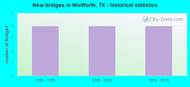
- New bridges - historical statistics
- 41990-1999
- 42000-2009
- 42010-2019


- Bridge Condition - Superstructure
- 33.3%Very good
- 50.0%Good
- 16.7%Satisfactory
Find on map >> Show street view
Structure Number: 51520038001016, Location: 3.90 MI SW OF SW LP 289 (Lat: 33.519375, Lng: -101.993975), Route carried "on" structure: US 62, Year Built: 1999, Status: Open, Structure Length: 12.13m (39.80ft), Average Daily Traffic: 8,227 (year 2020), Truck Traffic: 12%, Average Future Daily Traffic: 8,740 (year 2033), Design Load: HS 20, Features Intersected: 82ND ST
Minimum Vertical Clearance: 30+ m (98+ ft), Kilometerpoint: 11.628, Lanes on structure: 2, Lanes under structure: 7, Owner: State Highway Agency, Approaching Roadway Width: 12.2m (40.0ft), Skew: 4 degrees, Material/Design: Prestressed concrete, Design/Construction: Stringer/Multi-beam, Number Of Spans In Main Unit: 3, Length of Maximum Span: 42.1m (138.1ft), Curb-To-Curb Width: 12.0m (39.4ft), Out-to-Out Width: 12.8m (42.0ft)
Condition: Deck: Good, Superstructure: Good, Substructure: Good, Operating Rating: 54.4 metric tons, Method Used To Determine Operating Rating: Assigned rating based on Load Factor Design (LFD) reported in metric tons, Inventory Rating: 32.7 metric tons, Method Used To Determine Inventory Rating: Assigned rating based on Load Factor Design (LFD) reported in metric tons, Structural Evaluation: Better than present minimum criteria, Deck Geometry: Equal to present minimum criteria, Underclear: Somewhat better than minimum adequacy, Approach Roadway Alignment: Equal to present desirable criteria, Designated Inspection Frequency: Every 24 months, Inspection Date: September 2021, Deck Structure Type: Concrete Precast Panels
Find on map >> Show street view
Structure Number: 51520038001017, Location: 3.90 MI SW OF SW LP 289 (Lat: 33.520069, Lng: -101.993542), Route carried "on" structure: US 62, Year Built: 1999, Status: Open, Structure Length: 12.13m (39.80ft), Average Daily Traffic: 5,957 (year 2020), Truck Traffic: 12%, Average Future Daily Traffic: 8,740 (year 2033), Design Load: HS 20, Features Intersected: 82ND ST
Minimum Vertical Clearance: 30+ m (98+ ft), Kilometerpoint: 11.611, Lanes on structure: 2, Lanes under structure: 7, Owner: State Highway Agency, Approaching Roadway Width: 12.2m (40.0ft), Skew: 4 degrees, Material/Design: Prestressed concrete, Design/Construction: Stringer/Multi-beam, Number Of Spans In Main Unit: 3, Length of Maximum Span: 42.1m (138.1ft), Curb-To-Curb Width: 12.0m (39.4ft), Out-to-Out Width: 12.8m (42.0ft)
Condition: Deck: Good, Superstructure: Good, Substructure: Good, Operating Rating: 54.4 metric tons, Method Used To Determine Operating Rating: Assigned rating based on Load Factor Design (LFD) reported in metric tons, Inventory Rating: 32.7 metric tons, Method Used To Determine Inventory Rating: Assigned rating based on Load Factor Design (LFD) reported in metric tons, Structural Evaluation: Better than present minimum criteria, Deck Geometry: Equal to present minimum criteria, Underclear: Somewhat better than minimum adequacy, Approach Roadway Alignment: Equal to present desirable criteria, Designated Inspection Frequency: Every 24 months, Inspection Date: September 2021, Deck Structure Type: Concrete Precast Panels
Find on map >> Show street view
Structure Number: 51520038001018, Location: 5.45 MI SW OF SW LP 289 (Lat: 33.502467, Lng: -102.008711), Route carried "on" structure: US 62, Year Built: 2001, Status: Open, Structure Length: 6.40m (21.00ft), Average Daily Traffic: 5,957 (year 2020), Truck Traffic: 5%, Average Future Daily Traffic: 8,000 (year 2033), Design Load: HS 20, Features Intersected: FM 179
Minimum Vertical Clearance: 30+ m (98+ ft), Kilometerpoint: 9.012, Lanes on structure: 2, Lanes under structure: 6, Owner: State Highway Agency, Approaching Roadway Width: 11.3m (37.1ft), Skew: 2 degrees, Material/Design: Prestressed concrete, Design/Construction: Stringer/Multi-beam, Number Of Spans In Main Unit: 1, Number Of Approach Spans: 2, Length of Maximum Span: 29.0m (95.1ft), Curb-To-Curb Width: 11.1m (36.4ft), Out-to-Out Width: 12.0m (39.4ft)
Condition: Deck: Good, Superstructure: Satisfactory, Substructure: Good, Operating Rating: 54.4 metric tons, Method Used To Determine Operating Rating: Assigned rating based on Load Factor Design (LFD) reported in metric tons, Inventory Rating: 32.7 metric tons, Method Used To Determine Inventory Rating: Assigned rating based on Load Factor Design (LFD) reported in metric tons, Structural Evaluation: Equal to present minimum criteria, Deck Geometry: Equal to present minimum criteria, Underclear: Superior to present desirable criteria, Approach Roadway Alignment: Equal to present desirable criteria, Designated Inspection Frequency: Every 24 months, Inspection Date: September 2021, Deck Structure Type: Concrete Cast-file-Place
Find on map >> Show street view
Structure Number: 51520038001019, Location: 5.45 MI SW OF SW LP 289 (Lat: 33.501897, Lng: -102.009261), Route carried "on" structure: US 62, Year Built: 2001, Status: Open, Structure Length: 6.40m (21.00ft), Average Daily Traffic: 8,227 (year 2020), Truck Traffic: 5%, Average Future Daily Traffic: 8,000 (year 2033), Design Load: HS 20, Features Intersected: FM 179
Minimum Vertical Clearance: 30+ m (98+ ft), Kilometerpoint: 9.012, Lanes on structure: 2, Lanes under structure: 6, Owner: State Highway Agency, Approaching Roadway Width: 11.3m (37.1ft), Skew: 2 degrees, Material/Design: Prestressed concrete, Design/Construction: Stringer/Multi-beam, Number Of Spans In Main Unit: 1, Number Of Approach Spans: 2, Length of Maximum Span: 29.0m (95.1ft), Curb-To-Curb Width: 11.1m (36.4ft), Out-to-Out Width: 12.0m (39.4ft)
Condition: Deck: Good, Superstructure: Good, Substructure: Good, Operating Rating: 54.4 metric tons, Method Used To Determine Operating Rating: Assigned rating based on Load Factor Design (LFD) reported in metric tons, Inventory Rating: 32.7 metric tons, Method Used To Determine Inventory Rating: Assigned rating based on Load Factor Design (LFD) reported in metric tons, Structural Evaluation: Better than present minimum criteria, Deck Geometry: Equal to present minimum criteria, Underclear: Superior to present desirable criteria, Approach Roadway Alignment: Equal to present desirable criteria, Designated Inspection Frequency: Every 24 months, Inspection Date: September 2021, Deck Structure Type: Concrete Cast-file-Place
Find on map >> Show street view
Structure Number: 51520038001236, Location: 6.24 MI SW OF LOOP 289 (Lat: 33.499031, Lng: -102.026369), Route carried "on" structure: US 62, Year Built: 2017, Status: Open, Structure Length: 5.94m (19.49ft), Average Daily Traffic: 6,490 (year 2020), Truck Traffic: 9%, Average Future Daily Traffic: 11,895 (year 2035), Design Load: HL 93, Features Intersected: S LOOP 193
Minimum Vertical Clearance: 30+ m (98+ ft), Kilometerpoint: 7.549, Lanes on structure: 2, Lanes under structure: 5, Base Highway Network: Yes, Owner: State Highway Agency, Approaching Roadway Width: 11.6m (38.1ft), Skew: 1 degrees, Material/Design: Prestressed concrete, Design/Construction: Stringer/Multi-beam, Number Of Spans In Main Unit: 1, Number Of Approach Spans: 2, Length of Maximum Span: 29.0m (95.1ft), Curb-To-Curb Width: 11.3m (37.1ft), Out-to-Out Width: 12.2m (40.0ft)
Condition: Deck: Good, Superstructure: Very good, Substructure: Good, Operating Rating: 54.4 metric tons, Method Used To Determine Operating Rating: Assigned ratings based on Load and Resistance Factor Design (LRFD) reported in metric tons, Inventory Rating: 32.7 metric tons, Method Used To Determine Inventory Rating: Assigned ratings based on Load and Resistance Factor Design (LRFD) reported in metric tons, Structural Evaluation: Better than present minimum criteria, Deck Geometry: Somewhat better than minimum adequacy, Underclear: Equal to present minimum criteria, Approach Roadway Alignment: Equal to present desirable criteria, Designated Inspection Frequency: Every 24 months, Inspection Date: July 2021, Deck Structure Type: Concrete Precast Panels
Find on map >> Show street view
Structure Number: 51520038001237, Location: 6.24 MI SW OF LOOP 289 (Lat: 33.499289, Lng: -102.026389), Route carried "on" structure: US 62, Year Built: 2017, Status: Open, Structure Length: 5.94m (19.49ft), Average Daily Traffic: 7,073 (year 2019), Truck Traffic: 9%, Average Future Daily Traffic: 23,790 (year 2035), Design Load: HL 93, Features Intersected: S LOOP 193
Minimum Vertical Clearance: 30+ m (98+ ft), Kilometerpoint: 7.549, Lanes on structure: 2, Lanes under structure: 5, Base Highway Network: Yes, Owner: State Highway Agency, Approaching Roadway Width: 11.6m (38.1ft), Skew: 1 degrees, Material/Design: Prestressed concrete, Design/Construction: Stringer/Multi-beam, Number Of Spans In Main Unit: 1, Number Of Approach Spans: 2, Length of Maximum Span: 29.0m (95.1ft), Curb-To-Curb Width: 11.3m (37.1ft), Out-to-Out Width: 12.2m (40.0ft)
Condition: Deck: Good, Superstructure: Very good, Substructure: Good, Operating Rating: 54.4 metric tons, Method Used To Determine Operating Rating: Assigned ratings based on Load and Resistance Factor Design (LRFD) reported in metric tons, Inventory Rating: 32.7 metric tons, Method Used To Determine Inventory Rating: Assigned ratings based on Load and Resistance Factor Design (LRFD) reported in metric tons, Structural Evaluation: Better than present minimum criteria, Deck Geometry: Somewhat better than minimum adequacy, Underclear: Equal to present minimum criteria, Approach Roadway Alignment: Equal to present desirable criteria, Designated Inspection Frequency: Every 24 months, Inspection Date: July 2021, Deck Structure Type: Concrete Precast Panels
Find on map >> Show street view
Structure Number: 51520038001016, Location: 3.90 MI SW OF SW LP 289 (Lat: 33.519400, Lng: -101.994300), Route carried "under" structure: City street 82, Year Built: 1999, Structure Length: 0. m, Average Daily Traffic: 6,500 (year 2012), Truck Traffic: 5%, Features Intersected: 82ND ST
Minimum Vertical Clearance: 5.44m (17.85ft), Kilometerpoint: 7.854, Lanes on structure: 2, Lanes under structure: 7, Material/Design: Prestressed concrete, Design/Construction: Stringer/Multi-beam, Length of Maximum Span: 42.1m (138.1ft)
Find on map >> Show street view
Structure Number: 51520038001017, Location: 3.90 MI SW OF SW LP 289 (Lat: 33.520069, Lng: -101.993542), Route carried "under" structure: City street 82, Year Built: 1999, Structure Length: 0. m, Average Daily Traffic: 6,500 (year 2012), Truck Traffic: 5%, Features Intersected: 82ND ST
Minimum Vertical Clearance: 5.44m (17.85ft), Kilometerpoint: 7.854, Lanes on structure: 7, Material/Design: Prestressed concrete, Design/Construction: Stringer/Multi-beam, Length of Maximum Span: 42.1m (138.1ft)
Find on map >> Show street view
Structure Number: 51520038001018, Location: 5.45 MI SW OF SW LP 289 (Lat: 33.502100, Lng: -102.009300), Route carried "under" structure: State highway 179, Year Built: 2001, Structure Length: 0. m, Average Daily Traffic: 5,400 (year 2013), Truck Traffic: 5%, Features Intersected: FM 179, Facility Carried by Structure: US 62/82 WB
Minimum Vertical Clearance: 5.18m (16.99ft), Kilometerpoint: 12.875, Lanes on structure: 6, Material/Design: Prestressed concrete, Design/Construction: Stringer/Multi-beam, Length of Maximum Span: 29.0m (95.1ft)
Find on map >> Show street view
Structure Number: 51520038001019, Location: 5.45 MI SW OF SW LP 289 (Lat: 33.501800, Lng: -102.009300), Route carried "under" structure: State highway 179, Year Built: 2001, Structure Length: 0. m, Average Daily Traffic: 5,400 (year 2013), Truck Traffic: 5%, Features Intersected: FM 179, Facility Carried by Structure: US 62/82 EB
Minimum Vertical Clearance: 5.49m (18.01ft), Kilometerpoint: 12.875, Lanes on structure: 6, Material/Design: Prestressed concrete, Design/Construction: Stringer/Multi-beam, Length of Maximum Span: 29.0m (95.1ft)
Find on map >> Show street view
Structure Number: 51520038001236, Location: 6.24 MI SW OF LOOP 289 (Lat: 33.499200, Lng: -102.026300), Route carried "under" structure: State highway 193, Year Built: 2017, Structure Length: 0. m, Average Daily Traffic: 663 (year 2015), Truck Traffic: 65%, Features Intersected: S LOOP 193, Facility Carried by Structure: US 62 / 82 EB
Minimum Vertical Clearance: 5.21m (17.09ft), Kilometerpoint: 1.670, Lanes on structure: 5, Material/Design: Prestressed concrete, Design/Construction: Stringer/Multi-beam, Length of Maximum Span: 29.0m (95.1ft)
Find on map >> Show street view
Structure Number: 51520038001237, Location: 6.24 MI SW OF LOOP 289 (Lat: 33.499200, Lng: -102.026300), Route carried "under" structure: State highway 193, Year Built: 2017, Structure Length: 0. m, Average Daily Traffic: 663 (year 2015), Truck Traffic: 65%, Features Intersected: S LOOP 193, Facility Carried by Structure: US 62 / 82 WB
Minimum Vertical Clearance: 5.21m (17.09ft), Kilometerpoint: 1.670, Lanes on structure: 5, Material/Design: Prestressed concrete, Design/Construction: Stringer/Multi-beam, Length of Maximum Span: 29.0m (95.1ft)