Bridge Statistics for Woodside, California (CA)
Condition, Traffic, Stress, Structural Evaluation, Project Costs
- National Bridge Inventory (NBI) Statistics
- 22Number of bridges
- 138ft / 42.4mTotal length
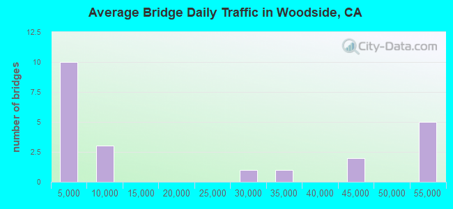
- 446,281Total average daily traffic
- 13,278Total average daily truck traffic
- National Bridge Inventory (NBI) Registered Bridges for Woodside
- No street view available for this location
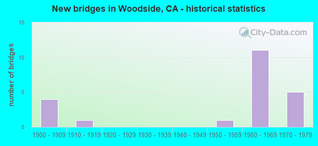
- New bridges - historical statistics
- 41900-1909
- 11910-1919
- 11950-1959
- 111960-1969
- 51970-1979
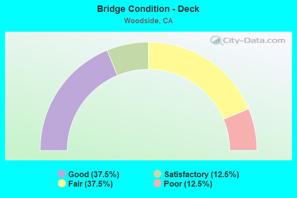
- Bridge Condition - Deck
- 37.5%Good
- 12.5%Satisfactory
- 37.5%Fair
- 12.5%Poor
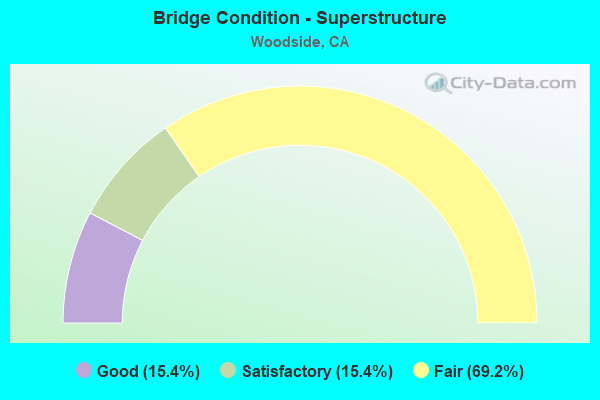
- Bridge Condition - Superstructure
- 15.4%Good
- 15.4%Satisfactory
- 69.2%Fair
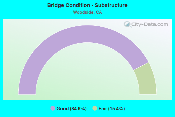
- Bridge Condition - Substructure
- 84.6%Good
- 15.4%Fair
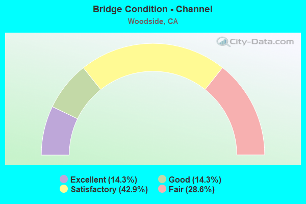
- Bridge Condition - Channel
- 14.3%Excellent
- 14.3%Good
- 42.9%Satisfactory
- 28.6%Fair
Find on map >> Show street view
Structure Number: 35 0044, Location: 04-SM-084-19.89-WDS (Lat: 37.425250, Lng: -122.267192), Route carried "on" structure: State highway 84, Year Built: 1903, Status: Open, Structure Length: 0.70m (2.30ft), Average Daily Traffic: 6,600 (year 2005), Truck Traffic: 2%, Average Future Daily Traffic: 25,561 (year 2037), Features Intersected: WEST UNION CREEK
Minimum Vertical Clearance: 30+ m (98+ ft), Kilometerpoint: 19.890, Lanes on structure: 2, Owner: State Highway Agency, Approaching Roadway Width: 5.8m (19.0ft), Material/Design: Concrete, Design/Construction: Arch - Deck, Number Of Spans In Main Unit: 1, Length of Maximum Span: 6.1m (20.0ft), Curb-To-Curb Width: 6.1m (20.0ft), Out-to-Out Width: 6.7m (22.0ft)
Condition: Superstructure: Fair, Substructure: Fair, Channel: Good, Operating Rating: 27.2 metric tons, Method Used To Determine Operating Rating: Field evaluation and documented engineering judgment, Inventory Rating: 16.2 metric tons, Method Used To Determine Inventory Rating: Field evaluation and documented engineering judgment, Structural Evaluation: Meets minimum limits, Deck Geometry: High priority of replacement, Waterway Adequacy: Equal to present minimum criteria, Approach Roadway Alignment: Equal to present minimum criteria, Designated Inspection Frequency: Every 24 months, Inspection Date: May 2020
Find on map >> Show street view
Structure Number: 35 0230R, Location: 04-SM-280-R4.65-WDS (Lat: 37.444078, Lng: -122.262767), Route carried "on" structure: Interstate 280, Year Built: 1969, Status: Open, Structure Length: 7.95m (26.08ft), Average Daily Traffic: 44,500 (year 2009), Truck Traffic: 3%, Average Future Daily Traffic: 76,002 (year 2038), Design Load: HS 20, Features Intersected: FARM HILL BOULEVARD
Minimum Vertical Clearance: 30+ m (98+ ft), Kilometerpoint: 4.650, Lanes on structure: 4, Lanes under structure: 4, Base Highway Network: Yes (Inventory Route: 2, Subroute: 1), Owner: State Highway Agency, Approaching Roadway Width: 20.1m (65.9ft), Skew: 5 degrees, Material/Design: Concrete continuous, Design/Construction: Box Beam or Girders - Multiple, Number Of Spans In Main Unit: 2, Length of Maximum Span: 41.3m (135.5ft), Curb-To-Curb Width: 20.1m (65.9ft), Out-to-Out Width: 21.2m (69.6ft)
Condition: Deck: Poor, Superstructure: Fair, Substructure: Good, Operating Rating: 83.6 metric tons, Method Used To Determine Operating Rating: Load Factor (LF), Inventory Rating: 49.9 metric tons, Method Used To Determine Inventory Rating: Load Factor (LF), Structural Evaluation: Somewhat better than minimum adequacy, Deck Geometry: Equal to present minimum criteria, Underclear: Somewhat better than minimum adequacy, Approach Roadway Alignment: Equal to present desirable criteria, Designated Inspection Frequency: Every 24 months, Inspection Date: October 2021, Deck Structure Type: Concrete Cast-file-Place
Find on map >> Show street view
Structure Number: 35 0231L, Location: 04-SM-280-R4.99-WDS (Lat: 37.444342, Lng: -122.269111), Route carried "on" structure: Interstate 280, Year Built: 1969, Status: Open, Structure Length: 5.34m (17.52ft), Average Daily Traffic: 50,000 (year 2009), Truck Traffic: 3%, Average Future Daily Traffic: 67,586 (year 2038), Design Load: HS 20, Features Intersected: CANADA ROAD
Minimum Vertical Clearance: 30+ m (98+ ft), Kilometerpoint: 4.990, Lanes on structure: 4, Lanes under structure: 2, Base Highway Network: Yes (Inventory Route: 2, Subroute: 1), Owner: State Highway Agency, Approaching Roadway Width: 20.1m (65.9ft), Skew: 4 degrees, Material/Design: Prestressed concrete, Design/Construction: Box Beam or Girders - Multiple, Number Of Spans In Main Unit: 1, Length of Maximum Span: 52.7m (172.9ft), Curb-To-Curb Width: 20.1m (65.9ft), Out-to-Out Width: 21.2m (69.6ft)
Condition: Deck: Fair, Superstructure: Fair, Substructure: Good, Operating Rating: 94.0 metric tons, Method Used To Determine Operating Rating: Load Factor (LF), Inventory Rating: 32.4 metric tons, Method Used To Determine Inventory Rating: Load Factor (LF), Structural Evaluation: Somewhat better than minimum adequacy, Deck Geometry: Equal to present minimum criteria, Underclear: Better than present minimum criteria, Approach Roadway Alignment: Equal to present desirable criteria, Designated Inspection Frequency: Every 24 months, Inspection Date: October 2021, Deck Structure Type: Concrete Cast-file-Place
Find on map >> Show street view
Structure Number: 35 0231R, Location: 04-SM-280-R4.99-WDS (Lat: 37.444678, Lng: -122.269283), Route carried "on" structure: Interstate 280, Year Built: 1969, Status: Open, Structure Length: 5.43m (17.81ft), Average Daily Traffic: 44,500 (year 2009), Truck Traffic: 3%, Average Future Daily Traffic: 77,536 (year 2038), Design Load: HS 20, Features Intersected: CANADA ROAD
Minimum Vertical Clearance: 30+ m (98+ ft), Kilometerpoint: 4.990, Lanes on structure: 4, Lanes under structure: 2, Base Highway Network: Yes (Inventory Route: 2, Subroute: 1), Owner: State Highway Agency, Approaching Roadway Width: 20.1m (65.9ft), Skew: 4 degrees, Material/Design: Prestressed concrete, Design/Construction: Box Beam or Girders - Multiple, Number Of Spans In Main Unit: 1, Length of Maximum Span: 53.5m (175.5ft), Curb-To-Curb Width: 20.1m (65.9ft), Out-to-Out Width: 21.2m (69.6ft)
Condition: Deck: Fair, Superstructure: Fair, Substructure: Good, Operating Rating: 95.9 metric tons, Method Used To Determine Operating Rating: Load Factor (LF), Inventory Rating: 32.4 metric tons, Method Used To Determine Inventory Rating: Load Factor (LF), Structural Evaluation: Somewhat better than minimum adequacy, Deck Geometry: Equal to present minimum criteria, Underclear: Better than present minimum criteria, Approach Roadway Alignment: Equal to present desirable criteria, Designated Inspection Frequency: Every 24 months, Inspection Date: October 2021, Deck Structure Type: Concrete Cast-file-Place
Find on map >> Show street view
Structure Number: 35 0232L, Location: 04-SM-280-R3.32-WDS (Lat: 37.435178, Lng: -122.243117), Route carried "on" structure: Interstate 280, Year Built: 1969, Status: Open, Structure Length: 4.82m (15.81ft), Average Daily Traffic: 50,500 (year 2009), Truck Traffic: 3%, Average Future Daily Traffic: 68,555 (year 2038), Design Load: HS 20, Features Intersected: SR 84 (WOODSIDE EXP)
Minimum Vertical Clearance: 30+ m (98+ ft), Kilometerpoint: 3.320, Lanes on structure: 4, Lanes under structure: 6, Base Highway Network: Yes (Inventory Route: 2, Subroute: 1), Owner: State Highway Agency, Approaching Roadway Width: 20.1m (65.9ft), Skew: 1 degrees, Material/Design: Prestressed concrete, Design/Construction: Box Beam or Girders - Multiple, Number Of Spans In Main Unit: 1, Length of Maximum Span: 47.3m (155.2ft), Curb-To-Curb Width: 20.1m (65.9ft), Out-to-Out Width: 21.2m (69.6ft)
Condition: Deck: Satisfactory, Superstructure: Fair, Substructure: Good, Operating Rating: 99.8 metric tons, Method Used To Determine Operating Rating: Load Factor (LF), Inventory Rating: 32.4 metric tons, Method Used To Determine Inventory Rating: Load Factor (LF), Structural Evaluation: Somewhat better than minimum adequacy, Deck Geometry: Equal to present minimum criteria, Underclear: Meets minimum limits, Approach Roadway Alignment: Equal to present desirable criteria, Designated Inspection Frequency: Every 24 months, Inspection Date: October 2021, Deck Structure Type: Concrete Cast-file-Place
Find on map >> Show street view
Structure Number: 35 0232R, Location: 04-SM-280-R3.32-WDS (Lat: 37.435306, Lng: -122.242844), Route carried "on" structure: Interstate 280, Year Built: 1969, Status: Open, Structure Length: 4.82m (15.81ft), Average Daily Traffic: 50,500 (year 2009), Truck Traffic: 3%, Average Future Daily Traffic: 169,818 (year 2038), Design Load: HS 20, Features Intersected: SR 84 (WOODSIDE EXP)
Minimum Vertical Clearance: 30+ m (98+ ft), Kilometerpoint: 3.320, Lanes on structure: 4, Lanes under structure: 6, Base Highway Network: Yes (Inventory Route: 2, Subroute: 1), Owner: State Highway Agency, Approaching Roadway Width: 20.1m (65.9ft), Skew: 1 degrees, Material/Design: Prestressed concrete, Design/Construction: Box Beam or Girders - Multiple, Number Of Spans In Main Unit: 1, Length of Maximum Span: 47.2m (154.9ft), Curb-To-Curb Width: 20.1m (65.9ft), Out-to-Out Width: 21.2m (69.6ft)
Condition: Deck: Fair, Superstructure: Good, Substructure: Good, Operating Rating: 99.8 metric tons, Method Used To Determine Operating Rating: Load Factor (LF), Inventory Rating: 32.4 metric tons, Method Used To Determine Inventory Rating: Load Factor (LF), Structural Evaluation: Better than present minimum criteria, Deck Geometry: Equal to present minimum criteria, Underclear: Meets minimum limits, Approach Roadway Alignment: Equal to present desirable criteria, Designated Inspection Frequency: Every 24 months, Inspection Date: October 2021, Deck Structure Type: Concrete Cast-file-Place
Find on map >> Show street view
Structure Number: 35 0276L, Location: 04-SM-280-R6.60 (Lat: 37.459919, Lng: -122.290431), Route carried "on" structure: Interstate 280, Year Built: 1973, Status: Open, Structure Length: 4.14m (13.58ft), Average Daily Traffic: 50,000 (year 2009), Truck Traffic: 3%, Average Future Daily Traffic: 67,280 (year 2038), Design Load: HS 20, Features Intersected: CANADA ROAD
Minimum Vertical Clearance: 30+ m (98+ ft), Kilometerpoint: 6.600, Lanes on structure: 4, Lanes under structure: 3, Base Highway Network: Yes (Inventory Route: 2, Subroute: 1), Owner: State Highway Agency, Approaching Roadway Width: 20.1m (65.9ft), Skew: 2 degrees, Material/Design: Prestressed concrete, Design/Construction: Box Beam or Girders - Multiple, Number Of Spans In Main Unit: 1, Length of Maximum Span: 40.7m (133.5ft), Curb-To-Curb Width: 20.1m (65.9ft), Out-to-Out Width: 21.2m (69.6ft)
Condition: Deck: Good, Superstructure: Satisfactory, Substructure: Good, Operating Rating: 99.8 metric tons, Method Used To Determine Operating Rating: Load Factor (LF), Inventory Rating: 32.4 metric tons, Method Used To Determine Inventory Rating: Load Factor (LF), Structural Evaluation: Equal to present minimum criteria, Deck Geometry: Equal to present minimum criteria, Underclear: Meets minimum limits, Approach Roadway Alignment: Equal to present desirable criteria, Designated Inspection Frequency: Every 24 months, Inspection Date: October 2021, Deck Structure Type: Concrete Cast-file-Place
Find on map >> Show street view
Structure Number: 35 0276R, Location: 04-SM-280-R6.60 (Lat: 37.459822, Lng: -122.290011), Route carried "on" structure: Interstate 280, Year Built: 1973, Status: Open, Structure Length: 4.21m (13.81ft), Average Daily Traffic: 50,000 (year 2009), Truck Traffic: 3%, Average Future Daily Traffic: 169,818 (year 2038), Design Load: HS 20, Features Intersected: CANADA ROAD
Minimum Vertical Clearance: 30+ m (98+ ft), Kilometerpoint: 6.600, Lanes on structure: 5, Lanes under structure: 2, Base Highway Network: Yes (Inventory Route: 2, Subroute: 1), Owner: State Highway Agency, Approaching Roadway Width: 23.2m (76.1ft), Skew: 4 degrees, Material/Design: Prestressed concrete, Design/Construction: Box Beam or Girders - Multiple, Number Of Spans In Main Unit: 1, Length of Maximum Span: 41.3m (135.5ft), Curb-To-Curb Width: 23.2m (76.1ft), Out-to-Out Width: 24.3m (79.7ft)
Condition: Deck: Good, Superstructure: Satisfactory, Substructure: Good, Operating Rating: 99.8 metric tons, Method Used To Determine Operating Rating: Load Factor (LF), Inventory Rating: 32.4 metric tons, Method Used To Determine Inventory Rating: Load Factor (LF), Structural Evaluation: Equal to present minimum criteria, Deck Geometry: Somewhat better than minimum adequacy, Underclear: Meets minimum limits, Approach Roadway Alignment: Equal to present desirable criteria, Designated Inspection Frequency: Every 24 months, Inspection Date: October 2021, Deck Structure Type: Concrete Cast-file-Place
Find on map >> Show street view
Structure Number: 35C005, Location: NORTH OF 'F' ST (Lat: 37.494319, Lng: -122.244139), Route carried "on" structure: City street , Year Built: 1903, Status: Open, Structure Length: 0.85m (2.79ft), Average Daily Traffic: 5,000 (year 2010), Truck Traffic: 15%, Average Future Daily Traffic: 10,582 (year 2040), Features Intersected: CORDILLERAS CREEK, Facility Carried by Structure: STAFFORD ST
Minimum Vertical Clearance: 30+ m (98+ ft), Kilometerpoint: 0.000, Lanes on structure: 2, Base Highway Network: Yes, Owner: City or Municipal Highway Agency, Approaching Roadway Width: 14.0m (45.9ft), Skew: 3 degrees, Material/Design: Concrete, Design/Construction: Arch - Deck, Number Of Spans In Main Unit: 1, Length of Maximum Span: 7.9m (25.9ft), Curb-To-Curb Width: 8.8m (28.9ft), Out-to-Out Width: 9.9m (32.5ft)
Condition: Superstructure: Fair, Substructure: Good, Channel: Satisfactory, Operating Rating: 27.5 metric tons, Method Used To Determine Operating Rating: Field evaluation and documented engineering judgment, Inventory Rating: 16.5 metric tons, Method Used To Determine Inventory Rating: Field evaluation and documented engineering judgment, Structural Evaluation: Meets minimum limits, Deck Geometry: Meets minimum limits, Waterway Adequacy: Better than present minimum criteria, Approach Roadway Alignment: Equal to present minimum criteria, Designated Inspection Frequency: Every 24 months, Inspection Date: April 2020
Find on map >> Show street view
Structure Number: 35C0055, Location: 0.25 MI E OF SH 84 (Lat: 37.404300, Lng: -122.254564), Route carried "on" structure: City street , Year Built: 1914, Status: Open, Structure Length: 0.79m (2.59ft), Average Daily Traffic: 2,969 (year 2019), Truck Traffic: 1%, Average Future Daily Traffic: 6,307 (year 2040), Features Intersected: ALEMBIQUE CREEK, Facility Carried by Structure: PORTOLA RD
Minimum Vertical Clearance: 30+ m (98+ ft), Kilometerpoint: 0.000, Lanes on structure: 2, Owner: City or Municipal Highway Agency, Approaching Roadway Width: 5.2m (17.1ft), Skew: 2 degrees, Material/Design: Concrete, Design/Construction: Tee Beam, Number Of Spans In Main Unit: 1, Length of Maximum Span: 7.6m (24.9ft), Curb or Sidewalk Widths: Left: 0.1m (0.3ft), Right: 0.1m (0.3ft), Curb-To-Curb Width: 6.5m (21.3ft), Out-to-Out Width: 6.7m (22.0ft)
Condition: Deck: Good, Superstructure: Fair, Substructure: Fair, Channel: Satisfactory, Operating Rating: 24.0 metric tons, Method Used To Determine Operating Rating: Load Factor (LF), Inventory Rating: 14.3 metric tons, Method Used To Determine Inventory Rating: Load Factor (LF), Structural Evaluation: Meets minimum limits, Deck Geometry: High priority of replacement, Waterway Adequacy: Equal to present minimum criteria, Approach Roadway Alignment: High priority of corrective action, Designated Inspection Frequency: Every 24 months, Inspection Date: May 2021, Deck Structure Type: Concrete Cast-file-Place, Wearing Surface/Protective System: Wearing Surface: Bituminous
Find on map >> Show street view
Structure Number: 35C0056, Location: SOUTH WHISKEY HILL RD (Lat: 37.411061, Lng: -122.241342), Route carried "on" structure: County highway , Year Built: 1950, Status: Open, Structure Length: 0.82m (2.69ft), Average Daily Traffic: 7,137 (year 2019), Truck Traffic: 6%, Average Future Daily Traffic: 12,614 (year 2040), Features Intersected: BEAR GULCH CREEK, Facility Carried by Structure: SAND HILL RD
Minimum Vertical Clearance: 30+ m (98+ ft), Kilometerpoint: 0.000, Lanes on structure: 2, Base Highway Network: Yes, Owner: County Highway Agency, Approaching Roadway Width: 12.2m (40.0ft), Skew: 3 degrees, Material/Design: Steel, Design/Construction: Arch - Deck, Number Of Spans In Main Unit: 1, Length of Maximum Span: 6.7m (22.0ft)
Condition: Superstructure: Fair, Substructure: Good, Channel: Fair, Operating Rating: 97.2 metric tons, Method Used To Determine Operating Rating: Load and Resistance Factor Rating (LRFR) rating reported by rating factor(RF) method using HL-93 loadings, Inventory Rating: 97.2 metric tons, Method Used To Determine Inventory Rating: Load and Resistance Factor Rating (LRFR) rating reported by rating factor(RF) method using HL-93 loadings, Structural Evaluation: Somewhat better than minimum adequacy, Waterway Adequacy: Equal to present minimum criteria, Approach Roadway Alignment: Equal to present desirable criteria, Designated Inspection Frequency: Every 24 months, Inspection Date: May 2021
Find on map >> Show street view
Structure Number: 35C0122, Location: 0.3 MI S OF S.H. 84 (Lat: 37.426592, Lng: -122.253392), Route carried "on" structure: City street , Year Built: 1900, Status: Open, Structure Length: 1.16m (3.81ft), Average Daily Traffic: 500 (year 2015), Truck Traffic: 1%, Average Future Daily Traffic: 417 (year 2040), Features Intersected: BEAR CREEK, Facility Carried by Structure: MOUNTAIN HOME RD
Minimum Vertical Clearance: 30+ m (98+ ft), Kilometerpoint: 0.000, Lanes on structure: 2, Owner: City or Municipal Highway Agency, Approaching Roadway Width: 5.2m (17.1ft), Material/Design: Concrete, Design/Construction: Arch - Deck, Number Of Spans In Main Unit: 1, Length of Maximum Span: 10.4m (34.1ft), Curb-To-Curb Width: 5.6m (18.4ft), Out-to-Out Width: 6.4m (21.0ft)
Condition: Superstructure: Fair, Substructure: Good, Channel: Satisfactory, Operating Rating: 25.9 metric tons, Method Used To Determine Operating Rating: Field evaluation and documented engineering judgment, Inventory Rating: 15.6 metric tons, Method Used To Determine Inventory Rating: Field evaluation and documented engineering judgment, Structural Evaluation: Meets minimum limits, Deck Geometry: High priority of replacement, Waterway Adequacy: Better than present minimum criteria, Approach Roadway Alignment: Equal to present minimum criteria, Designated Inspection Frequency: Every 24 months, Inspection Date: May 2021
Find on map >> Show street view
Structure Number: 35C0123, Location: 0.05 MI E TRIPP RD (Lat: 37.430694, Lng: -122.276225), Route carried "on" structure: City street , Year Built: 1905, Status: Open, Structure Length: 0.76m (2.49ft), Average Daily Traffic: 2,075 (year 2015), Truck Traffic: 1%, Average Future Daily Traffic: 3,154 (year 2040), Features Intersected: WEST UNION CREEK, Facility Carried by Structure: KINGS MOUNTAIN RD
Minimum Vertical Clearance: 30+ m (98+ ft), Kilometerpoint: 0.000, Lanes on structure: 2, Owner: City or Municipal Highway Agency, Approaching Roadway Width: 6.1m (20.0ft), Material/Design: Concrete, Design/Construction: Arch - Deck, Number Of Spans In Main Unit: 1, Length of Maximum Span: 6.7m (22.0ft), Curb-To-Curb Width: 5.9m (19.4ft), Out-to-Out Width: 6.7m (22.0ft)
Condition: Superstructure: Good, Substructure: Good, Channel: Fair, Operating Rating: 28.5 metric tons, Method Used To Determine Operating Rating: Field evaluation and documented engineering judgment, Inventory Rating: 17.2 metric tons, Method Used To Determine Inventory Rating: Field evaluation and documented engineering judgment, Structural Evaluation: Meets minimum limits, Deck Geometry: High priority of replacement, Waterway Adequacy: Better than present minimum criteria, Approach Roadway Alignment: Equal to present minimum criteria, Designated Inspection Frequency: Every 24 months, Inspection Date: May 2021
Find on map >> Show street view
Structure Number: 35C0191, Location: 500 FT S. OF SR 84 (Lat: 37.425422, Lng: -122.262531), Route carried "on" structure: City street , Year Built: 1975, Status: Open, Structure Length: 0.65m (2.13ft), Average Daily Traffic: 50 (year 2019), Truck Traffic: 1%, Average Future Daily Traffic: 62 (year 2040), Features Intersected: BEAR GULCH CREEK, Facility Carried by Structure: FOX HOLLOW ROAD
Minimum Vertical Clearance: 30+ m (98+ ft), Kilometerpoint: 0.000, Lanes on structure: 2, Owner: Town or Township Highway Agency, Approaching Roadway Width: 8.0m (26.2ft), Material/Design: Concrete continuous, Design/Construction: Culvert, Number Of Spans In Main Unit: 2, Length of Maximum Span: 3.2m (10.5ft)
Condition: Channel: Excellent, Culverts: Satisfactory, Operating Rating: 54.1 metric tons, Method Used To Determine Operating Rating: Field evaluation and documented engineering judgment, Inventory Rating: 32.4 metric tons, Method Used To Determine Inventory Rating: Field evaluation and documented engineering judgment, Structural Evaluation: Equal to present minimum criteria, Waterway Adequacy: Meets minimum limits, Approach Roadway Alignment: Equal to present desirable criteria, Designated Inspection Frequency: Every 24 months, Inspection Date: May 2021
Find on map >> Show street view
Structure Number: 35 0230L, Location: 04-SM-280-R4.65-WDS (Lat: 37.443697, Lng: -122.263236), Route carried "under" structure: City street D315, Year Built: 1969, Structure Length: 0. m, Average Daily Traffic: 3,700 (year 1998), Truck Traffic: 1%, Features Intersected: FARM HILL BOULEVARD, Facility Carried by Structure: INTERSTATE 280
Minimum Vertical Clearance: 5.33m (17.49ft), Kilometerpoint: 0.000, Lanes on structure: 4, Lanes under structure: 4, Material/Design: Concrete continuous, Design/Construction: Box Beam or Girders - Multiple, Length of Maximum Span: 37.1m (121.7ft)
Find on map >> Show street view
Structure Number: 35 0230R, Location: 04-SM-280-R4.65-WDS (Lat: 37.444078, Lng: -122.262767), Route carried "under" structure: City street D315, Year Built: 1969, Structure Length: 0. m, Average Daily Traffic: 3,700 (year 2009), Truck Traffic: 1%, Features Intersected: FARM HILL BOULEVARD, Facility Carried by Structure: INTERSTATE 280 NB
Minimum Vertical Clearance: 4.75m (15.58ft), Kilometerpoint: 0.000, Lanes on structure: 4, Lanes under structure: 4, Material/Design: Concrete continuous, Design/Construction: Box Beam or Girders - Multiple, Length of Maximum Span: 41.3m (135.5ft)
Find on map >> Show street view
Structure Number: 35 0231L, Location: 04-SM-280-R4.99-WDS (Lat: 37.444342, Lng: -122.269111), Route carried "under" structure: City street D309, Year Built: 1969, Structure Length: 0. m, Average Daily Traffic: 3,700 (year 1998), Truck Traffic: 1%, Features Intersected: CANADA ROAD, Facility Carried by Structure: INTERSTATE 280 SB
Minimum Vertical Clearance: 5.41m (17.75ft), Kilometerpoint: 0.000, Lanes on structure: 4, Lanes under structure: 2, Material/Design: Prestressed concrete, Design/Construction: Box Beam or Girders - Multiple, Length of Maximum Span: 52.7m (172.9ft)
Find on map >> Show street view
Structure Number: 35 0231R, Location: 04-SM-280-R4.99-WDS (Lat: 37.444678, Lng: -122.269283), Route carried "under" structure: City street D309, Year Built: 1969, Structure Length: 0. m, Average Daily Traffic: 3,700 (year 2009), Truck Traffic: 1%, Features Intersected: CANADA ROAD, Facility Carried by Structure: INTERSTATE 280 NB
Minimum Vertical Clearance: 4.95m (16.24ft), Kilometerpoint: 0.000, Lanes on structure: 4, Lanes under structure: 2, Material/Design: Prestressed concrete, Design/Construction: Box Beam or Girders - Multiple, Length of Maximum Span: 53.5m (175.5ft)
Find on map >> Show street view
Structure Number: 35 0232L, Location: 04-SM-280-R3.32-WDS (Lat: 37.435178, Lng: -122.243117), Route carried "under" structure: State highway 84, Year Built: 1969, Structure Length: 0. m, Average Daily Traffic: 29,750 (year 2009), Truck Traffic: 3%, Features Intersected: SR 84 (WOODSIDE EXP), Facility Carried by Structure: INTERSTATE 280 SB
Minimum Vertical Clearance: 4.57m (14.99ft), Kilometerpoint: 21.540, Lanes on structure: 4, Lanes under structure: 6, Material/Design: Prestressed concrete, Design/Construction: Box Beam or Girders - Multiple, Length of Maximum Span: 47.3m (155.2ft)
Find on map >> Show street view
Structure Number: 35 0232R, Location: 04-SM-280-R3.32-WDS (Lat: 37.435306, Lng: -122.242844), Route carried "under" structure: State highway 84, Year Built: 1969, Structure Length: 0. m, Average Daily Traffic: 30,000 (year 2009), Truck Traffic: 2%, Features Intersected: SR 84 (WOODSIDE EXP), Facility Carried by Structure: INTERSTATE 280 NB
Minimum Vertical Clearance: 5.74m (18.83ft), Kilometerpoint: 21.540, Lanes on structure: 4, Lanes under structure: 6, Material/Design: Prestressed concrete, Design/Construction: Box Beam or Girders - Multiple, Length of Maximum Span: 47.2m (154.9ft)
Find on map >> Show street view
Structure Number: 35 0276L, Location: 04-SM-280-R6.60 (Lat: 37.459919, Lng: -122.290431), Route carried "under" structure: County highway D309, Year Built: 1973, Structure Length: 0. m, Average Daily Traffic: 3,700 (year 1998), Truck Traffic: 1%, Features Intersected: CANADA ROAD, Facility Carried by Structure: INTERSTATE 280 SB
Minimum Vertical Clearance: 7.83m (25.69ft), Kilometerpoint: 0.000, Lanes on structure: 4, Lanes under structure: 3, Material/Design: Prestressed concrete, Design/Construction: Box Beam or Girders - Multiple, Length of Maximum Span: 40.7m (133.5ft)
Find on map >> Show street view
Structure Number: 35 0276R, Location: 04-SM-280-R6.60 (Lat: 37.459822, Lng: -122.290011), Route carried "under" structure: County highway D309, Year Built: 1973, Structure Length: 0. m, Average Daily Traffic: 3,700 (year 2009), Truck Traffic: 1%, Features Intersected: CANADA ROAD, Facility Carried by Structure: INTERSTATE 280 NB
Minimum Vertical Clearance: 5.79m (19.00ft), Kilometerpoint: 0.000, Lanes on structure: 5, Lanes under structure: 2, Material/Design: Prestressed concrete, Design/Construction: Box Beam or Girders - Multiple, Length of Maximum Span: 41.3m (135.5ft)