Abernant, Alabama

Submit your own pictures of this place and show them to the world
- OSM Map
- General Map
- Google Map
- MSN Map

| Males: 3,791 | |
| Females: 3,808 |
| Median resident age: | 34.3 years |
| Alabama median age: | 35.8 years |
Zip code: 35111
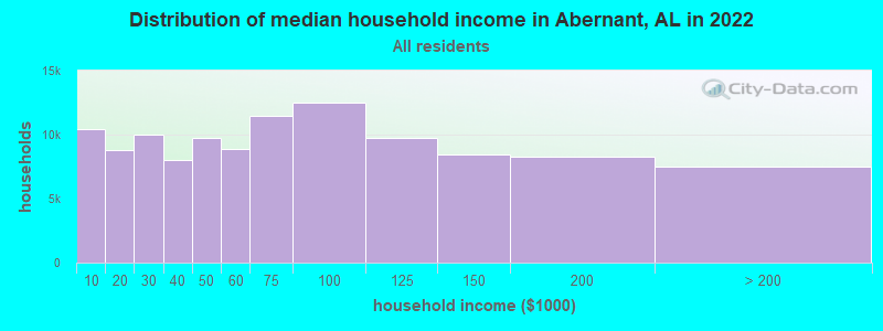
| Abernant: | $78,078 |
| AL: | $59,674 |
Estimated per capita income in 2022: $31,723 (it was $18,103 in 2000)
Abernant CCD income, earnings, and wages data
Estimated median house or condo value in 2022: $263,182 (it was $98,000 in 2000)
| Abernant: | $263,182 |
| AL: | $200,900 |
Mean prices in 2022: all housing units: $274,542; detached houses: $302,362; townhouses or other attached units: $210,995; in 2-unit structures: $86,470; in 3-to-4-unit structures: $67,951; in 5-or-more-unit structures: $151,988; mobile homes: $75,047; occupied boats, rvs, vans, etc.: $32,477
Detailed information about poverty and poor residents in Abernant, AL
Compare current foreclosures near Abernant, AL:
| Photo | Address | Area | Beds / Baths | Price | Details |
|---|---|---|---|---|---|

|
#1
Exeter Ave
Bessemer, AL 35020
|
1,140 sq. feet
|
1 baths 3 beds |
$20,000
|
show details |

|
#2
Camellia Ln
West Blocton, AL 35184
|
2,026 sq. feet
|
2 baths 3 beds |
$219,900
|
show details |

|
#3
Opal Ave
Bessemer, AL 35023
|
1,669 sq. feet
|
2 baths 3 beds |
$199,900
|
show details |

|
#4
19th St N
Bessemer, AL 35023
|
1,388 sq. feet
|
1 baths 3 beds |
show details | |

|
#5
27th St N
Bessemer, AL 35020
|
1,306 sq. feet
|
1 baths 3 beds |
show details | |

|
#6
Chestnut Ave
Bessemer, AL 35020
|
1,128 sq. feet
|
1 baths 3 beds |
show details | |

|
#7
Hueytown Rd
Bessemer, AL 35023
|
1,650 sq. feet
|
1 baths 3 beds |
show details | |

|
#8
Jeanne Ln
Bessemer, AL 35023
|
1,460 sq. feet
|
2 baths 3 beds |
show details | |

|
#9
Jeanne Ln
Bessemer, AL 35023
|
1,460 sq. feet
|
2 baths 3 beds |
show details | |

|
#10
Hielary Cir
Bessemer, AL 35023
|
1,441 sq. feet
|
2 baths 3 beds |
show details |
| Photo | Address | Area | Beds / Baths | Price | Details |
|---|---|---|---|---|---|

|
#11
Downing Dr
Mc Calla, AL 35111
|
- sq. feet
|
2 baths 3 beds |
show details | |

|
#12
Augusta Ln
Bessemer, AL 35022
|
2,876 sq. feet
|
2 baths 3 beds |
show details | |

|
#13
Longbrook Dr
Bessemer, AL 35020
|
1,182 sq. feet
|
2 baths 3 beds |
show details | |

|
#14
Victoria Dr
Bessemer, AL 35023
|
1,584 sq. feet
|
3 baths 4 beds |
show details | |

|
#15
Lee Ann Dr
Bessemer, AL 35023
|
1,767 sq. feet
|
3 baths 4 beds |
show details | |

|
#16
James Ave
Bessemer, AL 35023
|
1,435 sq. feet
|
2 baths 3 beds |
show details | |

|
#17
Shadow Lake Cir
Mc Calla, AL 35111
|
1,620 sq. feet
|
2 baths 3 beds |
show details | |

|
#18
Bloomery Way
Mc Calla, AL 35111
|
3,567 sq. feet
|
1 baths 5 beds |
show details | |

|
#19
Morris Ln
Mc Calla, AL 35111
|
1,788 sq. feet
|
2 baths 3 beds |
show details | |

|
#20
Owen Park Dr
Mc Calla, AL 35111
|
1,745 sq. feet
|
2 baths 3 beds |
show details |
| Photo | Address | Area | Beds / Baths | Price | Details |
|---|---|---|---|---|---|

|
#21
Forest Cir
Bessemer, AL 35023
|
1,293 sq. feet
|
2 baths 3 beds |
show details | |

|
#22
Old Cahaba Dr
Helena, AL 35080
|
1,778 sq. feet
|
2 baths 3 beds |
show details | |

|
#23
Mabelon Dr
Bessemer, AL 35023
|
1,248 sq. feet
|
1 baths 3 beds |
show details | |

|
#24
7th St S
Bessemer, AL 35020
|
1,376 sq. feet
|
1 baths 3 beds |
show details | |

|
#25
Oak Cir
Bessemer, AL 35023
|
2,094 sq. feet
|
2 baths 3 beds |
show details | |

|
#26
26th Ave N
Bessemer, AL 35023
|
884 sq. feet
|
2 baths 2 beds |
show details | |

|
#27
Headrick Rd
Bessemer, AL 35022
|
1,142 sq. feet
|
2 baths 3 beds |
show details | |

|
#28
Live Oaks Ln
Bessemer, AL 35023
|
1,756 sq. feet
|
2 baths 3 beds |
show details | |

|
#29
Red Bay Cv
Maylene, AL 35114
|
3,868 sq. feet
|
4 baths 5 beds |
show details | |

|
#30
Five Acre Rd
Bessemer, AL 35023
|
1,232 sq. feet
|
1 baths 3 beds |
show details |
| Photo | Address | Area | Beds / Baths | Price | Details |
|---|---|---|---|---|---|

|
#31
Woodland Rd
Bessemer, AL 35020
|
1,549 sq. feet
|
2 baths 2 beds |
show details | |

|
#32
Townley Way
Mc Calla, AL 35111
|
1,287 sq. feet
|
2 baths 2 beds |
show details | |

|
#33
Donna Circle
Bessemer, AL 35022
|
3,091 sq. feet
|
3 baths 5 beds |
show details | |

|
#34
Lake View Dr
Mc Calla, AL 35111
|
1,758 sq. feet
|
2 baths 3 beds |
show details | |

|
#35
Briarwood Dr
Bessemer, AL 35022
|
1,634 sq. feet
|
3 baths 5 beds |
show details | |

|
#36
Woodhighlands Dr
Birmingham, AL 35244
|
2,661 sq. feet
|
3 baths 4 beds |
show details | |

|
#37
18th Way N
Bessemer, AL 35020
|
973 sq. feet
|
1 baths 2 beds |
show details | |

|
#38
18th Way N
Bessemer, AL 35020
|
560 sq. feet
|
1 baths 2 beds |
show details | |

|
#39
12th Ave N
Bessemer, AL 35020
|
1,168 sq. feet
|
1 baths 3 beds |
show details | |

|
#40
Tinker St
Bessemer, AL 35023
|
1,563 sq. feet
|
2 baths 3 beds |
show details |
| Photo | Address | Area | Beds / Baths | Price | Details |
|---|---|---|---|---|---|

|
#41
Fairfax Ave
Bessemer, AL 35020
|
1,338 sq. feet
|
1 baths 3 beds |
show details | |

|
#42
14th Ave N
Bessemer, AL 35020
|
1,316 sq. feet
|
1 baths 3 beds |
show details | |

|
#43
6th Ave N
Bessemer, AL 35020
|
1,883 sq. feet
|
2 baths 3 beds |
show details | |

|
#44
4th Ave N
Bessemer, AL 35020
|
1,440 sq. feet
|
1 baths 3 beds |
show details | |

|
#45
21st St
Bessemer, AL 35023
|
1,204 sq. feet
|
1 baths 3 beds |
show details | |

|
#46
17th St N
Bessemer, AL 35020
|
1,040 sq. feet
|
1 baths 2 beds |
show details | |

|
#47
Willow Dr
Bessemer, AL 35023
|
1,055 sq. feet
|
1 baths 2 beds |
show details | |

|
#48
Granville Ave
Bessemer, AL 35020
|
3,582 sq. feet
|
2 baths 3 beds |
show details | |

|
#49
Longbrook Dr
Bessemer, AL 35020
|
2,191 sq. feet
|
2 baths 3 beds |
show details | |

|
Check over 1 million property listings on Foreclosure.com!
|
browse all offers | |||

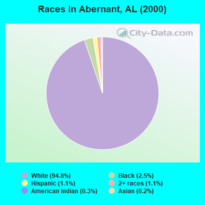
- 6,64794.8%White alone
- 1742.5%Black alone
- 761.1%Two or more races
- 801.1%Hispanic
- 230.3%American Indian alone
- 110.2%Asian alone
- 10.01%Native Hawaiian and Other
Pacific Islander alone - 10.01%Other race alone
 Recent articles from our blog. Our writers, many of them Ph.D. graduates or candidates, create easy-to-read articles on a wide variety of topics.
Current Local Time: CST time zone
Elevation: 466 feet
Land area: 51.7 square miles.
Population density: 147 people per square mile (very low).

| Abernant CCD: | 0.2% ($244) |
| Alabama: | 0.4% ($289) |
Nearest city with pop. 50,000+: Hoover, AL  (21.2 miles , pop. 62,742).
Nearest city with pop. 200,000+: Birmingham, AL (26.0 miles , pop. 242,820).
Nearest city with pop. 1,000,000+: Houston, TX (542.7 miles , pop. 1,953,631).
Nearest cities:
), ), ), ), ), ), )Latitude: 33.27 N, Longitude: 87.15 W
Area code commonly used in this area: 205

| Here: | 2.3% |
| Alabama: | 2.6% |
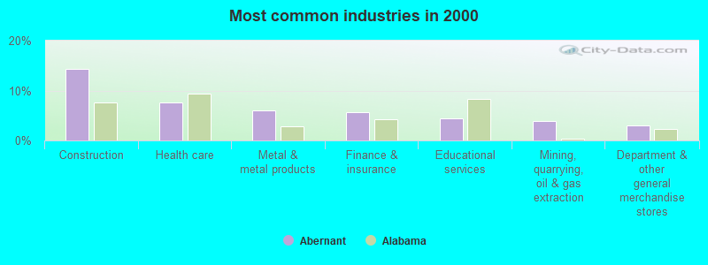
- Construction (14.4%)
- Health care (7.5%)
- Metal & metal products (6.0%)
- Finance & insurance (5.6%)
- Educational services (4.5%)
- Mining, quarrying, oil & gas extraction (3.8%)
- Department & other general merchandise stores (3.0%)
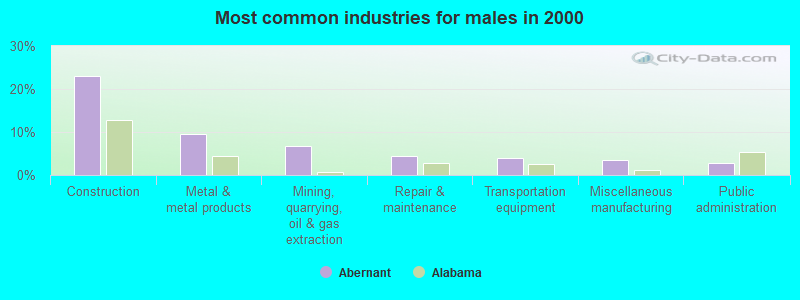
- Construction (23.0%)
- Metal & metal products (9.5%)
- Mining, quarrying, oil & gas extraction (6.7%)
- Repair & maintenance (4.4%)
- Transportation equipment (4.0%)
- Miscellaneous manufacturing (3.5%)
- Public administration (2.9%)
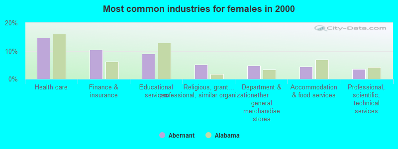
- Health care (14.8%)
- Finance & insurance (10.4%)
- Educational services (9.1%)
- Religious, grantmaking, civic, professional, similar organizations (5.1%)
- Department & other general merchandise stores (4.8%)
- Accommodation & food services (4.3%)
- Professional, scientific, technical services (3.6%)
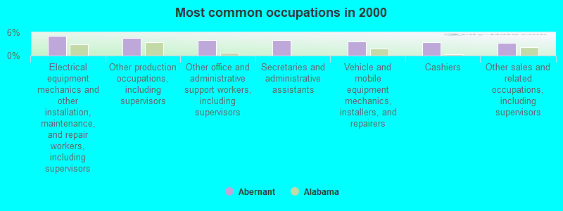
- Electrical equipment mechanics and other installation, maintenance, and repair workers, including supervisors (5.0%)
- Other production occupations, including supervisors (4.6%)
- Other office and administrative support workers, including supervisors (4.0%)
- Secretaries and administrative assistants (4.0%)
- Vehicle and mobile equipment mechanics, installers, and repairers (3.7%)
- Cashiers (3.5%)
- Other sales and related occupations, including supervisors (3.2%)
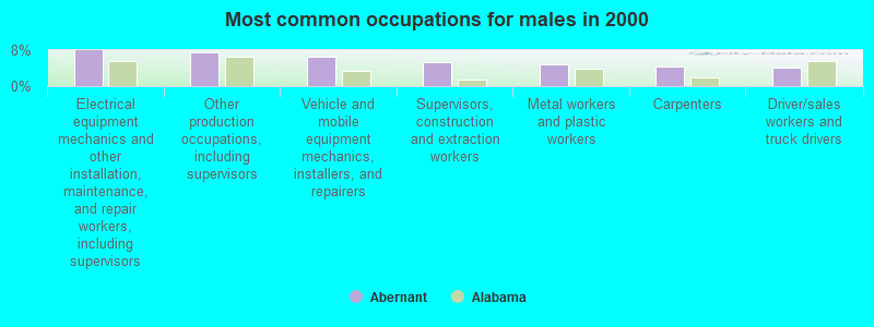
- Electrical equipment mechanics and other installation, maintenance, and repair workers, including supervisors (8.0%)
- Other production occupations, including supervisors (7.4%)
- Vehicle and mobile equipment mechanics, installers, and repairers (6.6%)
- Supervisors, construction and extraction workers (5.3%)
- Metal workers and plastic workers (4.8%)
- Carpenters (4.3%)
- Driver/sales workers and truck drivers (4.1%)
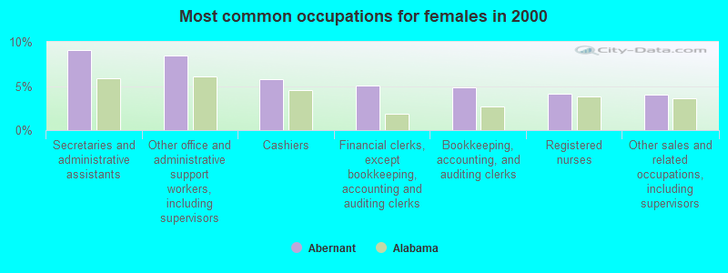
- Secretaries and administrative assistants (9.1%)
- Other office and administrative support workers, including supervisors (8.5%)
- Cashiers (5.8%)
- Financial clerks, except bookkeeping, accounting and auditing clerks (5.0%)
- Bookkeeping, accounting, and auditing clerks (4.8%)
- Registered nurses (4.1%)
- Other sales and related occupations, including supervisors (4.1%)
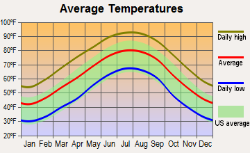
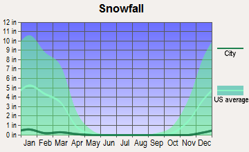
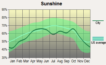
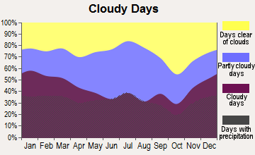
Average climate in Abernant, Alabama
Based on data reported by over 4,000 weather stations
(lower is better)
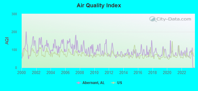
Air Quality Index (AQI) level in 2022 was 75.0. This is about average.
| City: | 75.0 |
| U.S.: | 72.6 |
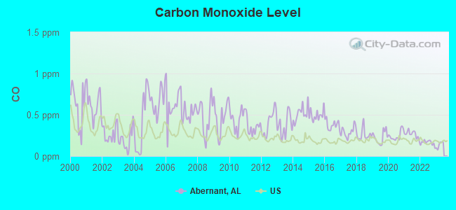
Carbon Monoxide (CO) [ppm] level in 2022 was 0.162. This is significantly better than average. Closest monitor was 19.9 miles away from the city center.
| City: | 0.162 |
| U.S.: | 0.251 |
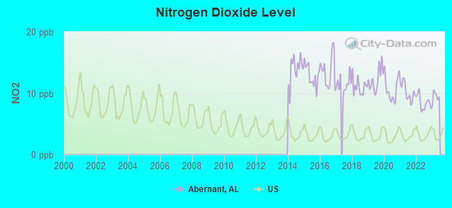
Nitrogen Dioxide (NO2) [ppb] level in 2022 was 8.49. This is significantly worse than average. Closest monitor was 14.3 miles away from the city center.
| City: | 8.49 |
| U.S.: | 5.11 |
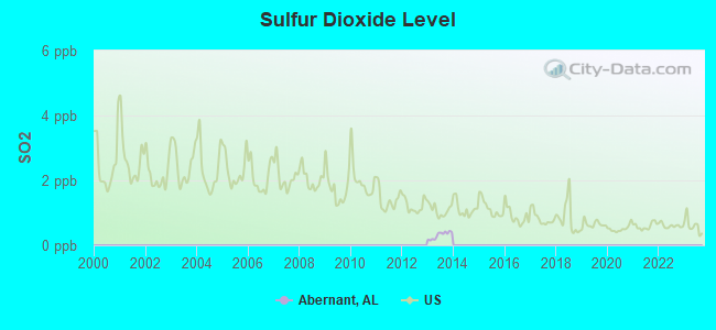
Sulfur Dioxide (SO2) [ppb] level in 2013 was 0.310. This is significantly better than average. Closest monitor was 14.3 miles away from the city center.
| City: | 0.310 |
| U.S.: | 1.515 |
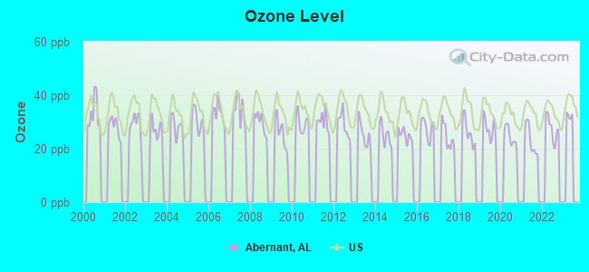
Ozone [ppb] level in 2022 was 27.5. This is better than average. Closest monitor was 16.0 miles away from the city center.
| City: | 27.5 |
| U.S.: | 33.3 |
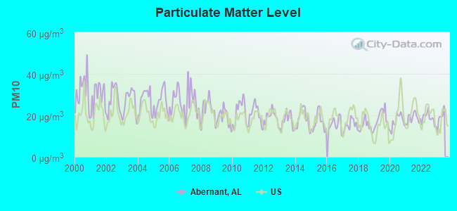
Particulate Matter (PM10) [µg/m3] level in 2022 was 18.5. This is about average. Closest monitor was 9.2 miles away from the city center.
| City: | 18.5 |
| U.S.: | 19.2 |
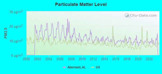
Particulate Matter (PM2.5) [µg/m3] level in 2022 was 8.76. This is about average. Closest monitor was 9.2 miles away from the city center.
| City: | 8.76 |
| U.S.: | 8.11 |
Tornado activity:
Abernant-area historical tornado activity is slightly above Alabama state average. It is 123% greater than the overall U.S. average.
On 4/8/1998, a category F5 (max. wind speeds 261-318 mph) tornado 15.7 miles away from the Abernant place center killed 32 people and injured 259 people and caused $200 million in damages.
On 3/3/1966, a category F5 tornado 17.3 miles away from the place center killed 58 people and injured 518 people and caused between $5,000,000 and $50,000,000 in damages.
Earthquake activity:
Abernant-area historical earthquake activity is significantly above Alabama state average. It is 132% greater than the overall U.S. average.On 1/18/1999 at 07:00:53, a magnitude 4.8 (4.8 MB, 4.0 LG, Depth: 0.6 mi, Class: Light, Intensity: IV - V) earthquake occurred 11.2 miles away from the city center
On 4/29/2003 at 08:59:39, a magnitude 4.9 (4.4 MB, 4.6 MW, 4.9 LG) earthquake occurred 121.4 miles away from Abernant center
On 6/24/1975 at 11:11:36, a magnitude 4.5 (4.5 MB) earthquake occurred 50.6 miles away from the city center
On 10/24/1997 at 08:35:17, a magnitude 4.9 (4.8 MB, 4.2 MS, 4.9 LG, Depth: 6.2 mi) earthquake occurred 148.8 miles away from the city center
On 4/29/2003 at 08:59:39, a magnitude 4.6 (4.6 MW, Depth: 12.3 mi) earthquake occurred 121.3 miles away from Abernant center
On 11/7/2004 at 11:20:21, a magnitude 4.3 (4.3 MW, Depth: 3.1 mi) earthquake occurred 62.8 miles away from the city center
Magnitude types: regional Lg-wave magnitude (LG), body-wave magnitude (MB), surface-wave magnitude (MS), moment magnitude (MW)
Natural disasters:
The number of natural disasters in Tuscaloosa County (23) is greater than the US average (15).Major Disasters (Presidential) Declared: 16
Emergencies Declared: 5
Causes of natural disasters: Storms: 12, Floods: 10, Tornadoes: 10, Hurricanes: 5, Winds: 4, Drought: 1, Snowfall: 1, Winter Storm: 1, Other: 1 (Note: some incidents may be assigned to more than one category).
Hospitals and medical centers near Abernant:
- PLANTATION MANOR NURSING HOME (Nursing Home, about 8 miles away; MC CALLA, AL)
- SOUTHERNCARE BESSEMER (Hospital, about 11 miles away; BESS, AL)
- GOLDEN LIVING CENTER - MEADOWOOD (Nursing Home, about 12 miles away; BESSEMER, AL)
- MEDICAL WEST, AN AFFILIATE OF UAB HEALTH SYSTEM Acute Care Hospitals (about 12 miles away; BESSEMER, AL)
- UAB MEDICAL WEST HOSPICE (Hospital, about 12 miles away; BESSEMER, AL)
- UAB MEDICAL WEST SKILLED NURSI (Nursing Home, about 12 miles away; BESSEMER, AL)
- BESSEMER KIDNEY CENTER (Dialysis Facility, about 12 miles away; BESSEMER, AL)
Colleges/universities with over 2000 students nearest to Abernant:
- Lawson State Community College-Birmingham Campus (about 20 miles; Birmingham, AL; Full-time enrollment: 2,695)
- University of Montevallo (about 20 miles; Montevallo, AL; FT enrollment: 2,826)
- Virginia College-Birmingham (about 24 miles; Birmingham, AL; FT enrollment: 8,167)
- The University of Alabama (about 24 miles; Tuscaloosa, AL; FT enrollment: 30,931)
- Samford University (about 25 miles; Birmingham, AL; FT enrollment: 3,829)
- University of Alabama at Birmingham (about 26 miles; Birmingham, AL; FT enrollment: 14,853)
- Shelton State Community College (about 27 miles; Tuscaloosa, AL; FT enrollment: 4,106)
Points of interest:
Notable locations in Abernant: Rockcastle (A), Lakeview Fire Department Station 1 (B), Lakeview Fire Department Station 2 (C), Lakeview Fire Department Headquarters (D), Abernant Volunteer Fire Department (E). Display/hide their locations on the map
Churches in Abernant include: Pleasant Grove Church (A), Antioch Baptist Church (B), First Baptist Church of Bucksville (C), Church of God (D), Union Cumberland Church (E), Reno Church (F), Hephzibah Church (G), Davis Creek Baptist Church (H), Hickman Church (I). Display/hide their locations on the map
Cemeteries: Pleasant Grove Cemetery (1), Hickman Chapel Cemetery (2), Hephzibah Cemetery (3), Davis Creek Cemetery (4), Bucksville Cemetery (5). Display/hide their locations on the map
Lakes and reservoirs: Reno Lake (A), Giles Lake (B), Woodland Lake (C), Dream Lakes (D), Gallant Lake (E), Blue Hole (F), Lake Paradise (G), Herring Lake (H). Display/hide their locations on the map
Streams, rivers, and creeks: Texas Creek (A), Rockcastle Creek (B), Mill Creek (C), Lye Branch (D), Gallant Branch (E), Buffalo Creek (F), Kennedy Creek (G). Display/hide their locations on the map
| This place: | 2.8 people |
| Alabama: | 2.5 people |
| This place: | 79.9% |
| Whole state: | 67.8% |
| This place: | 4.6% |
| Whole state: | 4.7% |
Likely homosexual households (counted as self-reported same-sex unmarried-partner households)
- Lesbian couples: 0.6% of all households
- Gay men: 0.2% of all households
| This place: | 8.1% |
| Whole state: | 16.1% |
| This place: | 3.1% |
| Whole state: | 7.3% |
For population 15 years and over in Abernant:
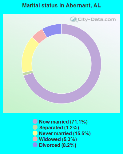
- Never married: 15.5%
- Now married: 71.1%
- Separated: 1.2%
- Widowed: 5.3%
- Divorced: 8.2%
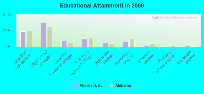
For population 25 years and over in Abernant:
- High school or higher: 76.0%
- Bachelor's degree or higher: 9.7%
- Graduate or professional degree: 2.3%
- Unemployed: 3.1%
- Mean travel time to work (commute): 33.0 minutes
| Here: | 11.2 |
| Alabama average: | 13.2 |
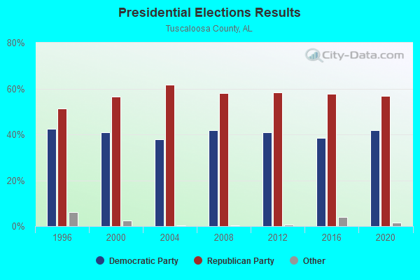
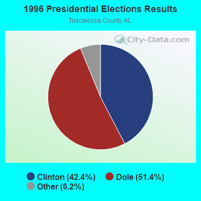
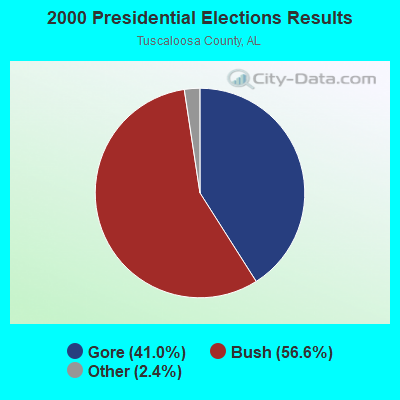
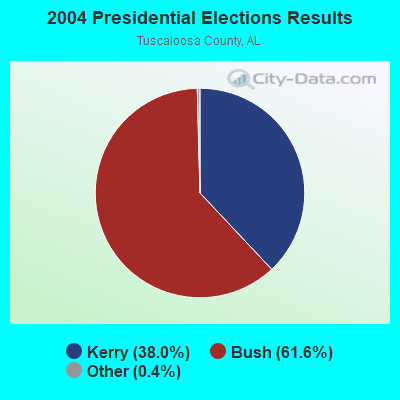
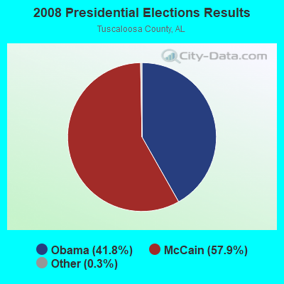
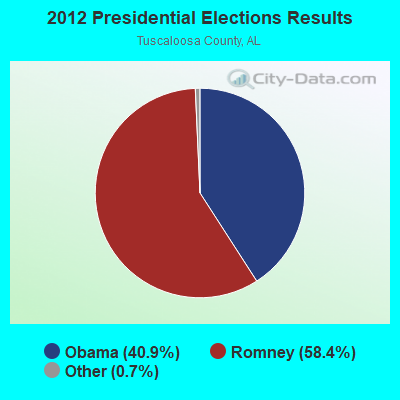
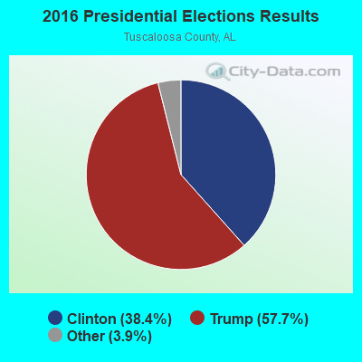
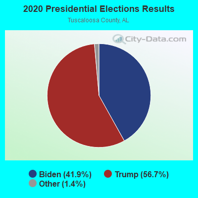
Graphs represent county-level data. Detailed 2008 Election Results
Religion statistics for Abernant, AL (based on Tuscaloosa County data)
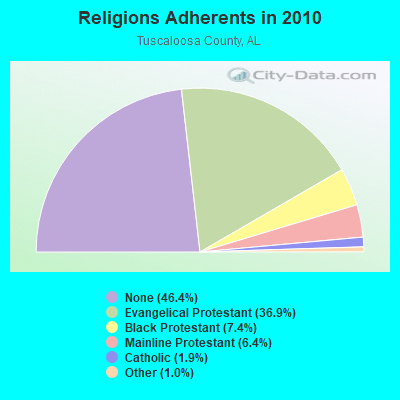
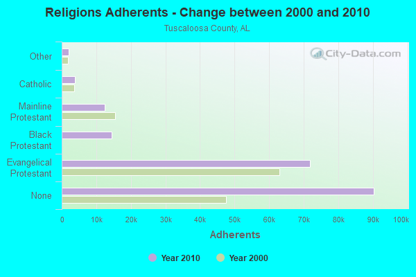
| Religion | Adherents | Congregations |
|---|---|---|
| Evangelical Protestant | 71,803 | 208 |
| Black Protestant | 14,428 | 45 |
| Mainline Protestant | 12,415 | 47 |
| Catholic | 3,729 | 2 |
| Other | 1,940 | 9 |
| None | 90,341 | - |
Food Environment Statistics:
| Tuscaloosa County: | 2.03 / 10,000 pop. |
| Alabama: | 1.89 / 10,000 pop. |
| This county: | 0.23 / 10,000 pop. |
| State: | 0.20 / 10,000 pop. |
| Tuscaloosa County: | 0.56 / 10,000 pop. |
| Alabama: | 0.65 / 10,000 pop. |
| Tuscaloosa County: | 5.70 / 10,000 pop. |
| State: | 6.32 / 10,000 pop. |
| Here: | 5.47 / 10,000 pop. |
| State: | 5.75 / 10,000 pop. |
| This county: | 10.7% |
| Alabama: | 11.8% |
| Tuscaloosa County: | 32.2% |
| Alabama: | 31.7% |
| This county: | 10.8% |
| State: | 13.5% |
Strongest AM radio stations in Abernant:
- WJOX (690 AM; 50 kW; BIRMINGHAM, AL; Owner: CITADEL BROADCASTING COMPANY)
- WAPI (1070 AM; 50 kW; BIRMINGHAM, AL; Owner: CITADEL BROADCASTING COMPANY)
- WDJC (850 AM; 50 kW; BIRMINGHAM, AL; Owner: KIMTRON, INC.)
- WTSK (790 AM; 5 kW; TUSCALOOSA, AL; Owner: APEX BROADCASTING INC.)
- WERC (960 AM; 5 kW; BIRMINGHAM, AL; Owner: CAPSTAR TX LIMITED PARTNERSHIP)
- WNSI (810 AM; 50 kW; JACKSONVILLE, AL; Owner: UNITED BROADCASTING NETWORK, INC.)
- WWPG (1280 AM; 5 kW; TUSCALOOSA, AL; Owner: LAWSON OF TUSCALOOSA, INC.)
- WSPZ (1150 AM; 5 kW; TUSCALOOSA, AL; Owner: RADIO SOUTH, INC)
- WACT (1420 AM; 5 kW; TUSCALOOSA, AL; Owner: CAPSTAR TX LIMITED PARTNERSHIP)
- WRJS (1320 AM; 5 kW; BIRMINGHAM, AL; Owner: CXR HOLDINGS, INC.)
- WYDE (1260 AM; 5 kW; BIRMINGHAM, AL; Owner: KIMTRON, INC.)
- WCPC (940 AM; 50 kW; HOUSTON, MS; Owner: WCPC BROADCASTING CO., INC.)
- WCOC (1010 AM; 5 kW; DORA, AL; Owner: AZTECA COMMUNICATIONS OF ALABAMA, INC.)
Strongest FM radio stations in Abernant:
- WDXB (102.5 FM; JASPER, AL; Owner: CAPSTAR TX LIMITED PARTNERSHIP)
- WANZ (100.7 FM; NORTHPORT, AL; Owner: APEX BRAODCASTING INC.)
- WODL (97.3 FM; HOMEWOOD, AL; Owner: CXR HOLDINGS, INC.)
- WMJJ (96.5 FM; BIRMINGHAM, AL; Owner: CAPSTAR TX LIMITED PARTNERSHIP)
- WQEN (103.7 FM; GADSDEN, AL; Owner: CAPSTAR TX LIMITED PARTNERSHIP)
- WYSF (94.5 FM; BIRMINGHAM, AL; Owner: CITADEL BROADCASTING COMPANY)
- WZRR (99.5 FM; BIRMINGHAM, AL; Owner: CITADEL BROADCASTING COMPANY)
- WDJC-FM (93.7 FM; BIRMINGHAM, AL; Owner: KIMTRON, INC.)
- WBHK (98.7 FM; WARRIOR, AL; Owner: CXR HOLDINGS, INC.)
- WZZK-FM (104.7 FM; BIRMINGHAM, AL; Owner: CXR HOLDINGS, INC.)
- WBPT (106.9 FM; BIRMINGHAM, AL; Owner: CXR HOLDINGS, INC.)
- WBHM (90.3 FM; BIRMINGHAM, AL; Owner: BD OF TRUSTEES/U OF AL AT BIRMINGHAM)
- WBHJ (95.7 FM; TUSCALOOSA, AL; Owner: CXR HOLDINGS, INC.)
- WTUG-FM (92.9 FM; TUSCALOOSA, AL; Owner: APEX BROADCASTING INC.)
- WUAL-FM (91.5 FM; TUSCALOOSA, AL; Owner: UNIVERSITY OF ALABAMA)
- WBFR (89.5 FM; BIRMINGHAM, AL; Owner: FAMILY STATIONS, INC.)
- WGIB (91.9 FM; BIRMINGHAM, AL; Owner: GLEN IRIS BAPTIST SCHOOL)
- W281AB (104.1 FM; MOUNTAIN BROOK, AL; Owner: FAMILY STATIONS, INC.)
- WRAX (107.7 FM; BIRMINGHAM, AL; Owner: CITADEL BROADCASTING COMPANY)
- WQEM (101.5 FM; COLUMBIANA, AL; Owner: GLEN IRIS BAPTIST SCHOOL)
TV broadcast stations around Abernant:
- WDBB (Channel 17; BESSEMER, AL; Owner: WDBB-TV, INC.)
- WCFT-TV (Channel 33; TUSCALOOSA, AL; Owner: TV ALABAMA, INCORPORATED)
- WABM (Channel 68; BIRMINGHAM, AL; Owner: BIRMINGHAM (WABM-TV) LICENSEE, INC.)
- WBXA-CA (Channel 2; BIRMINGHAM, AL; Owner: THE BOX WORLDWIDE LLC)
- WIAT (Channel 42; BIRMINGHAM, AL; Owner: MEDIA GENERAL COMMUNICATIONS, INC.)
- WBIQ (Channel 10; BIRMINGHAM, AL; Owner: ALABAMA EDUCATIONAL TELEVISION COMMISSION)
- WTTO (Channel 21; HOMEWOOD, AL; Owner: WTTO LICENSEE, LLC)
- WBRC (Channel 6; BIRMINGHAM, AL; Owner: WBRC LICENSE, INC.)
- WVTM-TV (Channel 13; BIRMINGHAM, AL; Owner: BIRMINGHAM BROADCASTING (WVTM-TV), LLC)
- WBMA-LP (Channel 58; BIRMINGHAM, AL; Owner: TV ALABAMA, INC.)
- WVUA-CA (Channel 7; TUSCALOOSA/NORTHPORT, AL; Owner: THE BOARD OF TRUSTEES OF THE UNIVERSITY OF ALABAMA)
- W15AZ (Channel 15; ALABASTER, AL; Owner: GLEN IRIS BAPTIST CHURCH SCHOOL)
- WLDM (Channel 23; TUSCALOOSA, AL; Owner: CHANNEL 23, LLC)
- W27CM (Channel 27; BIRMINGHAM, AL; Owner: EQUITY BROADCASTING CORPORATION)
- W46BU (Channel 46; TUSCALOOSA, AL; Owner: TRINITY BROADCASTING NETWORK)
- W46DK (Channel 46; BIRMINGHAM, AL; Owner: TRINITY BROADCASTING NETWORK)
- W34BI (Channel 34; BIRMINGHAM, AL; Owner: VENTANA TELEVISION, INC.)
FCC Registered Antenna Towers:
13 (See the full list of FCC Registered Antenna Towers in Abernant)FCC Registered Broadcast Land Mobile Towers:
1- Mildale Crossing (Lat: 33.279833 Lon: -87.249944), Type: Building, Structure height: 2.4 m, Overall height: 4.3 m, Call Sign: WQXC823,
Assigned Frequencies: 160.785 MHz, Grant Date: 02/02/2016, Expiration Date: 02/02/2026, Certifier: Shantrice Cruse-Scott, Registrant: Csx Transportation Inc, 6735 Southpoint Dr So, 4th Flr J958, Jacksonville, FL 32216-6177, Phone: (904) 332-5925, Fax: (904) 332-6013, Email:
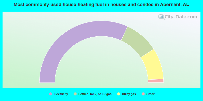
- 63.8%Electricity
- 18.0%Bottled, tank, or LP gas
- 16.3%Utility gas
- 1.5%Fuel oil, kerosene, etc.
- 0.4%Wood
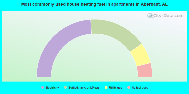
- 47.8%Electricity
- 32.6%Bottled, tank, or LP gas
- 11.7%Utility gas
- 7.8%No fuel used
Abernant compared to Alabama state average:
- Unemployed percentage significantly below state average.
- Black race population percentage significantly below state average.
- Hispanic race population percentage significantly below state average.
- Median age significantly below state average.
- Foreign-born population percentage significantly below state average.
- Renting percentage significantly below state average.
- Length of stay since moving in significantly above state average.
- Number of rooms per house significantly below state average.
- House age significantly below state average.
- Number of college students below state average.
- Percentage of population with a bachelor's degree or higher below state average.
Abernant on our top lists:
- #6 on the list of "Top 101 cities with largest percentage of females in occupations: legal support workers (population 5,000+)"
- #6 on the list of "Top 101 cities with largest percentage of females in industries: metals and minerals, except petroleum, merchant wholesalers (population 5,000+)"
- #7 on the list of "Top 101 cities with largest percentage of females in industries: motor vehicle and parts dealers (population 5,000+)"
- #8 on the list of "Top 101 cities with largest percentage of males in industries: gasoline stations (population 5,000+)"
- #10 on the list of "Top 101 cities with largest percentage of females in occupations: entertainers and performers, sports, and related workers (population 5,000+)"
- #10 on the list of "Top 101 cities with largest percentage of males in occupations: supervisors of construction and extraction workers (population 5,000+)"
- #11 on the list of "Top 101 cities with largest percentage of females in industries: religious, grantmaking, civic, professional, and similar organizations (population 5,000+)"
- #14 on the list of "Top 101 cities with largest percentage of females in occupations: financial clerks except bookkeeping, accounting, and auditing clerks (population 5,000+)"
- #18 on the list of "Top 101 cities with largest percentage of males in occupations: extraction workers (population 5,000+)"
- #23 on the list of "Top 101 cities with largest percentage of males in occupations: personal appearance workers (population 5,000+)"
- #24 on the list of "Top 101 cities with largest percentage of males in industries: metal and metal products (population 5,000+)"
- #38 on the list of "Top 101 larger cities with the lowest real estate taxes percentage (population 50,000+)"
- #40 on the list of "Top 101 cities with largest percentage of males in industries: book stores and news dealers (population 5,000+)"
- #49 on the list of "Top 101 cities with largest percentage of males in industries: office supplies and stationery stores (population 5,000+)"
- #56 on the list of "Top 101 cities with largest percentage of males in industries: miscellaneous durable goods merchant wholesalers (population 5,000+)"
- #60 on the list of "Top 101 cities with largest percentage of females in industries: motor vehicles, parts and supplies merchant wholesalers (population 5,000+)"
- #62 on the list of "Top 101 cities with largest percentage of females in industries: private households (population 5,000+)"
- #66 on the list of "Top 101 cities with largest percentage of females in industries: gasoline stations (population 5,000+)"
- #69 on the list of "Top 101 cities with largest percentage of males in industries: miscellaneous manufacturing (population 5,000+)"
- #73 on the list of "Top 101 cities with largest percentage of females in industries: management of companies and enterprises (population 5,000+)"
- #15 on the list of "Top 101 counties with the lowest Ozone (1-hour) air pollution readings in 2012 (ppm)"
- #16 on the list of "Top 101 counties with the worst general health status score of residents (1-5), 3 years of data"
- #18 on the list of "Top 101 counties with the lowest percentage of residents that visited a dentist within the past year"
- #23 on the list of "Top 101 counties with the lowest percentage of residents relocating from foreign countries between 2010 and 2011"
- #29 on the list of "Top 101 counties with the lowest percentage of residents that smoked 100+ cigarettes in their lives"