Adolphus, Kentucky
Submit your own pictures of this place and show them to the world
- OSM Map
- General Map
- Google Map
- MSN Map

| Males: 1,521 | |
| Females: 1,517 |
| Median resident age: | 33.6 years |
| Kentucky median age: | 35.9 years |
Zip code: 42120
| Adolphus: | $56,381 |
| KY: | $59,341 |
Estimated per capita income in 2022: $24,929 (it was $12,600 in 2000)
Adolphus CCD income, earnings, and wages data
Estimated median house or condo value in 2022: $140,279 (it was $51,400 in 2000)
| Adolphus: | $140,279 |
| KY: | $196,300 |
Detailed information about poverty and poor residents in Adolphus, KY


- 2,79397.3%White alone
- 381.3%Hispanic
- 200.7%Two or more races
- 100.3%American Indian alone
- 50.2%Black alone
- 20.07%Asian alone
- 20.07%Other race alone

Races in Adolphus detailed stats: ancestries, foreign born residents, place of birth
According to our research of Kentucky and other state lists, there were 10 registered sex offenders living in Adolphus, Kentucky as of June 17, 2024.
The ratio of all residents to sex offenders in Adolphus is 304 to 1.
 Recent articles from our blog. Our writers, many of them Ph.D. graduates or candidates, create easy-to-read articles on a wide variety of topics.
Current Local Time: CST time zone
Elevation: 640 feet
Land area: 60.3 square miles.
Population density: 50 people per square mile (very low).

| Adolphus CCD: | 0.5% ($252) |
| Kentucky: | 0.8% ($610) |
Nearest city with pop. 50,000+: Nashville-Davidson, TN  (44.8 miles , pop. 545,524).
Nearest city with pop. 1,000,000+: Chicago, IL (365.0 miles , pop. 2,896,016).
Nearest cities:
), ), ), ), )Latitude: 36.68 N, Longitude: 86.28 W


| Here: | 3.8% |
| Kentucky: | 3.8% |

- Transportation equipment (13.6%)
- Construction (10.4%)
- Health care (7.0%)
- Department & other general merchandise stores (5.9%)
- Electrical equipment, appliances, components (5.5%)
- Agriculture, forestry, fishing & hunting (4.4%)
- Educational services (4.3%)

- Construction (16.4%)
- Transportation equipment (12.7%)
- Wood products (6.2%)
- Agriculture, forestry, fishing & hunting (5.9%)
- Electrical equipment, appliances, components (5.6%)
- Department & other general merchandise stores (4.7%)
- Metal & metal products (4.5%)

- Health care (16.1%)
- Transportation equipment (14.8%)
- Department & other general merchandise stores (7.7%)
- Educational services (7.7%)
- Social assistance (5.4%)
- Electrical equipment, appliances, components (5.2%)
- Apparel (4.6%)

- Other production occupations, including supervisors (12.6%)
- Metal workers and plastic workers (7.3%)
- Assemblers and fabricators (5.8%)
- Driver/sales workers and truck drivers (4.1%)
- Material recording, scheduling, dispatching, and distributing workers (3.7%)
- Other office and administrative support workers, including supervisors (3.5%)
- Construction traders workers except carpenters, electricians, painters, plumbers, and construction laborers (3.0%)

- Other production occupations, including supervisors (11.3%)
- Metal workers and plastic workers (10.6%)
- Driver/sales workers and truck drivers (6.9%)
- Assemblers and fabricators (5.4%)
- Construction traders workers except carpenters, electricians, painters, plumbers, and construction laborers (5.1%)
- Other material moving workers, except laborers (4.0%)
- Material recording, scheduling, dispatching, and distributing workers (4.0%)

- Other production occupations, including supervisors (14.6%)
- Assemblers and fabricators (6.5%)
- Registered nurses (5.6%)
- Other office and administrative support workers, including supervisors (5.4%)
- Cashiers (5.0%)
- Preschool, kindergarten, elementary, and middle school teachers (4.4%)
- Nursing, psychiatric, and home health aides (4.0%)
Average climate in Adolphus, Kentucky
Based on data reported by over 4,000 weather stations


(lower is better)

Air Quality Index (AQI) level in 2022 was 53.2. This is better than average.
| City: | 53.2 |
| U.S.: | 72.6 |

Nitrogen Dioxide (NO2) [ppb] level in 2006 was 7.91. This is significantly worse than average. Closest monitor was 15.9 miles away from the city center.
| City: | 7.91 |
| U.S.: | 5.11 |

Sulfur Dioxide (SO2) [ppb] level in 2007 was 1.77. This is about average. Closest monitor was 16.6 miles away from the city center.
| City: | 1.77 |
| U.S.: | 1.51 |

Ozone [ppb] level in 2022 was 31.6. This is about average. Closest monitor was 15.9 miles away from the city center.
| City: | 31.6 |
| U.S.: | 33.3 |

Particulate Matter (PM2.5) [µg/m3] level in 2011 was 8.95. This is about average. Closest monitor was 23.2 miles away from the city center.
| City: | 8.95 |
| U.S.: | 8.11 |
Tornado activity:
Adolphus-area historical tornado activity is slightly above Kentucky state average. It is 60% greater than the overall U.S. average.
On 4/27/1970, a category F4 (max. wind speeds 207-260 mph) tornado 10.0 miles away from the Adolphus place center killed 3 people and injured 85 people and caused between $500,000 and $5,000,000 in damages.
On 2/6/2008, a category F3 (max. wind speeds 158-206 mph) tornado 9.9 miles away from the place center killed 4 people and injured 11 people and caused $1 million in damages.
Earthquake activity:
Adolphus-area historical earthquake activity is significantly above Kentucky state average. It is 168% greater than the overall U.S. average.On 4/18/2008 at 09:36:59, a magnitude 5.4 (5.1 MB, 4.8 MS, 5.4 MW, 5.2 MW, Class: Moderate, Intensity: VI - VII) earthquake occurred 151.0 miles away from the city center
On 4/18/2008 at 09:36:59, a magnitude 5.2 (5.2 MW, Depth: 8.9 mi) earthquake occurred 151.0 miles away from Adolphus center
On 6/18/2002 at 17:37:15, a magnitude 5.0 (4.3 MB, 4.6 MW, 5.0 LG) earthquake occurred 122.5 miles away from the city center
On 7/27/1980 at 18:52:21, a magnitude 5.2 (5.1 MB, 4.7 MS, 5.0 UK, 5.2 UK) earthquake occurred 166.4 miles away from the city center
On 6/10/1987 at 23:48:54, a magnitude 5.1 (4.9 MB, 4.4 MS, 4.6 MS, 5.1 LG) earthquake occurred 172.3 miles away from Adolphus center
On 4/29/2003 at 08:59:39, a magnitude 4.9 (4.4 MB, 4.6 MW, 4.9 LG, Class: Light, Intensity: IV - V) earthquake occurred 155.3 miles away from the city center
Magnitude types: regional Lg-wave magnitude (LG), body-wave magnitude (MB), surface-wave magnitude (MS), moment magnitude (MW)
Natural disasters:
The number of natural disasters in Allen County (12) is smaller than the US average (15).Major Disasters (Presidential) Declared: 8
Emergencies Declared: 3
Causes of natural disasters: Floods: 6, Storms: 6, Winter Storms: 3, Tornadoes: 2, Blizzard: 1, Freeze: 1, Hurricane: 1, Mudslide: 1, Snow: 1, Snowfall: 1, Wind: 1, Other: 1 (Note: some incidents may be assigned to more than one category).
Hospitals and medical centers near Adolphus:
- MEDICAL CENTER AT SCOTTSVILLE,THE (Hospital, about 7 miles away; SCOTTSVILLE, KY)
- CAL TURNER REHAB AND SPECIALTY CARE (Nursing Home, about 7 miles away; SCOTTSVILLE, KY)
- RCG PORTLAND (Dialysis Facility, about 16 miles away; PORTLAND, TN)
- FRANKLIN-SIMPSON NURSING AND REHABILITATION CENTER (Nursing Home, about 16 miles away; FRANKLIN, KY)
Colleges/universities with over 2000 students nearest to Adolphus:
- Western Kentucky University (about 24 miles; Bowling Green, KY; Full-time enrollment: 16,942)
- Southcentral Kentucky Community and Technical College (about 24 miles; Bowling Green, KY; FT enrollment: 2,794)
- Volunteer State Community College (about 25 miles; Gallatin, TN; FT enrollment: 5,311)
- Trevecca Nazarene University (about 46 miles; Nashville, TN; FT enrollment: 2,223)
- Tennessee State University (about 47 miles; Nashville, TN; FT enrollment: 7,341)
- Vanderbilt University (about 47 miles; Nashville, TN; FT enrollment: 10,518)
- Belmont University (about 48 miles; Nashville, TN; FT enrollment: 5,795)
Points of interest:
Notable locations in Adolphus: Stony Point Volunteer Fire Department (A), South Allen Fire Department Station 2 (B). Display/hide their locations on the map
Churches in Adolphus include: Macedonia Baptist Church (A), Maple Grove Church (B), Mount Gilead Church (C), New Buck Creek Methodist Church (D), Oak Forest Number 1 Missionary Baptist Church (E), Oak Grove Baptist Church (F), Old Buck Creek Church (G), Pleasant Ridge Church (H), Stoney Point United Methodist Church (I). Display/hide their locations on the map
Cemeteries: Oak Forest Cemetery Number 1 (1), Harrell Cemetery (2), Hinton Cemetery (3), Nancy Cemetery (4), Wolf Cemetery (5). Display/hide their locations on the map
Streams, rivers, and creeks: Wolf Branch (A), Casey Branch (B), Snyder Branch (C), Snake Creek (D), Smyrna Creek (E), Mays Branch (F), Hinton Branch (G), Rock Quarry Branch (H), Florida Creek (I). Display/hide their locations on the map
| This place: | 2.6 people |
| Kentucky: | 2.5 people |
| This place: | 72.3% |
| Whole state: | 66.9% |
| This place: | 6.4% |
| Whole state: | 6.4% |
Likely homosexual households (counted as self-reported same-sex unmarried-partner households)
- Lesbian couples: 0.5% of all households
- Gay men: 0.4% of all households
| This place: | 17.8% |
| Whole state: | 15.8% |
| This place: | 5.4% |
| Whole state: | 6.6% |
For population 15 years and over in Adolphus:

- Never married: 18.2%
- Now married: 64.2%
- Separated: 2.1%
- Widowed: 6.2%
- Divorced: 11.3%
For population 25 years and over in Adolphus:
- High school or higher: 55.0%
- Bachelor's degree or higher: 3.8%
- Graduate or professional degree: 1.2%
- Unemployed: 6.5%
- Mean travel time to work (commute): 31.3 minutes


| Here: | 17.4 |
| Kentucky average: | 13.8 |
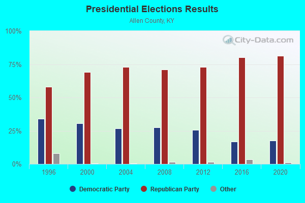
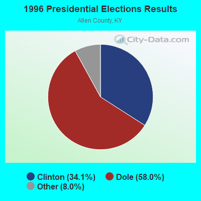
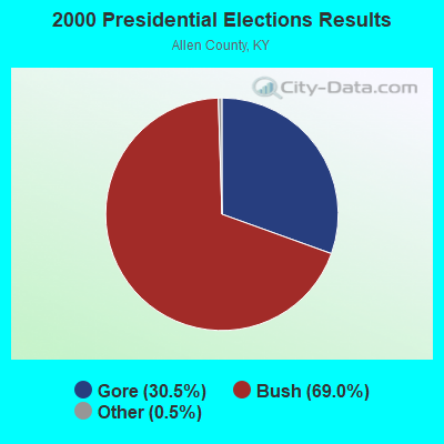


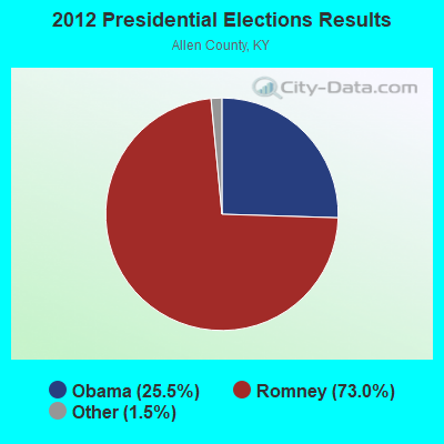
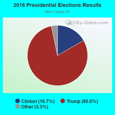
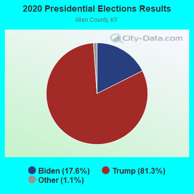
Graphs represent county-level data. Detailed 2008 Election Results
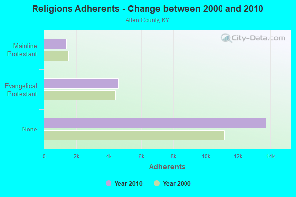
Religion statistics for Adolphus, KY (based on Allen County data)
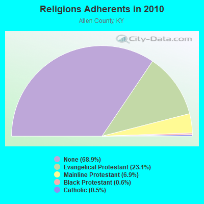
| Religion | Adherents | Congregations |
|---|---|---|
| Evangelical Protestant | 4,602 | 23 |
| Mainline Protestant | 1,383 | 12 |
| Black Protestant | 123 | 1 |
| Catholic | 102 | 1 |
| Other | 3 | - |
| None | 13,743 | - |
Food Environment Statistics:
| Allen County: | 2.65 / 10,000 pop. |
| Kentucky: | 2.19 / 10,000 pop. |
| Allen County: | 4.77 / 10,000 pop. |
| State: | 4.36 / 10,000 pop. |
| Here: | 2.65 / 10,000 pop. |
| State: | 5.74 / 10,000 pop. |
| This county: | 11.7% |
| Kentucky: | 11.0% |
| Allen County: | 31.0% |
| Kentucky: | 30.0% |
| This county: | 14.0% |
| State: | 15.9% |
Strongest AM radio stations in Adolphus:
- WSM (650 AM; 50 kW; NASHVILLE, TN; Owner: GAYLORD ENTERTAINMENT COMPANY)
- WAMB (1160 AM; 50 kW; DONELSON, TN; Owner: GREAT SOUTHERN BROADCASTING COMPANY, INC.)
- WLAC (1510 AM; 50 kW; NASHVILLE, TN; Owner: CAPSTAR TX LIMITED PARTNERSHIP)
- WKDA (1200 AM; 50 kW; NASHVILLE, TN; Owner: RADIO NASHVILLE, INC.)
- WNQM (1300 AM; 50 kW; NASHVILLE, TN; Owner: WNQM. INC.)
- WHIN (1010 AM; 5 kW; GALLATIN, TN; Owner: WHIN, INC.)
- WLCK (1250 AM; 1 kW; SCOTTSVILLE, KY; Owner: SHERANDAN BROADCASTING CO., INC.)
- WPLN (1430 AM; 15 kW; MADISON, TN)
- WKCT (930 AM; 5 kW; BOWLING GREEN, KY; Owner: DAILY NEWS BROADCASTING CO.)
- WYXE (1130 AM; daytime; 2 kW; GALLATIN, TN; Owner: JON GARY ENTERPRISES, INC.)
- WWAM (820 AM; daytime; 50 kW; JASPER, TN; Owner: SHELTON BROADCASTING SYSTEM)
- WHAS (840 AM; 50 kW; LOUISVILLE, KY; Owner: CLEAR CHANNEL BROADCASTING LICENSES, INC.)
- WQKR (1270 AM; 1 kW; PORTLAND, TN; Owner: BRAVO BROADCASTING CO., INC.)
Strongest FM radio stations in Adolphus:
- WGGC (95.1 FM; GLASGOW, KY; Owner: HERITAGE COMMUNICATIONS, INC.)
- WVLE (99.3 FM; SCOTTSVILLE, KY; Owner: SHERANDAN BROADCASTING COMPANY, INC.)
- WUBT (101.1 FM; RUSSELLVILLE, KY; Owner: CAPSTAR TX LIMITED PARTNERSHIP)
- WGFX (104.5 FM; GALLATIN, TN; Owner: CITADEL BROADCASTING COMPANY)
- WMAK (96.3 FM; MURFREESBORO, TN; Owner: SOUTH CENTRAL COMMUNICATIONS CORP.)
- WDNS (93.3 FM; BOWLING GREEN, KY; Owner: DAILY NEWS BROADCASTING COMPANY)
- WKYU-FM (88.9 FM; BOWLING GREEN, KY; Owner: WESTERN KENTUCKY UNIVERSITY)
- WRVW (107.5 FM; LEBANON, TN; Owner: CAPSTAR TX LIMITED PARTNERSHIP)
- W230AD (93.9 FM; GALLATIN, TN; Owner: TREVECCA NAZARENE UNIVERSITY, INC.)
- WMOT (89.5 FM; MURFREESBORO, TN; Owner: MIDDLE TENNESSEE STATE UNIVERSITY)
- WSM-FM (95.5 FM; NASHVILLE, TN; Owner: CUMULUS LICENSING CORP.)
- WLCT (102.1 FM; LAFAYETTE, TN; Owner: LAFAYETTE BROADCASTING CO., INC.)
- WVCP (88.5 FM; GALLATIN, TN; Owner: VOLUNTEER STATE COMMUNITY COLLEGE)
- WUHU (107.1 FM; SMITHS GROVE, KY; Owner: FOREVER COMMUNICATIONS INC)
- WBVR-FM (96.7 FM; AUBURN, KY; Owner: FOREVER COMMUNICATIONS INC)
- WCVK (90.7 FM; BOWLING GREEN, KY; Owner: BOWLING GREEN COMMTY. B/CSTG, INC.)
- WKLX (100.7 FM; BROWNSVILLE, KY; Owner: CHARLES M. ANDERSON)
- WWHR (91.7 FM; BOWLING GREEN, KY; Owner: WESTERN KENTUCKY UNIVERSITY)
- W203BI (88.5 FM; BOWLING GREEN, KY; Owner: WAY-FM MEDIA GROUP, INC.)
TV broadcast stations around Adolphus:
- WPGD (Channel 50; HENDERSONVILLE, TN; Owner: TRINITY BROADCASTING NETWORK)
- WPBM-LP (Channel 48; SCOTTSVILLE, KY; Owner: PROCLAIM BROADCASTING, INC.)
- WTVF (Channel 5; NASHVILLE, TN; Owner: NEWSCHANNEL 5 NETWORK, LP)
- WNPX (Channel 28; COOKEVILLE, TN; Owner: PAXSON COMMUNICATIONS LICENSE COMPANY, LLC)
- WUXP-TV (Channel 30; NASHVILLE, TN; Owner: WUXP LICENSEE, LLC)
- WSMV-TV (Channel 4; NASHVILLE, TN; Owner: MEREDITH CORPORATION)
- W62CJ (Channel 62; JACKSON, TN; Owner: MS COMMUNICATIONS, LLC)
- WZTV (Channel 17; NASHVILLE, TN; Owner: WZTV LICENSEE, LLC)
- WBKO (Channel 13; BOWLING GREEN, KY; Owner: GRAY MIDAMERICA TV LICENSEE CORP.)
- WNKY (Channel 40; BOWLING GREEN, KY; Owner: MMK LICENSE LLC)
- WKYU-TV (Channel 24; BOWLING GREEN, KY; Owner: WESTERN KENTUCKY UNIVERSITY)
FCC Registered Cell Phone Towers:
1- Allen South, 371 Andrew Jackson Highway (Lat: 36.672361 Lon: -86.253083), Type: Tower, Structure height: 57.9 m, Overall height: 60.7 m, Call Sign: KNKN867
Assigned Frequencies: 880.020 MHz, 880.020 MHz, 880.020 MHz, 835.020 MHz, 835.020 MHz, 835.020 MHz, 891.510 MHz, 891.510 MHz, 891.510 MHz, 846.510 MHz, 846.510 MHz, 846.510 MHzGrant Date: 09/01/2020, Expiration Date: 10/01/2030, Certifier: Gregory M RomanoRegistrant: Verizon, 1300 I Street, Nw - Suite 500 East, Washington, DC 20005, Phone: (202) 515-2453, Email:
FCC Registered Amateur Radio Licenses:
4- Call Sign: KF4GCQ, Licensee ID: L01093259, Grant Date: 12/20/2005, Expiration Date: 01/18/2016, Cancellation Date: 01/19/2018, Registrant: Kenneth T Williams, 1405 O\'Neal Rd., Adolphus, KY 42120
- Call Sign: KI4TFY, Licensee ID: L01241562, Grant Date: 05/30/2017, Expiration Date: 02/01/2027, Certifier: Ronald M Hawks, Registrant: Ronald M Hawks, 19 Mcdonald Rd, Adolphus, KY 42120
- Call Sign: KJ4CME, Licensee ID: L01377045, Grant Date: 03/06/2008, Expiration Date: 03/06/2018, Cancellation Date: 03/07/2020, Certifier: Tabitha M Oliver, Registrant: Tabitha M Oliver, 19 Mcdonald Rd, Adolphus, KY 42120
- Call Sign: K4JAE, Previous Call Sign: KJ4BTM, Licensee ID: L00456499, Grant Date: 01/30/2018, Expiration Date: 03/21/2028, Certifier: John A Elmore Jr., Registrant: John A Elmore Jr, 300 Travelstead Rd, Adolphus, KY 42120
2002 - 2018 National Fire Incident Reporting System (NFIRS) incidents
- Fire incident types reported to NFIRS in Adolphus, KY
- 6545.1%Structure Fires
- 5941.0%Outside Fires
- 1611.1%Mobile Property/Vehicle Fires
- 42.8%Other
 According to the data from the years 2002 - 2018 the average number of fires per year is 8. The highest number of fire incidents - 23 took place in 2017, and the least - 0 in 2008. The data has a declining trend.
 When looking into fire subcategories, the most incidents belonged to: Structure Fires (45.1%), and Outside Fires (41.0%).
- 57.8%Electricity
- 32.0%Bottled, tank, or LP gas
- 6.8%Wood
- 2.1%Fuel oil, kerosene, etc.
- 1.3%Solar energy

- 47.0%Electricity
- 26.0%Bottled, tank, or LP gas
- 12.2%Wood
- 11.6%Fuel oil, kerosene, etc.
- 3.3%Utility gas
Adolphus compared to Kentucky state average:
- Unemployed percentage below state average.
- Black race population percentage significantly below state average.
- Hispanic race population percentage significantly below state average.
- Median age below state average.
- Foreign-born population percentage significantly below state average.
- Length of stay since moving in significantly above state average.
- Number of rooms per house significantly below state average.
- House age significantly below state average.
- Number of college students below state average.
- Percentage of population with a bachelor's degree or higher significantly below state average.