Atkinson, Maine
Submit your own pictures of this town and show them to the world
- OSM Map
- Google Map
- MSN Map
Population change since 2000: +0.9%
 |
| Males: 175 | |
| Females: 151 |
| Median resident age: | 47.8 years |
| Maine median age: | 43.0 years |
Zip codes: 04426.
| Atkinson: | $55,721 |
| ME: | $69,543 |
Estimated per capita income in 2022: $34,961 (it was $14,755 in 2000)
Atkinson town income, earnings, and wages data
Estimated median house or condo value in 2022: $173,984 (it was $66,900 in 2000)
| Atkinson: | $173,984 |
| ME: | $290,600 |
Mean prices in 2022: all housing units: $203,844; detached houses: $217,964; townhouses or other attached units: $250,113; in 2-unit structures: $253,343; in 3-to-4-unit structures: $283,591; in 5-or-more-unit structures: $146,783; mobile homes: $82,683
Detailed information about poverty and poor residents in Atkinson, ME


- 31596.6%White alone
- 41.2%American Indian alone
- 41.2%Two or more races
- 10.3%Asian alone
- 10.3%Native Hawaiian and Other
Pacific Islander alone - 10.3%Hispanic

Races in Atkinson detailed stats: ancestries, foreign born residents, place of birth
According to our research of Maine and other state lists, there was 1 registered sex offender living in Atkinson, Maine as of June 17, 2024.
The ratio of all residents to sex offenders in Atkinson is 326 to 1.
 Recent articles from our blog. Our writers, many of them Ph.D. graduates or candidates, create easy-to-read articles on a wide variety of topics.
Ancestries: English (37.2%), Irish (11.5%), French (10.2%), Scottish (10.2%), German (7.1%), United States (6.8%).
Current Local Time: EST time zone
Incorporated on 02/12/1819
Land area: 39.2 square miles.
Population density: 8.3 people per square mile (very low).
3 residents are foreign born
| This town: | 0.9% |
| Maine: | 2.9% |
| Atkinson town: | 1.3% ($855) |
| Maine: | 1.5% ($1,417) |
Nearest city with pop. 50,000+: Portland, ME  (119.2 miles , pop. 64,249).
Nearest city with pop. 200,000+: Boston, MA (220.7 miles , pop. 589,141).
Nearest city with pop. 1,000,000+: Bronx, NY (384.7 miles , pop. 1,332,650).
Nearest cities:
), ), )Latitude: 45.16 N, Longitude: 69.06 W
Area code commonly used in this area: 207

Single-family new house construction building permits:
- 2013: 1 building, cost: $150,000
- 2007: 1 building, cost: $90,000
- 2006: 1 building, cost: $100,000
- 2004: 2 buildings, average cost: $65,000
- 1999: 1 building, cost: $180,000
- 1998: 2 buildings, average cost: $55,000
- 1997: 1 building, cost: $40,000


| Here: | 2.6% |
| Maine: | 3.4% |


- Health care (15.6%)
- Construction (12.5%)
- Agriculture, forestry, fishing & hunting (5.6%)
- Educational services (5.0%)
- Repair & maintenance (4.4%)
- Professional, scientific, technical services (4.4%)
- Computer & electronic products (3.1%)

- Construction (21.1%)
- Professional, scientific, technical services (7.4%)
- Health care (7.4%)
- Repair & maintenance (7.4%)
- Agriculture, forestry, fishing & hunting (6.3%)
- Public administration (5.3%)
- Utilities (5.3%)

- Health care (27.7%)
- Educational services (12.3%)
- Department & other general merchandise stores (7.7%)
- Computer & electronic products (7.7%)
- Administrative & support & waste management services (6.2%)
- Agriculture, forestry, fishing & hunting (4.6%)
- Leather & allied products (4.6%)

- Other production occupations, including supervisors (9.4%)
- Material recording, scheduling, dispatching, and distributing workers (6.9%)
- Nursing, psychiatric, and home health aides (4.4%)
- Carpenters (4.4%)
- Driver/sales workers and truck drivers (3.8%)
- Other management occupations, except farmers and farm managers (3.8%)
- Retail sales workers, except cashiers (3.8%)

- Other production occupations, including supervisors (9.5%)
- Carpenters (7.4%)
- Fishing, hunting, and forestry occupations (6.3%)
- Vehicle and mobile equipment mechanics, installers, and repairers (6.3%)
- Driver/sales workers and truck drivers (6.3%)
- Material recording, scheduling, dispatching, and distributing workers (5.3%)
- Plant and system operators (5.3%)

- Nursing, psychiatric, and home health aides (10.8%)
- Material recording, scheduling, dispatching, and distributing workers (9.2%)
- Other production occupations, including supervisors (9.2%)
- Preschool, kindergarten, elementary, and middle school teachers (6.2%)
- Other management occupations, except farmers and farm managers (6.2%)
- Other teachers, instructors, education, training, and library occupations (6.2%)
- Retail sales workers, except cashiers (6.2%)
Average climate in Atkinson, Maine
Based on data reported by over 4,000 weather stations


(lower is better)

Air Quality Index (AQI) level in 2014 was 42.7. This is significantly better than average.
| City: | 42.7 |
| U.S.: | 72.6 |

Ozone [ppb] level in 2015 was 16.3. This is significantly better than average. Closest monitor was 7.5 miles away from the city center.
| City: | 16.3 |
| U.S.: | 33.3 |
Earthquake activity:
Atkinson-area historical earthquake activity is significantly above Maine state average. It is 81% smaller than the overall U.S. average.On 4/20/2002 at 10:50:47, a magnitude 5.3 (5.3 ML, Depth: 3.0 mi, Class: Moderate, Intensity: VI - VII) earthquake occurred 231.7 miles away from the city center
On 4/20/2002 at 10:50:47, a magnitude 5.2 (5.2 MB, 4.2 MS, 5.2 MW, 5.0 MW) earthquake occurred 233.1 miles away from Atkinson center
On 10/16/2012 at 23:12:25, a magnitude 4.7 (4.7 ML, Depth: 10.0 mi, Class: Light, Intensity: IV - V) earthquake occurred 133.6 miles away from the city center
On 10/7/1983 at 10:18:46, a magnitude 5.3 (5.1 MB, 5.3 LG, 5.1 ML) earthquake occurred 273.2 miles away from the city center
On 1/19/1982 at 00:14:42, a magnitude 4.7 (4.5 MB, 4.7 MD, 4.5 LG) earthquake occurred 170.1 miles away from Atkinson center
On 2/26/1999 at 03:38:43, a magnitude 3.8 (3.8 LG, Depth: 2.0 mi, Class: Light, Intensity: II - III) earthquake occurred 52.0 miles away from the city center
Magnitude types: regional Lg-wave magnitude (LG), body-wave magnitude (MB), duration magnitude (MD), local magnitude (ML), surface-wave magnitude (MS), moment magnitude (MW)
Natural disasters:
The number of natural disasters in Piscataquis County (22) is greater than the US average (15).Major Disasters (Presidential) Declared: 15
Emergencies Declared: 6
Causes of natural disasters: Floods: 13, Storms: 12, Snows: 7, Heavy Rains: 2, Blizzard: 1, Ice Storm: 1, Landslide: 1, Snowfall: 1, Wind: 1, Winter Storm: 1, Other: 2 (Note: some incidents may be assigned to more than one category).
Colleges/universities with over 2000 students nearest to Atkinson:
- University of Maine (about 27 miles; Orono, ME; Full-time enrollment: 8,931)
- Husson University (about 27 miles; Bangor, ME; FT enrollment: 2,421)
- University of Maine at Farmington (about 64 miles; Farmington, ME; FT enrollment: 2,036)
- University of Maine at Augusta (about 68 miles; Augusta, ME; FT enrollment: 3,204)
- Saint Joseph's College of Maine (about 116 miles; Standish, ME; FT enrollment: 2,010)
- Southern Maine Community College (about 120 miles; South Portland, ME; FT enrollment: 4,666)
- University of Southern Maine (about 120 miles; Portland, ME; FT enrollment: 6,647)
Points of interest:
Notable location: Atkinson Corners (A). Display/hide its location on the map
Church in Atkinson: Atkinson Church (A). Display/hide its location on the map
Cemeteries: North Atkinson Cemetery (1), Hart Cemetery (2), Farnham Cemetery (3), Greenwood Cemetery (4), Gould Cemetery (5). Display/hide their locations on the map
Streams, rivers, and creeks: Hall Brook (A), Brown Brook (B). Display/hide their locations on the map
Birthplace of: Frank Atwood Huntington - Inventor.
| This town: | 2.4 people |
| Maine: | 2.3 people |
| This town: | 67.4% |
| Whole state: | 62.9% |
| This town: | 10.4% |
| Whole state: | 9.4% |
No gay or lesbian households reported
| This town: | 17.9% |
| Whole state: | 10.9% |
| This town: | 4.5% |
| Whole state: | 4.1% |
For population 15 years and over in Atkinson:

- Never married: 16.0%
- Now married: 71.3%
- Separated: 1.1%
- Widowed: 2.9%
- Divorced: 8.7%
For population 25 years and over in Atkinson:
- High school or higher: 81.7%
- Bachelor's degree or higher: 14.7%
- Graduate or professional degree: 5.6%
- Unemployed: 3.0%
- Mean travel time to work (commute): 26.5 minutes


| Here: | 10.2 |
| Maine average: | 11.2 |
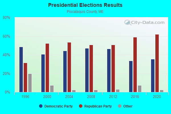
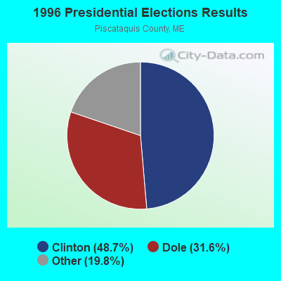
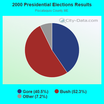
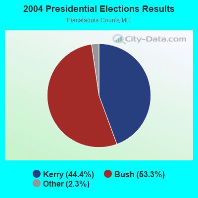
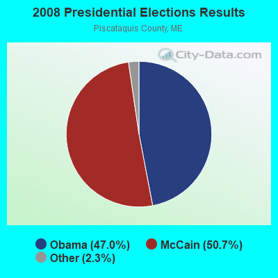
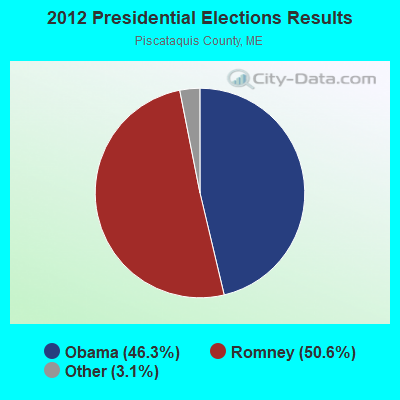
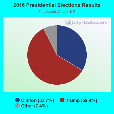
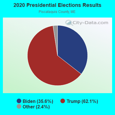
Graphs represent county-level data. Detailed 2008 Election Results
Religion statistics for Atkinson, ME (based on Piscataquis County data)
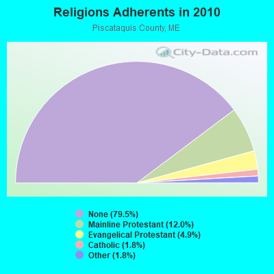
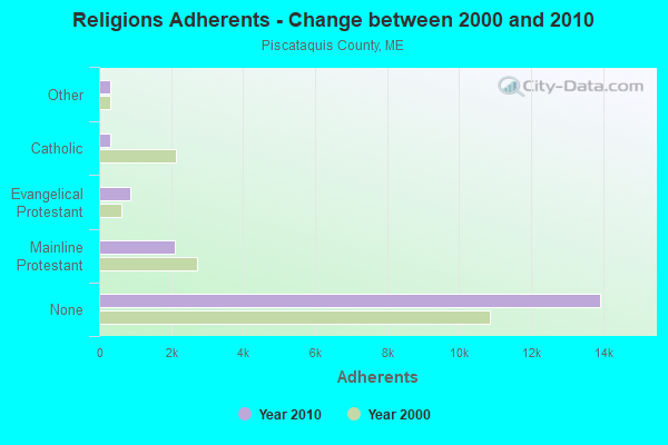
| Religion | Adherents | Congregations |
|---|---|---|
| Mainline Protestant | 2,108 | 13 |
| Evangelical Protestant | 855 | 13 |
| Catholic | 320 | 3 |
| Other | 318 | 5 |
| None | 13,934 | - |
Food Environment Statistics:
| Piscataquis County: | 5.24 / 10,000 pop. |
| Maine: | 2.80 / 10,000 pop. |
| Piscataquis County: | 4.08 / 10,000 pop. |
| Maine: | 2.20 / 10,000 pop. |
| Piscataquis County: | 8.74 / 10,000 pop. |
| State: | 5.75 / 10,000 pop. |
| Here: | 10.49 / 10,000 pop. |
| State: | 11.02 / 10,000 pop. |
| This county: | 8.4% |
| Maine: | 8.2% |
| Piscataquis County: | 27.5% |
| Maine: | 25.0% |
Strongest AM radio stations in Atkinson:
- WZON (620 AM; 5 kW; BANGOR, ME; Owner: THE ZONE CORPORATION)
- WABI (910 AM; 5 kW; BANGOR, ME; Owner: CLEAR CHANNEL BROADCASTING LICENSES, INC.)
- WSKW (1160 AM; 10 kW; SKOWHEGAN, ME; Owner: MOUNTAIN WIRELESS, INCORPORATED)
- WTME (780 AM; 10 kW; RUMFORD, ME; Owner: MOUNTAIN VALLEY BROADCASTING, INC.)
- WRKO (680 AM; 50 kW; BOSTON, MA; Owner: ENTERCOM BOSTON LICENSE, LLC)
- WDEA (1370 AM; 5 kW; ELLSWORTH, ME; Owner: CUMULUS LICENSING CORP.)
- WEEI (850 AM; 50 kW; BOSTON, MA; Owner: ENTERCOM BOSTON LICENSE, LLC)
- WBZ (1030 AM; 50 kW; BOSTON, MA; Owner: INFINITY BROADCASTING OPERATIONS, INC.)
- WCHP (760 AM; 35 kW; CHAMPLAIN, NY; Owner: CHAMPLAIN RADIO, INC.)
- WNNZ (640 AM; 50 kW; WESTFIELD, MA; Owner: CLEAR CHANNEL BROADCASTING LICENSES, INC.)
- WCRN (830 AM; 50 kW; WORCESTER, MA; Owner: CARTER BROADCASTING CORPORATION)
- WNZS (1340 AM; 1 kW; VEAZIE, ME; Owner: WATERFRONT COMMUNICATIONS INC.)
- WKOX (1200 AM; 50 kW; FRAMINGHAM, MA; Owner: CAPSTAR TX LIMITED PARTNERSHIP)
Strongest FM radio stations in Atkinson:
- WQCB (106.5 FM; BREWER, ME; Owner: CUMULUS LICENSING CORP.)
- WVOM (103.9 FM; HOWLAND, ME; Owner: CLEAR CHANNEL BROADCASTING LICENSES, INC.)
- WGUY (102.1 FM; DEXTER, ME; Owner: CONCORD MEDIA GROUP, INC.)
- WDME-FM (103.1 FM; DOVER-FOXCROFT, ME; Owner: THE ZONE CORPORATION)
- WHCF (88.5 FM; BANGOR, ME; Owner: BANGOR BAPTIST CHURCH)
- WWBX (97.1 FM; BANGOR, ME; Owner: CLEAR CHANNEL BROADCASTING LICENSES, INC.)
- WBZN (107.3 FM; OLD TOWN, ME; Owner: CUMULUS LICENSING CORP.)
- WTOS-FM (105.1 FM; SKOWHEGAN, ME; Owner: CAPSTAR TX LIMITED PARTNERSHIP)
- WBFB (104.7 FM; BELFAST, ME; Owner: CLEAR CHANNEL BROADCASTING LICENSES, INC.)
- WKIT-FM (100.3 FM; BREWER, ME; Owner: THE ZONE CORPORATION)
- WWMJ (95.7 FM; ELLSWORTH, ME; Owner: CUMULUS LICENSING CORP.)
- WMEH (90.9 FM; BANGOR, ME; Owner: MAINE PUBLIC BROADCASTING CORPORATION)
- WEZQ (92.9 FM; BANGOR, ME; Owner: CUMULUS LICENSING CORP.)
- WHMX (105.7 FM; LINCOLN, ME; Owner: BANGOR BAPTIST CHURCH)
- WJCX (99.5 FM; PITTSFIELD, ME; Owner: CSN INTERNATIONAL)
TV broadcast stations around Atkinson:
- WABI-TV (Channel 5; BANGOR, ME; Owner: COMMUNITY BROADCASTING SERVICE)
- W27CE (Channel 19; DOVER-FOXCROFT, ME; Owner: TRINITY BROADCASTING NETWORK)
- National Bridge Inventory (NBI) Statistics
- 4Number of bridges
- 308ft / 93.7mTotal length
- 15,167Total average daily traffic
- 1,178Total average daily truck traffic
- 17,903Total future (year 2035) average daily traffic
FCC Registered Broadcast Land Mobile Towers:
2- Fire Station Atkinson Crnr (Lat: 45.188944 Lon: -69.084194), Call Sign: KNBI633,
Assigned Frequencies: 154.310 MHz, Grant Date: 08/22/1996, Expiration Date: 09/27/2001, Cancellation Date: 03/03/2002, Registrant: Atkinson, Town Of, 177 Mapel Rd, Atkinson, ME 04426-6019, Phone: (207) 564-2556
- Fire Station Atkinson Corner (Lat: 45.188944 Lon: -69.084194), Call Sign: KNCA536,
Assigned Frequencies: 153.920 MHz, Grant Date: 11/26/1996, Expiration Date: 01/08/2002, Cancellation Date: 05/05/2002, Registrant: Atkinson, Town Of, 177 Mapel Rd, Atkinson, ME 04426-6019, Phone: (207) 564-2556
FCC Registered Amateur Radio Licenses:
3- Call Sign: KA1EFL, Licensee ID: L01077224, Grant Date: 01/05/2016, Expiration Date: 01/24/2026, Certifier: Mark L Kinney, Registrant: Mark L Kinney, 106 Merrill Rd, Atkinson, ME 04426-6023
- Call Sign: NC1Y, Previous Call Sign: K1PTY, Licensee ID: L00288888, Grant Date: 07/16/2022, Expiration Date: 08/11/2032, Certifier: Daniel W Juska, Registrant: Daniel W Juska, 204 Maple Rd, Atkinson, ME 04426-6016
- Call Sign: WA2CIQ, Licensee ID: L01342661, Grant Date: 08/24/2017, Expiration Date: 11/20/2027, Registrant: Richard A Gallison, 136 Dyer Rd, Atkinson, ME 04426
FAA Registered Aircraft:
1- Aircraft: SOCATA TB 10 (Category: Land, Seats: 5, Weight: Up to 12,499 Pounds), Engine: Reciprocating
N-Number: 7226, N7226, N-7226, Serial Number: 1235, Certificate Issue Date: 04/15/2002
Registrant (Co-Owned): Glenn Goodwin, 294 Maple Rd, Atkinson, ME 04426, Other Owners: Robin Goodwin
Atkinson compared to Maine state average:
- Median house value below state average.
- Unemployed percentage significantly below state average.
- Black race population percentage significantly below state average.
- Hispanic race population percentage significantly below state average.
- Median age above state average.
- Foreign-born population percentage significantly below state average.
- Renting percentage significantly below state average.
- Length of stay since moving in significantly above state average.
- Number of rooms per house significantly below state average.
- House age significantly below state average.
- Number of college students significantly below state average.
- Percentage of population with a bachelor's degree or higher below state average.