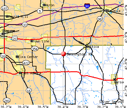
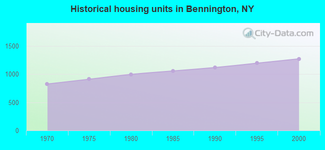
Bennington, New York
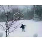
Bennington: Snowshoe trek to the chicken coop in Bennington, N. Y..
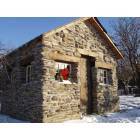
Bennington: Stone chicken coop in Bennington, N. Y..
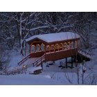
Bennington: Snowmobile Trail Covered Bridge Bennington NY
- add
your
Submit your own pictures of this town and show them to the world
- OSM Map
- General Map
- Google Map
- MSN Map
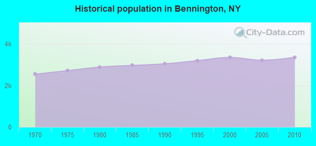
Population change since 2000: +0.3%
 |
| Males: 1,736 | |
| Females: 1,623 |
| Median resident age: | 45.6 years |
| New York median age: | 40.7 years |
Zip codes: 14011.
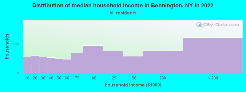
| Bennington: | $72,457 |
| NY: | $79,557 |
Estimated per capita income in 2022: $37,464 (it was $18,247 in 2000)
Bennington town income, earnings, and wages data
Estimated median house or condo value in 2022: $191,433 (it was $96,700 in 2000)
| Bennington: | $191,433 |
| NY: | $400,400 |
Mean prices in 2022: all housing units: $186,586; detached houses: $187,038; townhouses or other attached units: $267,158; in 2-unit structures: $247,178; in 3-to-4-unit structures: $41,140; mobile homes: $75,293
Detailed information about poverty and poor residents in Bennington, NY


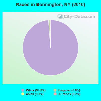
- 3,31898.8%White alone
- 260.8%Hispanic
- 60.2%Asian alone
- 60.2%Two or more races
- 30.09%American Indian alone
Races in Bennington detailed stats: ancestries, foreign born residents, place of birth
 Recent articles from our blog. Our writers, many of them Ph.D. graduates or candidates, create easy-to-read articles on a wide variety of topics.


Latest news from Bennington, NY collected exclusively by city-data.com from local newspapers, TV, and radio stations
Ancestries: German (41.1%), Polish (21.9%), Irish (13.9%), English (12.3%), Italian (8.0%), Dutch (4.3%).
Current Local Time: EST time zone
Elevation: 1208 feet
Land area: 55.0 square miles.
Population density: 61 people per square mile (very low).
42 residents are foreign born
| This town: | 1.3% |
| New York: | 20.4% |
| Bennington town: | 2.0% ($1,955) |
| New York: | 1.9% ($2,847) |
Nearest city with pop. 50,000+: Cheektowaga, NY  (18.5 miles , pop. 79,988).
Nearest city with pop. 200,000+: Buffalo, NY (22.7 miles , pop. 292,648).
Nearest city with pop. 1,000,000+: Philadelphia, PA (259.0 miles , pop. 1,517,550).
Nearest cities:
), ), ), ), ), )Latitude: 42.83 N, Longitude: 78.41 W
Area code commonly used in this area: 585

| Here: | 5.0% |
| New York: | 4.4% |
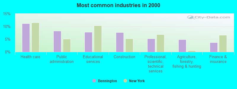
- Health care (11.2%)
- Public administration (8.2%)
- Educational services (7.8%)
- Construction (7.6%)
- Professional, scientific, technical services (5.3%)
- Agriculture, forestry, fishing & hunting (4.9%)
- Finance & insurance (3.7%)
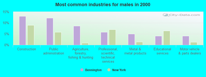
- Construction (13.1%)
- Public administration (12.2%)
- Agriculture, forestry, fishing & hunting (8.6%)
- Professional, scientific, technical services (5.9%)
- Metal & metal products (5.0%)
- Educational services (4.1%)
- Motor vehicle & parts dealers (4.1%)
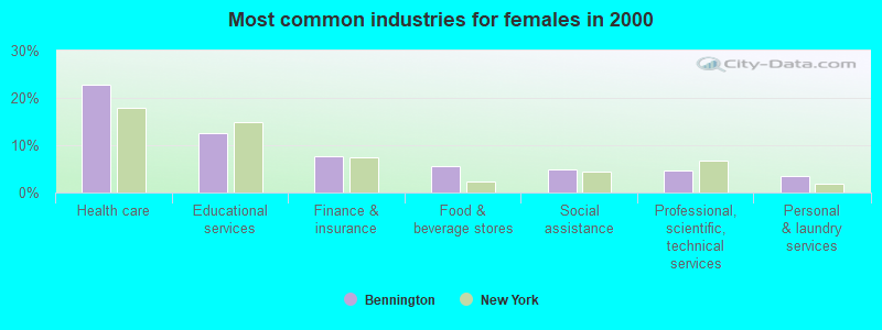
- Health care (22.9%)
- Educational services (12.5%)
- Finance & insurance (7.7%)
- Food & beverage stores (5.7%)
- Social assistance (4.8%)
- Professional, scientific, technical services (4.5%)
- Personal & laundry services (3.4%)
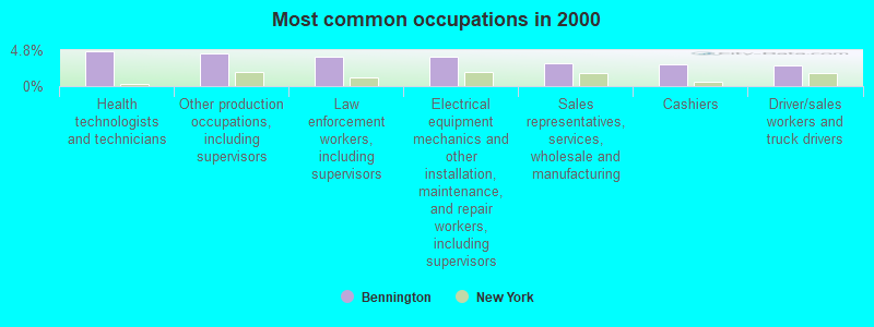
- Health technologists and technicians (4.7%)
- Other production occupations, including supervisors (4.3%)
- Law enforcement workers, including supervisors (3.9%)
- Electrical equipment mechanics and other installation, maintenance, and repair workers, including supervisors (3.9%)
- Sales representatives, services, wholesale and manufacturing (3.0%)
- Cashiers (2.9%)
- Driver/sales workers and truck drivers (2.8%)
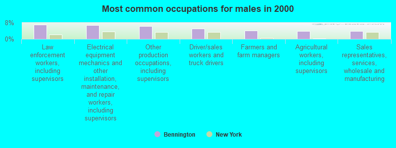
- Law enforcement workers, including supervisors (7.0%)
- Electrical equipment mechanics and other installation, maintenance, and repair workers, including supervisors (6.9%)
- Other production occupations, including supervisors (6.4%)
- Driver/sales workers and truck drivers (5.0%)
- Farmers and farm managers (4.1%)
- Agricultural workers, including supervisors (3.9%)
- Sales representatives, services, wholesale and manufacturing (3.9%)
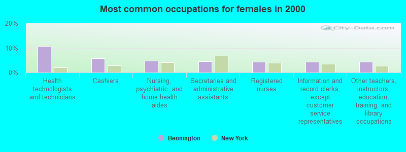
- Health technologists and technicians (10.8%)
- Cashiers (5.8%)
- Nursing, psychiatric, and home health aides (4.7%)
- Secretaries and administrative assistants (4.5%)
- Registered nurses (4.4%)
- Information and record clerks, except customer service representatives (4.3%)
- Other teachers, instructors, education, training, and library occupations (4.3%)
Average climate in Bennington, New York
Based on data reported by over 4,000 weather stations


(lower is better)
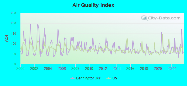
Air Quality Index (AQI) level in 2023 was 86.0. This is about average.
| City: | 86.0 |
| U.S.: | 72.6 |
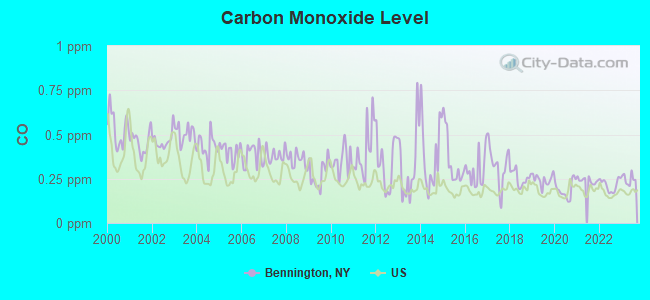
Carbon Monoxide (CO) [ppm] level in 2023 was 0.248. This is about average. Closest monitor was 20.3 miles away from the city center.
| City: | 0.248 |
| U.S.: | 0.251 |
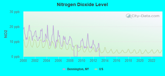
Nitrogen Dioxide (NO2) [ppb] level in 2012 was 6.43. This is worse than average. Closest monitor was 20.3 miles away from the city center.
| City: | 6.43 |
| U.S.: | 5.11 |
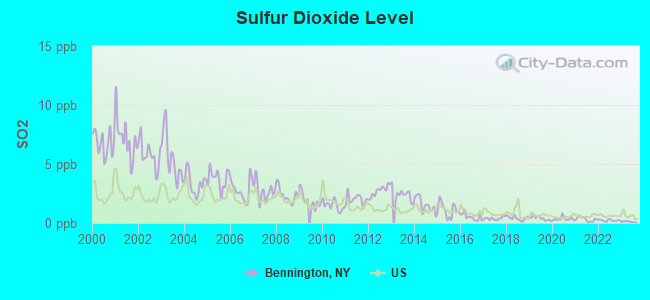
Sulfur Dioxide (SO2) [ppb] level in 2023 was 0.107. This is significantly better than average. Closest monitor was 13.7 miles away from the city center.
| City: | 0.107 |
| U.S.: | 1.515 |
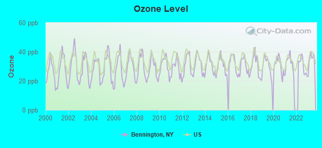
Ozone [ppb] level in 2023 was 33.8. This is about average. Closest monitor was 20.3 miles away from the city center.
| City: | 33.8 |
| U.S.: | 33.3 |
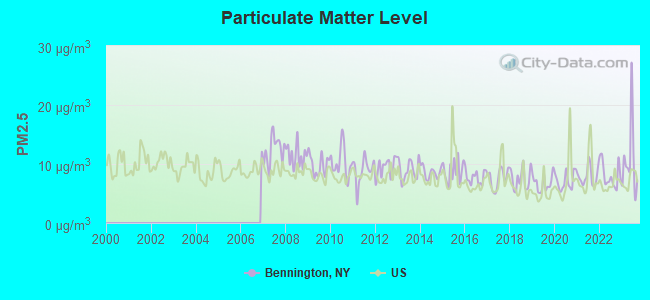
Particulate Matter (PM2.5) [µg/m3] level in 2023 was 10.6. This is worse than average. Closest monitor was 20.3 miles away from the city center.
| City: | 10.6 |
| U.S.: | 8.1 |
Tornado activity:
Bennington-area historical tornado activity is slightly below New York state average. It is 72% smaller than the overall U.S. average.
On 8/19/1970, a category F3 (max. wind speeds 158-206 mph) tornado 23.4 miles away from the Bennington town center injured 3 people and caused between $50,000 and $500,000 in damages.
On 7/24/1967, a category F3 tornado 31.2 miles away from the town center caused between $5000 and $50,000 in damages.
Earthquake activity:
Bennington-area historical earthquake activity is significantly above New York state average. It is 67% smaller than the overall U.S. average.On 9/25/1998 at 19:52:52, a magnitude 5.2 (4.8 MB, 4.3 MS, 5.2 LG, 4.5 MW, Depth: 3.1 mi, Class: Moderate, Intensity: VI - VII) earthquake occurred 137.5 miles away from the city center
On 10/7/1983 at 10:18:46, a magnitude 5.3 (5.1 MB, 5.3 LG, 5.1 ML) earthquake occurred 218.9 miles away from the city center
On 1/31/1986 at 16:46:43, a magnitude 5.0 (5.0 MB) earthquake occurred 164.3 miles away from Bennington center
On 8/23/2011 at 17:51:04, a magnitude 5.8 (5.8 MW, Depth: 3.7 mi) earthquake occurred 341.2 miles away from the city center
On 4/20/2002 at 10:50:47, a magnitude 5.3 (5.3 ML, Depth: 3.0 mi) earthquake occurred 263.1 miles away from the city center
On 4/20/2002 at 10:50:47, a magnitude 5.2 (5.2 MB, 4.2 MS, 5.2 MW, 5.0 MW) earthquake occurred 261.4 miles away from Bennington center
Magnitude types: regional Lg-wave magnitude (LG), body-wave magnitude (MB), local magnitude (ML), surface-wave magnitude (MS), moment magnitude (MW)
Natural disasters:
The number of natural disasters in Wyoming County (20) is greater than the US average (15).Major Disasters (Presidential) Declared: 11
Emergencies Declared: 9
Causes of natural disasters: Storms: 7, Floods: 6, Snowstorms: 4, Winter Storms: 4, Tornadoes: 3, Hurricanes: 2, Blizzard: 1, Ice Storm: 1, Power Outage: 1, Tropical Storm: 1, Wind: 1, Other: 2 (Note: some incidents may be assigned to more than one category).
Hospitals and medical centers near Bennington:
- ERIE CO HOME INFIRMARY (Nursing Home, about 11 miles away; ALDEN, NY)
- ERIE COUNTY HOME (Nursing Home, about 11 miles away; ALDEN, NY)
- ABSOLUT CTR FOR NURSING AND REHAB AURORA PARK L L C (Nursing Home, about 12 miles away; EAST AURORA, NY)
- GREENFIELD HEALTH AND REHABILITATION CENTER (Nursing Home, about 12 miles away; LANCASTER, NY)
- BROTHERS OF MERCY NURSING AND REHABILITATION CENTER (Nursing Home, about 14 miles away; CLARENCE, NY)
- ELDERWOOD HEALTH CARE AT LINWOOD (Nursing Home, about 15 miles away; LANCASTER, NY)
- WYOMING COUNTY COMMUNITY HOSPITAL Acute Care Hospitals (about 16 miles away; WARSAW, NY)
Colleges/universities with over 2000 students nearest to Bennington:
- Bryant & Stratton College-Online (about 19 miles; Orchard Park, NY; Full-time enrollment: 2,212)
- Genesee Community College (about 20 miles; Batavia, NY; FT enrollment: 4,290)
- Daemen College (about 22 miles; Amherst, NY; FT enrollment: 2,365)
- University at Buffalo (about 23 miles; Buffalo, NY; FT enrollment: 25,415)
- Canisius College (about 24 miles; Buffalo, NY; FT enrollment: 4,376)
- Medaille College (about 24 miles; Buffalo, NY; FT enrollment: 2,361)
- Erie Community College (about 24 miles; Buffalo, NY; FT enrollment: 11,035)
Points of interest:
Notable locations in Bennington: Quiet Times Golf Course (A), Ironwood Golf Course (B), Camp Schoellkopf (C), Bennington Volunteer Fire Company (D), Cowlesville Fire Company (E). Display/hide their locations on the map
Churches in Bennington include: Cowlesville Baptist Church (A), Folsomdale Baptist Church (B), Salem United Church of Christ (C), Sacred Heart Roman Catholic Church (D). Display/hide their locations on the map
Cemeteries: Summit View Cemetery (1), Cowlesville Village Cemetery (2), Sacred Heart Cemetery (3), East Bennington German Cemetery (4), Folsomdale Cemetery (5), Fairview Cemetery (6), Maple Lawn Cemetery (7). Display/hide their locations on the map
Reservoirs: Akron Reservoir (A), Matts Pond (B). Display/hide their locations on the map
Streams, rivers, and creeks: Gillett Creek (A), French Brook (B), Fenton Creek (C), Red Brook (D), Right Branch Cayuga Creek (E), Johnson Creek (F). Display/hide their locations on the map
Birthplace of: Justin Rolph Loomis - University president.
| This town: | 2.6 people |
| New York: | 2.6 people |
| This town: | 75.5% |
| Whole state: | 63.5% |
| This town: | 6.6% |
| Whole state: | 6.8% |
Likely homosexual households (counted as self-reported same-sex unmarried-partner households)
- Lesbian couples: 0.3% of all households
- Gay men: 0.2% of all households
| This town: | 6.2% |
| Whole state: | 14.6% |
| This town: | 2.1% |
| Whole state: | 7.4% |
For population 15 years and over in Bennington:
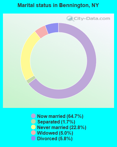
- Never married: 22.8%
- Now married: 64.7%
- Separated: 1.7%
- Widowed: 5.0%
- Divorced: 5.8%
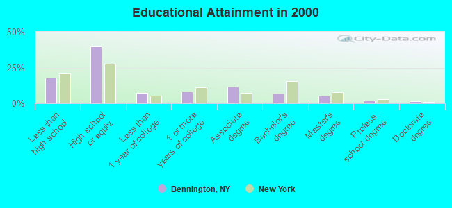
For population 25 years and over in Bennington:
- High school or higher: 82.2%
- Bachelor's degree or higher: 15.0%
- Graduate or professional degree: 8.3%
- Unemployed: 7.1%
- Mean travel time to work (commute): 28.0 minutes
| Here: | 10.4 |
| New York average: | 14.2 |
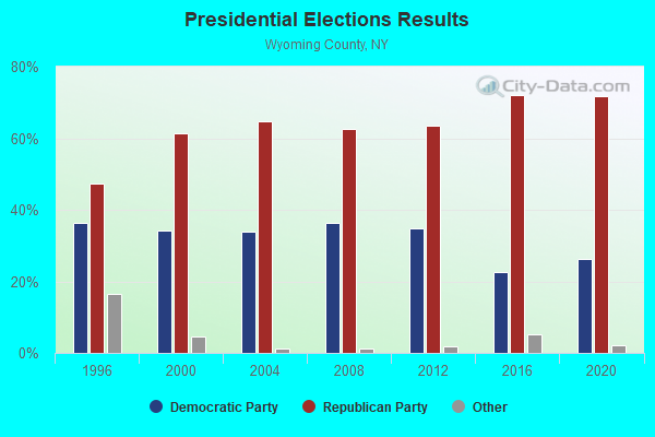
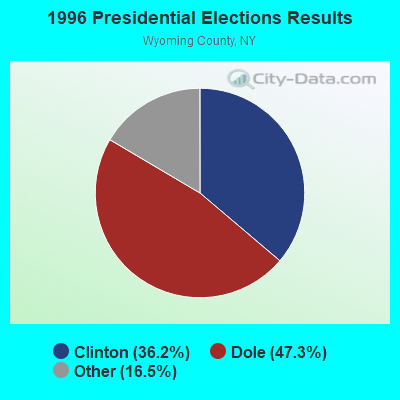

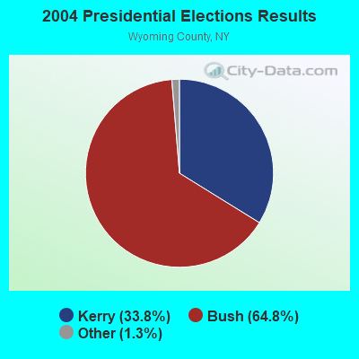
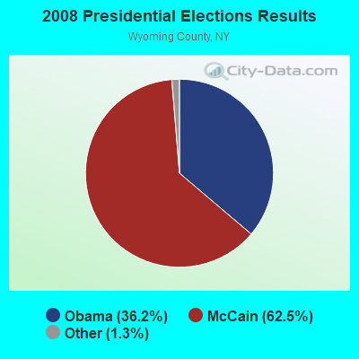
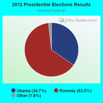
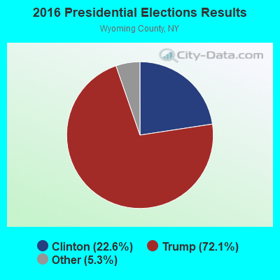
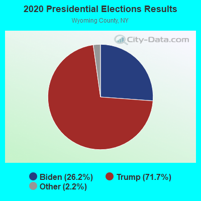
Graphs represent county-level data. Detailed 2008 Election Results
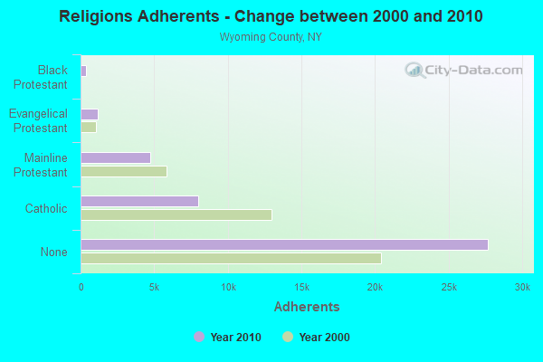
Religion statistics for Bennington, NY (based on Wyoming County data)
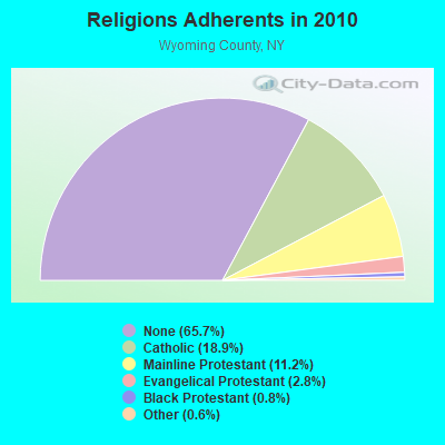
| Religion | Adherents | Congregations |
|---|---|---|
| Catholic | 7,968 | 5 |
| Mainline Protestant | 4,716 | 30 |
| Evangelical Protestant | 1,168 | 24 |
| Black Protestant | 354 | 1 |
| Other | 249 | 2 |
| None | 27,700 | - |
Food Environment Statistics:
| Wyoming County: | 2.15 / 10,000 pop. |
| New York: | 4.13 / 10,000 pop. |
| Wyoming County: | 0.96 / 10,000 pop. |
| New York: | 0.92 / 10,000 pop. |
| This county: | 4.54 / 10,000 pop. |
| New York: | 1.68 / 10,000 pop. |
| Wyoming County: | 6.93 / 10,000 pop. |
| State: | 8.82 / 10,000 pop. |
| This county: | 8.5% |
| New York: | 8.2% |
| Here: | 26.3% |
| New York: | 23.8% |
| Wyoming County: | 13.6% |
| New York: | 15.6% |
Strongest AM radio stations in Bennington:
- WWKB (1520 AM; 50 kW; BUFFALO, NY; Owner: ENTERCOM BUFFALO LICENSE, LLC)
- WXRL (1300 AM; 5 kW; LANCASTER, NY; Owner: DOME BROADCASTING, INC.)
- WHAM (1180 AM; 50 kW; ROCHESTER, NY; Owner: CITICASTERS LICENSES, L.P.)
- WGR (550 AM; 5 kW; BUFFALO, NY; Owner: ENTERCOM BUFFALO LICENSE, LLC)
- WNED (970 AM; 5 kW; BUFFALO, NY)
- WTOR (770 AM; daytime; 9 kW; YOUNGSTOWN, NY; Owner: BIRACH BROADCASTING CORPORATION)
- WCJW (1140 AM; daytime; 2 kW; WARSAW, NY; Owner: LLOYD LANE, INCORPORATED)
- WHLD (1270 AM; 5 kW; NIAGARA FALLS, NY; Owner: CITADEL BROADCASTING COMPANY)
- WBEN (930 AM; 5 kW; BUFFALO, NY; Owner: ENTERCOM BUFFALO LICENSE, LLC)
- WLGZ (990 AM; 5 kW; ROCHESTER, NY; Owner: KIMTRON, INC.)
- WJJL (1440 AM; 5 kW; NIAGARA FALLS, NY; Owner: M.J. PHILLIPS COMMUNICATIONS, INC.)
- WBTA (1490 AM; 1 kW; BATAVIA, NY; Owner: BRO-BEN COMMUNICATIONS, INC.)
- WMNY (1120 AM; daytime; 1 kW; BUFFALO, NY; Owner: CITADEL BROADCASTING COMPANY)
Strongest FM radio stations in Bennington:
- WLOF (101.7 FM; ATTICA, NY; Owner: HOLY FAMILY COMMUNICATIONS, INC.)
- WTSS (102.5 FM; BUFFALO, NY; Owner: ENTERCOM BUFFALO LICENSE, LLC)
- WCOU (88.3 FM; WARSAW, NY; Owner: FAMILY LIFE MINISTRIES, INC.)
- WNSA (107.7 FM; WETHERSFIELD TWNSHP, NY; Owner: ADELPHIA COMMUNICATIONS CORPORATION, DEBTOR-IN-POSSESSION)
- WGRF (96.9 FM; BUFFALO, NY; Owner: CITADEL BROADCASTING COMPANY)
- WBUF (92.9 FM; BUFFALO, NY; Owner: INFINITY RADIO OPERATIONS INC.)
- WNED-FM (94.5 FM; BUFFALO, NY; Owner: WESTERN NEW YORK PUBLIC B/C ASSOC.)
- WDCX (99.5 FM; BUFFALO, NY; Owner: KIMTRON, INC.)
- WFBF (89.9 FM; BUFFALO, NY; Owner: FAMILY STATIONS, INC.)
- WBLK (93.7 FM; DEPEW, NY; Owner: INFINITY RADIO OPERATIONS INC.)
- WJYE (96.1 FM; BUFFALO, NY; Owner: INFINITY RADIO OPERATIONS INC.)
- WHTT-FM (104.1 FM; BUFFALO, NY; Owner: CITADEL BROADCASTING COMPANY)
- WYRK (106.5 FM; BUFFALO, NY; Owner: INFINITY RADIO OPERATIONS INC.)
- WEDG (103.3 FM; BUFFALO, NY; Owner: CITADEL BROADCASTING COMPANY)
- DW208AM (89.5 FM; BATAVIA, NY; Owner: AMERICAN FAMILY ASSOCIATION)
- W284AP (104.7 FM; BUFFALO, NY; Owner: FAMILY LIFE MINISTRIES, INC.)
- WBFO (88.7 FM; BUFFALO, NY; Owner: STATE UNIVERSITY OF NEW YORK)
TV broadcast stations around Bennington:
- WNYO-TV (Channel 49; BUFFALO, NY; Owner: NEW YORK TELEVISION, INC.)
- WGRZ-TV (Channel 2; BUFFALO, NY; Owner: MULTIMEDIA ENTERTAINMENT, INC.)
- WKBW-TV (Channel 7; BUFFALO, NY; Owner: WKBW-TV LICENSE, INC.)
- WIVB-TV (Channel 4; BUFFALO, NY; Owner: WIVB BROADCASTING, LLC)
- WPXJ-TV (Channel 51; BATAVIA, NY; Owner: PAXSON BUFFALO LICENSE, INC.)
- WNED-TV (Channel 17; BUFFALO, NY; Owner: WESTERN NY PUBLIC BROADCASTING ASSOC.)
- WUTV (Channel 29; BUFFALO, NY; Owner: WUTV LICENSEE, LLC)
- WNLO (Channel 23; BUFFALO, NY; Owner: WIVB BROADCASTING, LLC)
- WNGS (Channel 67; SPRINGVILLE, NY; Owner: CAROLINE K. POWLEY D/B/A UNICORN/SPRINGVILLE)
- WDTB-LP (Channel 39; HAMBURG, NY; Owner: WORD OF GOD FELLOWSHIP, INC.)
- WFHW-LP (Channel 58; BUFFALO, NY; Owner: CITIZENS TELEVISION SYSTEM, INC.)
- WBXZ-LP (Channel 56; BUFFALO, NY; Owner: RENARD COMMUNICATIONS CORP.)
- WBNF-CA (Channel 15; BUFFALO, NY; Owner: FAITH BROADCASTING NETWORK, INC.)
- National Bridge Inventory (NBI) Statistics
- 18Number of bridges
- 125ft / 37.9mTotal length
- $23,211,000Total costs
- 41,962Total average daily traffic
- 1,901Total average daily truck traffic
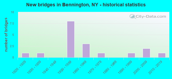
- New bridges - historical statistics
- 11920-1929
- 11930-1939
- 81950-1959
- 31960-1969
- 11970-1979
- 11990-1999
- 22000-2009
- 12010-2019
FCC Registered Antenna Towers:
4- James N Wright, North Of Steadman Road, 1.2 Km East Of Tinkham Road (Lat: 42.847556 Lon: -78.350000), Type: 96.0, Overall height: 94 m, Registrant: Law Office Of Dennis J. Kelly, Dkellyfcclaw1@comcast.Net, , 41177 Washi-ngton, Phone: (888) 322-5291
- KEVIN P DORAN, North Of Steadman Road, 1.2 Km East Of Tinkham Road (Lat: 42.847556 Lon: -78.350000), Type: 96.0, Overall height: 94 m, Registrant: Bro-Ben Communications, Inc., Batav-ia, Phone: (716) 344-1490
- James N Wright, North Of Steadman Road, 1.2 Km East Of Tinkham Road (Lat: 42.847556 Lon: -78.350000), Type: 96.0, Overall height: 94 m, Registrant: Holy Family Communications, Jimw@wlof.Net, , 745 Amher-st, Phone: (716) 839-6117
- James N Wright, North Of Steadman Road, 1.2 Km East Of Tinkham Road (Lat: 42.847556 Lon: -78.350000), Type: 96.0, Overall height: 94 m, Registrant: Law Office Of Dennis J. Kelly, Dkellyfcclaw1@comcast.Net, , 41177 Washi-ngton, Phone: (888) 322-5291
FCC Registered Paging Towers:
1- Steadman Rd., 0.8 Miles East Of Tinkham Rd Near Attica (Lat: 42.847556 Lon: -78.350000), Call Sign: KEA777,
Assigned Frequencies: 35.5800 MHz, 35.5800 MHz, Expiration Date: 04/01/1999, Cancellation Date: 03/16/1999, Registrant: Mobilemedia Communications, Inc., Debtor-In-Possession, 2101 Wilson Boulevard, Suite 935, Arlington, VA 22201, Phone: (703) 312-5153, Fax: (703) 312-5155, Email:
FCC Registered Amateur Radio Licenses:
2- Call Sign: KB2JCW, Licensee ID: L00194748, Grant Date: 01/13/2000, Expiration Date: 03/06/2010, Cancellation Date: 03/07/2012, Registrant: George E Torge, 1097 Graff Rd, Bennington, NY 14011
- Call Sign: N2MHE, Licensee ID: L00373666, Grant Date: 05/09/2011, Expiration Date: 07/16/2021, Cancellation Date: 07/18/2023, Certifier: Robert W Gadd, Registrant: Robert W Gadd, 1339 Clinton St, Bennington, NY 14011
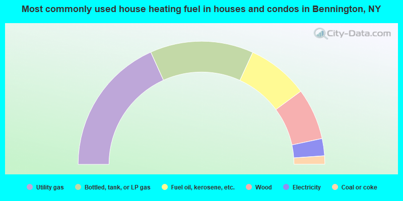
- 36.5%Utility gas
- 27.1%Bottled, tank, or LP gas
- 16.1%Fuel oil, kerosene, etc.
- 13.5%Wood
- 4.5%Electricity
- 2.2%Coal or coke
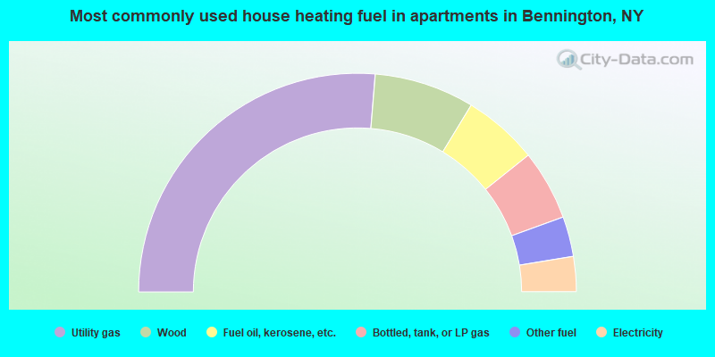
- 52.6%Utility gas
- 14.8%Wood
- 11.1%Fuel oil, kerosene, etc.
- 10.4%Bottled, tank, or LP gas
- 5.9%Other fuel
- 5.2%Electricity
Bennington compared to New York state average:
- Median house value below state average.
- Unemployed percentage below state average.
- Black race population percentage significantly below state average.
- Hispanic race population percentage significantly below state average.
- Median age above state average.
- Foreign-born population percentage significantly below state average.
- Renting percentage significantly below state average.
- Length of stay since moving in significantly above state average.
- Number of rooms per house significantly below state average.
- House age significantly below state average.
- Number of college students below state average.
- Percentage of population with a bachelor's degree or higher below state average.