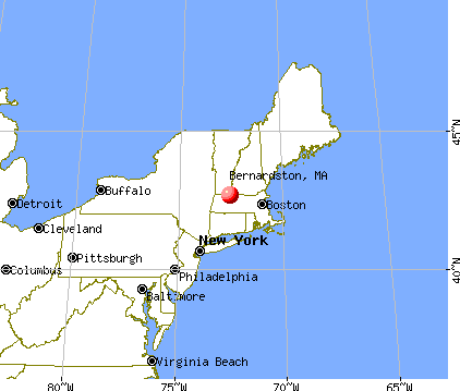
Bernardston, Massachusetts
Submit your own pictures of this town and show them to the world
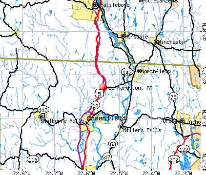
- OSM Map
- General Map
- Google Map
- MSN Map
Population change since 2000: -1.2%
 |
| Males: 1,065 | |
| Females: 1,064 |
| Median resident age: | 47.7 years |
| Massachusetts median age: | 39.2 years |
Zip codes: 01337.
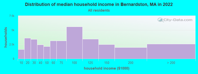
| Bernardston: | $78,051 |
| MA: | $94,488 |
Estimated per capita income in 2022: $38,186 (it was $20,959 in 2000)
Bernardston town income, earnings, and wages data
Estimated median house or condo value in 2022: $299,215 (it was $120,400 in 2000)
| Bernardston: | $299,215 |
| MA: | $534,700 |
Mean prices in 2022: all housing units: $313,377; detached houses: $324,224; townhouses or other attached units: $284,225; in 2-unit structures: $287,978; in 3-to-4-unit structures: $183,938; in 5-or-more-unit structures: $249,762; mobile homes: $62,200
Detailed information about poverty and poor residents in Bernardston, MA
Compare current foreclosures near Bernardston, MA:
| Photo | Address | Area | Beds / Baths | Price | Details |
|---|---|---|---|---|---|

|
#1
Hillcrest Dr
Bernardston, MA 01337
|
1,120 sq. feet
|
1 baths 3 beds |
show details | |

|
#2
Lampblack Rd
Greenfield, MA 01301
|
2,078 sq. feet
|
1 baths 3 beds |
$355,000
|
show details |

|
#3
Elmer Rd
Conway, MA 01341
|
1,866 sq. feet
|
3 baths 3 beds |
show details | |

|
#4
Poocham Rd
West Chesterfield, NH 03466
|
1,282 sq. feet
|
1 baths 3 beds |
show details | |

|
#5
N Orange Rd
Athol, MA 01331
|
950 sq. feet
|
1 baths 3 beds |
show details | |

|
#6
Aldrich St
Northfield, MA 01360
|
2,486 sq. feet
|
2 baths 5 beds |
show details | |

|
#7
West St
Greenfield, MA 01301
|
1,858 sq. feet
|
2 baths 3 beds |
show details | |

|
#8
S Main St
Athol, MA 01331
|
1,805 sq. feet
|
2 baths 2 beds |
show details | |

|
#9
Graves Rd
Conway, MA 01341
|
1,440 sq. feet
|
1 baths 3 beds |
show details | |

|
#10
Pine St
Brattleboro, VT 05301
|
2,906 sq. feet
|
2 baths 5 beds |
show details |
| Photo | Address | Area | Beds / Baths | Price | Details |
|---|---|---|---|---|---|

|
#11
N Main St
New Salem, MA 01355
|
2,304 sq. feet
|
2 baths 3 beds |
show details | |

|
#12
Sabans Rd
Conway, MA 01341
|
1,246 sq. feet
|
2 baths 3 beds |
show details | |

|
#13
Tully Rd
Orange, MA 01364
|
1,532 sq. feet
|
1 baths 3 beds |
show details | |

|
#14
Leverett Rd
Shutesbury, MA 01072
|
1,131 sq. feet
|
1 baths 3 beds |
show details | |

|
#15
Brickyard Rd
Athol, MA 01331
|
1,685 sq. feet
|
2 baths 4 beds |
show details | |

|
#16
Mechanic St
Winchester, NH 03470
|
1,918 sq. feet
|
2 baths 4 beds |
show details | |

|
#17
Stone Rd
Orange, MA 01364
|
1,312 sq. feet
|
1 baths 3 beds |
show details | |

|
#18
Dwight Cross Rd
Colrain, MA 01340
|
1,092 sq. feet
|
1 baths 3 beds |
show details | |

|
#19
W Main St
New Salem, MA 01355
|
4,624 sq. feet
|
3 baths 6 beds |
show details | |

|
#20
Daniel Shays Hwy
Athol, MA 01331
|
1,736 sq. feet
|
2 baths 4 beds |
show details |
| Photo | Address | Area | Beds / Baths | Price | Details |
|---|---|---|---|---|---|

|
#21
Maynard St
Orange, MA 01364
|
1,640 sq. feet
|
2 baths 3 beds |
show details | |

|
#22
Hillside Rd
South Deerfield, MA 01373
|
1,449 sq. feet
|
2 baths 3 beds |
show details | |

|
#23
Lake Mattawa Rd
Orange, MA 01364
|
1,666 sq. feet
|
1 baths 3 beds |
show details | |

|
#24
N Main St, Unit A
Orange, MA 01364
|
598 sq. feet
|
1 baths 2 beds |
show details | |

|
#25
School St
Orange, MA 01364
|
1,716 sq. feet
|
1 baths 3 beds |
show details | |

|
#26
Spring St
Orange, MA 01364
|
868 sq. feet
|
1 baths 1 beds |
show details | |

|
#27
Briggs Rd
Shutesbury, MA 01072
|
1,434 sq. feet
|
1 baths 3 beds |
show details | |

|
#28
Eddy St
Orange, MA 01364
|
1,116 sq. feet
|
1 baths 2 beds |
show details | |

|
#29
E River St
Orange, MA 01364
|
1,332 sq. feet
|
1 baths 3 beds |
show details | |

|
#30
Old South Rd
Orange, MA 01364
|
1,078 sq. feet
|
1 baths 3 beds |
show details |
| Photo | Address | Area | Beds / Baths | Price | Details |
|---|---|---|---|---|---|

|
#31
Sandrah Dr
Orange, MA 01364
|
960 sq. feet
|
1 baths 3 beds |
show details | |

|
#32
Prescott Ln
Orange, MA 01364
|
2,064 sq. feet
|
2 baths 3 beds |
show details | |

|
#33
Chesterfield Rd
Hinsdale, NH 03451
|
1,796 sq. feet
|
1 baths 3 beds |
show details | |

|
#34
East Rd
Orange, MA 01364
|
960 sq. feet
|
1 baths 3 beds |
show details | |

|
#35
Griswoldville St
Colrain, MA 01340
|
1,272 sq. feet
|
2 baths 5 beds |
show details | |

|
#36
Chapman St
Greenfield, MA 01301
|
1,472 sq. feet
|
1 baths 2 beds |
show details | |

|
#37
Log Plain Rd
Greenfield, MA 01301
|
960 sq. feet
|
1 baths 3 beds |
show details | |

|
#38
Boyle Rd
Northfield, MA 01354
|
1,500 sq. feet
|
2 baths 3 beds |
show details | |

|
#39
Walnut St
Northfield, MA 01354
|
1,704 sq. feet
|
2 baths 4 beds |
show details | |

|
#40
French King Hwy
Greenfield, MA 01301
|
1,040 sq. feet
|
1 baths 5 beds |
show details |
| Photo | Address | Area | Beds / Baths | Price | Details |
|---|---|---|---|---|---|

|
#41
5th St
Turners Falls, MA 01376
|
1,683 sq. feet
|
2 baths 4 beds |
show details | |

|
#42
New Plain Rd
Northfield, MA 01360
|
2,370 sq. feet
|
2 baths 2 beds |
show details | |

|
#43
Plumtree Rd
Sunderland, MA 01375
|
1,536 sq. feet
|
2 baths 2 beds |
show details | |

|
#44
Central St
Turners Falls, MA 01376
|
1,506 sq. feet
|
1 baths 3 beds |
show details | |

|
#45
South St
Athol, MA 01331
|
1,135 sq. feet
|
1 baths 3 beds |
show details | |

|
#46
Grove St
Turners Falls, MA 01376
|
2,273 sq. feet
|
1 baths 4 beds |
show details | |

|
#47
Main St
Northfield, MA 01360
|
6,076 sq. feet
|
2 baths 9 beds |
show details | |

|
#48
Forest Ave
Greenfield, MA 01301
|
1,764 sq. feet
|
1 baths 4 beds |
show details | |

|
#49
Rogers Ave
Orange, MA 01364
|
1,296 sq. feet
|
1 baths 3 beds |
show details | |

|
Check over 1 million property listings on Foreclosure.com!
|
browse all offers | |||

- 2,07097.2%White alone
- 251.2%Two or more races
- 170.8%Hispanic
- 100.5%Asian alone
- 40.2%Black alone
- 30.1%American Indian alone
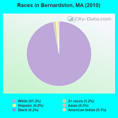
Races in Bernardston detailed stats: ancestries, foreign born residents, place of birth
According to our research of Massachusetts and other state lists, there were 2 registered sex offenders living in Bernardston, Massachusetts as of June 15, 2024.
The ratio of all residents to sex offenders in Bernardston is 1,065 to 1.
Type |
2009 |
2010 |
2011 |
2012 |
2013 |
2014 |
2015 |
2016 |
2017 |
2018 |
2019 |
2020 |
2021 |
2022 |
|---|---|---|---|---|---|---|---|---|---|---|---|---|---|---|
| Murders (per 100,000) | 0 (0.0) | 0 (0.0) | 0 (0.0) | 0 (0.0) | 0 (0.0) | 0 (0.0) | 0 (0.0) | 0 (0.0) | 0 (0.0) | 0 (0.0) | 0 (0.0) | 0 (0.0) | 0 (0.0) | 0 (0.0) |
| Rapes (per 100,000) | 0 (0.0) | 0 (0.0) | 0 (0.0) | 0 (0.0) | 0 (0.0) | 0 (0.0) | 0 (0.0) | 1 (47.7) | 1 (48.0) | 0 (0.0) | 3 (142.0) | 0 (0.0) | 1 (48.0) | 1 (35.1) |
| Robberies (per 100,000) | 0 (0.0) | 0 (0.0) | 0 (0.0) | 0 (0.0) | 1 (46.8) | 0 (0.0) | 1 (47.4) | 0 (0.0) | 0 (0.0) | 0 (0.0) | 0 (0.0) | 0 (0.0) | 0 (0.0) | 1 (35.1) |
| Assaults (per 100,000) | 2 (88.6) | 1 (47.0) | 4 (186.7) | 4 (185.7) | 3 (140.4) | 0 (0.0) | 2 (94.8) | 1 (47.7) | 0 (0.0) | 4 (189.8) | 2 (94.7) | 5 (239.7) | 2 (95.9) | 0 (0.0) |
| Burglaries (per 100,000) | 8 (354.3) | 7 (328.8) | 7 (326.8) | 13 (603.5) | 2 (93.6) | 11 (518.4) | 2 (94.8) | 4 (190.8) | 8 (384.2) | 7 (332.1) | 3 (142.0) | 1 (47.9) | 4 (191.8) | 2 (70.3) |
| Thefts (per 100,000) | 15 (664.3) | 15 (704.6) | 5 (233.4) | 15 (696.4) | 11 (515.0) | 5 (235.6) | 11 (521.3) | 12 (572.5) | 20 (960.6) | 12 (569.3) | 9 (425.9) | 10 (479.4) | 13 (623.5) | 7 (246.0) |
| Auto thefts (per 100,000) | 2 (88.6) | 0 (0.0) | 1 (46.7) | 0 (0.0) | 2 (93.6) | 2 (94.3) | 3 (142.2) | 2 (95.4) | 0 (0.0) | 3 (142.3) | 0 (0.0) | 1 (47.9) | 6 (287.8) | 1 (35.1) |
| Arson (per 100,000) | 0 (0.0) | 1 (47.0) | 1 (46.7) | 0 (0.0) | 0 (0.0) | 0 (0.0) | 0 (0.0) | 0 (0.0) | 0 (0.0) | 0 (0.0) | 0 (0.0) | 0 (0.0) | 0 (0.0) | 0 (0.0) |
| City-Data.com crime index | 76.2 | 60.6 | 73.3 | 107.2 | 76.8 | 53.3 | 72.0 | 91.6 | 103.7 | 95.4 | 159.5 | 74.3 | 118.9 | 56.2 |
The City-Data.com crime index weighs serious crimes and violent crimes more heavily. Higher means more crime, U.S. average is 246.1. It adjusts for the number of visitors and daily workers commuting into cities.
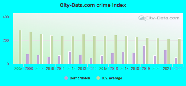
Crime rate in Bernardston detailed stats: murders, rapes, robberies, assaults, burglaries, thefts, arson
Full-time law enforcement employees in 2021, including police officers: 3 (3 officers - 3 male; 0 female).
| Officers per 1,000 residents here: | 1.44 |
| Massachusetts average: | 2.53 |
 Recent articles from our blog. Our writers, many of them Ph.D. graduates or candidates, create easy-to-read articles on a wide variety of topics.

 | Big MA Ancestry Data Thread by Town (31 replies) |
| How Much Massachusetts Households Make Per Year: Census Data (37 replies) |
| Old Farm but New Needs (95 replies) |
| Commute to Springfield: easier from Berkshires or NH? (22 replies) |
| Advice on Pioneer Valley towns (46 replies) |
| Massachusetts Hilltowns (17 replies) |
Latest news from Bernardston, MA collected exclusively by city-data.com from local newspapers, TV, and radio stations
Ancestries: English (19.6%), French (13.3%), Polish (12.6%), Irish (12.2%), German (9.6%), French Canadian (8.2%).
Current Local Time: EST time zone
Incorporated in 1762
Elevation: 360 feet
Land area: 23.4 square miles.
Population density: 91 people per square mile (very low).
18 residents are foreign born
| This town: | 0.8% |
| Massachusetts: | 12.2% |
| Bernardston town: | 1.6% ($1,937) |
| Massachusetts: | 1.3% ($2,336) |
Nearest city with pop. 50,000+: Chicopee, MA  (35.1 miles , pop. 54,653).
Nearest city with pop. 200,000+: Boston, MA (78.3 miles , pop. 589,141).
Nearest city with pop. 1,000,000+: Bronx, NY (143.9 miles , pop. 1,332,650).
Nearest cities:
), )Latitude: 42.68 N, Longitude: 72.55 W
Area code: 413

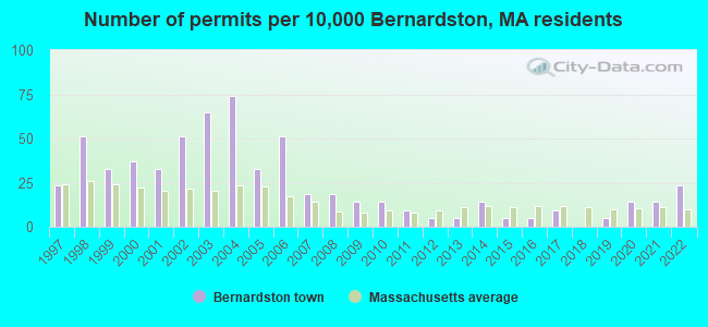
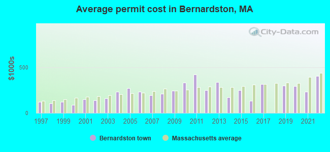
Single-family new house construction building permits:
- 2022: 5 buildings, average cost: $406,000
- 2021: 3 buildings, average cost: $233,300
- 2020: 3 buildings, average cost: $292,000
- 2019: 1 building, cost: $300,000
- 2017: 2 buildings, average cost: $312,500
- 2016: 1 building, cost: $132,500
- 2015: 1 building, cost: $250,000
- 2014: 3 buildings, average cost: $168,800
- 2013: 1 building, cost: $335,000
- 2012: 1 building, cost: $250,000
- 2011: 2 buildings, average cost: $420,400
- 2010: 3 buildings, average cost: $330,600
- 2009: 3 buildings, average cost: $240,700
- 2008: 4 buildings, average cost: $209,800
- 2007: 4 buildings, average cost: $196,000
- 2006: 11 buildings, average cost: $234,100
- 2005: 7 buildings, average cost: $268,700
- 2004: 16 buildings, average cost: $232,000
- 2003: 14 buildings, average cost: $159,400
- 2002: 11 buildings, average cost: $137,000
- 2001: 7 buildings, average cost: $148,500
- 2000: 8 buildings, average cost: $89,300
- 1999: 7 buildings, average cost: $121,300
- 1998: 11 buildings, average cost: $103,600
- 1997: 5 buildings, average cost: $120,600
| Here: | 3.7% |
| Massachusetts: | 3.5% |
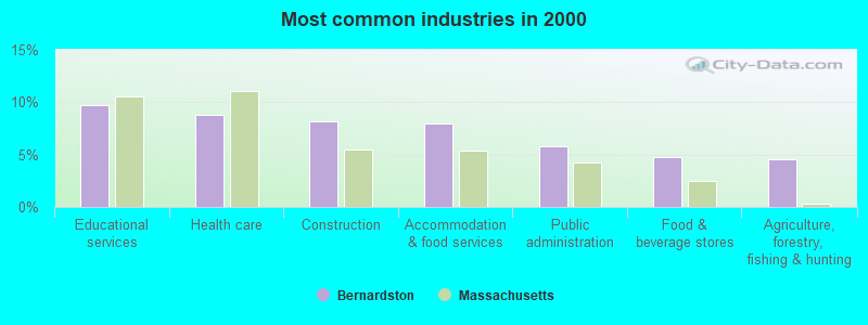
- Educational services (9.7%)
- Health care (8.8%)
- Construction (8.2%)
- Accommodation & food services (7.9%)
- Public administration (5.8%)
- Food & beverage stores (4.8%)
- Agriculture, forestry, fishing & hunting (4.5%)
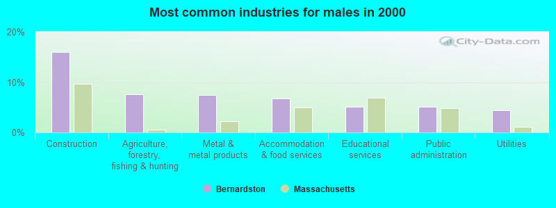
- Construction (16.0%)
- Agriculture, forestry, fishing & hunting (7.6%)
- Metal & metal products (7.4%)
- Accommodation & food services (6.7%)
- Educational services (5.1%)
- Public administration (5.1%)
- Utilities (4.4%)
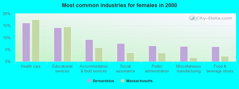
- Health care (16.2%)
- Educational services (14.1%)
- Accommodation & food services (9.1%)
- Social assistance (7.6%)
- Public administration (6.6%)
- Miscellaneous manufacturing (6.4%)
- Food & beverage stores (6.2%)
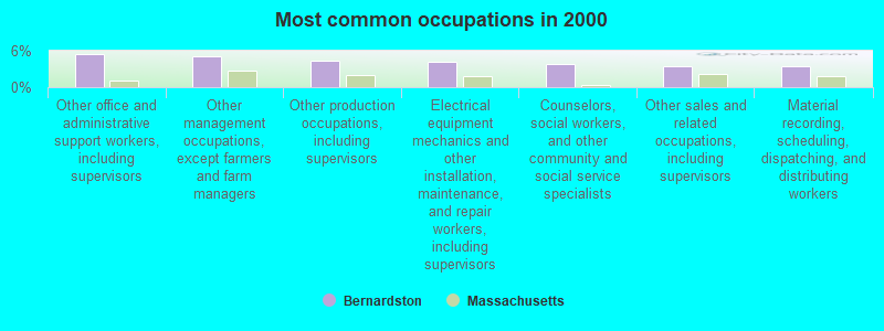
- Other office and administrative support workers, including supervisors (5.5%)
- Other management occupations, except farmers and farm managers (5.1%)
- Other production occupations, including supervisors (4.4%)
- Electrical equipment mechanics and other installation, maintenance, and repair workers, including supervisors (4.2%)
- Counselors, social workers, and other community and social service specialists (3.7%)
- Other sales and related occupations, including supervisors (3.5%)
- Material recording, scheduling, dispatching, and distributing workers (3.4%)
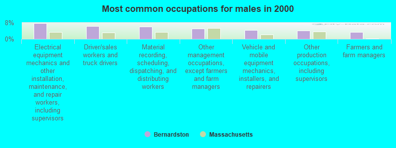
- Electrical equipment mechanics and other installation, maintenance, and repair workers, including supervisors (7.8%)
- Driver/sales workers and truck drivers (6.3%)
- Material recording, scheduling, dispatching, and distributing workers (6.2%)
- Other management occupations, except farmers and farm managers (5.1%)
- Vehicle and mobile equipment mechanics, installers, and repairers (4.4%)
- Other production occupations, including supervisors (4.1%)
- Farmers and farm managers (3.4%)

- Other office and administrative support workers, including supervisors (8.4%)
- Health technologists and technicians (6.4%)
- Counselors, social workers, and other community and social service specialists (6.0%)
- Other management occupations, except farmers and farm managers (5.0%)
- Secretaries and administrative assistants (5.0%)
- Preschool, kindergarten, elementary, and middle school teachers (4.7%)
- Other production occupations, including supervisors (4.7%)
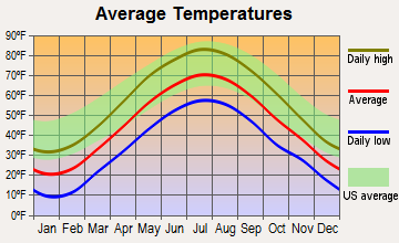
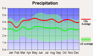
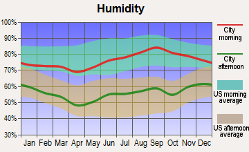
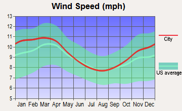
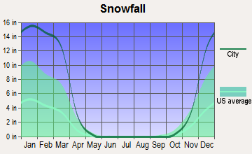
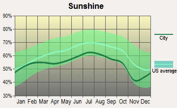
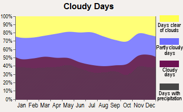
Average climate in Bernardston, Massachusetts
Based on data reported by over 4,000 weather stations
(lower is better)
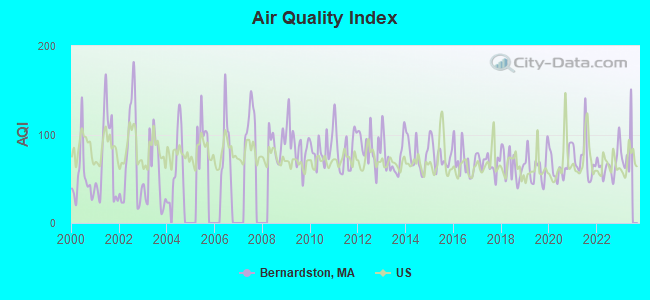
Air Quality Index (AQI) level in 2022 was 65.9. This is about average.
| City: | 65.9 |
| U.S.: | 72.6 |
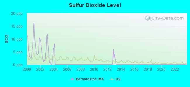
Sulfur Dioxide (SO2) [ppb] level in 2003 was 3.66. This is significantly worse than average. Closest monitor was 7.3 miles away from the city center.
| City: | 3.66 |
| U.S.: | 1.51 |
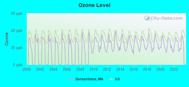
Ozone [ppb] level in 2022 was 23.8. This is better than average. Closest monitor was 5.5 miles away from the city center.
| City: | 23.8 |
| U.S.: | 33.3 |
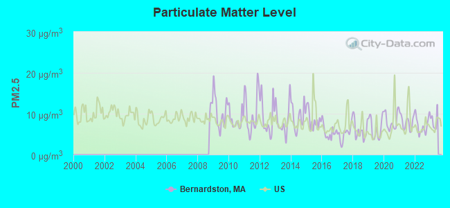
Particulate Matter (PM2.5) [µg/m3] level in 2022 was 7.21. This is about average. Closest monitor was 5.5 miles away from the city center.
| City: | 7.21 |
| U.S.: | 8.11 |
Tornado activity:
Bernardston-area historical tornado activity is slightly above Massachusetts state average. It is 16% smaller than the overall U.S. average.
On 6/9/1953, a category F4 (max. wind speeds 207-260 mph) tornado 24.0 miles away from the Bernardston town center killed 90 people and injured 1228 people and caused between $50,000,000 and $500,000,000 in damages.
On 10/3/1979, a category F4 tornado 44.1 miles away from the town center killed 3 people and injured 500 people and caused between $50,000,000 and $500,000,000 in damages.
Earthquake activity:
Bernardston-area historical earthquake activity is significantly above Massachusetts state average. It is 70% smaller than the overall U.S. average.On 10/7/1983 at 10:18:46, a magnitude 5.3 (5.1 MB, 5.3 LG, 5.1 ML, Class: Moderate, Intensity: VI - VII) earthquake occurred 126.3 miles away from Bernardston center
On 4/20/2002 at 10:50:47, a magnitude 5.3 (5.3 ML, Depth: 3.0 mi) earthquake occurred 139.4 miles away from Bernardston center
On 4/20/2002 at 10:50:47, a magnitude 5.2 (5.2 MB, 4.2 MS, 5.2 MW, 5.0 MW) earthquake occurred 138.2 miles away from the city center
On 1/19/1982 at 00:14:42, a magnitude 4.7 (4.5 MB, 4.7 MD, 4.5 LG, Class: Light, Intensity: IV - V) earthquake occurred 74.4 miles away from Bernardston center
On 10/16/2012 at 23:12:25, a magnitude 4.7 (4.7 ML, Depth: 10.0 mi) earthquake occurred 114.7 miles away from the city center
On 6/17/1991 at 08:53:16, a magnitude 4.1 (4.0 MB, 4.0 LG, Depth: 3.1 mi) earthquake occurred 108.4 miles away from the city center
Magnitude types: regional Lg-wave magnitude (LG), body-wave magnitude (MB), duration magnitude (MD), local magnitude (ML), surface-wave magnitude (MS), moment magnitude (MW)
Natural disasters:
The number of natural disasters in Franklin County (20) is greater than the US average (15).Major Disasters (Presidential) Declared: 9
Emergencies Declared: 10
Causes of natural disasters: Floods: 5, Storms: 5, Hurricanes: 4, Snowstorms: 4, Winter Storms: 3, Blizzards: 2, Snows: 2, Snowfall: 1, Tropical Storm: 1, Wind: 1, Other: 1 (Note: some incidents may be assigned to more than one category).
Hospitals and medical centers near Bernardston:
- NURSE'S HOUSE CALL - GREENFIELD (Home Health Center, about 6 miles away; GREENFIELD, MA)
- YANKEE FAMILY DIALYSIS CENTER (Dialysis Facility, about 6 miles away; GREENFIELD, MA)
- POET'S SEAT HEALTH CARE CENTER (Nursing Home, about 6 miles away; GREENFIELD, MA)
- HOSPICE OF FRANKLIN COUNTY, INC (Hospital, about 7 miles away; GREENFIELD, MA)
- FRANKLIN CENTER (Nursing Home, about 7 miles away; GREENFIELD, MA)
- BAYSTATE FRANKLIN MEDICAL CENTER Acute Care Hospitals (about 7 miles away; GREENFIELD, MA)
- HOSPICE OF FRANKLIN COUNTY (Hospital, about 7 miles away; GREENFIELD, MA)
Operable nuclear power plant near Bernardston:
- 7 miles: Vermont Yankee in Vernon, VT.
Colleges/universities with over 2000 students nearest to Bernardston:
- University of Massachusetts-Amherst (about 21 miles; Amherst, MA; Full-time enrollment: 26,583)
- Keene State College (about 22 miles; Keene, NH; FT enrollment: 5,098)
- Smith College (about 26 miles; Northampton, MA; FT enrollment: 3,549)
- Franklin Pierce University (about 26 miles; Rindge, NH; FT enrollment: 2,139)
- Mount Holyoke College (about 30 miles; South Hadley, MA; FT enrollment: 2,573)
- Mount Wachusett Community College (about 30 miles; Gardner, MA; FT enrollment: 3,143)
- Williams College (about 34 miles; Williamstown, MA; FT enrollment: 2,141)
Public elementary/middle school in Bernardston:
- BERNARDSTON ELEMENTARY (Students: 186, Location: 37 SCHOOL ROAD, Grades: PK-6)
Private elementary/middle school in Bernardston:
Points of interest:
Notable locations in Bernardston: Crumpin-Fox Club Golf Course (A), Bernardston Fire Department (B). Display/hide their locations on the map
Church in Bernardston: United Church of Bernardston (A). Display/hide its location on the map
Cemetery: Old Cemetery (1). Display/hide its location on the map
Lakes and reservoirs: Deane Pond (A), Fall River Reservoir (B). Display/hide their locations on the map
Streams, rivers, and creeks: West Brook (A), Couch Brook (B), Shattuck Brook (C), Shatluck Brook (D). Display/hide their locations on the map
Parks in Bernardston include: Satans Kingdom Wildlife Management Area (1), Cushman Park (2). Display/hide their locations on the map
Birthplace of: Adam Harrington (basketball) - Basketball player, Joseph Denison - Methodist cleric, Marshall Chapin - Physician, Bryant Butler Brooks - Politician.
Drinking water stations with addresses in Bernardston and their reported violations in the past:
BERNARDSTON FIRE WATER DIST (Population served: 1,552, Groundwater):Past health violations:Past monitoring violations:
- MCL, Monthly (TCR) - In AUG-2013, Contaminant: Coliform. Follow-up actions: St AO (w/o penalty) issued (SEP-13-2013)
- MCL, Monthly (TCR) - In JUN-2013, Contaminant: Coliform. Follow-up actions: St AO (w/o penalty) issued (AUG-13-2013)
- MCL, Monthly (TCR) - In OCT-2012, Contaminant: Coliform. Follow-up actions: St AO (w/o penalty) issued (NOV-09-2012)
- MCL, Monthly (TCR) - In OCT-2010, Contaminant: Coliform. Follow-up actions: St AO (w/o penalty) issued (2 times from NOV-24-2010 to AUG-13-2013)
- MCL, Monthly (TCR) - In AUG-2009, Contaminant: Coliform. Follow-up actions: St AO (w/o penalty) issued (OCT-21-2009)
- MCL, Acute (TCR) - In SEP-2008, Contaminant: Coliform. Follow-up actions: St AO (w/o penalty) issued (OCT-21-2009)
- Monitoring, Repeat Major (TCR) - In SEP-2013, Contaminant: Coliform (TCR)
- Follow-up Or Routine LCR Tap M/R - In JAN-01-2011, Contaminant: Lead and Copper Rule. Follow-up actions: St AO (w/o penalty) issued (FEB-24-2014)
- One regular monitoring violation
| This town: | 2.4 people |
| Massachusetts: | 2.5 people |
| This town: | 68.4% |
| Whole state: | 63.0% |
| This town: | 9.0% |
| Whole state: | 7.0% |
Likely homosexual households (counted as self-reported same-sex unmarried-partner households)
- Lesbian couples: 0.6% of all households
- Gay men: 0.4% of all households
| This town: | 4.4% |
| Whole state: | 9.3% |
| This town: | 1.5% |
| Whole state: | 4.4% |
People in group quarters in Bernardston in 2000:
- 11 people in homes or halfway houses for drug/alcohol abuse
- 6 people in other group homes
- 4 people in nursing homes
For population 15 years and over in Bernardston:
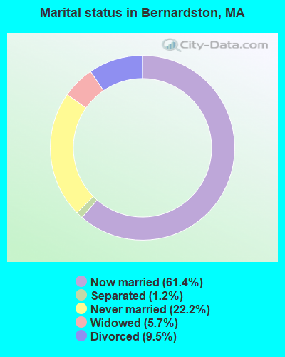
- Never married: 22.2%
- Now married: 61.4%
- Separated: 1.2%
- Widowed: 5.7%
- Divorced: 9.5%
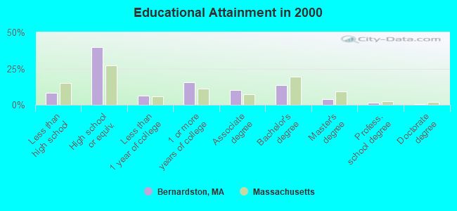
For population 25 years and over in Bernardston:
- High school or higher: 91.9%
- Bachelor's degree or higher: 19.5%
- Graduate or professional degree: 6.0%
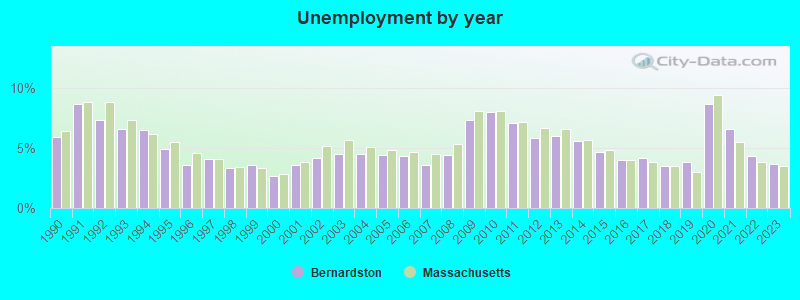
- Unemployed: 3.9%
- Mean travel time to work (commute): 19.7 minutes
| Here: | 8.7 |
| Massachusetts average: | 13.1 |


Graphs represent county-level data. Detailed 2008 Election Results
Religion statistics for Bernardston, MA (based on Franklin County data)


| Religion | Adherents | Congregations |
|---|---|---|
| Catholic | 16,509 | 15 |
| Mainline Protestant | 4,617 | 38 |
| Evangelical Protestant | 2,079 | 20 |
| Other | 1,580 | 21 |
| None | 46,587 | - |
Food Environment Statistics:
| This county: | 3.63 / 10,000 pop. |
| Massachusetts: | 1.98 / 10,000 pop. |
| Here: | 0.14 / 10,000 pop. |
| State: | 0.05 / 10,000 pop. |
| Here: | 1.67 / 10,000 pop. |
| Massachusetts: | 2.22 / 10,000 pop. |
| This county: | 3.21 / 10,000 pop. |
| State: | 1.77 / 10,000 pop. |
| Franklin County: | 8.10 / 10,000 pop. |
| Massachusetts: | 8.76 / 10,000 pop. |
| This county: | 7.5% |
| Massachusetts: | 8.1% |
| Franklin County: | 22.2% |
| Massachusetts: | 22.5% |
| This county: | 15.1% |
| State: | 16.5% |
Strongest AM radio stations in Bernardston:
- WIZZ (1520 AM; daytime; 10 kW; GREENFIELD, MA; Owner: P. & M. RADIO, LLC)
- WNNZ (640 AM; 50 kW; WESTFIELD, MA; Owner: CLEAR CHANNEL BROADCASTING LICENSES, INC.)
- WCRN (830 AM; 50 kW; WORCESTER, MA; Owner: CARTER BROADCASTING CORPORATION)
- WVNE (760 AM; daytime; 25 kW; LEICESTER, MA; Owner: BLOUNT MASSCOM, INC.)
- WHMQ (1240 AM; 1 kW; GREENFIELD, MA; Owner: SAGA COMMUNICATIONS OF NEW ENGLAND, LLC)
- WCAT (700 AM; daytime; 2 kW; ORANGE-ATHOL, MA; Owner: CITADEL BROADCASTING COMPANY)
- WRKO (680 AM; 50 kW; BOSTON, MA; Owner: ENTERCOM BOSTON LICENSE, LLC)
- WTIC (1080 AM; 50 kW; HARTFORD, CT; Owner: INFINITY RADIO OPERATIONS INC.)
- WEEI (850 AM; 50 kW; BOSTON, MA; Owner: ENTERCOM BOSTON LICENSE, LLC)
- WGY (810 AM; 50 kW; SCHENECTADY, NY; Owner: CLEAR CHANNEL BROADCASTING LICENSES, INC.)
- WKOX (1200 AM; 50 kW; FRAMINGHAM, MA; Owner: CAPSTAR TX LIMITED PARTNERSHIP)
- WALE (990 AM; 50 kW; GREENVILLE, RI; Owner: NORTH AMERICAN BROADCASTING CO., INC.)
- WBIX (1060 AM; 40 kW; NATICK, MA; Owner: LANGER BROADCASTING CORPORATION)
Strongest FM radio stations in Bernardston:
- WPVQ (95.3 FM; GREENFIELD, MA; Owner: GREAT NORTHERN RADIO, L.L.C.)
- WYRY (104.9 FM; HINSDALE, NH; Owner: TRI-VALLEY BROADCASTING CORPORATION)
- WHAI (98.3 FM; GREENFIELD, MA; Owner: SAGA COMMUNICATIONS OF NEW ENGLAND, LLC)
- WRSY (101.5 FM; MARLBORO, VT; Owner: GREAT NORTHERN RADIO, L.L.C.)
- WRSI (93.9 FM; TURNERS FALLS, MA; Owner: GREAT NORTHERN RADIO, LLC)
- WAMC-FM (90.3 FM; ALBANY, NY; Owner: WAMC)
- WOQL (98.7 FM; WINCHESTER, NH; Owner: SAGA COMMUNICATIONS OF NEW HAMPSHIRE, LLC)
- WVAY (100.7 FM; WILMINGTON, VT; Owner: GREAT NORTHERN RADIO, L.L.C.)
- WEQX (102.7 FM; MANCHESTER, VT; Owner: NORTHSHIRE COMMUNICATIONS, INC.)
- WJDF (97.3 FM; ORANGE, MA; Owner: DEANE BROTHERS BROADCASTING CORP.)
- WJAN (95.1 FM; SUNDERLAND, VT; Owner: 6 JOHNSON ROAD LICENSES, INC.)
- WFCR (88.5 FM; AMHERST, MA; Owner: UNIVERSITY OF MASSACHUSETTS)
- WKVT-FM (92.7 FM; BRATTLEBORO, VT; Owner: SAGA COMMUNICATIONS OF NEW ENGLAND, LLC)
- WGAJ (91.7 FM; DEERFIELD, MA; Owner: TRUATEES OF DEERFIELD ACADEMY)
- WCMK (91.9 FM; PUTNEY, VT; Owner: CHRISTIAN MINISTRIES INC)
- WKNE (103.7 FM; KEENE, NH; Owner: SAGA COMMUNICATIONS OF NEW ENGLAND, LLC)
- WEVN (90.7 FM; KEENE, NH; Owner: NEW HAMPSHIRE PUBLIC RADIO, INC.)
- WHDQ (106.1 FM; CLAREMONT, NH; Owner: GREAT NORTHERN RADIO, L.L.C.)
- WFEX (92.1 FM; PETERBOROUGH, NH; Owner: FNX BROADCASTING OF NEW HAMPSHIRE LLC)
- WAMH (89.3 FM; AMHERST, MA; Owner: TRUSTEES OF AMHERST COLLEGE)
TV broadcast stations around Bernardston:
- WYDN (Channel 48; WORCESTER, MA; Owner: EDUCATIONAL PUBLIC TV CORPORATION)
- WUNI (Channel 27; WORCESTER, MA; Owner: ENTRAVISION HOLDINGS, LLC)
- WEKW-TV (Channel 52; KEENE, NH; Owner: UNIVERSITY OF NEW HAMPSHIRE)
- W35BK (Channel 35; PLAINFIELD, MA; Owner: LYDIA SYLVANE STOCKWELL)
- National Bridge Inventory (NBI) Statistics
- 13Number of bridges
- 190ft / 58.3mTotal length
- $44,362,000Total costs
- 77,685Total average daily traffic
- 7,435Total average daily truck traffic
- 142,574Total future (year 2031) average daily traffic
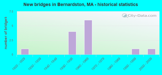
- New bridges - historical statistics
- 11920-1929
- 41950-1959
- 61960-1969
- 11990-1999
- 12000-2009
FCC Registered Broadcast Land Mobile Towers:
5- 170 Huckle Hill Rd (Lat: 42.506194 Lon: -72.528139), Call Sign: KOH621, Licensee ID: L00043653,
Assigned Frequencies: 151.805 MHz, Grant Date: 09/20/2002, Expiration Date: 11/09/2012, Cancellation Date: 01/12/2013, Registrant: Valley Masonry & Construction Co, 11 Deacon Parker Rd, Bernardston, MA 01337, Phone: (413) 648-9182
- Rt 10 100 E Int Of Gill Rd & Parmenter Rd (Lat: 42.669250 Lon: -72.502306), Call Sign: KWN511,
Assigned Frequencies: 152.915 MHz, Grant Date: 10/21/2004, Expiration Date: 01/11/2015, Cancellation Date: 07/02/2009, Registrant: Federal Licensing Inc, 1588 Fairfield Road, Gettysburg, PA 17325, Phone: (717) 334-9262, Fax: (717) 334-6440
- Lat: 42.655833 Lon: -72.560000, Call Sign: WQNB723,
Assigned Frequencies: 452.112 MHz, 457.112 MHz, 452.712 MHz, 457.712 MHz, 452.187 MHz, Grant Date: 12/07/2010, Expiration Date: 12/07/2020, Cancellation Date: 02/06/2021, Certifier: Marc Bernier, Registrant: Wpcs International Hartford Operations, 427 Hayden Station Road, Stes. A&b, Windsor, CT 06095, Phone: (860) 972-3699, Fax: (860) 640-6599, Email:
- Lat: 42.683500 Lon: -72.485722, Call Sign: WQTL480,
Assigned Frequencies: 467.212 MHz, Grant Date: 02/27/2014, Expiration Date: 02/27/2024, Certifier: Tina Mahaney, Registrant: Innovation Wireless, 11869 Teale Street, Culver City, CA 90230, Phone: (888) 559-5565, Fax: (310) 482-3480, Email:
- 87 Parmeter Rd (Lat: 42.680000 Lon: -72.522833), Call Sign: WQXS917,
Assigned Frequencies: 159.570 MHz, 159.840 MHz, 160.095 MHz, Grant Date: 05/31/2016, Expiration Date: 05/31/2026, Certifier: Scott Gilmore, Registrant: Lone Peak Licensing, LLC, Draper, UT 84020-1336, Phone: (801) 938-9346, Fax: (801) 938-9465, Email:
FCC Registered Microwave Towers:
2- CT13XC248, 250 Brattleboro Rd (Lat: 42.686750 Lon: -72.551861), Type: Pole, Structure height: 54.9 m, Overall height: 56.1 m, Call Sign: WQPU580,
Assigned Frequencies: 10775.0 MHz, 10895.0 MHz, 10935.0 MHz, 10775.0 MHz, 10895.0 MHz, 10935.0 MHz, 10775.0 MHz, 10895.0 MHz, 10935.0 MHz, Grant Date: 08/17/2012, Expiration Date: 08/17/2022, Cancellation Date: 08/10/2022, Certifier: David Werblow, Registrant: Dla Piper LLP, 500 8th Street, Nw, Washington, DC 20004, Phone: (202) 799-4216, Fax: (202) 799-5616, Email:
- STATION, M D P W Maintenance Depot I91 (Lat: 42.670083 Lon: -72.541750), Overall height: 24.4 m, Call Sign: WBH351,
Assigned Frequencies: 956.800 MHz, Grant Date: 09/22/2020, Expiration Date: 11/21/2030, Registrant: Massachusetts Department Of Transportation- Highway, 10 Park Plaza - Suite 7410, Boston, MA 02116, Phone: (617) 835-6922, Email:
FCC Registered Amateur Radio Licenses:
14 (See the full list of FCC Registered Amateur Radio Licenses in Bernardston)FAA Registered Aircraft:
1- Aircraft: S C AEROSTAR S A YAK-52 (Category: Land, Seats: 2, Weight: Up to 12,499 Pounds), Engine: AMA/EXPR UNKNOWN ENG (Reciprocating)
N-Number: 9900X, N9900X, N-9900X, Serial Number: 888509, Year manufactured: 1988, Airworthiness Date: 01/22/2003, Certificate Issue Date: 12/09/2003
Registrant (Individual): Steve A Johnson, 184 West Rd, Bernardston, MA 01337
2002 - 2018 National Fire Incident Reporting System (NFIRS) incidents
- Fire incident types reported to NFIRS in Bernardston, MA
- 11839.6%Outside Fires
- 11137.2%Structure Fires
- 4314.4%Mobile Property/Vehicle Fires
- 268.7%Other
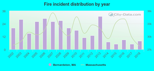 According to the data from the years 2002 - 2018 the average number of fires per year is 18. The highest number of fire incidents - 31 took place in 2013, and the least - 5 in 2015. The data has a declining trend.
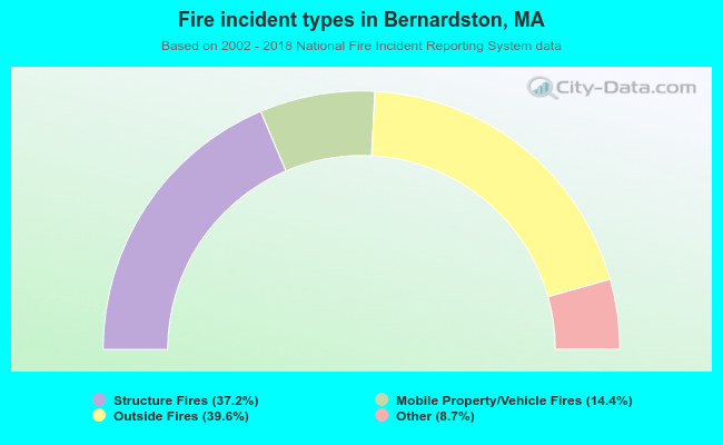 When looking into fire subcategories, the most incidents belonged to: Outside Fires (39.6%), and Structure Fires (37.2%).
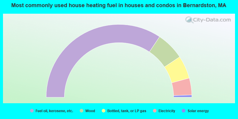
- 68.8%Fuel oil, kerosene, etc.
- 12.5%Wood
- 10.2%Bottled, tank, or LP gas
- 7.5%Electricity
- 1.0%Solar energy
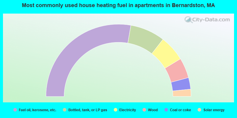
- 55.5%Fuel oil, kerosene, etc.
- 15.5%Bottled, tank, or LP gas
- 11.6%Electricity
- 9.0%Wood
- 5.2%Coal or coke
- 3.2%Solar energy
Bernardston compared to Massachusetts state average:
- Median house value below state average.
- Unemployed percentage significantly below state average.
- Black race population percentage significantly below state average.
- Hispanic race population percentage significantly below state average.
- Median age significantly above state average.
- Foreign-born population percentage significantly below state average.
- Renting percentage significantly below state average.
- Length of stay since moving in significantly above state average.
- Number of rooms per house significantly below state average.
- House age significantly below state average.
- Percentage of population with a bachelor's degree or higher below state average.

|
Total of 1 patent application in 2008-2024.