Bethlehem, Connecticut
Submit your own pictures of this town and show them to the world
- OSM Map
- General Map
- Google Map
- MSN Map
Population change since 2000: +5.4%
 |
| Males: 1,779 | |
| Females: 1,828 |
| Median resident age: | 47.1 years |
| Connecticut median age: | 39.2 years |
Zip codes: 06751.
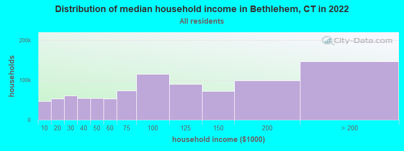
| Bethlehem: | $112,378 |
| CT: | $88,429 |
Estimated per capita income in 2022: $53,206 (it was $29,672 in 2000)
Bethlehem town income, earnings, and wages data
Estimated median house or condo value in 2022: $476,049 (it was $220,200 in 2000)
| Bethlehem: | $476,049 |
| CT: | $347,200 |
Mean prices in 2022: all housing units: $429,743; detached houses: $455,293; townhouses or other attached units: $232,674; in 2-unit structures: $242,050; in 3-to-4-unit structures: $229,634; in 5-or-more-unit structures: $182,162; mobile homes: $243,504; occupied boats, rvs, vans, etc.: $127,144
Detailed information about poverty and poor residents in Bethlehem, CT


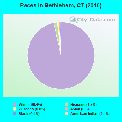
- 3,47796.4%White alone
- 611.7%Hispanic
- 280.8%Two or more races
- 180.5%Asian alone
- 160.4%Black alone
- 40.1%American Indian alone
- 30.08%Other race alone
Races in Bethlehem detailed stats: ancestries, foreign born residents, place of birth
 Recent articles from our blog. Our writers, many of them Ph.D. graduates or candidates, create easy-to-read articles on a wide variety of topics.

 | 2024 Connecticut Town Tournament VI (Celebrating the 10-Year Anniversary & Dazzleman's Memorial) (1154 replies) |
| Considering Bethlehem, CT from CA, culture shock? (15 replies) |
| Connecticut TOWN TOURNAMENT V (2022) (831 replies) |
| Connecticut Weather Discussion 3 (8061 replies) |
| Current Real estate markets (3987 replies) |
| Connecticut TOWN TOURNAMENT IV (2020) (849 replies) |
Latest news from Bethlehem, CT collected exclusively by city-data.com from local newspapers, TV, and radio stations
Bethlehem, CT City Guides:
Ancestries: Italian (21.2%), Irish (20.0%), German (14.9%), English (12.7%), Lithuanian (8.2%), Polish (8.2%).
Current Local Time: EST time zone
Incorporated on 05/1787
Elevation: 861 feet
Land area: 19.4 square miles.
Population density: 186 people per square mile (very low).
120 residents are foreign born (2.5% Europe, 0.8% Latin America).
| This town: | 3.5% |
| Connecticut: | 10.9% |
| Bethlehem town: | 1.4% ($3,004) |
| Connecticut: | 1.8% ($2,961) |
Nearest city with pop. 50,000+: Waterbury, CT  (10.3 miles , pop. 107,271).
Nearest city with pop. 200,000+: North Hempstead, NY (63.7 miles , pop. 222,611).
Nearest city with pop. 1,000,000+: Bronx, NY (64.3 miles , pop. 1,332,650).
Nearest cities:
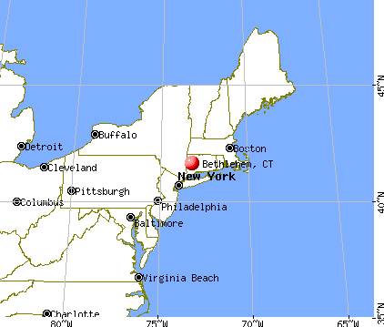
), ), ), ), )Latitude: 41.63 N, Longitude: 73.21 W

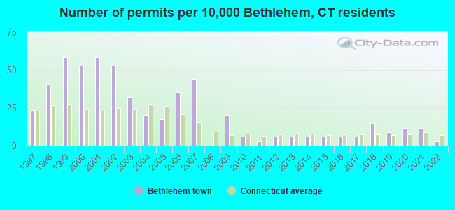
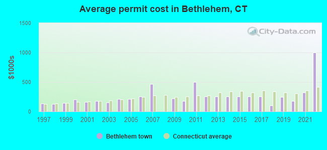
Single-family new house construction building permits:
- 2022: 1 building, cost: $1,000,000
- 2021: 4 buildings, average cost: $319,800
- 2020: 4 buildings, average cost: $176,500
- 2019: 3 buildings, average cost: $245,700
- 2018: 5 buildings, average cost: $102,000
- 2017: 2 buildings, average cost: $252,500
- 2016: 2 buildings, average cost: $252,500
- 2015: 2 buildings, average cost: $252,500
- 2014: 2 buildings, average cost: $252,500
- 2013: 2 buildings, average cost: $252,500
- 2012: 2 buildings, average cost: $252,500
- 2011: 1 building, cost: $500,000
- 2010: 2 buildings, average cost: $176,500
- 2009: 7 buildings, average cost: $218,100
- 2007: 15 buildings, average cost: $466,700
- 2006: 12 buildings, average cost: $252,000
- 2005: 6 buildings, average cost: $209,700
- 2004: 7 buildings, average cost: $209,700
- 2003: 11 buildings, average cost: $148,900
- 2002: 18 buildings, average cost: $174,200
- 2001: 20 buildings, average cost: $165,300
- 2000: 18 buildings, average cost: $203,100
- 1999: 20 buildings, average cost: $141,900
- 1998: 14 buildings, average cost: $125,400
- 1997: 8 buildings, average cost: $131,600
| Here: | 3.1% |
| Connecticut: | 3.9% |
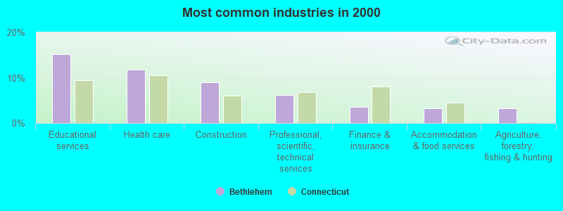
- Educational services (15.2%)
- Health care (11.8%)
- Construction (9.0%)
- Professional, scientific, technical services (6.3%)
- Finance & insurance (3.6%)
- Accommodation & food services (3.3%)
- Agriculture, forestry, fishing & hunting (3.2%)
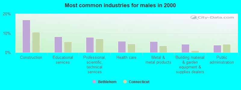
- Construction (16.9%)
- Educational services (8.2%)
- Professional, scientific, technical services (7.8%)
- Health care (6.0%)
- Metal & metal products (5.7%)
- Building material & garden equipment & supplies dealers (4.4%)
- Public administration (3.9%)
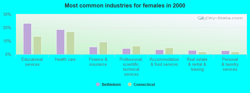
- Educational services (23.2%)
- Health care (18.5%)
- Finance & insurance (5.7%)
- Professional, scientific, technical services (4.4%)
- Accommodation & food services (3.5%)
- Real estate & rental & leasing (3.0%)
- Personal & laundry services (2.8%)
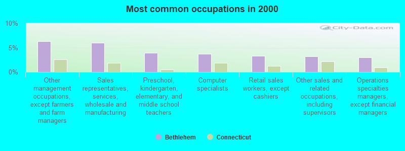
- Other management occupations, except farmers and farm managers (6.3%)
- Sales representatives, services, wholesale and manufacturing (6.0%)
- Preschool, kindergarten, elementary, and middle school teachers (3.9%)
- Computer specialists (3.7%)
- Retail sales workers, except cashiers (3.3%)
- Other sales and related occupations, including supervisors (3.2%)
- Operations specialties managers, except financial managers (3.0%)
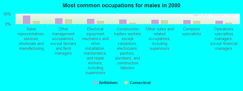
- Sales representatives, services, wholesale and manufacturing (8.9%)
- Other management occupations, except farmers and farm managers (6.1%)
- Electrical equipment mechanics and other installation, maintenance, and repair workers, including supervisors (5.6%)
- Construction traders workers except carpenters, electricians, painters, plumbers, and construction laborers (4.8%)
- Other sales and related occupations, including supervisors (4.6%)
- Computer specialists (4.2%)
- Operations specialties managers, except financial managers (3.7%)
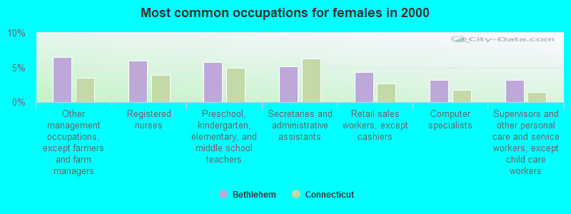
- Other management occupations, except farmers and farm managers (6.5%)
- Registered nurses (6.0%)
- Preschool, kindergarten, elementary, and middle school teachers (5.8%)
- Secretaries and administrative assistants (5.1%)
- Retail sales workers, except cashiers (4.3%)
- Computer specialists (3.2%)
- Supervisors and other personal care and service workers, except child care workers (3.2%)
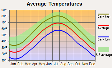
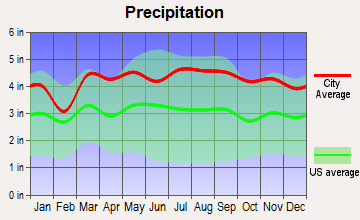
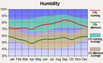
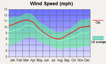
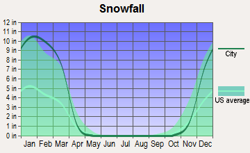
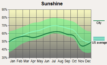
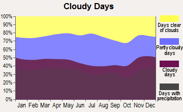
Average climate in Bethlehem, Connecticut
Based on data reported by over 4,000 weather stations
(lower is better)
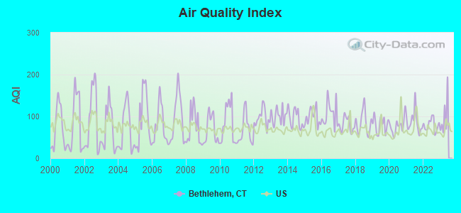
Air Quality Index (AQI) level in 2022 was 79.2. This is about average.
| City: | 79.2 |
| U.S.: | 72.6 |
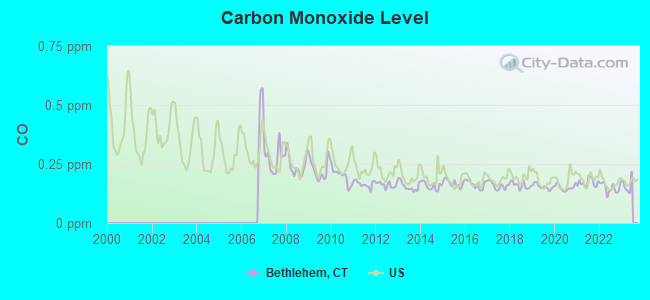
Carbon Monoxide (CO) [ppm] level in 2022 was 0.149. This is significantly better than average. Closest monitor was 6.8 miles away from the city center.
| City: | 0.149 |
| U.S.: | 0.251 |
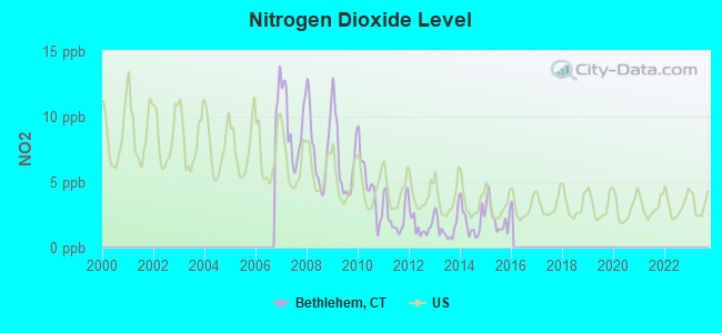
Nitrogen Dioxide (NO2) [ppb] level in 2015 was 2.27. This is significantly better than average. Closest monitor was 4.5 miles away from the city center.
| City: | 2.27 |
| U.S.: | 5.11 |
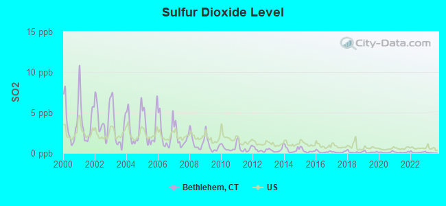
Sulfur Dioxide (SO2) [ppb] level in 2022 was 0.109. This is significantly better than average. Closest monitor was 4.5 miles away from the city center.
| City: | 0.109 |
| U.S.: | 1.515 |
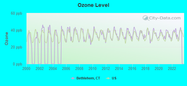
Ozone [ppb] level in 2022 was 36.2. This is about average. Closest monitor was 4.5 miles away from the city center.
| City: | 36.2 |
| U.S.: | 33.3 |
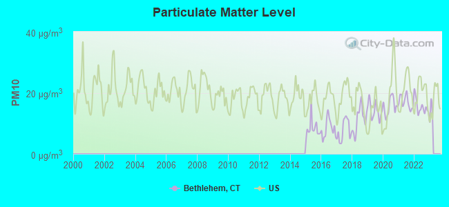
Particulate Matter (PM10) [µg/m3] level in 2022 was 15.4. This is better than average. Closest monitor was 10.3 miles away from the city center.
| City: | 15.4 |
| U.S.: | 19.2 |
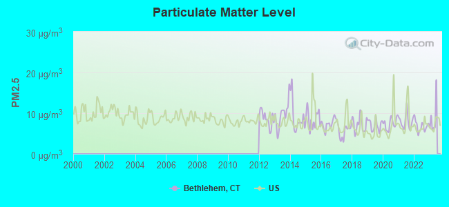
Particulate Matter (PM2.5) [µg/m3] level in 2022 was 6.82. This is about average. Closest monitor was 6.8 miles away from the city center.
| City: | 6.82 |
| U.S.: | 8.11 |
Tornado activity:
Bethlehem-area historical tornado activity is slightly above Connecticut state average. It is 22% smaller than the overall U.S. average.
On 7/10/1989, a category F4 (max. wind speeds 207-260 mph) tornado 23.7 miles away from the Bethlehem town center injured 40 people and caused between $50,000,000 and $500,000,000 in damages.
On 5/24/1962, a category F3 (max. wind speeds 158-206 mph) tornado 7.4 miles away from the town center killed one person and injured 50 people and caused between $500,000 and $5,000,000 in damages.
Earthquake activity:
Bethlehem-area historical earthquake activity is significantly above Connecticut state average. It is 69% smaller than the overall U.S. average.On 10/7/1983 at 10:18:46, a magnitude 5.3 (5.1 MB, 5.3 LG, 5.1 ML, Class: Moderate, Intensity: VI - VII) earthquake occurred 170.5 miles away from the city center
On 4/20/2002 at 10:50:47, a magnitude 5.3 (5.3 ML, Depth: 3.0 mi) earthquake occurred 200.7 miles away from Bethlehem center
On 4/20/2002 at 10:50:47, a magnitude 5.2 (5.2 MB, 4.2 MS, 5.2 MW, 5.0 MW) earthquake occurred 199.1 miles away from the city center
On 8/23/2011 at 17:51:04, a magnitude 5.8 (5.8 MW, Depth: 3.7 mi) earthquake occurred 359.6 miles away from the city center
On 1/19/1982 at 00:14:42, a magnitude 4.7 (4.5 MB, 4.7 MD, 4.5 LG, Class: Light, Intensity: IV - V) earthquake occurred 153.0 miles away from Bethlehem center
On 10/16/2012 at 23:12:25, a magnitude 4.7 (4.7 ML, Depth: 10.0 mi) earthquake occurred 188.1 miles away from the city center
Magnitude types: regional Lg-wave magnitude (LG), body-wave magnitude (MB), duration magnitude (MD), local magnitude (ML), surface-wave magnitude (MS), moment magnitude (MW)
Natural disasters:
The number of natural disasters in Litchfield County (23) is greater than the US average (15).Major Disasters (Presidential) Declared: 13
Emergencies Declared: 10
Causes of natural disasters: Storms: 7, Hurricanes: 5, Floods: 4, Snowstorms: 4, Blizzards: 3, Snows: 2, Tropical Storms: 2, Winter Storms: 2, Snowfall: 1, Tornado: 1, Wind: 1 (Note: some incidents may be assigned to more than one category).
Hospitals and medical centers near Bethlehem:
- WATERTOWN CONVALARIUM, INC (Nursing Home, about 5 miles away; WATERTOWN, CT)
- C I B: WATERTOWN COM. RES. (Hospital, about 6 miles away; WATERTOWN, CT)
- HOSPICE PROFJECT CARE INC (Hospital, about 6 miles away; WATERTOWN, CT)
- APPLE REHAB WATERTOWN (Nursing Home, about 7 miles away; WATERTOWN, CT)
- PARADIGM HEALTHCARE CENTER OF WATERBURY, LLC (Nursing Home, about 8 miles away; WATERBURY, CT)
- MIDDLEBURY CONVALESCENT HOME (Nursing Home, about 9 miles away; MIDDLEBURY, CT)
- COOK WILLOW CONVALESCENT HOSPI (Nursing Home, about 9 miles away; PLYMOUTH, CT)
Airports located in Bethlehem:
- Irish Hills Farms Airport (33CT) (Runways: 1)
- Thomson Field Airport (5CT5) (Runways: 1)
- Whelan Farms Airport (CT01) (Runways: 1)
Colleges/universities with over 2000 students nearest to Bethlehem:
- Naugatuck Valley Community College (about 10 miles; Waterbury, CT; Full-time enrollment: 4,491)
- Post University (about 10 miles; Waterbury, CT; FT enrollment: 5,808)
- University of Connecticut-Tri-Campus (about 11 miles; Waterbury, CT; FT enrollment: 2,250)
- Tunxis Community College (about 18 miles; Farmington, CT; FT enrollment: 2,787)
- Western Connecticut State University (about 21 miles; Danbury, CT; FT enrollment: 5,345)
- Quinnipiac University (about 22 miles; Hamden, CT; FT enrollment: 8,153)
- Central Connecticut State University (about 24 miles; New Britain, CT; FT enrollment: 9,989)
Private high schools in Bethlehem:
Public elementary/middle school in Bethlehem:
- BETHLEHEM ELEMENTARY SCHOOL (Students: 395, Location: 92 EAST STREET, Grades: KG-5)
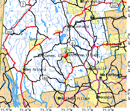
Points of interest:
Notable locations in Bethlehem: Bethlehem Fairgrounds (A), Paradise Valley Farm (B), Old Bethlehem Historical Museum (C), Bethlehem Town Hall (D), Bethlehem Public Library (E), Bellamy-Ferriday House (F), Abbey of Regina Laudis Library (G), Bethlehem Ambulance Association (H), Bethlehem Volunteer Fire Department (I). Display/hide their locations on the map
Churches in Bethlehem include: Church of the Nativity (A), First Church of Bethlehem (B), Regina Laudis Priory (C). Display/hide their locations on the map
Cemeteries: Carmel Hill Cemetery (1), Evergreen Cemetery (2), Old Bethlehem Cemetery (3). Display/hide their locations on the map
Lakes and reservoirs: Zeiglers Pond (A), Bird Pond (B), Long Meadow Pond (C), Bronson E Lockwood Reservoir (D), Watertown Reservoir (E), Bronson E Rockwell Reservation (F). Display/hide their locations on the map
Creek: Wood Creek (A). Display/hide its location on the map
Parks in Bethlehem include: Bellamy-Ferriday Garden (1), Bethlehem Green Historic District (2). Display/hide their locations on the map
Tourist attractions: Old Bethlehem Historical Society (Museums; 4 Main Street North) (1), Riding Center (Amusement & Theme Parks; 106 Cabbage Ln) (2). Display/hide their approximate locations on the map
Drinking water stations with addresses in Bethlehem and their reported violations in the past:
NORTH PURCHASE ELDERLY HOUSING (Population served: 72, Groundwater):Past health violations:Past monitoring violations:
- MCL, Monthly (TCR) - In AUG-2005, Contaminant: Coliform. Follow-up actions: St Public Notif received (SEP-01-2005), St Public Notif requested (SEP-12-2005), St Violation/Reminder Notice (SEP-12-2005), St Compliance achieved (MAR-31-2006)
- 4 regular monitoring violations
| This town: | 2.5 people |
| Connecticut: | 2.5 people |
| This town: | 71.8% |
| Whole state: | 66.3% |
| This town: | 4.7% |
| Whole state: | 6.6% |
Likely homosexual households (counted as self-reported same-sex unmarried-partner households)
- Lesbian couples: 0.3% of all households
- Gay men: 0.4% of all households
| This town: | 2.6% |
| Whole state: | 7.9% |
| This town: | 1.4% |
| Whole state: | 3.9% |
People in group quarters in Bethlehem in 2010:
- 39 people in other noninstitutional facilities
- 30 people in workers' group living quarters and job corps centers
- 21 people in residential treatment centers for juveniles (non-correctional)
- 3 people in group homes intended for adults
People in group quarters in Bethlehem in 2000:
- 45 people in religious group quarters
- 19 people in mental (psychiatric) hospitals or wards
- 6 people in homes for the mentally retarded
- 4 people in college dormitories (includes college quarters off campus)
Banks with branches in Bethlehem (2011 data):
- Thomaston Savings Bank: Bethlehem Branch at 73 Main Street South, branch established on 1995/06/07. Info updated 2006/11/03: Bank assets: $692.2 mil, Deposits: $559.9 mil, headquarters in Thomaston, CT, positive income, Mortgage Lending Specialization, 9 total offices
For population 15 years and over in Bethlehem:
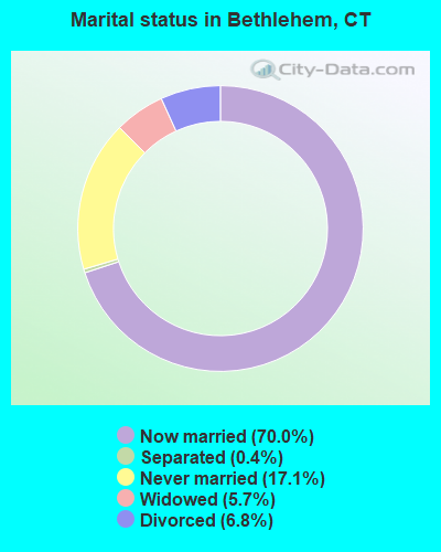
- Never married: 17.1%
- Now married: 70.0%
- Separated: 0.4%
- Widowed: 5.7%
- Divorced: 6.8%
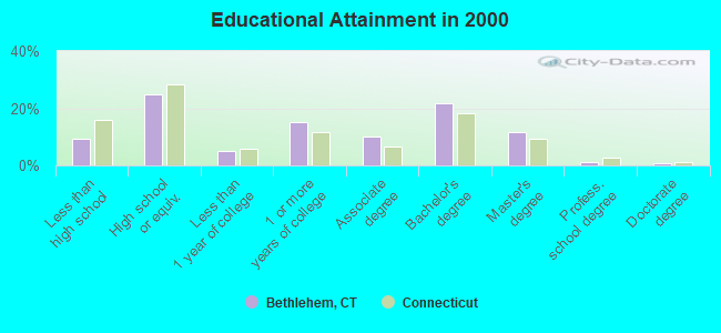
For population 25 years and over in Bethlehem:
- High school or higher: 90.6%
- Bachelor's degree or higher: 35.3%
- Graduate or professional degree: 13.6%
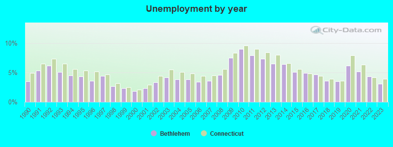
- Unemployed: 1.9%
- Mean travel time to work (commute): 29.9 minutes
| Here: | 10.2 |
| Connecticut average: | 12.8 |
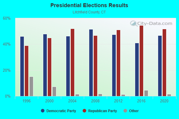
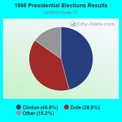
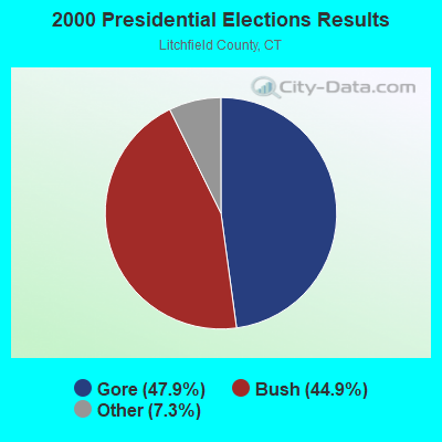
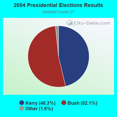
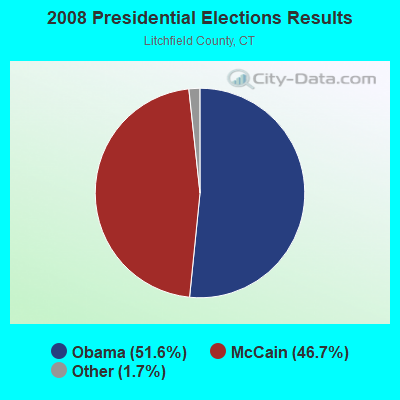
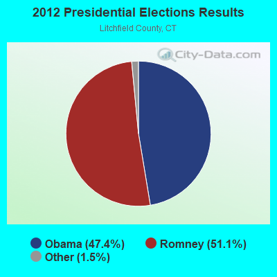
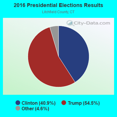
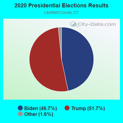
Graphs represent county-level data. Detailed 2008 Election Results
Religion statistics for Bethlehem, CT (based on Litchfield County data)
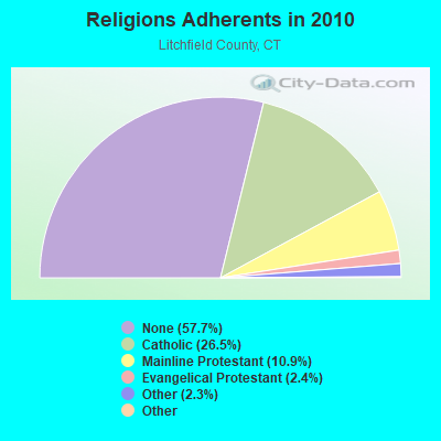
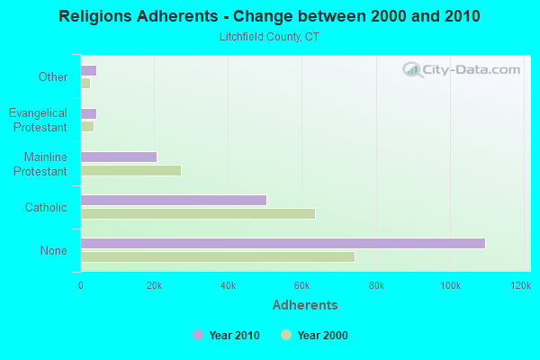
| Religion | Adherents | Congregations |
|---|---|---|
| Catholic | 50,354 | 30 |
| Mainline Protestant | 20,681 | 87 |
| Evangelical Protestant | 4,483 | 39 |
| Other | 4,420 | 16 |
| Orthodox | 175 | 2 |
| Black Protestant | 160 | 2 |
| None | 109,654 | - |
Food Environment Statistics:
| Litchfield County: | 2.29 / 10,000 pop. |
| Connecticut: | 2.21 / 10,000 pop. |
| This county: | 0.05 / 10,000 pop. |
| State: | 0.07 / 10,000 pop. |
| Litchfield County: | 0.64 / 10,000 pop. |
| Connecticut: | 1.02 / 10,000 pop. |
| Litchfield County: | 2.98 / 10,000 pop. |
| State: | 2.27 / 10,000 pop. |
| Here: | 11.07 / 10,000 pop. |
| State: | 9.19 / 10,000 pop. |
| This county: | 6.9% |
| Connecticut: | 7.3% |
| Litchfield County: | 21.1% |
| Connecticut: | 21.5% |
| This county: | 11.8% |
| State: | 15.8% |
Businesses in Bethlehem, CT
- Curves: 1
- Goodwill: 1
- True Value: 1
Strongest AM radio stations in Bethlehem:
- WTIC (1080 AM; 50 kW; HARTFORD, CT; Owner: INFINITY RADIO OPERATIONS INC.)
- WNNZ (640 AM; 50 kW; WESTFIELD, MA; Owner: CLEAR CHANNEL BROADCASTING LICENSES, INC.)
- WATR (1320 AM; 5 kW; WATERBURY, CT; Owner: WATR, INC.)
- WFNW (1380 AM; 5 kW; NAUGATUCK, CT; Owner: CANDIDO DIAS CARRELO)
- WFAN (660 AM; 50 kW; NEW YORK, NY; Owner: INFINITY BROADCASTING OPERATIONS, INC.)
- WCBS (880 AM; 50 kW; NEW YORK, NY; Owner: INFINITY BROADCASTING OPERATIONS, INC.)
- WMCA (570 AM; 50 kW; NEW YORK, NY; Owner: SALEM MEDIA OF NEW YORK, LLC)
- WABC (770 AM; 50 kW; NEW YORK, NY; Owner: WABC-AM RADIO, INC.)
- WOR (710 AM; 50 kW; NEW YORK, NY; Owner: BUCKLEY BROADCASTING CORPORATION)
- WLAT (910 AM; 5 kW; NEW BRITAIN, CT; Owner: MEGA COMMUNICATIONS OF NEW BRITAIN LICENSEE, LLC)
- WSNG (610 AM; 1 kW; TORRINGTON, CT; Owner: BUCKLEY BROADCASTING CORPORATION OF)
- WADS (690 AM; daytime; 3 kW; ANSONIA, CT; Owner: RADIO AMOR, INC.)
- WGSM (740 AM; 25 kW; HUNTINGTON, NY; Owner: K RADIO LICENSEE, INC.)
Strongest FM radio stations in Bethlehem:
- W218AV (91.5 FM; WARREN, CT; Owner: MONROE BOARD OF EDUCATION)
- WRCH (100.5 FM; NEW BRITAIN, CT; Owner: INFINITY RADIO OPERATIONS INC.)
- WKCI-FM (101.3 FM; HAMDEN, CT; Owner: CLEAR CHANNEL BROADCASTING LICENSES, INC.)
- WJMJ (88.9 FM; HARTFORD, CT; Owner: ST. THOMAS SEMINARY)
- WPLR (99.1 FM; NEW HAVEN, CT; Owner: COX RADIO, INC.)
- WRKI (95.1 FM; BROOKFIELD, CT; Owner: CUMULUS LICENSING CORP.)
- WWYZ (92.5 FM; WATERBURY, CT; Owner: CAPSTAR TX LIMITED PARTNERSHIP)
- WKSS (95.7 FM; HARTFORD-MERIDEN, CT; Owner: CAPSTAR TX LIMITED PARTNERSHIP)
- WZMX (93.7 FM; HARTFORD, CT; Owner: INFINITY RADIO OPERATIONS INC.)
- WHCN (105.9 FM; HARTFORD, CT; Owner: CAPSTAR TX LIMITED PARTNERSHIP)
- WMRQ (104.1 FM; WATERBURY, CT; Owner: CAPSTAR TX LIMITED PARTNERSHIP)
- WPKT (90.5 FM; MERIDEN, CT; Owner: CONNECTICUT PUBLIC BROADCASTING, INC)
- WDRC-FM (102.9 FM; HARTFORD, CT; Owner: BUCKLEY BROADCASTING CORPORATION)
- W206AW (89.1 FM; PAWLING, NY; Owner: SOUND OF LIFE, INC.)
- WTIC-FM (96.5 FM; HARTFORD, CT; Owner: INFINITY RADIO OPERATIONS INC.)
- WZBG (97.3 FM; LITCHFIELD, CT; Owner: LOCAL GIRLS & BOYS B/CASTING CORP.)
- WWUH (91.3 FM; WEST HARTFORD, CT; Owner: UNIVERSITY OF HARTFORD)
- WQQQ (103.3 FM; SHARON, CT; Owner: THE RIDGEFIELD BROADCASTING CORPORATION)
- WPDH (101.5 FM; POUGHKEEPSIE, NY; Owner: CUMULUS LICENSING CORP.)
- WCCC-FM (106.9 FM; HARTFORD, CT; Owner: MARLIN BROADCASTING, LLC)
TV broadcast stations around Bethlehem:
- WTIC-TV (Channel 61; HARTFORD, CT; Owner: TRIBUNE TELEVISION COMPANY)
- W11BJ (Channel 11; HARTFORD, CT; Owner: COMMUNICATIONS SITE MANAGEMENT LLC)
- WTXX (Channel 20; WATERBURY, CT; Owner: WTXX INC.)
- WVIT (Channel 30; NEW BRITAIN, CT; Owner: OUTLET BROADCASTING, INC)
- WEDH (Channel 24; HARTFORD, CT; Owner: CONNECTICUT PUBLIC BROADCASTING, INC.)
- WTNH (Channel 8; NEW HAVEN, CT; Owner: WTNH BROADCASTING, INC.)
- WUVN (Channel 18; HARTFORD, CT; Owner: ENTRAVISION HOLDINGS, LLC)
- WCTX (Channel 59; NEW HAVEN, CT; Owner: WTNH BROADCASTING, INC.)
- WEDY (Channel 65; NEW HAVEN, CT; Owner: CONNECTICUT PUBLIC BROADCASTING, INC.)
- WFSB (Channel 3; HARTFORD, CT; Owner: MEREDITH CORPORATION)
- W12BH (Channel 12; WATERBURY, CT; Owner: CONN.PUBLIC BROADCASTING, INC.)
- WEDW (Channel 49; BRIDGEPORT, CT; Owner: CONNECTICUT PUBLIC BROADCASTING, INC.)
- WTBY (Channel 54; POUGHKEEPSIE, NY; Owner: TRINITY BROADCASTING OF NEW YORK, INC.)
- WHCT-LP (Channel 38; HARTFORD, CT; Owner: VENTURE TECHNOLOGIES GROUP, LLC)
- WSAH (Channel 43; BRIDGEPORT, CT; Owner: WSAH LICENSE, INC.)
- National Bridge Inventory (NBI) Statistics
- 8Number of bridges
- 39ft / 12.5mTotal length
- $4,388,000Total costs
- 108,787Total average daily traffic
- 9,679Total average daily truck traffic
- 161,648Total future (year 2035) average daily traffic
FCC Registered Antenna Towers:
2- Edward G Roach, 2 Carmel Hill Road North (Lat: 41.620333 Lon: -73.244222), Type: 60.7, Overall height: 56.1 m, Registrant: None
- Edward G Roach, 2 Carmel Hill Road North (Lat: 41.620333 Lon: -73.244222), Type: 60.7, Overall height: 56.1 m, Registrant: None
FCC Registered Maritime Coast & Aviation Ground Towers:
1- Whelan Farms Airport (Lat: 41.667028 Lon: -73.183167), Type: Building, Overall height: 4 m, Call Sign: KIG4,
Assigned Frequencies: 122.725 MHz, Grant Date: 02/14/2019, Expiration Date: 12/15/2028, Registrant: Business Radio Licensing, 30251 Golden Lantern, Suite E # 501, Laguna Niguel, CA 92677, Phone: (949) 348-8510, Fax: (949) 348-8514, Email:
FCC Registered Amateur Radio Licenses:
28 (See the full list of FCC Registered Amateur Radio Licenses in Bethlehem)FAA Registered Aircraft Manufacturers and Dealers:
2- WHELAN FARMS AIRPORT LLC, Po Box 426, Bethlehem, CT 06751
Certificate: D005136 (LLC), Certificate Issue Date: 11/02/2020, Expiration Date: 11/01/2021 - WHELAN FARMS AIRPORT LLC, Po Box 426, Bethlehem, CT 06751
Certificate: D005136 (Corporation), Certificate Issue Date: 10/04/2017, Expiration Date: 10/03/2018
FAA Registered Aircraft:
4- Aircraft: GRUMMAN AMERICAN AVN. CORP. AA-5B (Category: Land, Seats: 4, Weight: Up to 12,499 Pounds, Speed: 105 mph), Engine: LYCOMING O&VO-360 SER (180 HP) (Reciprocating)
N-Number: 1558R, N1558R, N-1558R, Serial Number: AA5B-0058, Year manufactured: 1975, Airworthiness Date: 04/29/1975, Certificate Issue Date: 04/11/2017
Registrant (Individual): Scott Douglas Taylor, 197 Kasson Rd, Bethlehem, CT 06751 - Aircraft: FAIRCHILD 24W-41A (Category: Land, Seats: 4, Weight: Up to 12,499 Pounds, Speed: 102 mph), Engine: WARNER SS165 SERIES (175 HP) (Reciprocating)
N-Number: 28691, N28691, N-28691, Serial Number: W41A-201, Year manufactured: 1941, Airworthiness Date: 07/30/1956, Certificate Issue Date: 01/07/2011
Registrant (Individual): Thomas M Whelan, Po Box 426, Bethlehem, CT 06751 - Aircraft: CHAMPION 7CCM (Category: Land, Seats: 2, Weight: Up to 12,499 Pounds, Speed: 90 mph), Engine: CONT MOTOR C90 SERIES (95 HP) (Reciprocating)
N-Number: 4507E, N4507E, N-4507E, Serial Number: 7CCM-113, Year manufactured: 1948, Airworthiness Date: 01/14/1956, Certificate Issue Date: 08/27/2014
Registrant (LLC): Whelan Farms Airport LLC, Po Box 426, Bethlehem, CT 06751 - Aircraft: CESSNA 172N (Category: Land, Seats: 4, Weight: Up to 12,499 Pounds, Speed: 105 mph), Engine: LYCOMING 0-320 SERIES (180 HP) (Reciprocating)
N-Number: 733MU, N733MU, N-733MU, Serial Number: 17268404, Year manufactured: 1976, Airworthiness Date: 01/06/1977, Certificate Issue Date: 02/21/2017
Registrant (LLC): 733mu LLC, 356 Munger Ln, Bethlehem, CT 06751
2002 - 2018 National Fire Incident Reporting System (NFIRS) incidents
- Fire incident types reported to NFIRS in Bethlehem, CT
- 11549.4%Structure Fires
- 7130.5%Outside Fires
- 2410.3%Other
- 239.9%Mobile Property/Vehicle Fires
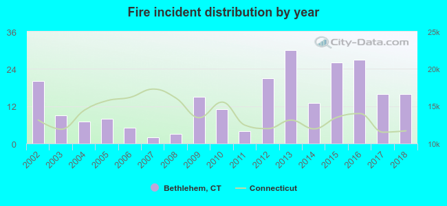 Based on the data from the years 2002 - 2018 the average number of fire incidents per year is 14. The highest number of reported fires - 30 took place in 2013, and the least - 2 in 2007. The data has a dropping trend.
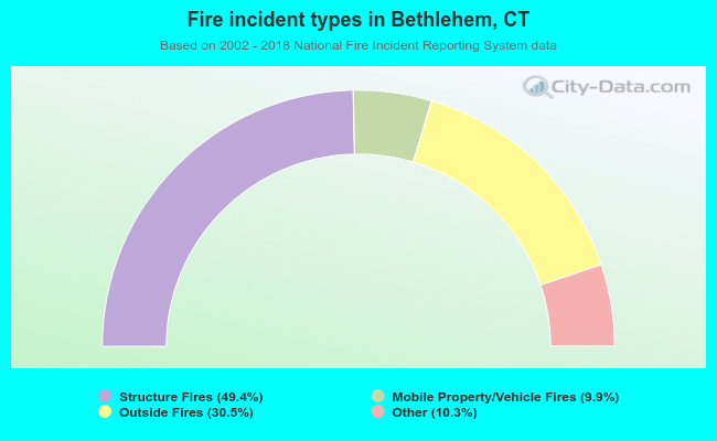 When looking into fire subcategories, the most incidents belonged to: Structure Fires (49.4%), and Outside Fires (30.5%).
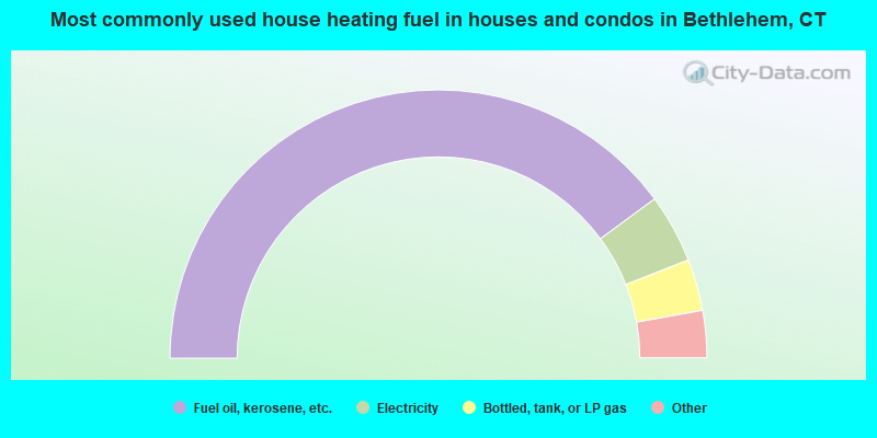
- 79.8%Fuel oil, kerosene, etc.
- 8.3%Electricity
- 6.2%Bottled, tank, or LP gas
- 3.7%Wood
- 1.0%Solar energy
- 0.6%Coal or coke
- 0.5%Utility gas
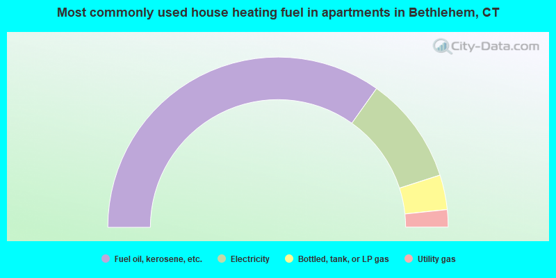
- 69.6%Fuel oil, kerosene, etc.
- 20.4%Electricity
- 6.6%Bottled, tank, or LP gas
- 3.3%Utility gas
Bethlehem compared to Connecticut state average:
- Unemployed percentage significantly below state average.
- Black race population percentage significantly below state average.
- Hispanic race population percentage significantly below state average.
- Median age above state average.
- Foreign-born population percentage significantly below state average.
- Renting percentage below state average.
- Length of stay since moving in significantly above state average.
- Number of rooms per house significantly below state average.
- House age significantly below state average.
Bethlehem on our top lists:
- #42 on the list of "Top 101 cities with the largest percentage of people in religious group quarters (population 1,000+)"
- #7 on the list of "Top 101 counties with the lowest Particulate Matter (PM10) Annual air pollution readings in 2012 (µg/m3)"
- #10 on the list of "Top 101 counties with the lowest number of births per 1000 residents 2007-2013"
- #21 on the list of "Top 101 counties with the largest decrease in the number of births per 1000 residents 2000-2006 to 2007-2013 (pop 50,000+)"
- #38 on the list of "Top 101 counties with the lowest Particulate Matter (PM2.5) Annual air pollution readings in 2012 (µg/m3)"
- #39 on the list of "Top 101 counties with the highest carbon monoxide air pollution readings in 2012 (ppm)"

|
|
Total of 83 patent applications in 2008-2024.