Clairfield, Tennessee
Submit your own pictures of this place and show them to the world
- OSM Map
- General Map
- Google Map
- MSN Map

| Males: 515 | |
| Females: 524 |
| Median resident age: | 34.7 years |
| Tennessee median age: | 35.9 years |
Zip code: 37870
| Clairfield: | $26,348 |
| TN: | $65,254 |
Estimated per capita income in 2022: $14,251 (it was $7,177 in 2000)
Clairfield CCD income, earnings, and wages data
Estimated median house or condo value in 2022: $53,892 (it was $20,500 in 2000)
| Clairfield: | $53,892 |
| TN: | $284,800 |
Detailed information about poverty and poor residents in Clairfield, TN


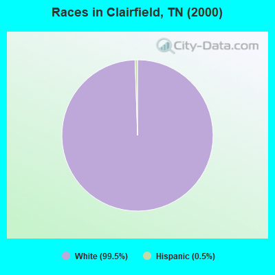
- 99799.5%White alone
- 50.5%Hispanic
Races in Clairfield detailed stats: ancestries, foreign born residents, place of birth
According to our research of Tennessee and other state lists, there was 1 registered sex offender living in Clairfield, Tennessee as of June 16, 2024.
The ratio of all residents to sex offenders in Clairfield is 1,039 to 1.
The ratio of registered sex offenders to all residents in this city is much lower than the state average.
 Recent articles from our blog. Our writers, many of them Ph.D. graduates or candidates, create easy-to-read articles on a wide variety of topics.
Current Local Time: EST time zone
Elevation: 1107 feet
Land area: 73.9 square miles.
Population density: 14 people per square mile (very low).

| Clairfield CCD: | 1.0% ($199) |
| Tennessee: | 0.8% ($715) |
Nearest city with pop. 50,000+: Knoxville, TN  (39.7 miles , pop. 173,890).
Nearest city with pop. 200,000+: Fayette, KY (107.7 miles , pop. 260,512).
Nearest city with pop. 1,000,000+: Chicago, IL (418.4 miles , pop. 2,896,016).
Nearest cities:
), ), ), ), ), Latitude: 36.55 N, Longitude: 83.90 W
Area code commonly used in this area: 423

| Here: | 3.5% |
| Tennessee: | 3.0% |
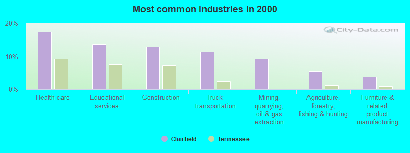
- Health care (17.5%)
- Educational services (13.6%)
- Construction (12.9%)
- Truck transportation (11.4%)
- Mining, quarrying, oil & gas extraction (9.3%)
- Agriculture, forestry, fishing & hunting (5.4%)
- Furniture & related product manufacturing (3.9%)
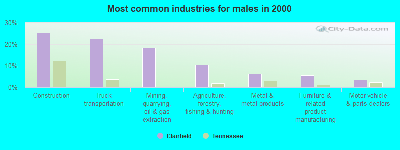
- Construction (25.4%)
- Truck transportation (22.5%)
- Mining, quarrying, oil & gas extraction (18.3%)
- Agriculture, forestry, fishing & hunting (10.6%)
- Metal & metal products (6.3%)
- Furniture & related product manufacturing (5.6%)
- Motor vehicle & parts dealers (3.5%)
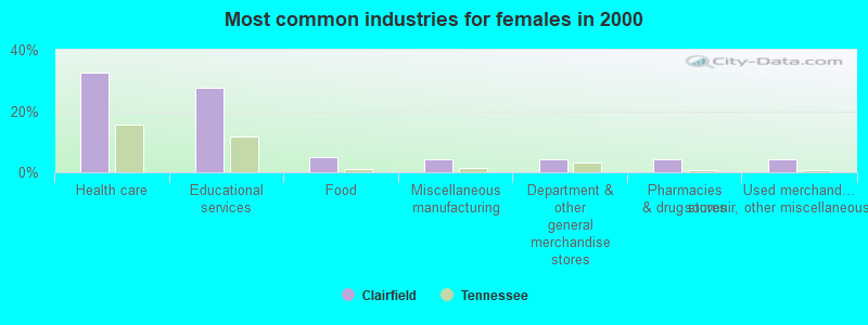
- Health care (32.6%)
- Educational services (27.5%)
- Food (5.1%)
- Miscellaneous manufacturing (4.3%)
- Department & other general merchandise stores (4.3%)
- Pharmacies & drug stores (4.3%)
- Used merchandise, gift, novelty, souvenir, other miscellaneous stores (4.3%)
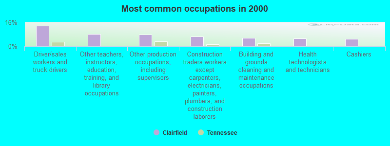
- Driver/sales workers and truck drivers (13.6%)
- Other teachers, instructors, education, training, and library occupations (8.2%)
- Other production occupations, including supervisors (7.9%)
- Construction traders workers except carpenters, electricians, painters, plumbers, and construction laborers (6.4%)
- Building and grounds cleaning and maintenance occupations (5.7%)
- Health technologists and technicians (5.4%)
- Cashiers (5.0%)
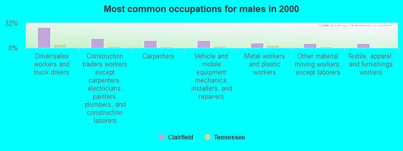
- Driver/sales workers and truck drivers (26.8%)
- Construction traders workers except carpenters, electricians, painters, plumbers, and construction laborers (12.7%)
- Carpenters (9.9%)
- Vehicle and mobile equipment mechanics, installers, and repairers (9.9%)
- Metal workers and plastic workers (6.3%)
- Other material moving workers, except laborers (5.6%)
- Textile, apparel, and furnishings workers (5.6%)
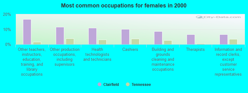
- Other teachers, instructors, education, training, and library occupations (16.7%)
- Other production occupations, including supervisors (11.6%)
- Health technologists and technicians (10.9%)
- Cashiers (10.1%)
- Building and grounds cleaning and maintenance occupations (8.7%)
- Therapists (6.5%)
- Information and record clerks, except customer service representatives (6.5%)
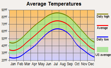
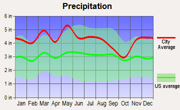
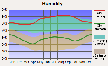
Average climate in Clairfield, Tennessee
Based on data reported by over 4,000 weather stations
(lower is better)
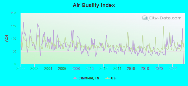
Air Quality Index (AQI) level in 2023 was 80.8. This is about average.
| City: | 80.8 |
| U.S.: | 72.6 |
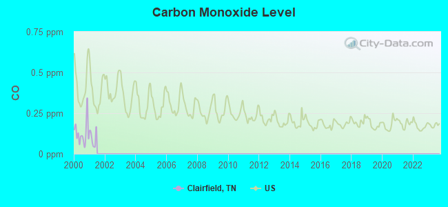
Carbon Monoxide (CO) [ppm] level in 2000 was 0.127. This is significantly better than average. Closest monitor was 10.0 miles away from the city center.
| City: | 0.127 |
| U.S.: | 0.251 |
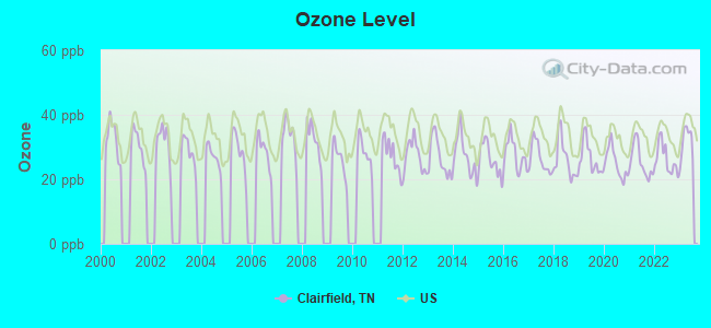
Ozone [ppb] level in 2023 was 31.6. This is about average. Closest monitor was 6.7 miles away from the city center.
| City: | 31.6 |
| U.S.: | 33.3 |
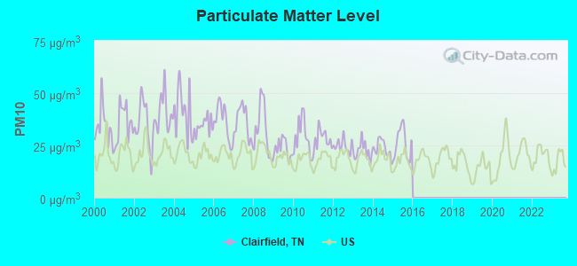
Particulate Matter (PM10) [µg/m3] level in 2015 was 26.0. This is worse than average. Closest monitor was 10.0 miles away from the city center.
| City: | 26.0 |
| U.S.: | 19.2 |
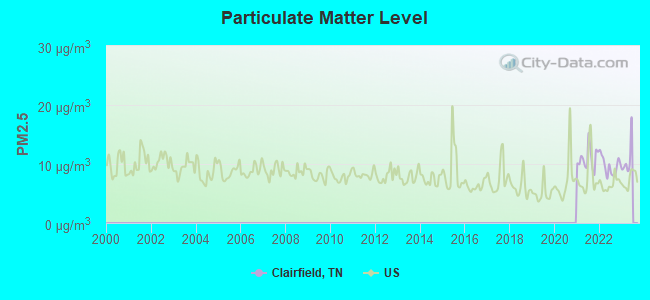
Particulate Matter (PM2.5) [µg/m3] level in 2022 was 9.68. This is about average. Closest monitor was 10.0 miles away from the city center.
| City: | 9.68 |
| U.S.: | 8.11 |
Tornado activity:
Clairfield-area historical tornado activity is significantly below Tennessee state average. It is 33% smaller than the overall U.S. average.
On 5/9/1988, a category F3 (max. wind speeds 158-206 mph) tornado 9.1 miles away from the Clairfield place center killed one person and injured 15 people and caused between $5,000,000 and $50,000,000 in damages.
On 3/12/1967, a category F3 tornado 15.0 miles away from the place center .
Earthquake activity:
Clairfield-area historical earthquake activity is significantly above Tennessee state average. It is 73% greater than the overall U.S. average.On 7/27/1980 at 18:52:21, a magnitude 5.2 (5.1 MB, 4.7 MS, 5.0 UK, 5.2 UK, Class: Moderate, Intensity: VI - VII) earthquake occurred 114.7 miles away from the city center
On 11/30/1973 at 07:48:41, a magnitude 4.7 (4.7 MB, 4.6 ML, Class: Light, Intensity: IV - V) earthquake occurred 51.8 miles away from the city center
On 8/9/2020 at 12:07:37, a magnitude 5.1 (5.1 MW, Depth: 4.7 mi) earthquake occurred 156.0 miles away from Clairfield center
On 4/18/2008 at 09:36:59, a magnitude 5.4 (5.1 MB, 4.8 MS, 5.4 MW, 5.2 MW) earthquake occurred 255.4 miles away from Clairfield center
On 8/23/2011 at 17:51:04, a magnitude 5.8 (5.8 MW, Depth: 3.7 mi) earthquake occurred 341.6 miles away from Clairfield center
On 9/7/1988 at 02:28:09, a magnitude 4.6 (4.5 MB, 4.6 LG) earthquake occurred 110.4 miles away from Clairfield center
Magnitude types: regional Lg-wave magnitude (LG), body-wave magnitude (MB), local magnitude (ML), surface-wave magnitude (MS), moment magnitude (MW)
Natural disasters:
The number of natural disasters in Claiborne County (15) is near the US average (15).Major Disasters (Presidential) Declared: 11
Emergencies Declared: 2
Causes of natural disasters: Floods: 11, Storms: 9, Tornadoes: 4, Winds: 3, Winter Storms: 3, Heavy Rain: 1, Hurricane: 1, Landslide: 1, Mudslide: 1, Snowfall: 1, Other: 1 (Note: some incidents may be assigned to more than one category).
Hospitals and medical centers near Clairfield:
- MIDDLESBORO HEALTH CARE FACILITY (Nursing Home, about 10 miles away; MIDDLESBORO, KY)
- MIDDLESBORO APPALACHIAN REGIONAL HEALTHCARE HOSPIT Acute Care Hospitals (about 10 miles away; MIDDLESBORO, KY)
- MIDDLESBORO ARH HOME HEALTH AGENCY (Home Health Center, about 12 miles away; MIDDLESBORO, KY)
- AMEDISYS HOME HEALTH CARE (Home Health Center, about 12 miles away; MIDDLESBORO, KY)
- BEECH TREE MANOR (Nursing Home, about 13 miles away; JELLICO, TN)
- JELLICO COMMUNITY HOSPITAL Acute Care Hospitals (about 13 miles away; JELLICO, TN)
- SUNBELT HOMECARE (Home Health Center, about 13 miles away; JELLICO, TN)
Colleges/universities with over 2000 students nearest to Clairfield:
- Lincoln Memorial University (about 14 miles; Harrogate, TN; Full-time enrollment: 3,706)
- University of the Cumberlands (about 20 miles; Williamsburg, KY; FT enrollment: 3,585)
- The University of Tennessee-Knoxville (about 41 miles; Knoxville, TN; FT enrollment: 25,483)
- Walters State Community College (about 43 miles; Morristown, TN; FT enrollment: 4,359)
- Pellissippi State Community College (about 44 miles; Knoxville, TN; FT enrollment: 7,271)
- Somerset Community College (about 54 miles; Somerset, KY; FT enrollment: 4,698)
- Southeast Kentucky Community and Technical College (about 59 miles; Cumberland, KY; FT enrollment: 2,196)
Public elementary/middle school in Clairfield:
- CLAIRFIELD ELEMENTARY (Students: 134, Location: 6360 HWY 90, Grades: KG-8)
Points of interest:
Notable location: Clear Fork Volunteer Fire Department (A). Display/hide its location on the map
Churches in Clairfield include: Days Chapel (A), Rising Spring Church (B), Valley Creek Missionary Baptist Church (C), Eagan Baptist Church (D), Clairfield Missionary Baptist Church (E). Display/hide their locations on the map
Cemeteries: Bostica Cemetery (1), Hatfield Cemetery (2). Display/hide their locations on the map
Reservoirs: Consolidation Coal Water Supply Lake (A), Spruce Lick Slurry Refuse Impound (B). Display/hide their locations on the map
Streams, rivers, and creeks: Little Tackett Creek (A), Hurricane Creek (B), Tracy Branch (C), Straight Creek (D), Fox Branch (E), Coal Creek (F), Buffalo Creek (G), Kings Branch (H), Cabin Creek (I). Display/hide their locations on the map
Drinking water stations with addresses in Clairfield and their reported violations in the past:
CLEAR FORK UTILITY DISTRICT (Population served: 1,807, Groundwater):Past monitoring violations:
- Monitoring and Reporting (DBP) - Between JUL-2011 and SEP-2011, Contaminant: Chlorine. Follow-up actions: St Public Notif requested (OCT-03-2011), St Violation/Reminder Notice (OCT-03-2011), St Compliance achieved (DEC-31-2011), St Public Notif received (JUN-11-2012)
- Monitoring and Reporting (DBP) - Between JUL-2008 and SEP-2008, Contaminant: Chlorine. Follow-up actions: St Compliance achieved (SEP-30-2008), St Violation/Reminder Notice (OCT-03-2008), St Public Notif requested (OCT-03-2008), St Public Notif received (JUN-30-2009)
- Monitoring and Reporting (DBP) - Between JUL-2006 and SEP-2006, Contaminant: TTHM. Follow-up actions: St Public Notif requested (OCT-27-2006), St Violation/Reminder Notice (OCT-27-2006), St Compliance achieved (NOV-02-2006)
- Monitoring and Reporting (DBP) - Between JUL-2006 and SEP-2006, Contaminant: Total Haloacetic Acids (HAA5). Follow-up actions: St Violation/Reminder Notice (OCT-27-2006), St Public Notif requested (OCT-27-2006), St Compliance achieved (NOV-02-2006)
- One routine major monitoring violation
- One minor monitoring violation
| This place: | 2.7 people |
| Tennessee: | 2.5 people |
| This place: | 70.9% |
| Whole state: | 69.8% |
| This place: | 2.7% |
| Whole state: | 4.2% |
Likely homosexual households (counted as self-reported same-sex unmarried-partner households)
- Lesbian couples: 0.3% of all households
- Gay men: 0.0% of all households
| This place: | 38.5% |
| Whole state: | 13.5% |
| This place: | 17.9% |
| Whole state: | 5.8% |
For population 15 years and over in Clairfield:
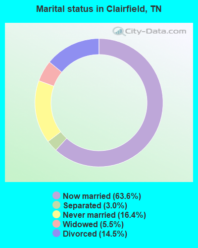
- Never married: 16.4%
- Now married: 63.6%
- Separated: 3.0%
- Widowed: 5.5%
- Divorced: 14.5%
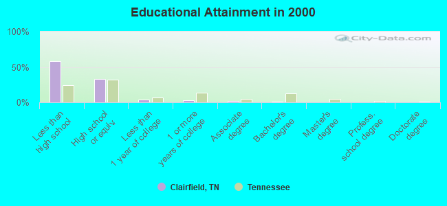
For population 25 years and over in Clairfield:
- High school or higher: 42.1%
- Bachelor's degree or higher: 0.8%
- Graduate or professional degree: 0.0%
- Unemployed: 19.3%
- Mean travel time to work (commute): 48.9 minutes
| Here: | 21.4 |
| Tennessee average: | 13.3 |
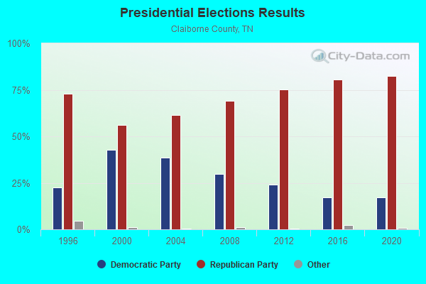
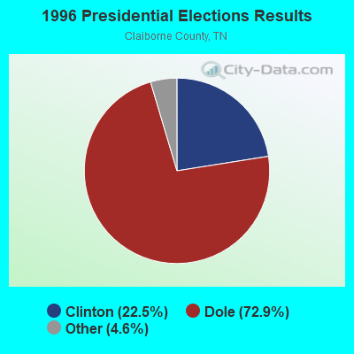
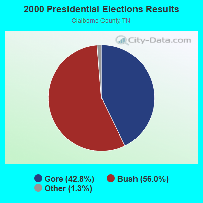
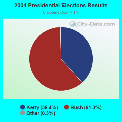
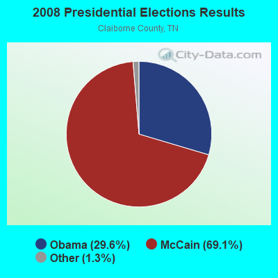
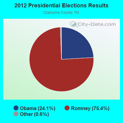
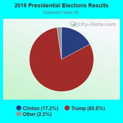
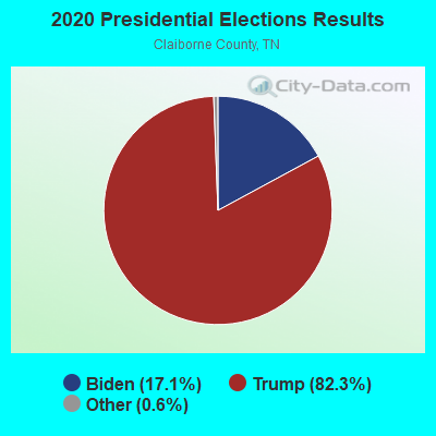
Graphs represent county-level data. Detailed 2008 Election Results
Religion statistics for Clairfield, TN (based on Claiborne County data)
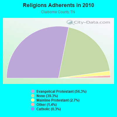
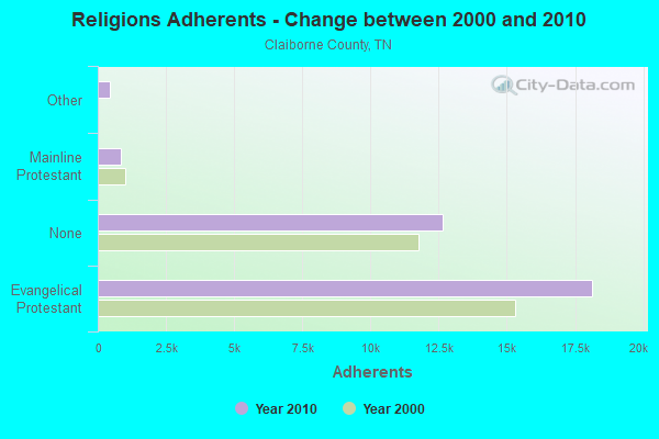
| Religion | Adherents | Congregations |
|---|---|---|
| Evangelical Protestant | 18,142 | 81 |
| Mainline Protestant | 860 | 9 |
| Other | 452 | 2 |
| Catholic | 110 | 1 |
| None | 12,649 | - |
Food Environment Statistics:
| Claiborne County: | 2.24 / 10,000 pop. |
| State: | 1.99 / 10,000 pop. |
| This county: | 0.64 / 10,000 pop. |
| Tennessee: | 0.65 / 10,000 pop. |
| This county: | 3.21 / 10,000 pop. |
| State: | 5.16 / 10,000 pop. |
| Claiborne County: | 2.89 / 10,000 pop. |
| Tennessee: | 6.56 / 10,000 pop. |
| Here: | 11.2% |
| Tennessee: | 11.4% |
| Claiborne County: | 30.0% |
| Tennessee: | 30.2% |
| Here: | 16.4% |
| State: | 13.5% |
Strongest AM radio stations in Clairfield:
- WKVL (850 AM; daytime; 50 kW; KNOXVILLE, TN; Owner: HORNE RADIO, LLC)
- WMIK (560 AM; 2 kW; MIDDLESBORO, KY; Owner: GATEWAY BROADCASTING, INC.)
- WEKC (710 AM; daytime; 4 kW; WILLIAMSBURG, KY; Owner: GERALD PARKS)
- WNOX (990 AM; 10 kW; KNOXVILLE, TN)
- WQBB (1040 AM; daytime; 10 kW; POWELL, TN; Owner: JOURNAL BROADCAST CORPORATION)
- WRWB (740 AM; 1 kW; HARROGATE, TN; Owner: PINE HILLS OF TENNESSEE, INC.)
- WVLZ (1180 AM; daytime; 10 kW; KNOXVILLE, TN; Owner: KIRKLAND WIRELESS BROADCASTERS, INC.)
- WEZJ (1440 AM; 2 kW; WILLIAMSBURG, KY; Owner: WHITLEY BROADCASTING CO., INC.)
- WFXY (1490 AM; 1 kW; MIDDLESBORO, KY; Owner: COUNTRY WIDE BROADCASTERS, INC.)
- WRJZ (620 AM; 5 kW; KNOXVILLE, TN; Owner: TENNESSEE MEDIA ASSOCIATES, INC)
- WKDP (1330 AM; 5 kW; CORBIN, KY; Owner: EUBANKS BROADCASTING, INC.)
- WFGW (1010 AM; 50 kW; BLACK MOUNTAIN, NC; Owner: BLUE RIDGE BROADCASTING CORP.)
- WLFJ (660 AM; daytime; 50 kW; GREENVILLE, SC; Owner: CLEAR CHANNEL BROADCASTING LICENSES, INC.)
Strongest FM radio stations in Clairfield:
- WMIK-FM (92.7 FM; MIDDLESBORO, KY; Owner: GATEWAY BROADCASTING, INC.)
- WCTU (105.9 FM; TAZEWELL, TN; Owner: STAIR COMPANY, INC)
- WDVX (89.9 FM; CLINTON, TN; Owner: CUMBERLAND COMMUNITIES COMMUNI CORP.)
- WEKX (102.7 FM; JELLICO, TN; Owner: WHITLEY BROADCASTING CO., INC.)
- WIMZ-FM (103.5 FM; KNOXVILLE, TN; Owner: SOUTH CENTRAL COMM., CORP.)
- WRIL (106.3 FM; PINEVILLE, KY; Owner: PINE HILLS BROADCASTING, INC.)
- WOKI-FM (100.3 FM; OAK RIDGE, TN; Owner: OAK RIDGE FM, INC.)
- WUOT (91.9 FM; KNOXVILLE, TN; Owner: UNIVERSITY OF TENNESSEE)
- WQLA-FM (104.9 FM; LA FOLLETTE, TN; Owner: LAFOLLETTE BROADCASTERS, INC.)
- WEZJ-FM (104.3 FM; WILLIAMSBURG, KY; Owner: WHITLEY BROADCASTING CO., INC.)
- WIVK-FM (107.7 FM; KNOXVILLE, TN; Owner: CITADEL BROADCASTING COMPANY)
- WJXB-FM (97.5 FM; KNOXVILLE, TN; Owner: SOUTH CENTRAL COMMUNICATIONS CORP.)
- WWST (102.1 FM; SEVIERVILLE, TN; Owner: JOURNAL BROADCAST CORPORATION)
- WLMU (91.3 FM; HARROGATE, TN; Owner: LINCOLN MEMORIAL UNIVERSITY)
- WJDT (106.5 FM; ROGERSVILLE, TN; Owner: C & S BROADCASTING)
- WBGQ (100.7 FM; BULLS GAP, TN; Owner: CHEROKEE BROADCASTING)
- WRMX-FM (106.7 FM; NORRIS, TN; Owner: SOUTH CENTRAL COMMUNICATIONS CORPORATION)
- WKDP-FM (99.5 FM; CORBIN, KY; Owner: EUBANKS BROADCASTING, INC.)
- WSEH (102.7 FM; CUMBERLAND, KY; Owner: CUMBERLAND CITY BROADCASTING, INC.)
- WYLV (89.1 FM; ALCOA, TN; Owner: FOOTHILLS BROADCASTING, INC.)
TV broadcast stations around Clairfield:
- WKOP-TV (Channel 15; KNOXVILLE, TN; Owner: EAST TENNESSEE PUBLIC COMMUNICATIONS CORP.)
- WVLT-TV (Channel 8; KNOXVILLE, TN; Owner: WVLT LICENSEE CORP.)
- WBIR-TV (Channel 10; KNOXVILLE, TN; Owner: GANNETT PACIFIC CORPORATION)
- WATE-TV (Channel 6; KNOXVILLE, TN; Owner: WATE, G.P.)
- WTNZ (Channel 43; KNOXVILLE, TN; Owner: RAYCOM AMERICA, INC.)
- WEEE-LP (Channel 32; KNOXVILLE, TN; Owner: TIGER EYE BROADCASTING CORPORATION)
- WEZK-LP (Channel 28; KNOXVILLE, TN; Owner: SOUTH CENTRAL COMMUNICATIONS CORP.)
- WPXK (Channel 54; JELLICO, TN; Owner: PAXSON KNOXVILLE LICENSE, INC.)
Clairfield fatal accident list:
FCC Registered Antenna Towers:
7- Brandon Smith, 5637 Highway 90 (Lat: 36.558861 Lon: -83.944417), Type: 89.9, Structure height: 47025 m, Overall height: 85.3 m, Registrant: Environmental Corporation Of America, Eric.Johnson@eca-Usa.Com, , Alpha-retta, Phone: (770) 667-2040
- Brandon Smith, 5637 Highway 90 (Lat: 36.558861 Lon: -83.944417), Type: 89.9, Structure height: 47025 m, Overall height: 85.3 m, Registrant: Environmental Corporation Of America, Eric.Johnson@eca-Usa.Com, , Alpha-retta, Phone: (770) 667-2040
- Robert P Walters, 5637 Highway 90 (Lat: 36.558861 Lon: -83.944417), Type: 89.9, Structure height: 47025 m, Overall height: 85.3 m, Registrant: Environmental Corporation Of America, Eric.Johnson@eca-Usa.Com, , Alpha-retta, Phone: (770) 667-2040
- Robert P Walters, 5637 Highway 90 (Lat: 36.558861 Lon: -83.944417), Type: 89.9, Structure height: 47025 m, Overall height: 85.3 m, Registrant: At&t Services, Inc., Fccmw@att.Com, , Dalla-s, Phone: (855) 699-7073
- Alyssa Culver, 5637 Highway 90 (Lat: 36.558861 Lon: -83.944417), Type: 89.9, Structure height: 47025 m, Overall height: 85.3 m, Registrant: Uniti Towers LLC, Dl_regulatory@uniti.Com, Suite 100, Littl-e Rock, Phone: (501) 850-0820
- Alyssa Culver, 5637 Highway 90 (Lat: 36.558861 Lon: -83.944417), Type: 89.9, Structure height: 47025 m, Overall height: 85.3 m, Registrant: Uniti Towers LLC, Dl_regulatory@uniti.Com, Suite 100, Littl-e Rock, Phone: (501) 850-0820
- Alyssa Culver, 5637 Highway 90 (Lat: 36.558861 Lon: -83.944417), Type: 89.9, Structure height: 47025 m, Overall height: 85.3 m, Registrant: Uniti Towers LLC, Dl_regulatory@uniti.Com, Suite 100, Littl-e Rock, Phone: (501) 850-0820
FCC Registered Amateur Radio Licenses:
3- Call Sign: KI4ALX, Licensee ID: L00687406, Grant Date: 08/12/2013, Expiration Date: 05/19/2023, Certifier: Michael L Grace Ii, Registrant: Michael L Grace Ii, 137 Brewer Hill, Clairfield, TN 37715
- Call Sign: KJ4DFQ, Licensee ID: L01389219, Grant Date: 03/20/2018, Expiration Date: 04/11/2028, Certifier: Aaron J Gaylor, Registrant: Aaron J Gaylor, 693 Tracey Branch Rd, Clairfield, TN 37715
- Call Sign: KJ4OVU, Licensee ID: L01403041, Grant Date: 12/24/2019, Expiration Date: 12/24/2029, Certifier: Dean S Baird Jr, Registrant: Dean S Baird Jr, 4136 Hwy 90, Clairfield, TN 37715
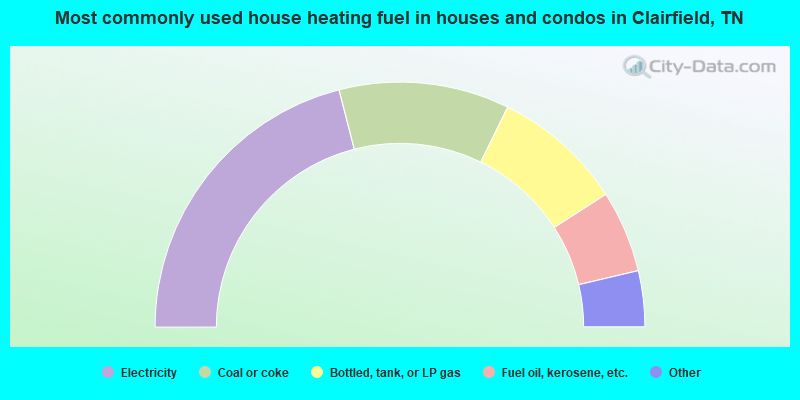
- 42.0%Electricity
- 22.5%Coal or coke
- 17.3%Bottled, tank, or LP gas
- 10.8%Fuel oil, kerosene, etc.
- 3.4%Wood
- 1.9%Utility gas
- 1.2%No fuel used
- 0.9%Other fuel
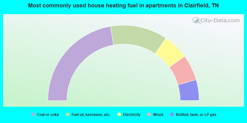
- 44.4%Coal or coke
- 24.4%Fuel oil, kerosene, etc.
- 11.1%Electricity
- 11.1%Wood
- 8.9%Bottled, tank, or LP gas
Clairfield compared to Tennessee state average:
- Median household income significantly below state average.
- Median house value significantly below state average.
- Black race population percentage significantly below state average.
- Hispanic race population percentage significantly below state average.
- Median age below state average.
- Foreign-born population percentage significantly below state average.
- Renting percentage significantly below state average.
- Length of stay since moving in significantly above state average.
- Number of rooms per house significantly below state average.
- House age significantly below state average.
- Number of college students significantly below state average.
- Percentage of population with a bachelor's degree or higher significantly below state average.
Clairfield on our top lists:
- #83 on the list of "Top 100 cities with longest commuting times"
- #37 on the list of "Top 101 counties with the smallest number of children under 18 without health insurance coverage in 2000"
- #61 on the list of "Top 101 counties with the smallest number of people without health insurance coverage in 2000"