Clifford, Kentucky
Submit your own pictures of this place and show them to the world
- OSM Map
- General Map
- Google Map
- MSN Map

| Males: 1,325 | |
| Females: 1,331 |
| Median resident age: | 35.5 years |
| Kentucky median age: | 35.9 years |
Zip code: 41230
| Clifford: | $39,150 |
| KY: | $59,341 |
Estimated per capita income in 2022: $18,773 (it was $10,506 in 2000)
Clifford CCD income, earnings, and wages data
Estimated median house or condo value in 2022: $99,933 (it was $38,900 in 2000)
| Clifford: | $99,933 |
| KY: | $196,300 |
Detailed information about poverty and poor residents in Clifford, KY


- 2,49298.3%White alone
- 210.8%Hispanic
- 110.4%Two or more races
- 80.3%American Indian alone
- 30.1%Other race alone
- 10.04%Asian alone

Races in Clifford detailed stats: ancestries, foreign born residents, place of birth
 Recent articles from our blog. Our writers, many of them Ph.D. graduates or candidates, create easy-to-read articles on a wide variety of topics.
Current Local Time: EST time zone
Land area: 76.1 square miles.
Population density: 35 people per square mile (very low).

| Clifford CCD: | 0.8% ($310) |
| Kentucky: | 0.8% ($610) |
Nearest city with pop. 50,000+: Huntington, WV  (30.1 miles , pop. 51,475).
Nearest city with pop. 200,000+: Fayette, KY (104.1 miles , pop. 260,512).
Nearest city with pop. 1,000,000+: Chicago, IL (379.1 miles , pop. 2,896,016).
Nearest cities:
), ), ), )Latitude: 37.99 N, Longitude: 82.59 W
Area code commonly used in this area: 606


| Here: | 5.7% |
| Kentucky: | 3.8% |

- Mining, quarrying, oil & gas extraction (15.2%)
- Health care (13.0%)
- Educational services (9.5%)
- Accommodation & food services (7.2%)
- Construction (6.7%)
- Food & beverage stores (6.1%)
- Public administration (4.7%)

- Mining, quarrying, oil & gas extraction (25.4%)
- Construction (11.8%)
- Administrative & support & waste management services (5.6%)
- Metal & metal products (5.4%)
- Agriculture, forestry, fishing & hunting (4.5%)
- Public administration (4.2%)
- Health care (4.0%)

- Health care (24.8%)
- Educational services (17.2%)
- Accommodation & food services (12.9%)
- Food & beverage stores (9.5%)
- Public administration (5.2%)
- Department & other general merchandise stores (3.4%)
- Social assistance (3.4%)

- Extraction workers (7.7%)
- Cashiers (7.1%)
- Driver/sales workers and truck drivers (4.7%)
- Cooks and food preparation workers (4.7%)
- Registered nurses (3.9%)
- Construction traders workers except carpenters, electricians, painters, plumbers, and construction laborers (3.9%)
- Electrical equipment mechanics and other installation, maintenance, and repair workers, including supervisors (3.7%)

- Extraction workers (13.6%)
- Driver/sales workers and truck drivers (8.2%)
- Construction traders workers except carpenters, electricians, painters, plumbers, and construction laborers (6.8%)
- Building and grounds cleaning and maintenance occupations (6.1%)
- Electrical equipment mechanics and other installation, maintenance, and repair workers, including supervisors (5.6%)
- Metal workers and plastic workers (5.6%)
- Sales representatives, services, wholesale and manufacturing (5.2%)

- Cashiers (13.2%)
- Other sales and related occupations, including supervisors (8.3%)
- Registered nurses (7.4%)
- Cooks and food preparation workers (7.1%)
- Nursing, psychiatric, and home health aides (5.8%)
- Preschool, kindergarten, elementary, and middle school teachers (5.5%)
- Secretaries and administrative assistants (5.5%)
Average climate in Clifford, Kentucky
Based on data reported by over 4,000 weather stations


Tornado activity:
Clifford-area historical tornado activity is significantly below Kentucky state average. It is 68% smaller than the overall U.S. average.
On 4/23/1968, a category F5 (max. wind speeds 261-318 mph) tornado 50.2 miles away from the Clifford place center killed 7 people and injured 93 people and caused between $500,000 and $5,000,000 in damages.
On 4/8/1965, a category F3 (max. wind speeds 158-206 mph) tornado 23.5 miles away from the place center injured 3 people and caused between $50,000 and $500,000 in damages.
Earthquake activity:
Clifford-area historical earthquake activity is significantly above Kentucky state average. It is 17% greater than the overall U.S. average.On 7/27/1980 at 18:52:21, a magnitude 5.2 (5.1 MB, 4.7 MS, 5.0 UK, 5.2 UK, Class: Moderate, Intensity: VI - VII) earthquake occurred 75.3 miles away from the city center
On 8/23/2011 at 17:51:04, a magnitude 5.8 (5.8 MW, Depth: 3.7 mi) earthquake occurred 253.6 miles away from the city center
On 8/9/2020 at 12:07:37, a magnitude 5.1 (5.1 MW, Depth: 4.7 mi) earthquake occurred 133.4 miles away from Clifford center
On 9/7/1988 at 02:28:09, a magnitude 4.6 (4.5 MB, 4.6 LG, Class: Light, Intensity: IV - V) earthquake occurred 71.1 miles away from the city center
On 11/2/2006 at 17:53:02, a magnitude 4.3 (4.3 MB, Depth: 0.6 mi) earthquake occurred 65.9 miles away from the city center
On 11/23/2006 at 10:42:57, a magnitude 4.3 (4.3 MB) earthquake occurred 66.9 miles away from Clifford center
Magnitude types: regional Lg-wave magnitude (LG), body-wave magnitude (MB), surface-wave magnitude (MS), moment magnitude (MW)
Natural disasters:
The number of natural disasters in Lawrence County (38) is a lot greater than the US average (15).Major Disasters (Presidential) Declared: 29
Emergencies Declared: 3
Causes of natural disasters: Floods: 27, Storms: 25, Tornadoes: 12, Mudslides: 11, Landslides: 8, Winter Storms: 7, Winds: 4, Fires: 2, Snowstorms: 2, Blizzard: 1, Freeze: 1, Hurricane: 1, Snow: 1, Snowfall: 1, Other: 1 (Note: some incidents may be assigned to more than one category).
Colleges/universities with over 2000 students nearest to Clifford:
- Big Sandy Community and Technical College (about 24 miles; Prestonsburg, KY; Full-time enrollment: 2,660)
- Marshall University (about 31 miles; Huntington, WV; FT enrollment: 11,450)
- Ashland Community and Technical College (about 34 miles; Ashland, KY; FT enrollment: 2,482)
- Morehead State University (about 48 miles; Morehead, KY; FT enrollment: 7,523)
- West Virginia State University (about 52 miles; Institute, WV; FT enrollment: 2,133)
- Shawnee State University (about 56 miles; Portsmouth, OH; FT enrollment: 4,160)
- Hazard Community and Technical College (about 62 miles; Hazard, KY; FT enrollment: 2,087)
Points of interest:
Notable locations in Clifford: Beech Farm (A), Cherryville Fire Station (B). Display/hide their locations on the map
Churches in Clifford include: Little Ethel Church (A), Mount Zion United Baptist Church (B), Northrup Church (C), Cherryville Missionary Baptist Church (D), Favored Church (E), Big Laurel Church (F), Richardson Missionary Baptist Church (G), Gallup-Chapman United Methodist Church (H), Richardson Chapel (I). Display/hide their locations on the map
Cemeteries: McClure Cemetery (1), Maynard Cemetery (2), Hardin Cemetery (3), Cartmill Cemetery (4), Vinson Cemetery (5), Little Cemetery (6), Hammond Cemetery (7). Display/hide their locations on the map
Streams, rivers, and creeks: Contrary Branch (A), Donithan Branch (B), Blackberry Branch (C), Blankenship Branch (D), Damron Branch (E), Ward Branch (F), Wooten Branch (G), Walker Fork (H), Van Branch (I). Display/hide their locations on the map
| This place: | 2.6 people |
| Kentucky: | 2.5 people |
| This place: | 73.6% |
| Whole state: | 66.9% |
| This place: | 4.8% |
| Whole state: | 6.4% |
Likely homosexual households (counted as self-reported same-sex unmarried-partner households)
- Lesbian couples: 0.0% of all households
- Gay men: 0.4% of all households
| This place: | 30.4% |
| Whole state: | 15.8% |
| This place: | 11.9% |
| Whole state: | 6.6% |
For population 15 years and over in Clifford:

- Never married: 19.9%
- Now married: 64.2%
- Separated: 2.0%
- Widowed: 7.8%
- Divorced: 8.1%
For population 25 years and over in Clifford:
- High school or higher: 50.6%
- Bachelor's degree or higher: 5.2%
- Graduate or professional degree: 2.0%
- Unemployed: 13.0%
- Mean travel time to work (commute): 41.6 minutes


| Here: | 16.0 |
| Kentucky average: | 13.8 |
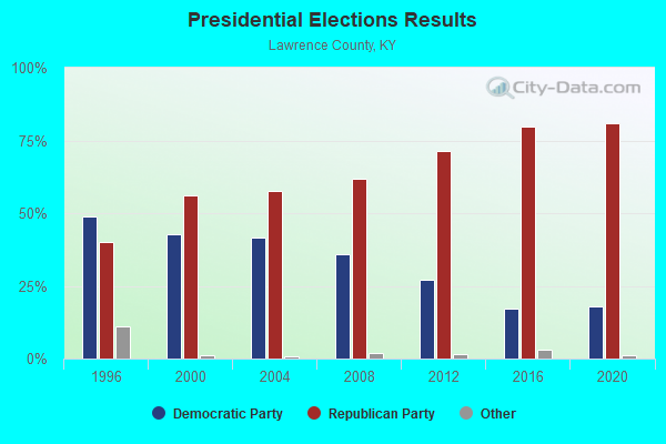
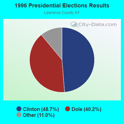
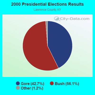
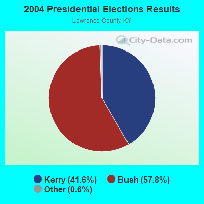
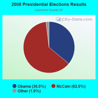
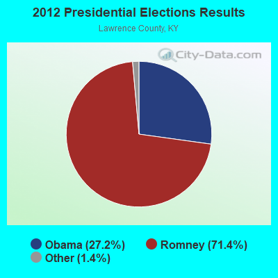
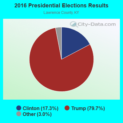
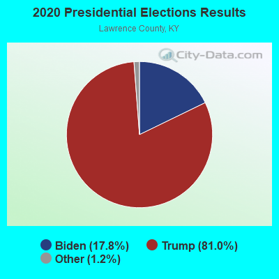
Graphs represent county-level data. Detailed 2008 Election Results
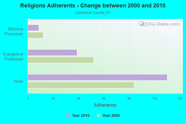
Religion statistics for Clifford, KY (based on Lawrence County data)
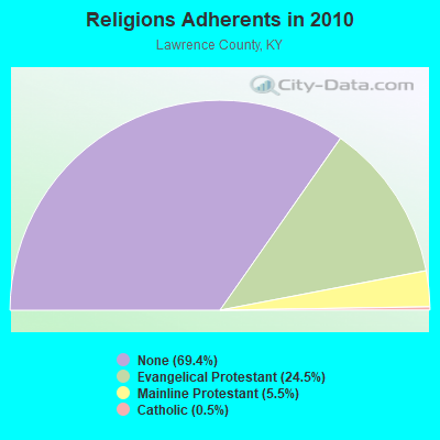
| Religion | Adherents | Congregations |
|---|---|---|
| Evangelical Protestant | 3,892 | 34 |
| Mainline Protestant | 870 | 8 |
| Catholic | 86 | 1 |
| Other | 1 | 1 |
| None | 11,011 | - |
Food Environment Statistics:
| Lawrence County: | 2.45 / 10,000 pop. |
| Kentucky: | 2.19 / 10,000 pop. |
| This county: | 0.61 / 10,000 pop. |
| Kentucky: | 0.25 / 10,000 pop. |
| Lawrence County: | 1.23 / 10,000 pop. |
| State: | 0.74 / 10,000 pop. |
| Lawrence County: | 7.97 / 10,000 pop. |
| Kentucky: | 4.36 / 10,000 pop. |
| Here: | 2.45 / 10,000 pop. |
| State: | 5.74 / 10,000 pop. |
| Here: | 11.6% |
| State: | 11.0% |
| Lawrence County: | 32.6% |
| State: | 30.0% |
| Here: | 21.6% |
| Kentucky: | 15.9% |
Strongest AM radio stations in Clifford:
- WKYH (600 AM; 5 kW; PAINTSVILLE, KY; Owner: HIGHLANDS BROADCASTING CORPORATION)
- WVHU (800 AM; 5 kW; HUNTINGTON, WV; Owner: CAPSTAR TX LIMITED PARTNERSHIP)
- WPRT (960 AM; 5 kW; PRESTONSBURG, KY; Owner: EAST KENTUCKY RADIO NETWORK, INC.)
- WDOC (1310 AM; 5 kW; PRESTONSBURG, KY)
- WRVC (930 AM; 5 kW; HUNTINGTON, WV; Owner: FIFTH AVENUE BROADCASTING COMPANY, INC.)
- WTVN (610 AM; 50 kW; COLUMBUS, OH; Owner: CITICASTERS LICENSES, L.P.)
- WTCR (1420 AM; 5 kW; KENOVA, WV; Owner: CAPSTAR TX LIMITED PARTNERSHIP)
- WHRD (1470 AM; 5 kW; HUNTINGTON, WV; Owner: CONCORD MEDIA GROUP, INC.)
- WLW (700 AM; 50 kW; CINCINNATI, OH; Owner: JACOR BROADCASTING CORPORATION)
- WGOH (1370 AM; 5 kW; GRAYSON, KY; Owner: CARTER COUNTY BROADCASTING CO., INC.)
- WCAW (680 AM; 10 kW; CHARLESTON, WV; Owner: WEST VIRGINIA RADIO CORPORATION OF CHARLESTON)
- WLSI (900 AM; 5 kW; PIKEVILLE, KY; Owner: EAST KENTUCKY BROADCASTING CORPORATION)
- WVOW (1290 AM; 5 kW; LOGAN, WV; Owner: LOGAN BROADCASTING CORPORATION)
Strongest FM radio stations in Clifford:
- WQHY (95.5 FM; PRESTONSBURG, KY; Owner: WDOC, INC.)
- WKLW-FM (94.7 FM; PAINTSVILLE, KY; Owner: B & G BROADCASTING, INC.)
- WZAQ (92.3 FM; LOUISA, KY; Owner: LOUISA COMMUNICATIONS, INC.)
- WSIP-FM (98.9 FM; PAINTSVILLE, KY; Owner: SIP BROADCASTING, INC.)
- WFGH (90.7 FM; FORT GAY, WV; Owner: WAYNE COUNTY BOARD OF EDUCATION)
- WKLC-FM (105.1 FM; ST. ALBANS, WV; Owner: WKLC, INC.)
- WDGG (93.7 FM; ASHLAND, KY; Owner: FIFTH AVENUE B/CASTING COMPANY, INC.)
- WXLR (104.9 FM; HAROLD, KY; Owner: ADAM D GEARHEART)
- WVWV (89.9 FM; HUNTINGTON, WV; Owner: WEST VIRGINIA EDUCATIONAL BROADCASTING AUTHORITY)
- WAMX (106.3 FM; MILTON, WV; Owner: CAPSTAR TX LIMITED PARTNERSHIP)
- WVKM (106.7 FM; MATEWAN, WV; Owner: THREE STATES BROADCASTING CO., INC.)
- WVOW-FM (101.9 FM; LOGAN, WV; Owner: LOGAN BROADCASTING CORP.)
- WPKE-FM (103.1 FM; COAL RUN, KY; Owner: EAST KENTUCKY BROADCASTING CORP.)
- WDHR (93.1 FM; PIKEVILLE, KY; Owner: EAST KENTUCKY BROADCASTING CORP.)
- WKEE-FM (100.5 FM; HUNTINGTON, WV; Owner: CAPSTAR TX LIMITED PARTNERSHIP)
- WBKS (107.1 FM; IRONTON, OH; Owner: CAPSTAR TX LIMITED PARTNERSHIP)
- WXCC (96.5 FM; WILLIAMSON, WV; Owner: EAST KENTUCKY RADIO NETWORK, INC.)
- WMDJ-FM (100.1 FM; ALLEN, KY; Owner: FLOYD COUNTY BROADCASTING CO., INC.)
- WTCR-FM (103.3 FM; HUNTINGTON, WV; Owner: CAPSTAR TX LIMITED PARTNERSHIP)
- WXKZ-FM (105.3 FM; PRESTONSBURG, KY; Owner: ADAM GEARHEART D/B/A WXLR-FM)
TV broadcast stations around Clifford:
- WVAH-TV (Channel 11; CHARLESTON, WV; Owner: WVAH LICENSEE, LLC)
- WPBY-TV (Channel 33; HUNTINGTON, WV; Owner: WEST VIRGINIA EDUCATIONAL BROADCASTING AUTHORITY)
- WSAZ-TV (Channel 3; HUNTINGTON, WV; Owner: EMMIS TELEVISION LICENSE CORPORATION)
- WCHS-TV (Channel 8; CHARLESTON, WV; Owner: WCHS LICENSEE, LLC)
- WOWK-TV (Channel 13; HUNTINGTON, WV; Owner: WEST VIRGINIA MEDIA HOLDINGS, LLC)
- W14CU (Channel 14; HUNTINGTON, WV; Owner: VENTANA TELEVISION, INC.)
- W10AR (Channel 10; LOUISA, KY; Owner: KENTUCKY AUTHORITY FOR EDUCATIONAL TV)

- 48.9%Electricity
- 30.2%Utility gas
- 9.7%Bottled, tank, or LP gas
- 4.0%Fuel oil, kerosene, etc.
- 3.8%Wood
- 3.4%Coal or coke

- 57.0%Electricity
- 11.9%Bottled, tank, or LP gas
- 8.1%No fuel used
- 5.9%Utility gas
- 5.2%Fuel oil, kerosene, etc.
- 4.4%Wood
- 3.7%Coal or coke
- 3.7%Other fuel
Clifford compared to Kentucky state average:
- Median household income below state average.
- Median house value below state average.
- Black race population percentage significantly below state average.
- Hispanic race population percentage significantly below state average.
- Median age below state average.
- Foreign-born population percentage significantly below state average.
- Renting percentage below state average.
- Length of stay since moving in significantly above state average.
- Number of rooms per house significantly below state average.
- House age significantly below state average.
- Percentage of population with a bachelor's degree or higher significantly below state average.