Cody, Wyoming

Cody: Buggling at Sinrise www.cherishedphotoimages.com
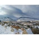
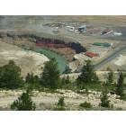
Cody: Cody, WY Looking West to Buffalo Bill Dam
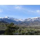
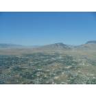
Cody: Mountains Near Cody
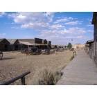
Cody: TRAIL TOWN
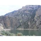
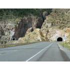
Cody: Wapiti Valley, East of Cody
Cody: View of the Cody Rodeo and the Shoshone River
Cody: Leaving Cody.
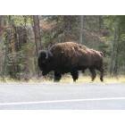
Cody: Bison
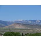
Cody: Mountains Near Cody
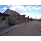
Cody: TRAIL TOWN
Cody: Cody from Air
- see
28
more - add
your
Submit your own pictures of this city and show them to the world
- OSM Map
- General Map
- Google Map
- MSN Map
Population change since 2000: +15.7%
| Males: 5,336 | |
| Females: 4,888 |
| Median resident age: | 44.8 years |
| Wyoming median age: | 39.1 years |
Zip codes: 82414.
| Cody: | $65,471 |
| WY: | $70,042 |
Estimated per capita income in 2022: $37,074 (it was $17,813 in 2000)
Cody city income, earnings, and wages data
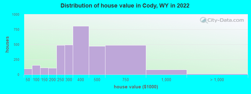
Estimated median house or condo value in 2022: $326,956 (it was $100,100 in 2000)
| Cody: | $326,956 |
| WY: | $292,300 |
Mean prices in 2022: all housing units: $376,468; detached houses: $410,134; townhouses or other attached units: $397,688; in 2-unit structures: $167,652; in 5-or-more-unit structures: $829,443; mobile homes: $54,085
Median gross rent in 2022: $924.
(8.2% for White Non-Hispanic residents, 30.9% for Hispanic or Latino residents, 100.0% for American Indian residents, 22.7% for two or more races residents)
Detailed information about poverty and poor residents in Cody, WY


Compare current foreclosures near Cody, WY:
| Photo | Address | Area | Beds / Baths | Price | Details |
|---|---|---|---|---|---|

|
#1
Cougar Ave
Cody, WY 82414
|
- sq. feet
|
- baths - beds |
show details | |

|
#2
Road 3dx
Cody, WY 82414
|
- sq. feet
|
- baths - beds |
show details | |

|
#3
Belfry Hwy Lot 12
Cody, WY 82414
|
- sq. feet
|
- baths - beds |
show details | |

|
#4
W Yellowstone Ave
Cody, WY 82414
|
- sq. feet
|
- baths - beds |
show details | |

|
#5
Horizon Ave
Cody, WY 82414
|
- sq. feet
|
- baths - beds |
show details | |

|
#6
Moonlite Dr
Cody, WY 82414
|
- sq. feet
|
- baths - beds |
show details | |

|
#7
23rd St
Cody, WY 82414
|
- sq. feet
|
- baths - beds |
show details | |

|
#8
29th St
Cody, WY 82414
|
- sq. feet
|
- baths - beds |
show details | |

|
Check over 1 million property listings on Foreclosure.com!
|
browse all offers | |||


- 8,90787.8%White alone
- 5955.9%Hispanic
- 5035.0%Two or more races
- 1071.1%Other race alone
- 520.5%Black alone
- 130.1%American Indian alone
- 110.1%Asian alone
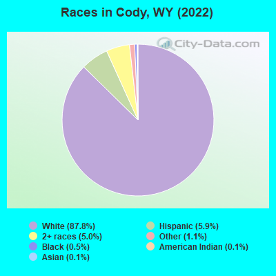
Races in Cody detailed stats: ancestries, foreign born residents, place of birth
According to our research of Wyoming and other state lists, there were 15 registered sex offenders living in Cody, Wyoming as of June 16, 2024.
The ratio of all residents to sex offenders in Cody is 654 to 1.
The ratio of registered sex offenders to all residents in this city is much lower than the state average.
Type |
2009 |
2010 |
2011 |
2012 |
2013 |
2014 |
2015 |
2016 |
2017 |
2018 |
2019 |
2020 |
2021 |
2022 |
|---|---|---|---|---|---|---|---|---|---|---|---|---|---|---|
| Murders (per 100,000) | 0 (0.0) | 0 (0.0) | 0 (0.0) | 1 (10.2) | 0 (0.0) | 0 (0.0) | 0 (0.0) | 0 (0.0) | 0 (0.0) | 0 (0.0) | 0 (0.0) | 0 (0.0) | 1 (10.1) | 0 (0.0) |
| Rapes (per 100,000) | 6 (64.1) | 1 (10.5) | 4 (41.7) | 1 (10.2) | 0 (0.0) | 4 (40.4) | 1 (10.2) | 2 (20.3) | 1 (10.1) | 4 (40.3) | 8 (81.1) | 5 (50.9) | 5 (50.6) | 8 (77.8) |
| Robberies (per 100,000) | 0 (0.0) | 1 (10.5) | 0 (0.0) | 1 (10.2) | 2 (20.5) | 0 (0.0) | 0 (0.0) | 0 (0.0) | 1 (10.1) | 0 (0.0) | 1 (10.1) | 0 (0.0) | 0 (0.0) | 1 (9.7) |
| Assaults (per 100,000) | 17 (181.7) | 12 (126.1) | 20 (208.4) | 14 (143.0) | 12 (123.3) | 11 (111.0) | 10 (102.2) | 9 (91.4) | 9 (91.0) | 19 (191.2) | 6 (60.8) | 17 (173.2) | 11 (111.4) | 13 (126.4) |
| Burglaries (per 100,000) | 32 (342.0) | 30 (315.1) | 43 (448.1) | 32 (326.8) | 33 (338.9) | 32 (323.0) | 51 (521.0) | 35 (355.6) | 26 (263.0) | 15 (151.0) | 11 (111.5) | 26 (264.9) | 13 (131.6) | 17 (165.4) |
| Thefts (per 100,000) | 201 (2,148) | 239 (2,511) | 219 (2,282) | 148 (1,511) | 168 (1,726) | 152 (1,534) | 135 (1,379) | 181 (1,839) | 120 (1,214) | 125 (1,258) | 95 (963.0) | 92 (937.2) | 93 (941.5) | 69 (671.1) |
| Auto thefts (per 100,000) | 7 (74.8) | 2 (21.0) | 4 (41.7) | 6 (61.3) | 3 (30.8) | 4 (40.4) | 3 (30.6) | 5 (50.8) | 3 (30.3) | 6 (60.4) | 4 (40.5) | 5 (50.9) | 2 (20.2) | 4 (38.9) |
| Arson (per 100,000) | 3 (32.1) | 2 (21.0) | 3 (31.3) | 2 (20.4) | 1 (10.3) | 1 (10.1) | 1 (10.2) | 1 (10.2) | 0 (0.0) | 0 (0.0) | 2 (20.3) | 0 (0.0) | 1 (10.1) | 0 (0.0) |
| City-Data.com crime index | 203.5 | 160.9 | 201.0 | 148.5 | 126.0 | 141.7 | 122.7 | 137.1 | 98.7 | 136.2 | 129.7 | 135.5 | 131.5 | 132.0 |
The City-Data.com crime index weighs serious crimes and violent crimes more heavily. Higher means more crime, U.S. average is 246.1. It adjusts for the number of visitors and daily workers commuting into cities.
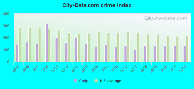
Crime rate in Cody detailed stats: murders, rapes, robberies, assaults, burglaries, thefts, arson
Full-time law enforcement employees in 2021, including police officers: 26 (23 officers - 22 male; 1 female).
| Officers per 1,000 residents here: | 2.33 |
| Wyoming average: | 2.78 |
 Recent articles from our blog. Our writers, many of them Ph.D. graduates or candidates, create easy-to-read articles on a wide variety of topics.


Latest news from Cody, WY collected exclusively by city-data.com from local newspapers, TV, and radio stations
Ancestries: German (31.9%), American (11.7%), Irish (6.7%), European (5.2%), English (5.2%), Swedish (4.0%).
Current Local Time: MST time zone
Elevation: 5088 feet
Land area: 9.28 square miles.
Population density: 1,102 people per square mile (low).
278 residents are foreign born (1.7% Latin America, 0.6% Europe).
| This city: | 2.7% |
| Wyoming: | 3.4% |
Median real estate property taxes paid for housing units with mortgages in 2022: $1,813 (0.5%)
Median real estate property taxes paid for housing units with no mortgage in 2022: $1,954 (0.6%)
Nearest city with pop. 50,000+: Billings, MT  (91.0 miles , pop. 89,847).
Nearest city with pop. 200,000+: West Adams, CO (383.0 miles , pop. 259,628).
Nearest city with pop. 1,000,000+: Phoenix, AZ (777.4 miles , pop. 1,321,045).
Nearest cities:
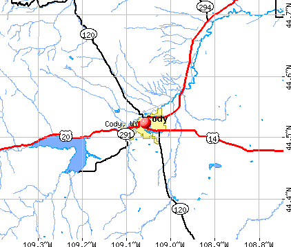
), ), Latitude: 44.52 N, Longitude: 109.06 W
Daytime population change due to commuting: +2,229 (+22.0%)
Workers who live and work in this city: 4,383 (84.5%)
Area code: 307

Cody tourist attractions:
- Chamberlin Inn, Cody, WY - Hotel
- Buffalo Bill Historical Center, Cody, WY
- Cedar Mountain Trail Rides, Cody, WY
- Cody Night Rodeo, Cody, WY
- Dan Miller's Cowboy Music Revue, Cody, WY
- Old West Miniature Village and Museum
- Red Canyon Wild Mustang Tour
- Teton National Forest
- The Cody Cattle Company
- Whitney Gallery
- Old Trail Town, Cody, WY
Cody, Wyoming accommodation & food services, waste management - Economy and Business Data
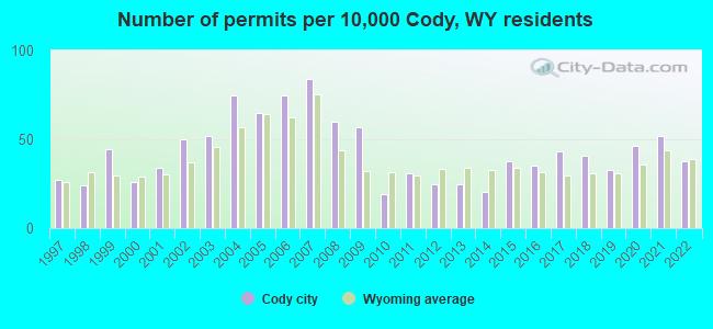
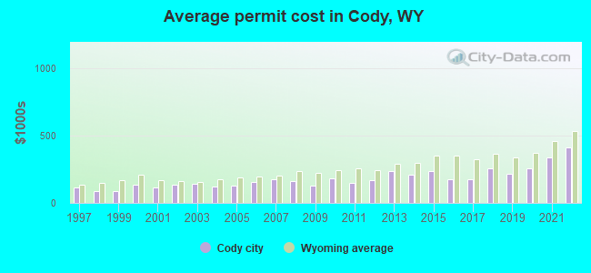
Single-family new house construction building permits:
- 2022: 33 buildings, average cost: $410,500
- 2021: 46 buildings, average cost: $341,000
- 2020: 41 buildings, average cost: $254,200
- 2019: 29 buildings, average cost: $219,200
- 2018: 36 buildings, average cost: $254,700
- 2017: 38 buildings, average cost: $176,200
- 2016: 31 buildings, average cost: $178,700
- 2015: 33 buildings, average cost: $233,800
- 2014: 18 buildings, average cost: $210,700
- 2013: 22 buildings, average cost: $236,900
- 2012: 22 buildings, average cost: $166,900
- 2011: 27 buildings, average cost: $151,700
- 2010: 17 buildings, average cost: $184,800
- 2009: 50 buildings, average cost: $126,300
- 2008: 53 buildings, average cost: $161,800
- 2007: 74 buildings, average cost: $173,600
- 2006: 66 buildings, average cost: $156,600
- 2005: 57 buildings, average cost: $126,900
- 2004: 66 buildings, average cost: $124,000
- 2003: 46 buildings, average cost: $141,400
- 2002: 44 buildings, average cost: $134,900
- 2001: 30 buildings, average cost: $117,300
- 2000: 23 buildings, average cost: $134,200
- 1999: 39 buildings, average cost: $87,500
- 1998: 21 buildings, average cost: $89,500
- 1997: 24 buildings, average cost: $113,700
| Here: | 2.7% |
| Wyoming: | 2.5% |
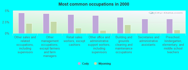
- Other sales and related occupations, including supervisors (4.5%)
- Other management occupations, except farmers and farm managers (4.4%)
- Retail sales workers, except cashiers (4.2%)
- Other office and administrative support workers, including supervisors (4.0%)
- Building and grounds cleaning and maintenance occupations (3.6%)
- Secretaries and administrative assistants (3.2%)
- Preschool, kindergarten, elementary, and middle school teachers (3.2%)
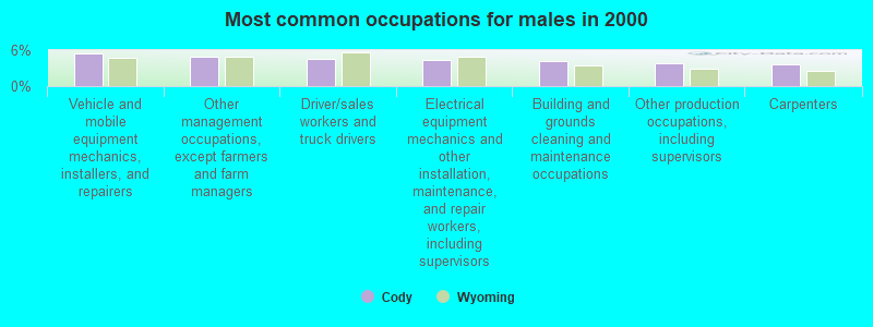
- Vehicle and mobile equipment mechanics, installers, and repairers (5.4%)
- Other management occupations, except farmers and farm managers (4.9%)
- Driver/sales workers and truck drivers (4.6%)
- Electrical equipment mechanics and other installation, maintenance, and repair workers, including supervisors (4.4%)
- Building and grounds cleaning and maintenance occupations (4.1%)
- Other production occupations, including supervisors (3.8%)
- Carpenters (3.7%)
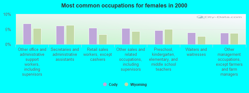
- Other office and administrative support workers, including supervisors (6.9%)
- Secretaries and administrative assistants (6.2%)
- Retail sales workers, except cashiers (5.5%)
- Other sales and related occupations, including supervisors (5.4%)
- Preschool, kindergarten, elementary, and middle school teachers (4.7%)
- Waiters and waitresses (3.9%)
- Other management occupations, except farmers and farm managers (3.8%)
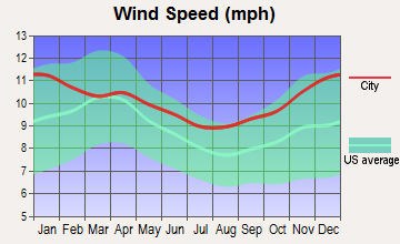
Average climate in Cody, Wyoming
Based on data reported by over 4,000 weather stations


|
|


(lower is better)
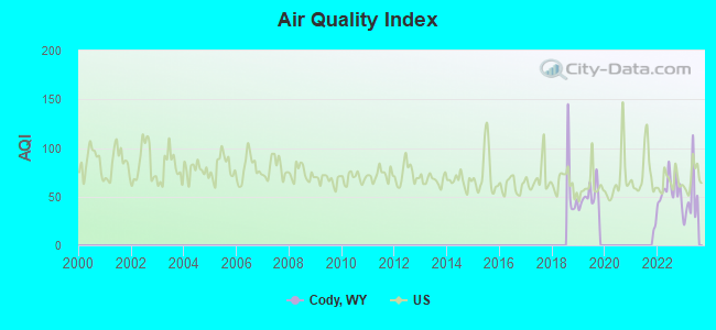
Air Quality Index (AQI) level in 2023 was 46.5. This is significantly better than average.
| City: | 46.5 |
| U.S.: | 72.6 |
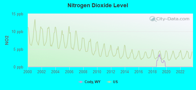
Nitrogen Dioxide (NO2) [ppb] level in 2019 was 1.86. This is significantly better than average. Closest monitor was 2.0 miles away from the city center.
| City: | 1.86 |
| U.S.: | 5.11 |
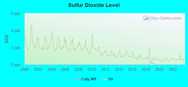
Sulfur Dioxide (SO2) [ppb] level in 2019 was 0.0531. This is significantly better than average. Closest monitor was 2.0 miles away from the city center.
| City: | 0.0531 |
| U.S.: | 1.5147 |
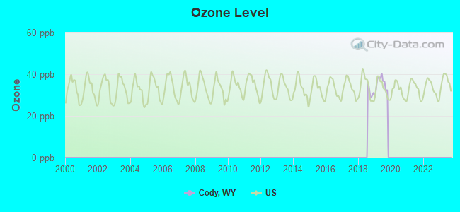
Ozone [ppb] level in 2019 was 35.5. This is about average. Closest monitor was 2.0 miles away from the city center.
| City: | 35.5 |
| U.S.: | 33.3 |
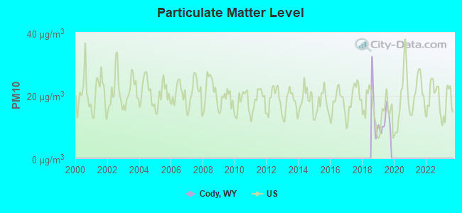
Particulate Matter (PM10) [µg/m3] level in 2019 was 11.4. This is significantly better than average. Closest monitor was 0.6 miles away from the city center.
| City: | 11.4 |
| U.S.: | 19.2 |
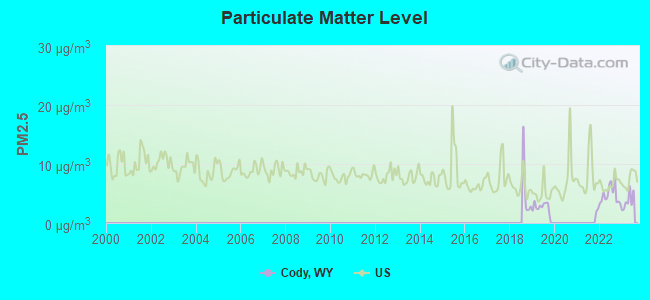
Particulate Matter (PM2.5) [µg/m3] level in 2023 was 3.76. This is significantly better than average. Closest monitor was 0.6 miles away from the city center.
| City: | 3.76 |
| U.S.: | 8.11 |
Earthquake activity:
Cody-area historical earthquake activity is significantly above Wyoming state average. It is 1119% greater than the overall U.S. average.On 8/18/1959 at 06:37:13, a magnitude 7.7 (7.7 UK, Class: Major, Intensity: VIII - XII) earthquake occurred 78.8 miles away from Cody center, causing $26,000,000 total damage
On 10/28/1983 at 14:06:06, a magnitude 7.3 (6.2 MB, 7.3 MS, 7.0 MW) earthquake occurred 236.9 miles away from Cody center, causing 2 deaths (2 shaking deaths) and 3 injuries, causing $15,000,000 total damage
On 6/30/1975 at 18:54:13, a magnitude 6.1 (5.6 MB, 5.9 MS, 6.1 UK, 6.1 ML, Class: Strong, Intensity: VII - IX) earthquake occurred 83.4 miles away from the city center
On 3/31/2020 at 23:52:30, a magnitude 6.5 (6.5 MW, Depth: 7.5 mi) earthquake occurred 299.0 miles away from the city center
On 2/3/1994 at 09:05:04, a magnitude 5.8 (5.4 MB, 5.5 MS, 5.8 MW, 5.8 ML, Depth: 4.9 mi, Class: Moderate, Intensity: VI - VII) earthquake occurred 154.0 miles away from Cody center
On 3/28/1975 at 02:31:05, a magnitude 6.2 (6.1 MB, 6.0 MS, 6.2 ML) earthquake occurred 244.5 miles away from Cody center
Magnitude types: body-wave magnitude (MB), local magnitude (ML), surface-wave magnitude (MS), moment magnitude (MW)
Natural disasters:
The number of natural disasters in Park County (3) is a lot smaller than the US average (15).Major Disasters (Presidential) Declared: 1
Causes of natural disasters: Floods: 2, Mudslide: 1, Storm: 1, Other: 1 (Note: some incidents may be assigned to more than one category).

Hospitals and medical centers in Cody:
Airports and heliports located in Cody:
- Yellowstone Regional Airport (COD) (Runways: 1, Commercial Ops: 42, Air Taxi Ops: 1,616, Itinerant Ops: 17,808, Local Ops: 36,192, Military Ops: 30)
- Bar Flying E Airport (2WY8) (Runways: 1)
- Luckinbill Airstrip Airport (WY06) (Runways: 1)
- West Park Hospital Heliport (WY62)
Colleges/universities with over 2000 students nearest to Cody:
- Montana State University-Billings (about 92 miles; Billings, MT; Full-time enrollment: 4,319)
- Sheridan College (about 106 miles; Sheridan, WY; FT enrollment: 2,070)
- Montana State University (about 126 miles; Bozeman, MT; FT enrollment: 12,942)
- Brigham Young University-Idaho (about 144 miles; Rexburg, ID; FT enrollment: 30,522)
- Casper College (about 180 miles; Casper, WY; FT enrollment: 2,770)
- Western Wyoming Community College (about 204 miles; Rock Springs, WY; FT enrollment: 2,086)
- Idaho State University (about 204 miles; Pocatello, ID; FT enrollment: 10,350)
Public high school in Cody:
- CODY HIGH SCHOOL (Students: 742, Location: 1225 10TH ST, Grades: 9-12)
Private high school in Cody:
- PARK CHRISTIAN SCHOOLS (Students: 13, Location: 801 GERRANS AVE, Grades: KG-12)
Public elementary/middle schools in Cody:
- CODY MIDDLE SCHOOL (Students: 493, Location: 2901 COUGAR AVE., Grades: 6-8)
- EASTSIDE ELEMENTARY (Students: 357, Location: 801 17TH ST, Grades: KG-5)
- SUNSET ELEMENTARY (Students: 282, Location: 3101 EAST SHERIDAN AVE., Grades: KG-5)
- GLENN LIVINGSTON ELEMENTARY (Students: 269, Location: 2001 12TH ST, Grades: KG-5)
- VALLEY ELEMENTARY (Students: 4, Location: S. FORK HIGHWAY, Grades: KG-5)
- WAPITI ELEMENTARY (Location: 3167 N. FORK HIGHWAY, Grades: KG-5)
Library in Cody:
- PARK COUNTY LIBRARY SYSTEM (Operating income: $1,143,905; Location: 1057 SHERIDAN AVE; 143,105 books; 10 e-books; 7,564 audio materials; 6,097 video materials; 1 local licensed databases; 39 state licensed databases; 1 other licensed databases; 185 print serial subscriptions; 2 electronic serial subscriptions)
Points of interest:
Notable locations in Cody: Shoshone National Forest Wapiti - Clarks Fork - Greybull Ranger District Fire Engine Crew (A), Park County Fire Protection District 2 Station 1 Cody Headquarters (B), West Park Hospital Emergency Medical Services (C). Display/hide their locations on the map
Shopping Center: Eastgate Shopping Center (1). Display/hide its location on the map
Cemetery: Riverside Cemetery (1). Display/hide its location on the map
Reservoirs: Markham Lake (A), Cody Municipal Reservoir (B), Beck Lake (C), City Reservoir (D). Display/hide their locations on the map
Tourist attractions: Museum Buffalo Bill Historical Center (720 Sheridan Avenue) (1), Tecumseh's Frontier Trading Post (Museums; 140 West Yellowstone Avenue) (2), Jackson- Harry A (Museums; 35 Wild Horse Road) (3), Whitney Gallery of Western Art (Museums; 720 Sheridan Avenue) (4), Buffalo Bill Historical Center - Whitney Gallery of Western Art- Museum Education Depart (720 Sheridan Avenue) (5), Buffalo Bill Dam Visitor Center (4808 North Fork Highway) (6), Monster Lake (29 Nielson Road) (7), A B C Trading Post (610 Yellowstone Avenue) (8), Robin's Nest Bed & Breakfast (Recreational Trips & Guides; 1508 Alger Avenue) (9). Display/hide their approximate locations on the map
Hotels: Green Creek Inn & RV Park (2908 North Fork Highway) (1), Elephant Head Lodge (1171 North Fork Highway) (2), Sunrise Motor Inn LLC (1407 8th Street) (3), Trail Shop & Inn (7 Road 6Bu) (4), Irma Hotel (1192 Sheridan Avenue) (5), Super 8 Cody WY (730 Yellowstone Road) (6), Sleeping Giant Ski Resort (East Entrance To Yellowst) (7), Friendship Inns International (1919 17th Street) (8), Frontier Motel (1801 Mountain View Drive) (9). Display/hide their approximate locations on the map
Courts: Park County Government - District Court Judge (1002 Sheridan Avenue) (1), Park County Government - District Court Clerk (1002 Sheridan Avenue) (2), Park County Government - County Court Clerk- Circuit Court Park County (1002 Sheridan Avenue) (3), Park - Cody- District Court Judge (1002 Sheridan Avenue) (4), Park - Cody- District Court Clerk (1002 Sheridan Avenue) (5). Display/hide their approximate locations on the map
Birthplace of: Jackson Pollock - (1912-1956), abstract artist, Craig L. Thomas - Politician, Kirk Fernandez - Businessman, Larry Echo Hawk - Attorney and legal scholar, Nancy D. Freudenthal - Judge, John Wendling - Football player.
Drinking water stations with addresses in Cody and their reported violations in the past:
NORTHWEST RURAL WATER DISTRICT (Population served: 5,500, Purch surface water):Past monitoring violations:JUBY`S MOBILE HOME PARK (Population served: 300, Purch surface water):
- One routine major monitoring violation
Past health violations:PAHASKA TEPEE RESORT (Population served: 205, Groundwater under infl of surface water):Past monitoring violations:
- MCL, Monthly (TCR) - In SEP-2011, Contaminant: Coliform. Follow-up actions: St Compliance achieved (OCT-04-2011), St Public Notif requested (OCT-06-2011), St Violation/Reminder Notice (OCT-06-2011), St Public Notif received (OCT-25-2011), Fed FAO issued (SEP-05-2012)
- 4 routine major monitoring violations
Past monitoring violations:SLEEPING GIANT SKI AREA (Population served: 200, Groundwater):
- Monthly Turbidity Exceed (Enhanced SWTR) - In MAY-2006, Contaminant: IESWTR. Follow-up actions: St Violation/Reminder Notice (JUN-27-2006), Fed Compliance achieved (DEC-04-2009)
- One regular monitoring violation
Past monitoring violations:SHOSHONE NF-WAPITI CG & RANGER STATION (Population served: 200, Groundwater):
- 3 routine major monitoring violations
Past health violations:SHOSHONE NF-FOX CREEK CG (Population served: 120, Groundwater):
- MCL, Monthly (TCR) - In AUG-2009, Contaminant: Coliform. Follow-up actions: St Compliance achieved (MAY-05-2010)
Past monitoring violations:NORTHWEST COLLEGE FIELD STATION (Population served: 80, Surface water):
- One routine major monitoring violation
Past monitoring violations:SHOSHONE NF BEARTOOTH LAKE CG (Population served: 80, Groundwater):
- Monthly Turbidity Exceed (Enhanced SWTR) - In MAY-2007, Contaminant: IESWTR. Follow-up actions: St Violation/Reminder Notice (JUN-26-2007), St Compliance achieved (JUN-30-2007)
- One routine major monitoring violation
Past monitoring violations:
- 2 routine major monitoring violations
Drinking water stations with addresses in Cody that have no violations reported:
- CODY, CITY OF (Population served: 8,749, Primary Water Source Type: Purch surface water)
- SHOSHONE NF THREE MI CG MIDDLE (Population served: 50, Primary Water Source Type: Groundwater)
- SHOSHONE NF EAGLE CREEK EAST (Population served: 50, Primary Water Source Type: Groundwater)
- SHOSHONE NF EAGLE CREEK WEST (Population served: 50, Primary Water Source Type: Groundwater)
- BUFFALO BILL ST PK NORTH FORK (Population served: 40, Primary Water Source Type: Groundwater)
- RIMROCK RANCH (Population served: 40, Primary Water Source Type: Groundwater)
- BUFFALO BILL ST PK NO.SHORE BA (Population served: 25, Primary Water Source Type: Groundwater)
- BLM - FIVE SPRINGS CAMPGROUND (Population served: 25, Primary Water Source Type: Groundwater)
- SHOSHONE MUNICIPAL PIPELINE (Population served: 25, Primary Water Source Type: Surface water)
| This city: | 2.2 people |
| Wyoming: | 2.4 people |
| This city: | 58.5% |
| Whole state: | 64.6% |
| This city: | 6.5% |
| Whole state: | 7.1% |
Likely homosexual households (counted as self-reported same-sex unmarried-partner households)
- Lesbian couples: 0.4% of all households
- Gay men: 0.3% of all households
People in group quarters in Cody in 2010:
- 78 people in nursing facilities/skilled-nursing facilities
- 55 people in local jails and other municipal confinement facilities
- 11 people in group homes intended for adults
People in group quarters in Cody in 2000:
- 97 people in wards in general hospitals for patients who have no usual home elsewhere
- 74 people in other noninstitutional group quarters
- 42 people in local jails and other confinement facilities (including police lockups)
- 9 people in hospitals or wards for drug/alcohol abuse
- 7 people in unknown juvenile institutions
Banks with branches in Cody (2011 data):
- First Bank of Wyoming: Downtown Cody Branch at 1426 Sheridan Avenue, branch established on 2010/02/22; Cody Branch at 1507 8th Street, branch established on 1997/03/17. Info updated 2011/08/08: Bank assets: $391.2 mil, Deposits: $288.5 mil, headquarters in Powell, WY, positive income, 4 total offices, Holding Company: Glacier Bancorp, Inc.
- Wells Fargo Bank, National Association: Sheridan Albertsons Branch at 1825 17th Street, branch established on 1995/07/01; Shoshone Branch at 1401 Sheridan Avenue, branch established on 1901/01/01. Info updated 2011/04/05: Bank assets: $1,161,490.0 mil, Deposits: $905,653.0 mil, headquarters in Sioux Falls, SD, positive income, 6395 total offices, Holding Company: Wells Fargo & Company
- Pinnacle Bank - Wyoming: Cody - Yellowstone Branch at 627 Yellowstone, branch established on 1998/12/31; 1702 17th Street Branch at 1702 Sheridan Avenue, branch established on 1979/05/14. Info updated 2006/11/03: Bank assets: $597.7 mil, Deposits: $524.1 mil, headquarters in Torrington, WY, positive income, Agricultural Specialization, 14 total offices, Holding Company: Pinnacle Bancorp, Inc.
- U.S. Bank National Association: Cody Branch at 1132 Beck Avenue, branch established on 1992/10/05. Info updated 2012/01/30: Bank assets: $330,470.8 mil, Deposits: $236,091.5 mil, headquarters in Cincinnati, OH, positive income, 3121 total offices, Holding Company: U.S. Bancorp
- Big Horn Federal Savings Bank: 1701 Stampede Avenue Branch at 1701 Stampede Avenue, branch established on 1935/01/01. Info updated 2011/07/21: Bank assets: $204.4 mil, Deposits: $178.9 mil, headquarters in Greybull, WY, positive income, 6 total offices
- Bank of the West: Cody Branch at 1130 Sheridan Avenue, branch established on 1959/07/25. Info updated 2009/11/16: Bank assets: $62,408.3 mil, Deposits: $43,995.2 mil, headquarters in San Francisco, CA, positive income, 647 total offices, Holding Company: Bnp Paribas
For population 15 years and over in Cody:
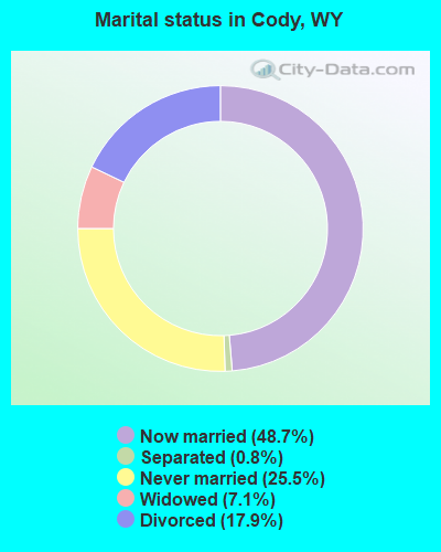
- Never married: 25.5%
- Now married: 48.7%
- Separated: 0.8%
- Widowed: 7.1%
- Divorced: 17.9%
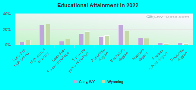
For population 25 years and over in Cody:
- High school or higher: 97.0%
- Bachelor's degree or higher: 40.5%
- Graduate or professional degree: 13.7%
- Unemployed: 5.2%
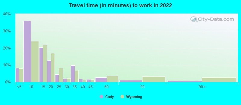
- Mean travel time to work (commute): 12.0 minutes
| Here: | 9.8 |
| Wyoming average: | 10.2 |
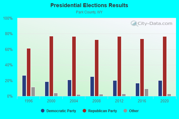
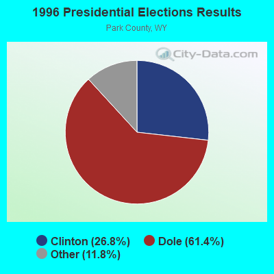
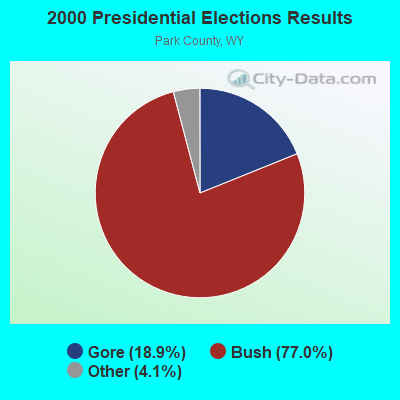
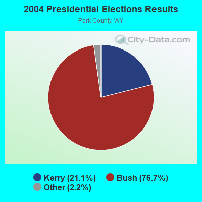
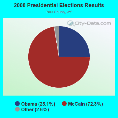

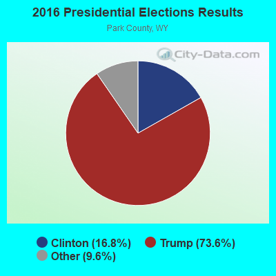
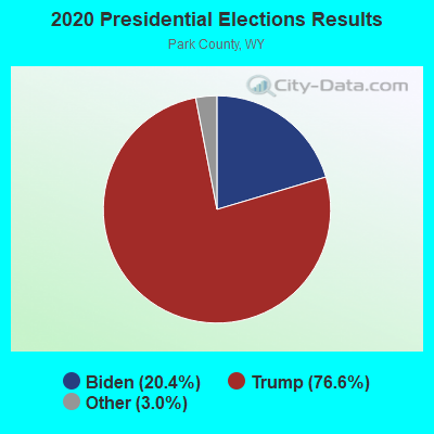
Graphs represent county-level data. Detailed 2008 Election Results
Religion statistics for Cody, WY (based on Park County data)
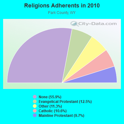
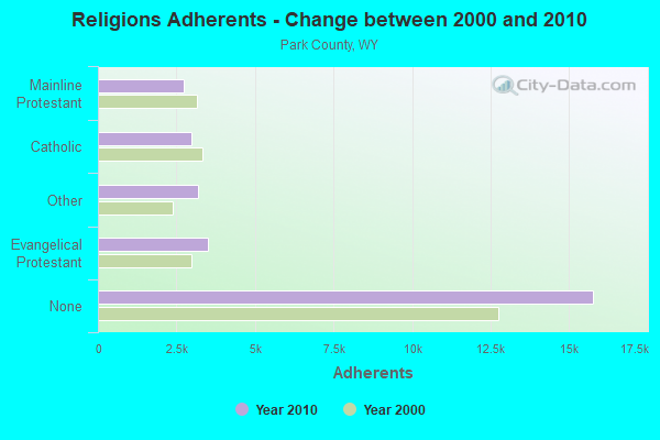
| Religion | Adherents | Congregations |
|---|---|---|
| Evangelical Protestant | 3,518 | 37 |
| Other | 3,196 | 13 |
| Catholic | 2,985 | 4 |
| Mainline Protestant | 2,732 | 9 |
| None | 15,774 | - |
Food Environment Statistics:
| Park County: | 1.84 / 10,000 pop. |
| State: | 2.10 / 10,000 pop. |
| Here: | 0.37 / 10,000 pop. |
| Wyoming: | 0.27 / 10,000 pop. |
| Park County: | 0.74 / 10,000 pop. |
| Wyoming: | 0.65 / 10,000 pop. |
| Park County: | 6.99 / 10,000 pop. |
| Wyoming: | 5.36 / 10,000 pop. |
| Park County: | 15.82 / 10,000 pop. |
| State: | 10.08 / 10,000 pop. |
| Park County: | 6.7% |
| State: | 7.1% |
| Park County: | 22.0% |
| Wyoming: | 24.4% |
Health and Nutrition:
| This city: | 51.1% |
| Wyoming: | 49.4% |
| This city: | 47.8% |
| Wyoming: | 46.6% |
| This city: | 28.5 |
| State: | 28.8 |
| Cody: | 21.5% |
| Wyoming: | 21.3% |
| Here: | 9.9% |
| Wyoming: | 10.2% |
| This city: | 6.9 |
| State: | 6.8 |
| This city: | 35.3% |
| State: | 34.7% |
| This city: | 56.5% |
| State: | 56.6% |
| This city: | 77.3% |
| Wyoming: | 78.4% |
More about Health and Nutrition of Cody, WY Residents
| Local government employment and payroll (March 2022) | |||||
| Function | Full-time employees | Monthly full-time payroll | Average yearly full-time wage | Part-time employees | Monthly part-time payroll |
|---|---|---|---|---|---|
| Police Protection - Officers | 22 | $126,502 | $69,001 | 1 | $288 |
| Parks and Recreation | 16 | $69,442 | $52,082 | 37 | $25,495 |
| Solid Waste Management | 11 | $41,177 | $44,920 | 0 | $0 |
| Streets and Highways | 11 | $64,093 | $69,920 | 0 | $0 |
| Electric Power | 9 | $76,993 | $102,657 | 0 | $0 |
| Housing and Community Development (Local) | 6 | $28,770 | $57,540 | 0 | $0 |
| Water Supply | 5 | $25,356 | $60,854 | 1 | $1,825 |
| Financial Administration | 5 | $35,420 | $85,008 | 0 | $0 |
| Other and Unallocable | 4 | $14,588 | $43,764 | 1 | $1,953 |
| Sewerage | 3 | $11,169 | $44,676 | 0 | $0 |
| Police - Other | 2 | $7,506 | $45,036 | 0 | $0 |
| Judicial and Legal | 0 | $0 | 2 | $6,948 | |
| Totals for Government | 94 | $501,015 | $63,959 | 42 | $36,509 |
Cody government finances - Expenditure in 2021 (per resident):
- Construction - Water Utilities: $1,982,000 ($193.86)
Sewerage: $1,851,000 ($181.04)
Electric Utilities: $424,000 ($41.47)
Regular Highways: $335,000 ($32.77)
Parks and Recreation: $5,000 ($0.49)
- Current Operations - Electric Utilities: $11,082,000 ($1083.92)
Police Protection: $3,371,000 ($329.71)
Water Utilities: $3,036,000 ($296.95)
Parks and Recreation: $2,776,000 ($271.52)
Solid Waste Management: $2,059,000 ($201.39)
Sewerage: $1,122,000 ($109.74)
Regular Highways: $1,036,000 ($101.33)
Central Staff Services: $719,000 ($70.32)
General - Other: $470,000 ($45.97)
General Public Buildings: $302,000 ($29.54)
Financial Administration: $184,000 ($18.00)
Judicial and Legal Services: $103,000 ($10.07)
- General - Interest on Debt: $110,000 ($10.76)
- Other Capital Outlay - General - Other: $1,431,000 ($139.96)
Solid Waste Management: $117,000 ($11.44)
Police Protection: $90,000 ($8.80)
Electric Utilities: $79,000 ($7.73)
Central Staff Services: $78,000 ($7.63)
Water Utilities: $41,000 ($4.01)
Sewerage: $41,000 ($4.01)
Cody government finances - Revenue in 2021 (per resident):
- Charges - Solid Waste Management: $2,317,000 ($226.62)
Sewerage: $1,427,000 ($139.57)
Parks and Recreation: $1,002,000 ($98.00)
Other: $81,000 ($7.92)
- Federal Intergovernmental - Other: $2,683,000 ($262.42)
- Local Intergovernmental - Other: $65,000 ($6.36)
General Local Government Support: $12,000 ($1.17)
- Miscellaneous - General Revenue - Other: $835,000 ($81.67)
Fines and Forfeits: $104,000 ($10.17)
Interest Earnings: $96,000 ($9.39)
Sale of Property: $10,000 ($0.98)
- Revenue - Electric Utilities: $11,883,000 ($1162.27)
Water Utilities: $3,417,000 ($334.21)
- State Intergovernmental - General Local Government Support: $4,193,000 ($410.11)
Other: $978,000 ($95.66)
Water Utilities: $935,000 ($91.45)
Highways: $286,000 ($27.97)
- Tax - Property: $1,358,000 ($132.82)
Public Utilities Sales: $494,000 ($48.32)
Other License: $284,000 ($27.78)
Occupation and Business License - Other: $129,000 ($12.62)
Other Selective Sales: $96,000 ($9.39)
Cody government finances - Debt in 2021 (per resident):
- Long Term Debt - Outstanding Unspecified Public Purpose: $3,280,000 ($320.81)
Beginning Outstanding - Unspecified Public Purpose: $2,753,000 ($269.27)
Issue, Unspecified Public Purpose: $599,000 ($58.59)
Retired Unspecified Public Purpose: $72,000 ($7.04)
Cody government finances - Cash and Securities in 2021 (per resident):
- Other Funds - Cash and Securities: $33,819,000 ($3307.81)
| Businesses in Cody, WY | ||||
| Name | Count | Name | Count | |
|---|---|---|---|---|
| Ace Hardware | 1 | La-Z-Boy | 1 | |
| Albertsons | 1 | MasterBrand Cabinets | 2 | |
| AmericInn | 1 | Maurices | 1 | |
| Arby's | 1 | McDonald's | 1 | |
| Best Western | 1 | New Balance | 1 | |
| Budget Car Rental | 1 | Nike | 2 | |
| Burger King | 1 | Pizza Hut | 1 | |
| Chevrolet | 1 | RadioShack | 1 | |
| Curves | 1 | Sears | 1 | |
| Dairy Queen | 1 | Subway | 2 | |
| Domino's Pizza | 1 | Super 8 | 1 | |
| FedEx | 6 | The Room Place | 1 | |
| Ford | 1 | U-Haul | 3 | |
| H&R Block | 1 | UPS | 5 | |
| Holiday Inn | 1 | Walmart | 1 | |
| Kmart | 1 | Wendy's | 1 | |
Strongest AM radio stations in Cody:
- KODI (1400 AM; 1 kW; CODY, WY; Owner: LEGEND COMMUNICATIONS OF WYOMING, LLC)
- KPOW (1260 AM; 5 kW; POWELL, WY; Owner: CHAPARRAL BROADCASTING, INC.)
- KZMQ (1140 AM; daytime; 10 kW; GREYBULL, WY; Owner: LEGEND COMMUNICATIONS OF WYOMING LLC)
- KTWO (1030 AM; 50 kW; CASPER, WY; Owner: CITICASTERS LICENSES, L.P.)
- KUYO (830 AM; daytime; 25 kW; EVANSVILLE, WY; Owner: WYOMING CHRISTIAN BROADCASTING COMPANY)
- KGHL (790 AM; 5 kW; BILLINGS, MT; Owner: NEW NORTHWEST BROADCASTERS, LLC)
- KURL (730 AM; 5 kW; BILLINGS, MT; Owner: ELENBAAS MEDIA, INC.)
- KALL (700 AM; 50 kW; NORTH SALT LAKE CITY, UT; Owner: CITICASTERS LICENSES, L.P.)
- KGVW (640 AM; 10 kW; BELGRADE, MT; Owner: GALLATIN VALLEY WITNESS, INC.)
- KBUL (970 AM; 5 kW; BILLINGS, MT; Owner: CAPSTAR TX LIMITED PARTNERSHIP)
- KERR (750 AM; 50 kW; POLSON, MT; Owner: ANDERSON RADIO BROADCASTING, INC.)
- KIQN (1010 AM; 50 kW; TOOELE, UT)
- KBOI (670 AM; 50 kW; BOISE, ID; Owner: CITADEL BROADCASTING COMPANY)
Strongest FM radio stations in Cody:
- KCGL (104.1 FM; POWELL, WY; Owner: LEGEND COMMUNICATIONS OF WYOMING, LLC)
- K233AC (94.5 FM; CODY, WY; Owner: WESTERN INSPIRATIONAL BROADCASTERS, INC)
- KTAG (97.9 FM; CODY, WY; Owner: LEGEND COMMUNICATIONS OF WYOMING, LLC)
- KLZY (92.5 FM; POWELL, WY; Owner: CHAPARRAL BROADCASTING, INC.)
- KUWP (90.1 FM; POWELL, WY; Owner: UNIVERSITY OF WYOMING)
- KMXE (99.3 FM; RED LODGE, MT; Owner: SILVER ROCK COMMUNICATIONS INC.)
- KZMQ-FM (100.3 FM; GREYBULL, WY; Owner: LEGEND COMMUNICATIONS OF WYOMING LLC)
- K244CK (96.7 FM; COWLEY, ETC., WY; Owner: CONNECTION COMMUNICATIONS ASSOC., INC.)
- K203AH (88.5 FM; CODY, WY; Owner: MONTANA STATE UNIVERSITY-BILLINGS)
- K266AA (101.1 FM; CODY, WY; Owner: LEGEND COMMUNICATIONS OF WYOMING LLC)
TV broadcast stations around Cody:
- K05CB (Channel 5; DIAMOND BASIN, ETC., WY; Owner: PARK COUNTY)
- K15AD (Channel 15; CODY, WY; Owner: ROB-ART, INC.)
- K07RS (Channel 7; NORTH FORK, ETC., WY; Owner: PARK COUNTY)
- K09SF (Channel 9; NORTH FORK, ETC., WY; Owner: PARK COUNTY)
- K04DA (Channel 4; DIAMOND BASIN, ETC., WY; Owner: PARK COUNTY)
- National Bridge Inventory (NBI) Statistics
- 16Number of bridges
- 292ft / 88.6mTotal length
- $111,000Total costs
- 65,722Total average daily traffic
- 3,387Total average daily truck traffic
- 91,952Total future (year 2041) average daily traffic
- New bridges - historical statistics
- 11920-1929
- 21950-1959
- 11960-1969
- 51970-1979
- 31980-1989
- 31990-1999
- 12010-2019
FCC Registered Antenna Towers: 104 (See the full list of FCC Registered Antenna Towers)
FCC Registered Commercial Land Mobile Towers: 2 (See the full list of FCC Registered Commercial Land Mobile Towers in Cody, WY)
FCC Registered Private Land Mobile Towers: 2 (See the full list of FCC Registered Private Land Mobile Towers)
FCC Registered Broadcast Land Mobile Towers: 57 (See the full list of FCC Registered Broadcast Land Mobile Towers)
FCC Registered Microwave Towers: 81 (See the full list of FCC Registered Microwave Towers in this town)
FCC Registered Paging Towers: 6 (See the full list of FCC Registered Paging Towers)
FCC Registered Maritime Coast & Aviation Ground Towers: 7 (See the full list of FCC Registered Maritime Coast & Aviation Ground Towers)
FCC Registered Amateur Radio Licenses: 192 (See the full list of FCC Registered Amateur Radio Licenses in Cody)
FAA Registered Aircraft: 92 (See the full list of FAA Registered Aircraft in Cody)
2002 - 2018 National Fire Incident Reporting System (NFIRS) incidents
- Fire incident types reported to NFIRS in Cody, WY
- 74261.2%Outside Fires
- 32827.0%Structure Fires
- 12710.5%Mobile Property/Vehicle Fires
- 161.3%Other
 Based on the data from the years 2002 - 2018 the average number of fires per year is 71. The highest number of fires - 151 took place in 2006, and the least - 0 in 2013. The data has a declining trend.
 When looking into fire subcategories, the most incidents belonged to: Outside Fires (61.2%), and Structure Fires (27.0%).
Fire-safe hotels and motels in Cody, Wyoming:
- Sunrise Motor Inn, 1407 8TH St, Cody, Wyoming 82414 , Phone: (307) 587-5566
- Best Western Sunset Motor Inn, 1601 8TH St, Cody, Wyoming 82414 , Phone: (307) 587-4265, Fax: (307) 587-9029
- Cody Motor Lodge, 1455 Sheridan Ave, Cody, Wyoming 82414 , Phone: (307) 527-6291
- Beartooth Inn Of Cody, 2513 Greybull Hwy, Cody, Wyoming 82414 , Phone: (307) 527-5505, Fax: (307) 527-5001
- Comfort Inn Cody, 1601 Sheridan Ave, Cody, Wyoming 82414 , Phone: (307) 587-5556, Fax: (307) 587-8727
- Irma Hotel, 1192 Sheridan Ave, Cody, Wyoming 82414 , Phone: (307) 587-4221, Fax: (307) 587-4221
- Holiday Inn Buffalo Bill Village Resort, 1701 Sheridan Ave, Cody, Wyoming 82414 , Phone: (307) 587-5555, Fax: (307) 527-7757
- Econo Lodge Moose Creek, 1015 Sheridan Ave, Cody, Wyoming 82414 , Phone: (307) 587-2221, Fax: (307) 587-2222
- 5 other hotels and motels
| Most common first names in Cody, WY among deceased individuals | ||
| Name | Count | Lived (average) |
|---|---|---|
| John | 76 | 75.7 years |
| William | 70 | 76.7 years |
| Mary | 64 | 80.8 years |
| George | 57 | 76.7 years |
| Robert | 54 | 74.4 years |
| James | 54 | 73.3 years |
| Charles | 43 | 74.8 years |
| Helen | 36 | 80.6 years |
| Margaret | 34 | 78.5 years |
| Donald | 28 | 71.2 years |
| Most common last names in Cody, WY among deceased individuals | ||
| Last name | Count | Lived (average) |
|---|---|---|
| Jones | 31 | 80.4 years |
| Smith | 29 | 71.5 years |
| Johnson | 29 | 73.8 years |
| Williams | 21 | 79.1 years |
| Brown | 20 | 70.0 years |
| Moore | 20 | 77.1 years |
| Miller | 19 | 76.0 years |
| Nelson | 15 | 77.5 years |
| Scott | 14 | 71.0 years |
| Snyder | 14 | 81.3 years |
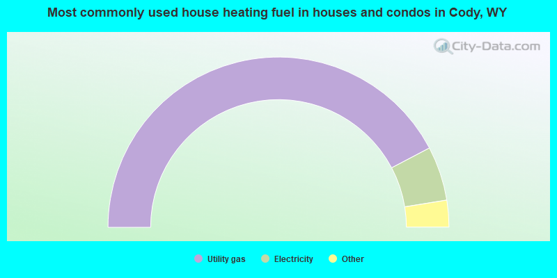
- 84.6%Utility gas
- 10.3%Electricity
- 2.8%Bottled, tank, or LP gas
- 2.3%Wood
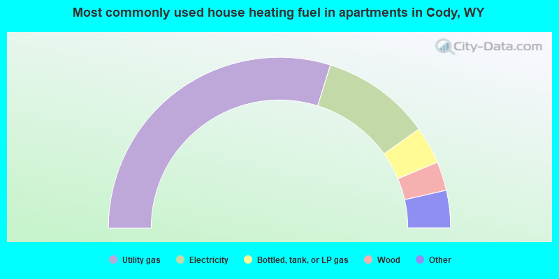
- 59.7%Utility gas
- 20.7%Electricity
- 7.1%Bottled, tank, or LP gas
- 5.5%Wood
- 3.6%Other fuel
- 3.4%No fuel used
Cody compared to Wyoming state average:
- Unemployed percentage significantly below state average.
- Length of stay since moving in significantly above state average.
- Number of college students below state average.
- Percentage of population with a bachelor's degree or higher above state average.
Cody on our top lists:
- #37 on the list of "Top 101 cities with the largest percentage of people in wards in general hospitals for patients who have no usual home elsewhere (population 1,000+)"
- #99 on the list of "Top 101 cities with the most full-time park and recreation workers per 1000 residents (population 5,000+)"
- #69 (82414) on the list of "Top 101 zip codes with the most hotels or motels in 2005"
- #25 on the list of "Top 101 counties with the lowest Particulate Matter (PM2.5) Annual air pollution readings in 2012 (µg/m3)"
- #70 on the list of "Top 101 counties with the lowest Particulate Matter (PM10) Annual air pollution readings in 2012 (µg/m3)"
State forum archive:

|
|
Total of 74 patent applications in 2008-2024.