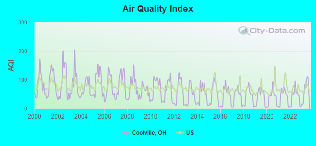
Air Quality Index (AQI) level in 2023 was 64.0. This is about average.
City:
64.0
U.S.:
72.6
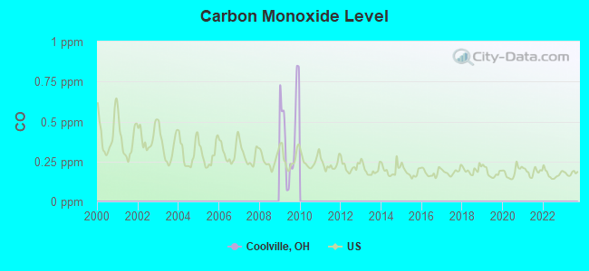
Carbon Monoxide (CO) [ppm] level in 2009 was 0.442. This is significantly worse than average.Closest monitor was 18.2 miles away from the city center.
City:
0.442
U.S.:
0.251
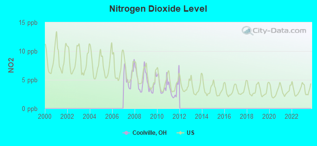
Nitrogen Dioxide (NO2) [ppb] level in 2011 was 3.36. This is significantly better than average.Closest monitor was 18.2 miles away from the city center.
City:
3.36
U.S.:
5.11
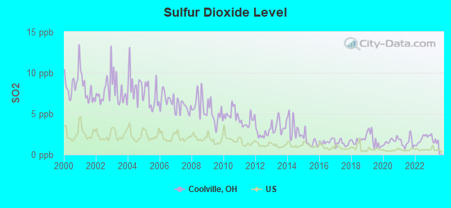
Sulfur Dioxide (SO2) [ppb] level in 2022 was 1.91. This is worse than average.Closest monitor was 7.2 miles away from the city center.
City:
1.91
U.S.:
1.51
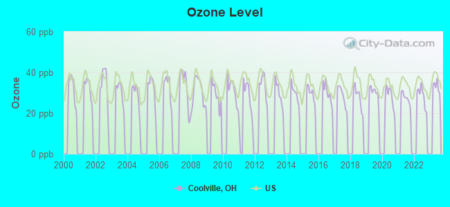
Ozone [ppb] level in 2022 was 28.5. This is about average.Closest monitor was 14.9 miles away from the city center.
City:
28.5
U.S.:
33.3
Tornado activity:
Coolville-area historical tornado activity is significantly below Ohio state average. It is 54% smaller than the overall U.S. average.
On 4/23/1968, a category F5 (max. wind speeds 261-318 mph) tornado 35.2 miles away from the Coolville village center killed 7 peopleand injured 93 peopleand causedbetween $500,000 and $5,000,000 in damages.
On 7/10/2003, a category F2 (max. wind speeds 113-157 mph) tornado 8.1 miles away from the village center caused $2 million in damages.
Earthquake activity:
Coolville-area historical earthquake activity is significantly above Ohio state average. It is 14% smaller than the overall U.S. average.
On 8/23/2011 at 17:51:04, a magnitude 5.8 (5.8 MW, Depth: 3.7 mi, Class: Moderate, Intensity: VI - VII) earthquake occurred 227.7 miles away from Coolville center On 7/27/1980 at 18:52:21, a magnitude 5.2 (5.1 MB, 4.7 MS, 5.0 UK, 5.2 UK) earthquake occurred 135.5 miles away from the city center On 9/25/1998 at 19:52:52, a magnitude 5.2 (4.8 MB, 4.3 MS, 5.2 LG, 4.5 MW, Depth: 3.1 mi) earthquake occurred 173.4 miles away from the city center On 1/31/1986 at 16:46:43, a magnitude 5.0 (5.0 MB) earthquake occurred 168.0 miles away from the city center On 8/9/2020 at 12:07:37, a magnitude 5.1 (5.1 MW, Depth: 4.7 mi) earthquake occurred 193.8 miles away from Coolville center On 9/7/1988 at 02:28:09, a magnitude 4.6 (4.5 MB, 4.6 LG, Class: Light, Intensity: IV - V) earthquake occurred 134.9 miles away from Coolville center Magnitude types: regional Lg-wave magnitude (LG), body-wave magnitude (MB), surface-wave magnitude (MS), moment magnitude (MW)
Natural disasters:
The number of natural disasters in Athens County (16) is near the US average (15). Major Disasters (Presidential) Declared: 10 Emergencies Declared: 3
Causes of natural disasters: Floods: 10, Storms: 10, Landslides: 3, Mudslides: 3, Snowstorms: 2, Tornadoes: 2, Blizzard: 1, Heavy Rain: 1, Hurricane: 1, Wind: 1, Winter Storm: 1, Other: 1 (Note: some incidents may be assigned to more than one category).
Hospitals and medical centers in Coolville:
ARCADIA NURSING CENTER (25675 EAST MAIN STREET)
Other hospitals and medical centers near Coolville:
HOME HEALTH CARE OF SOUTHEAST OHIO, INC (Home Health Center, about 8 miles away; GUYSVILLE, OH)
DAVITA - BELPRE DIALYSIS (Dialysis Facility, about 11 miles away; BELPRE, OH)
DIALYSIS SERVICES OF BELPRE (Dialysis Facility, about 11 miles away; BELPRE, OH)
WILLOWS CENTER (Nursing Home, about 13 miles away; PARKERSBURG, WV)
PARKERSBURG CARE AND REHABILITATION CENTER (Nursing Home, about 13 miles away; PARKERSBURG, WV)
OHIO HOMECARE (Home Health Center, about 13 miles away; BELPRE, OH)
CAMDEN CLARK MEM HOSP (Nursing Home, about 14 miles away; PARKERSBURG, WV)
Colleges/universities with over 2000 students nearest to Coolville:
West Virginia University at Parkersburg (about 16 miles; Parkersburg, WV; Full-time enrollment: 2,619)
Notable locations in Coolville: Southeast Ohio Emergency Medical Services Station 2 Coolville (A), Coolville Volunteer Fire Department Station 1 Headquarters (B). Display/hide their locations on the map
Hotel: Hocking River Getaway (2053 Frost Road (CR 58)).
Athens County has a predicted average indoor radon screening level between 2 and 4 pCi/L (pico curies per liter) - Moderate Potential
Drinking water stations with addresses in Coolville and their reported violations in the past:
COOLVILLE VILLAGE PWS (Population served: 859, Purch groundwater):
Past monitoring violations:
2 routine major monitoring violations
Average household size:
This village:
2.6 people
Ohio:
2.4 people
Percentage of family households:
This village:
73.9%
Whole state:
65.0%
Percentage of households with unmarried partners:
This village:
6.9%
Whole state:
6.8%
Likely homosexual households (counted as self-reported same-sex unmarried-partner households)
Lesbian couples: 0.5% of all households
Gay men: 0.5% of all households
Banks with branches in Coolville (2011 data):
The Hocking Valley Bank: Coolville Branch at 26111 Main Street, branch established on 1997/11/20. Info updated 2006/11/03: Bank assets: $235.9 mil, Deposits: $208.8 mil, headquarters in Athens, OH, positive income, Commercial Lending Specialization, 7 total offices, Holding Company: Hocking Valley Bancshares, Inc.
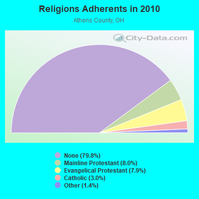
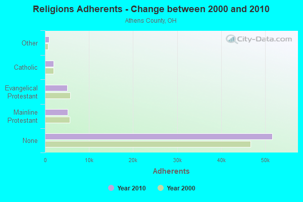
Religion statistics for Coolville, OH (based on Athens County data)
Religion
Adherents
Congregations
Mainline Protestant
5,174
42
Evangelical Protestant
5,093
45
Catholic
1,946
5
Other
890
5
None
51,654
-
Source: Clifford Grammich, Kirk Hadaway, Richard Houseal, Dale E.Jones, Alexei Krindatch, Richie Stanley and Richard H.Taylor. 2012. 2010 U.S.Religion Census: Religious Congregations & Membership Study. Association of Statisticians of American Religious Bodies. Jones, Dale E., et al. 2002. Congregations and Membership in the United States 2000. Nashville, TN: Glenmary Research Center. Graphs represent county-level data
Telephone Bldg On Main St (Lat: 39.228139 Lon: -81.800972), Call Sign: KYB411, Assigned Frequencies: 35.1600 MHz, Grant Date: 05/31/2000, Expiration Date: 08/03/2005, Cancellation Date: 01/07/2006, Registrant: Western Reserve Telephone Company, 245 N Main St, Hudson, OH 44236, Phone: (740) 758-5112
2173 Campbell St (Lat: 39.214444 Lon: -81.801389), Type: Tower, Structure height: 30 m, Call Sign: WQBA352, Assigned Frequencies: 460.112 MHz, Grant Date: 09/16/2014, Expiration Date: 09/07/2024, Certifier: Leonard D Bentley, Registrant: Business Radio Licensing, 30251 Golden Lantern Suite E #501, Laguna Niguel, CA 92677, Phone: (949) 348-8510, Fax: (949) 348-8514, Email:
COOLVILLE, 2165 Campbell St (Lat: 39.214444 Lon: -81.801389), Type: Ltower, Structure height: 24 m, Call Sign: WQTS383, Assigned Frequencies: 158.775 MHz, Grant Date: 04/03/2014, Expiration Date: 05/21/2024, Certifier: Richard B Callebs, Registrant: County Of Athens, 21 Kenny Drive, Athens, OH 45701, Phone: (740) 764-4051, Fax: (740) 764-4094, Email:
FCC Registered Microwave Towers:
5
COOLVILLE, 1.65 Mi W Of Us 50 3.5 Mi Wnw (Coolville- 100012585) (Lat: 39.237972 Lon: -81.853639), Type: Tower, Structure height: 54.9 m, Overall height: 60.6 m, Call Sign: WMJ943, Assigned Frequencies: 6645.00 MHz, Grant Date: 12/28/2010, Expiration Date: 02/01/2021, Cancellation Date: 02/18/2014, Certifier: Glenn S Rabin, Registrant: Verizon Wireless, 1120 Sanctuary Pkwy, #150 Gasa5reg, Alpharetta, GA 30009-7630, Phone: (770) 797-1070, Fax: (770) 797-1036, Email:
Aircraft: MOONEY M20J (Category: Land, Seats: 4, Weight: Up to 12,499 Pounds, Speed: 126 mph), Engine: LYCOMING I0360 SER (180 HP) (Reciprocating) N-Number: 201XH, N201XH, N-201XH, Serial Number: 24-0342, Year manufactured: 1977, Airworthiness Date: 12/16/1977, Certificate Issue Date: 11/09/2016 Registrant (LLC): Homers Investments LLC, 23202 Brister Rd, Coolville, OH 45723
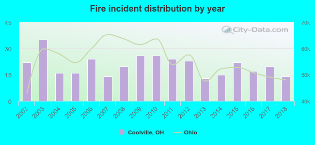
2002 - 2018 National Fire Incident Reporting System (NFIRS) incidents
Based on the data from the years 2002 - 2018 the average number of fire incidents per year is 20. The highest number of reported fire incidents - 35 took place in 2003, and the least - 13 in 2013. The data has a declining trend.
When looking into fire subcategories, the most reports belonged to: Structure Fires (44.7%), and Outside Fires (35.7%).
Fire incident types reported to NFIRS in Coolville, OH
 Recent articles from our blog. Our writers, many of them Ph.D. graduates or candidates, create easy-to-read articles on a wide variety of topics.


 Based on the data from the years 2002 - 2018 the average number of fire incidents per year is 20. The highest number of reported fire incidents - 35 took place in 2003, and the least - 13 in 2013. The data has a declining trend.
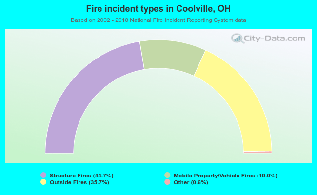 When looking into fire subcategories, the most reports belonged to: Structure Fires (44.7%), and Outside Fires (35.7%).