Glenburn, Maine
Submit your own pictures of this town and show them to the world
- OSM Map
- Google Map
- MSN Map
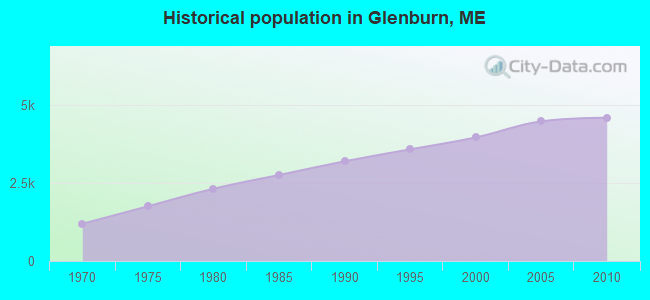
Population change since 2000: +15.9%
 |
| Males: 2,270 | |
| Females: 2,324 |
| Median resident age: | 41.2 years |
| Maine median age: | 43.0 years |
Zip codes: 04401.
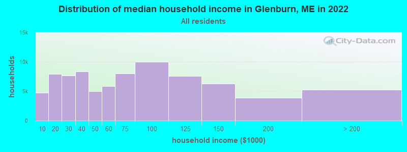
| Glenburn: | $74,710 |
| ME: | $69,543 |
Estimated per capita income in 2022: $35,268 (it was $17,544 in 2000)
Glenburn town income, earnings, and wages data
Estimated median house or condo value in 2022: $229,502 (it was $88,200 in 2000)
| Glenburn: | $229,502 |
| ME: | $290,600 |
Mean prices in 2022: all housing units: $235,563; detached houses: $252,705; townhouses or other attached units: $267,749; in 2-unit structures: $255,332; in 3-to-4-unit structures: $815,300; in 5-or-more-unit structures: $185,873; mobile homes: $93,017; occupied boats, rvs, vans, etc.: $21,333
Detailed information about poverty and poor residents in Glenburn, ME
Compare current foreclosures near Glenburn, ME:
| Photo | Address | Area | Beds / Baths | Price | Details |
|---|---|---|---|---|---|

|
#1
Davenport St
Milford, ME 04461
|
1,200 sq. feet
|
2 baths 3 beds |
$269,900
|
show details |

|
#2
Main St
Bradley, ME 04411
|
1,944 sq. feet
|
2 baths 3 beds |
show details | |

|
#3
Dartmouth St
Old Town, ME 04468
|
2,555 sq. feet
|
3 baths 6 beds |
show details | |

|
#4
Savage St
Bangor, ME 04401
|
1,582 sq. feet
|
2 baths 4 beds |
show details | |

|
#5
Ohio St
Bangor, ME 04401
|
1,628 sq. feet
|
1 baths 4 beds |
show details | |

|
#6
Summer St
Hampden, ME 04444
|
864 sq. feet
|
1 baths 2 beds |
show details | |

|
#7
N Main St
Brewer, ME 04412
|
1,004 sq. feet
|
1 baths 3 beds |
show details | |

|
#8
Riverview Ter
Brewer, ME 04412
|
1,144 sq. feet
|
1 baths 3 beds |
show details | |

|
#9
Lincoln St
Old Town, ME 04468
|
725 sq. feet
|
1 baths 3 beds |
show details | |

|
#10
Church St
Brewer, ME 04412
|
2,548 sq. feet
|
2 baths 3 beds |
show details |
| Photo | Address | Area | Beds / Baths | Price | Details |
|---|---|---|---|---|---|

|
#11
E Summer St
Brewer, ME 04412
|
1,062 sq. feet
|
1 baths 2 beds |
show details | |

|
#12
Stillwater Ave
Old Town, ME 04468
|
1,961 sq. feet
|
2 baths 4 beds |
show details | |

|
#13
Jefferson St
Brewer, ME 04412
|
1,088 sq. feet
|
2 baths 3 beds |
show details | |

|
#14
Getchell St
Brewer, ME 04412
|
1,103 sq. feet
|
1 baths 3 beds |
show details | |

|
#15
Mainewood Ave
Orono, ME 04473
|
1,260 sq. feet
|
1 baths 3 beds |
show details | |

|
#16
Main St
Bangor, ME 04401
|
2,232 sq. feet
|
2 baths 3 beds |
show details | |

|
#17
Water St
Old Town, ME 04468
|
1,018 sq. feet
|
1 baths 3 beds |
show details | |

|
#18
Main Rd N
Hampden, ME 04444
|
2,172 sq. feet
|
2 baths 4 beds |
show details | |

|
#19
Maple St
Milford, ME 04461
|
1,512 sq. feet
|
2 baths 3 beds |
show details | |

|
#20
Century St
Brewer, ME 04412
|
1,652 sq. feet
|
2 baths 4 beds |
show details |
| Photo | Address | Area | Beds / Baths | Price | Details |
|---|---|---|---|---|---|

|
#21
Coolidge Ave
Hampden, ME 04444
|
1,008 sq. feet
|
1 baths 3 beds |
show details | |

|
#22
Western Ave
Hampden, ME 04444
|
1,825 sq. feet
|
1 baths 3 beds |
show details | |

|
#23
S Brewer Dr
Brewer, ME 04412
|
940 sq. feet
|
1 baths 2 beds |
show details | |

|
#24
Main St
Corinth, ME 04427
|
1,573 sq. feet
|
2 baths 3 beds |
show details | |

|
#25
Bog Rd
Hampden, ME 04444
|
1,512 sq. feet
|
3 baths 5 beds |
show details | |

|
#26
Fruit St
Bangor, ME 04401
|
1,224 sq. feet
|
1 baths 2 beds |
show details | |

|
#27
Hancock St
Bangor, ME 04401
|
1,736 sq. feet
|
1 baths 4 beds |
show details | |

|
#28
Forest Ave
Orono, ME 04473
|
2,005 sq. feet
|
2 baths 4 beds |
show details | |

|
#29
Billings Rd
Bangor, ME 04401
|
864 sq. feet
|
2 baths 4 beds |
show details | |

|
#30
Kenduskeag Levant Rd
Kenduskeag, ME 04450
|
- sq. feet
|
2 baths 3 beds |
show details |
| Photo | Address | Area | Beds / Baths | Price | Details |
|---|---|---|---|---|---|

|
#31
Kirkland Rd
Old Town, ME 04468
|
864 sq. feet
|
1 baths 2 beds |
show details | |

|
#32
Sugarloaf Ln
Bangor, ME 04401
|
1,421 sq. feet
|
2 baths 3 beds |
show details | |

|
#33
Billings Rd
Bangor, ME 04401
|
1,512 sq. feet
|
2 baths 3 beds |
show details | |

|
#34
Foxtail Ln
Levant, ME 04456
|
1,190 sq. feet
|
2 baths 3 beds |
show details | |

|
#35
Maple St
Bangor, ME 04401
|
1,926 sq. feet
|
3 baths 4 beds |
show details | |

|
#36
Union St
Bangor, ME 04401
|
1,857 sq. feet
|
2 baths 3 beds |
show details | |

|
#37
Wing Rd
Bangor, ME 04401
|
1,680 sq. feet
|
2 baths 3 beds |
show details | |

|
#38
Fuller Rd
Bangor, ME 04401
|
864 sq. feet
|
1 baths 3 beds |
show details | |

|
#39
Bennoch Rd
Old Town, ME 04468
|
1,244 sq. feet
|
3 baths 4 beds |
show details | |

|
#40
Union St
Levant, ME 04456
|
1,538 sq. feet
|
1 baths 4 beds |
show details |
| Photo | Address | Area | Beds / Baths | Price | Details |
|---|---|---|---|---|---|

|
#41
Elm St
Bangor, ME 04401
|
1,718 sq. feet
|
2 baths 4 beds |
show details | |

|
#42
Grove St
Bangor, ME 04401
|
910 sq. feet
|
1 baths 3 beds |
show details | |

|
#43
Ichabod Ln
Hampden, ME 04444
|
960 sq. feet
|
1 baths 3 beds |
show details | |

|
#44
Allen St
Bangor, ME 04401
|
1,200 sq. feet
|
1 baths 3 beds |
show details | |

|
#45
Cedar St Apt 4
Bangor, ME 04401
|
- sq. feet
|
- baths - beds |
show details | |

|
#46
Grist Mill Rd
Carmel, ME 04419
|
- sq. feet
|
- baths - beds |
show details | |

|
#47
Pleasant Hill Ln
Orrington, ME 04474
|
- sq. feet
|
- baths - beds |
show details | |

|
#48
Exeter Rd
Corinth, ME 04427
|
- sq. feet
|
- baths - beds |
show details | |

|
#49
Broadway
Kenduskeag, ME 04450
|
- sq. feet
|
- baths - beds |
show details | |

|
Check over 1 million property listings on Foreclosure.com!
|
browse all offers | |||

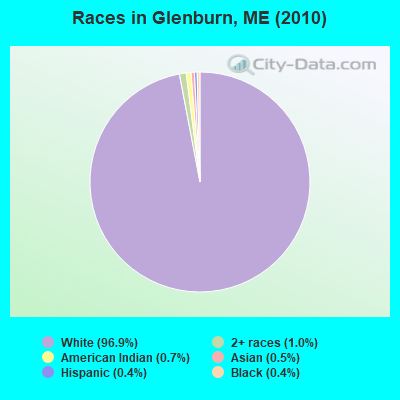
- 4,45396.9%White alone
- 461.0%Two or more races
- 310.7%American Indian alone
- 230.5%Asian alone
- 170.4%Black alone
- 200.4%Hispanic
- 40.09%Other race alone
Races in Glenburn detailed stats: ancestries, foreign born residents, place of birth
According to our research of Maine and other state lists, there were 9 registered sex offenders living in Glenburn, Maine as of June 15, 2024.
The ratio of all residents to sex offenders in Glenburn is 510 to 1.
The ratio of registered sex offenders to all residents in this city is near the state average.
 Recent articles from our blog. Our writers, many of them Ph.D. graduates or candidates, create easy-to-read articles on a wide variety of topics.
Ancestries: English (18.4%), United States (16.6%), Irish (14.8%), French (14.7%), French Canadian (6.9%), Scotch-Irish (5.3%).
Current Local Time: EST time zone
Incorporated on 01/29/1822
Land area: 27.2 square miles.
Population density: 169 people per square mile (very low).
55 residents are foreign born
| This town: | 1.4% |
| Maine: | 2.9% |
| Glenburn town: | 1.4% ($1,266) |
| Maine: | 1.5% ($1,417) |
Nearest city with pop. 50,000+: Portland, ME  (111.7 miles , pop. 64,249).
Nearest city with pop. 200,000+: Boston, MA (211.8 miles , pop. 589,141).
Nearest city with pop. 1,000,000+: Bronx, NY (379.7 miles , pop. 1,332,650).
Nearest cities:
), ), ), ), Latitude: 44.92 N, Longitude: 68.84 W
Area code commonly used in this area: 207
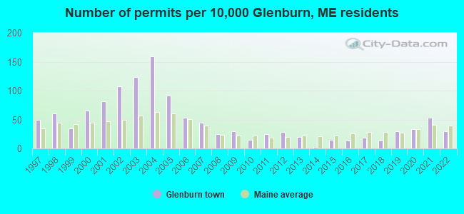
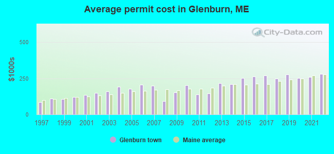
Single-family new house construction building permits:
- 2022: 12 buildings, average cost: $279,200
- 2021: 21 buildings, average cost: $258,200
- 2020: 13 buildings, average cost: $250,800
- 2019: 12 buildings, average cost: $276,800
- 2018: 5 buildings, average cost: $249,800
- 2017: 7 buildings, average cost: $267,800
- 2016: 5 buildings, average cost: $261,800
- 2015: 6 buildings, average cost: $251,900
- 2014: 1 building, cost: $211,200
- 2013: 8 buildings, average cost: $216,500
- 2012: 11 buildings, average cost: $146,400
- 2011: 10 buildings, average cost: $140,400
- 2010: 6 buildings, average cost: $201,500
- 2009: 12 buildings, average cost: $153,600
- 2008: 10 buildings, average cost: $91,200
- 2007: 18 buildings, average cost: $199,600
- 2006: 21 buildings, average cost: $203,600
- 2005: 36 buildings, average cost: $175,700
- 2004: 63 buildings, average cost: $192,600
- 2003: 49 buildings, average cost: $159,000
- 2002: 43 buildings, average cost: $150,000
- 2001: 32 buildings, average cost: $135,700
- 2000: 26 buildings, average cost: $121,300
- 1999: 14 buildings, average cost: $104,700
- 1998: 24 buildings, average cost: $109,600
- 1997: 20 buildings, average cost: $85,800
| Here: | 3.3% |
| Maine: | 3.4% |
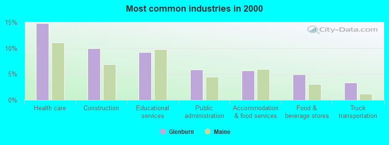
- Health care (14.8%)
- Construction (10.0%)
- Educational services (9.2%)
- Public administration (5.8%)
- Accommodation & food services (5.7%)
- Food & beverage stores (4.9%)
- Truck transportation (3.3%)
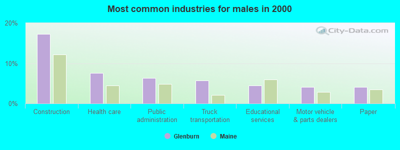
- Construction (17.2%)
- Health care (7.6%)
- Public administration (6.3%)
- Truck transportation (5.7%)
- Educational services (4.5%)
- Motor vehicle & parts dealers (4.1%)
- Paper (4.1%)
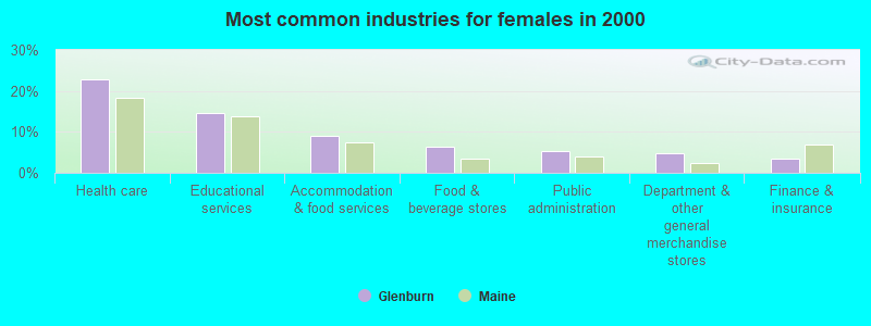
- Health care (23.0%)
- Educational services (14.7%)
- Accommodation & food services (9.1%)
- Food & beverage stores (6.5%)
- Public administration (5.3%)
- Department & other general merchandise stores (4.7%)
- Finance & insurance (3.5%)

- Driver/sales workers and truck drivers (6.6%)
- Retail sales workers, except cashiers (4.5%)
- Other sales and related occupations, including supervisors (4.5%)
- Other management occupations, except farmers and farm managers (3.8%)
- Building and grounds cleaning and maintenance occupations (3.6%)
- Material recording, scheduling, dispatching, and distributing workers (3.3%)
- Health technologists and technicians (3.1%)

- Driver/sales workers and truck drivers (11.8%)
- Material recording, scheduling, dispatching, and distributing workers (4.9%)
- Electrical equipment mechanics and other installation, maintenance, and repair workers, including supervisors (4.8%)
- Other sales and related occupations, including supervisors (4.6%)
- Laborers and material movers, hand (4.1%)
- Construction traders workers except carpenters, electricians, painters, plumbers, and construction laborers (4.1%)
- Metal workers and plastic workers (4.0%)

- Health technologists and technicians (6.1%)
- Retail sales workers, except cashiers (5.8%)
- Other office and administrative support workers, including supervisors (5.3%)
- Cashiers (5.2%)
- Secretaries and administrative assistants (5.0%)
- Other management occupations, except farmers and farm managers (4.6%)
- Other sales and related occupations, including supervisors (4.4%)
Average climate in Glenburn, Maine
Based on data reported by over 4,000 weather stations


(lower is better)
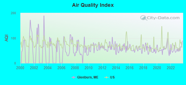
Air Quality Index (AQI) level in 2023 was 61.1. This is about average.
| City: | 61.1 |
| U.S.: | 72.6 |
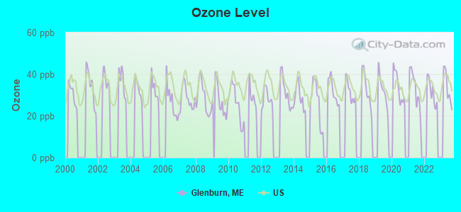
Ozone [ppb] level in 2023 was 33.6. This is about average. Closest monitor was 8.8 miles away from the city center.
| City: | 33.6 |
| U.S.: | 33.3 |
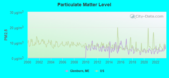
Particulate Matter (PM2.5) [µg/m3] level in 2023 was 5.62. This is significantly better than average. Closest monitor was 7.7 miles away from the city center.
| City: | 5.62 |
| U.S.: | 8.11 |
Earthquake activity:
Glenburn-area historical earthquake activity is significantly above Maine state average. It is 81% smaller than the overall U.S. average.On 4/20/2002 at 10:50:47, a magnitude 5.3 (5.3 ML, Depth: 3.0 mi, Class: Moderate, Intensity: VI - VII) earthquake occurred 240.2 miles away from the city center
On 10/16/2012 at 23:12:25, a magnitude 4.7 (4.7 ML, Depth: 10.0 mi, Class: Light, Intensity: IV - V) earthquake occurred 128.0 miles away from Glenburn center
On 4/20/2002 at 10:50:47, a magnitude 5.2 (5.2 MB, 4.2 MS, 5.2 MW, 5.0 MW) earthquake occurred 241.5 miles away from Glenburn center
On 10/7/1983 at 10:18:46, a magnitude 5.3 (5.1 MB, 5.3 LG, 5.1 ML) earthquake occurred 279.6 miles away from the city center
On 1/19/1982 at 00:14:42, a magnitude 4.7 (4.5 MB, 4.7 MD, 4.5 LG) earthquake occurred 168.2 miles away from Glenburn center
On 2/26/1999 at 03:38:43, a magnitude 3.8 (3.8 LG, Depth: 2.0 mi, Class: Light, Intensity: II - III) earthquake occurred 45.0 miles away from Glenburn center
Magnitude types: regional Lg-wave magnitude (LG), body-wave magnitude (MB), duration magnitude (MD), local magnitude (ML), surface-wave magnitude (MS), moment magnitude (MW)
Natural disasters:
The number of natural disasters in Penobscot County (19) is greater than the US average (15).Major Disasters (Presidential) Declared: 11
Emergencies Declared: 7
Causes of natural disasters: Floods: 9, Storms: 8, Snows: 5, Heavy Rains: 2, Blizzard: 1, Hurricane: 1, Ice Storm: 1, Snowfall: 1, Wind: 1, Winter Storm: 1, Other: 2 (Note: some incidents may be assigned to more than one category).
Hospitals and medical centers near Glenburn:
- BANGOR AREA VISITING NURSES (Home Health Center, about 8 miles away; BANGOR, ME)
- HOSPICE OF EASTERN MAINE (Hospital, about 8 miles away; BANGOR, ME)
- ROSS MANOR (Nursing Home, about 8 miles away; BANGOR, ME)
- KINDRED NURSING AND REHABILITATION-WESTGATE (Nursing Home, about 8 miles away; BANGOR, ME)
- STILLWATER HEALTH CARE (Nursing Home, about 8 miles away; BANGOR, ME)
- ACADIA HOSPITAL,THE (Hospital, about 8 miles away; BANGOR, ME)
- TAYLOR HOSPITAL (Hospital, about 8 miles away; BANGOR, ME)
located in Glenburn:
Colleges/universities with over 2000 students nearest to Glenburn:
- Husson University (about 7 miles; Bangor, ME; Full-time enrollment: 2,421)
- University of Maine (about 9 miles; Orono, ME; FT enrollment: 8,931)
- University of Maine at Augusta (about 62 miles; Augusta, ME; FT enrollment: 3,204)
- University of Maine at Farmington (about 67 miles; Farmington, ME; FT enrollment: 2,036)
- Saint Joseph's College of Maine (about 111 miles; Standish, ME; FT enrollment: 2,010)
- Southern Maine Community College (about 112 miles; South Portland, ME; FT enrollment: 4,666)
- University of Southern Maine (about 113 miles; Portland, ME; FT enrollment: 6,647)
Public elementary/middle school in Glenburn:
- GLENBURN ELEMENTARY SCHOOL (Location: 991 HUDSON RD, Grades: PK-8)
Points of interest:
Notable locations in Glenburn: Glenburn and Hudson Ambulance Service (A), Glenburn Library (B), Glenburn Fire Department Station 22 (C), Glenburn Fire Department Station 23 (D). Display/hide their locations on the map
Church in Glenburn: Glenburn Evangelical Church (A). Display/hide its location on the map
Cemeteries: Pleasant View Cemetery (1), Birch Grove Cemetery (2), Lakeview Cemetery (3). Display/hide their locations on the map
Reservoirs and swamps: Pushaw Lake (A), Halfmoon Meadow (B), Hollis Bog (C), Marston Meadow (D). Display/hide their locations on the map
Streams, rivers, and creeks: Lancaster Brook (A), Black Stream (B). Display/hide their locations on the map
Drinking water stations with addresses in Glenburn and their reported violations in the past:
GLENBURN MUNICIPAL BUILDING (Population served: 30, Groundwater):Past health violations:Past monitoring violations:
- MCL, Monthly (TCR) - In AUG-2006, Contaminant: Coliform. Follow-up actions: St Public Notif requested (AUG-28-2006), St Violation/Reminder Notice (AUG-28-2006), St Public Notif received (2 times from OCT-16-2006 to OCT-16-2006), St Compliance achieved (SEP-07-2011), St Intentional no-action (SEP-09-2011)
- One routine major monitoring violation
| This town: | 2.5 people |
| Maine: | 2.3 people |
| This town: | 71.9% |
| Whole state: | 62.9% |
| This town: | 11.1% |
| Whole state: | 9.4% |
Likely homosexual households (counted as self-reported same-sex unmarried-partner households)
- Lesbian couples: 0.4% of all households
- Gay men: 0.4% of all households
| This town: | 11.0% |
| Whole state: | 10.9% |
| This town: | 3.9% |
| Whole state: | 4.1% |
For population 15 years and over in Glenburn:
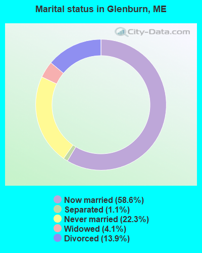
- Never married: 22.3%
- Now married: 58.6%
- Separated: 1.1%
- Widowed: 4.1%
- Divorced: 13.9%
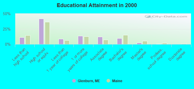
For population 25 years and over in Glenburn:
- High school or higher: 89.0%
- Bachelor's degree or higher: 12.8%
- Graduate or professional degree: 3.2%
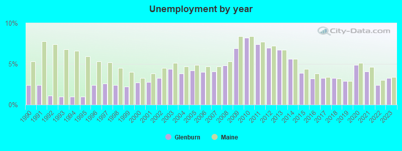
- Unemployed: 4.0%
- Mean travel time to work (commute): 23.2 minutes
| Here: | 8.6 |
| Maine average: | 11.2 |


Graphs represent county-level data. Detailed 2008 Election Results
Religion statistics for Glenburn, ME (based on Penobscot County data)


| Religion | Adherents | Congregations |
|---|---|---|
| Catholic | 16,581 | 15 |
| Mainline Protestant | 9,715 | 59 |
| Evangelical Protestant | 7,523 | 80 |
| Other | 2,936 | 22 |
| Orthodox | 300 | 1 |
| None | 116,868 | - |
Food Environment Statistics:
| This county: | 2.29 / 10,000 pop. |
| Maine: | 2.80 / 10,000 pop. |
| Here: | 0.13 / 10,000 pop. |
| State: | 0.14 / 10,000 pop. |
| Penobscot County: | 2.56 / 10,000 pop. |
| Maine: | 2.20 / 10,000 pop. |
| Here: | 5.72 / 10,000 pop. |
| State: | 5.75 / 10,000 pop. |
| This county: | 7.41 / 10,000 pop. |
| Maine: | 11.02 / 10,000 pop. |
| Penobscot County: | 9.0% |
| Maine: | 8.2% |
| This county: | 28.0% |
| State: | 25.0% |
Businesses in Glenburn, ME
- U-Haul: 1
Strongest AM radio stations in Glenburn:
- WZON (620 AM; 5 kW; BANGOR, ME; Owner: THE ZONE CORPORATION)
- WABI (910 AM; 5 kW; BANGOR, ME; Owner: CLEAR CHANNEL BROADCASTING LICENSES, INC.)
- WNZS (1340 AM; 1 kW; VEAZIE, ME; Owner: WATERFRONT COMMUNICATIONS INC.)
- WSKW (1160 AM; 10 kW; SKOWHEGAN, ME; Owner: MOUNTAIN WIRELESS, INCORPORATED)
- WDEA (1370 AM; 5 kW; ELLSWORTH, ME; Owner: CUMULUS LICENSING CORP.)
- WRKO (680 AM; 50 kW; BOSTON, MA; Owner: ENTERCOM BOSTON LICENSE, LLC)
- WTME (780 AM; 10 kW; RUMFORD, ME; Owner: MOUNTAIN VALLEY BROADCASTING, INC.)
- WEEI (850 AM; 50 kW; BOSTON, MA; Owner: ENTERCOM BOSTON LICENSE, LLC)
- WBZ (1030 AM; 50 kW; BOSTON, MA; Owner: INFINITY BROADCASTING OPERATIONS, INC.)
- WCRN (830 AM; 50 kW; WORCESTER, MA; Owner: CARTER BROADCASTING CORPORATION)
- WNNZ (640 AM; 50 kW; WESTFIELD, MA; Owner: CLEAR CHANNEL BROADCASTING LICENSES, INC.)
- WFAU (1280 AM; 5 kW; GARDINER, ME; Owner: CAPSTAR TX LIMITED PARTNERSHIP)
- WCHP (760 AM; 35 kW; CHAMPLAIN, NY; Owner: CHAMPLAIN RADIO, INC.)
Strongest FM radio stations in Glenburn:
- WBZN (107.3 FM; OLD TOWN, ME; Owner: CUMULUS LICENSING CORP.)
- WWBX (97.1 FM; BANGOR, ME; Owner: CLEAR CHANNEL BROADCASTING LICENSES, INC.)
- WVOM (103.9 FM; HOWLAND, ME; Owner: CLEAR CHANNEL BROADCASTING LICENSES, INC.)
- WQCB (106.5 FM; BREWER, ME; Owner: CUMULUS LICENSING CORP.)
- WKIT-FM (100.3 FM; BREWER, ME; Owner: THE ZONE CORPORATION)
- WHCF (88.5 FM; BANGOR, ME; Owner: BANGOR BAPTIST CHURCH)
- WMEH (90.9 FM; BANGOR, ME; Owner: MAINE PUBLIC BROADCASTING CORPORATION)
- WEZQ (92.9 FM; BANGOR, ME; Owner: CUMULUS LICENSING CORP.)
- WWMJ (95.7 FM; ELLSWORTH, ME; Owner: CUMULUS LICENSING CORP.)
- WBFB (104.7 FM; BELFAST, ME; Owner: CLEAR CHANNEL BROADCASTING LICENSES, INC.)
- WGUY (102.1 FM; DEXTER, ME; Owner: CONCORD MEDIA GROUP, INC.)
- WMEB-FM (91.9 FM; ORONO, ME; Owner: UNIVERSITY OF MAINE SYSTEM)
- WFZX (101.7 FM; SEARSPORT, ME; Owner: CLEAR CHANNEL BROADCASTING LICENSES, INC.)
- WERU-FM (89.9 FM; BLUE HILL, ME; Owner: SALT POND COMMUNITY B/C COMPANY)
- WHSN (89.3 FM; BANGOR, ME; Owner: HUSSON COLLEGE)
- WJCX (99.5 FM; PITTSFIELD, ME; Owner: CSN INTERNATIONAL)
- W275AE (102.9 FM; BANGOR, ME; Owner: SALT POND COMMUNITY BROADCASTING, INC.)
TV broadcast stations around Glenburn:
- WABI-TV (Channel 5; BANGOR, ME; Owner: COMMUNITY BROADCASTING SERVICE)
- WMEB-TV (Channel 12; ORONO, ME; Owner: MAINE PUBLIC BROADCASTING CORPORATION)
- WLBZ (Channel 2; BANGOR, ME; Owner: PACIFIC AND SOUTHERN COMPANY, INC.)
- WBGR-LP (Channel 33; BANGOR/DEDHAM, ME; Owner: MAINE FAMILY BROADCASTING, INC.)
- WCKD-LP (Channel 30; BANGOR/DEDHAM, ME; Owner: J. MCLEOD, ME FAMILY B/CING., INC.)
- W36CK (Channel 36; BANGOR, ME; Owner: TRINITY BROADCASTING NETWORK)
- W66CL (Channel 66; BANGOR, ME; Owner: MS COMMUNICATIONS, LLC)
- WBAN-LP (Channel 9; BANGOR, ME; Owner: BANGOR MEDIA GROUP, LLC)
FCC Registered Antenna Towers:
2- James Riley, Wilson Way (Lat: 44.874778 Lon: -68.851944), Type: 57.9, Structure height: 23019 m, Overall height: 57.9 m, Registrant: Bay Communications Iv, LLC, Jriley@baycommunicationsllc.Com, , East -Sandwich, Phone: (508) 337-8000
- James Riley, Wilson Way (Lat: 44.874778 Lon: -68.851944), Type: 57.9, Structure height: 23019 m, Overall height: 57.9 m, Registrant: Bay Communications Iv, LLC, Jriley@baycommunicationsllc.Com, , East -Sandwich, Phone: (508) 337-8000
FCC Registered Microwave Towers:
1- Glenburn, Route 222 (Lat: 44.864139 Lon: -68.908028), Type: Tower, Structure height: 59.4 m, Overall height: 60.6 m, Call Sign: WQJF677,
Assigned Frequencies: 10628.1 MHz, Grant Date: 08/21/2008, Expiration Date: 08/21/2018, Cancellation Date: 08/06/2015, Certifier: John T Scott Iii, Registrant: Verizon Wireless, 1120 Sanctuary Pkwy, #150 Gasa5reg, Alpharetta, GA 30009-7630, Phone: (770) 797-1070, Fax: (770) 797-1036, Email:
FCC Registered Amateur Radio Licenses:
18 (See the full list of FCC Registered Amateur Radio Licenses in Glenburn)FAA Registered Aircraft:
7- Aircraft: CIRRUS DESIGN CORP SR22 (Category: Land, Seats: 4, Weight: Up to 12,499 Pounds), Engine: CONT MOTOR IO-550 SERIES (300 HP) (Reciprocating)
N-Number: 224JC, N224JC, N-224JC, Serial Number: 0914, Year manufactured: 2004, Airworthiness Date: 04/29/2004, Certificate Issue Date: 03/16/2015
Registrant (Co-Owned): Ventures & Agency Services Inc 109, 118 Cedar Breeze S, Glenburn, ME 04401, Other Owners: LLC Nsg-1 - Aircraft: PIPER PA-18-150 (Category: Land, Seats: 2, Weight: Up to 12,499 Pounds, Speed: 97 mph), Engine: LYCOMING 0-320 SERIES (180 HP) (Reciprocating)
N-Number: 3860Z, N3860Z, N-3860Z, Serial Number: 18-7633, Year manufactured: 1961, Airworthiness Date: 05/11/1961, Certificate Issue Date: 09/27/2010
Registrant (Individual): Robert C Krueger, 40 Cedar Breeze N, Glenburn, ME 04401 - Aircraft: TAYLORCRAFT BC12-D (Category: Land, Seats: 2, Weight: Up to 12,499 Pounds, Speed: 78 mph), Engine: CONT MOTOR A&C65 SERIES (65 HP) (Reciprocating)
N-Number: 43040, N43040, N-43040, Serial Number: 6699, Year manufactured: 1946, Airworthiness Date: 04/09/1955, Certificate Issue Date: 09/27/2010
Registrant (Individual): Robert C Krueger, 40 Cedar Breeze N, Glenburn, ME 04401 - Aircraft: CHAMPION 7CCM (Category: Land, Seats: 2, Weight: Up to 12,499 Pounds, Speed: 90 mph), Engine: CONT MOTOR C90-12F (95 HP) (Reciprocating)
N-Number: 4575E, N4575E, N-4575E, Serial Number: 7CCM-142, Year manufactured: 1949, Airworthiness Date: 04/04/2007, Certificate Issue Date: 06/09/1973
Registrant (Individual): John S Jr Craig, 61 Pine Hill Dr, Glenburn, ME 04401 - Aircraft: CESSNA 180G (Category: Land, Seats: 6, Weight: Up to 12,499 Pounds, Speed: 121 mph), Engine: CONT MOTOR O-470 SERIES (230 HP) (Reciprocating)
N-Number: 4666U, N4666U, N-4666U, Serial Number: 18051366, Year manufactured: 1964, Airworthiness Date: 05/28/1982, Certificate Issue Date: 03/13/2019
Registrant (LLC): Paradise Adventures LLC, 35 Aspen Ridge Rd, Glenburn, ME 04401 - Aircraft: PIPER PA-11 (Category: Land, Seats: 2, Weight: Up to 12,499 Pounds, Speed: 67 mph), Engine: CONT MOTOR C90 SERIES (95 HP) (Reciprocating)
N-Number: 4677M, N4677M, N-4677M, Serial Number: 11-186, Year manufactured: 1947, Airworthiness Date: 05/14/1956, Certificate Issue Date: 12/17/1975
Registrant (Individual): Timothy D Hodgkins, 35 Luckys Landing Rd, Glenburn, ME 04401 - Aircraft: AERONCA 7AC (Category: Land, Seats: 2, Weight: Up to 12,499 Pounds, Speed: 90 mph), Engine: CONT MOTOR C90 SERIES (95 HP) (Reciprocating)
N-Number: 82015, N82015, N-82015, Serial Number: 7AC-641, Year manufactured: 1946, Airworthiness Date: 08/27/1979, Certificate Issue Date: 05/15/1978
Registrant (Individual): John S Jr Craig, 61 Pine Hill Dr, Glenburn, ME 04401
2003 - 2018 National Fire Incident Reporting System (NFIRS) incidents
- Fire incident types reported to NFIRS in Glenburn, ME
- 9369.4%Structure Fires
- 3022.4%Outside Fires
- 86.0%Mobile Property/Vehicle Fires
- 32.2%Other
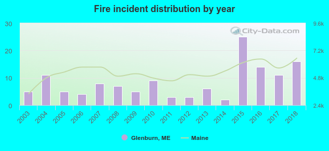 According to the data from the years 2003 - 2018 the average number of fire incidents per year is 8. The highest number of reported fire incidents - 25 took place in 2015, and the least - 2 in 2014. The data has an increasing trend.
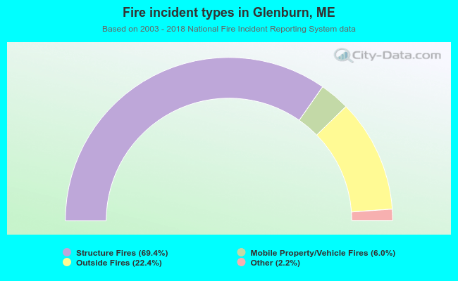 When looking into fire subcategories, the most incidents belonged to: Structure Fires (69.4%), and Outside Fires (22.4%).
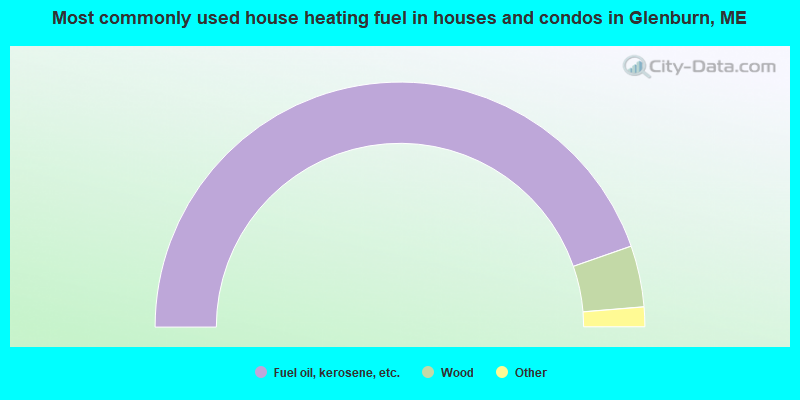
- 89.3%Fuel oil, kerosene, etc.
- 8.1%Wood
- 1.9%Bottled, tank, or LP gas
- 0.7%Electricity
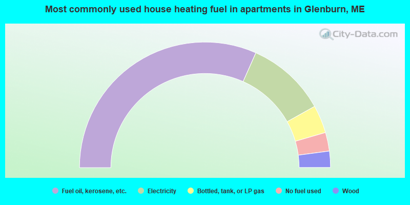
- 63.3%Fuel oil, kerosene, etc.
- 20.5%Electricity
- 7.2%Bottled, tank, or LP gas
- 4.8%No fuel used
- 4.2%Wood
Glenburn compared to Maine state average:
- Unemployed percentage significantly below state average.
- Black race population percentage significantly below state average.
- Hispanic race population percentage significantly below state average.
- Foreign-born population percentage significantly below state average.
- Renting percentage below state average.
- Length of stay since moving in significantly above state average.
- Number of rooms per house significantly below state average.
- House age significantly below state average.
- Percentage of population with a bachelor's degree or higher below state average.

|
|
Total of 8 patent applications in 2008-2024.