Imnaha, Oregon

Submit your own pictures of this place and show them to the world
- OSM Map
- General Map
- Google Map
- MSN Map

| Males: 134 | |
| Females: 119 |
| Median resident age: | 46.6 years |
| Oregon median age: | 36.3 years |
Zip code: 97842
| Imnaha: | $37,054 |
| OR: | $75,657 |
Estimated per capita income in 2022: $24,363 (it was $11,083 in 2000)
Imnaha CCD income, earnings, and wages data
Estimated median house or condo value in 2022: $524,898 (it was $164,800 in 2000)
| Imnaha: | $524,898 |
| OR: | $475,600 |
Mean prices in 2022: all housing units: $473,224; detached houses: $509,938; mobile homes: $235,906
Detailed information about poverty and poor residents in Imnaha, OR
Compare current foreclosures near Imnaha, OR:
| Photo | Address | Area | Beds / Baths | Price | Details |
|---|---|---|---|---|---|

|
#1
NE 1st St
Enterprise, OR 97828
|
- sq. feet
|
- baths - beds |
show details | |

|
#2
Roberts St
Enterprise, OR 97828
|
- sq. feet
|
- baths - beds |
show details | |

|
Check over 1 million property listings on Foreclosure.com!
|
browse all offers | |||

- 24691.8%White alone
- 145.2%Hispanic
- 62.2%Two or more races
- 20.7%Other race alone

Races in Imnaha detailed stats: ancestries, foreign born residents, place of birth
 Recent articles from our blog. Our writers, many of them Ph.D. graduates or candidates, create easy-to-read articles on a wide variety of topics.
Current Local Time: PST time zone
Elevation: 1965 feet
Land area: 1527.7 square miles.
Population density: 0.2 people per square mile (very low).

| Imnaha CCD: | 0.3% ($567) |
| Oregon: | 1.2% ($1,687) |
Nearest city with pop. 50,000+: Kennewick, WA  (113.4 miles , pop. 54,693).
Nearest city with pop. 200,000+: Northwest Clackamas, OR (273.0 miles , pop. 224,220).
Nearest city with pop. 1,000,000+: Los Angeles, CA (797.0 miles , pop. 3,694,820).
Nearest cities:
Latitude: 45.56 N, Longitude: 116.99 W
Area code commonly used in this area: 541


| Here: | 4.6% |
| Oregon: | 3.9% |

- Agriculture, forestry, fishing & hunting (68.7%)
- Food & beverage stores (10.1%)
- Construction (5.1%)
- Health care (5.1%)
- Administrative & support & waste management services (4.0%)
- Accommodation & food services (4.0%)
- Wood products (3.0%)

- Agriculture, forestry, fishing & hunting (80.3%)
- Construction (8.2%)
- Administrative & support & waste management services (6.6%)
- Wood products (4.9%)
- Food (0.0%)

- Agriculture, forestry, fishing & hunting (50.0%)
- Food & beverage stores (26.3%)
- Health care (13.2%)
- Accommodation & food services (10.5%)

- Farmers and farm managers (17.2%)
- Supervisors and other personal care and service workers, except child care workers (17.2%)
- Agricultural workers, including supervisors (13.1%)
- Woodworkers (10.1%)
- Building and grounds cleaning and maintenance occupations (8.1%)
- Material recording, scheduling, dispatching, and distributing workers (6.1%)
- Carpenters (6.1%)

- Agricultural workers, including supervisors (21.3%)
- Farmers and farm managers (18.0%)
- Woodworkers (16.4%)
- Carpenters (9.8%)
- Vehicle and mobile equipment mechanics, installers, and repairers (8.2%)
- Building and grounds cleaning and maintenance occupations (6.6%)
- Supervisors and other personal care and service workers, except child care workers (6.6%)

- Supervisors and other personal care and service workers, except child care workers (34.2%)
- Farmers and farm managers (15.8%)
- Material recording, scheduling, dispatching, and distributing workers (15.8%)
- Secretaries and administrative assistants (13.2%)
- Building and grounds cleaning and maintenance occupations (10.5%)
- Other sales and related occupations, including supervisors (10.5%)
- Other management occupations, except farmers and farm managers (0.0%)
Average climate in Imnaha, Oregon
Based on data reported by over 4,000 weather stations


(lower is better)

Air Quality Index (AQI) level in 2023 was 48.9. This is significantly better than average.
| City: | 48.9 |
| U.S.: | 72.6 |

Particulate Matter (PM2.5) [µg/m3] level in 2023 was 4.83. This is significantly better than average. There were 0 monitors within city limits.
| City: | 4.83 |
| U.S.: | 8.11 |
Earthquake activity:
Imnaha-area historical earthquake activity is significantly above Oregon state average. It is 1170% greater than the overall U.S. average.On 10/28/1983 at 14:06:06, a magnitude 7.3 (6.2 MB, 7.3 MS, 7.0 MW, Class: Major, Intensity: VIII - XII) earthquake occurred 187.2 miles away from Imnaha center, causing 2 deaths (2 shaking deaths) and 3 injuries, causing $15,000,000 total damage
On 8/18/1959 at 06:37:13, a magnitude 7.7 (7.7 UK) earthquake occurred 317.1 miles away from Imnaha center, causing $26,000,000 total damage
On 10/3/1915 at 06:52:48, a magnitude 7.6 (7.6 UK) earthquake occurred 350.9 miles away from the city center
On 3/31/2020 at 23:52:30, a magnitude 6.5 (6.5 MW, Depth: 7.5 mi, Class: Strong, Intensity: VII - IX) earthquake occurred 119.0 miles away from the city center
On 4/13/1949 at 19:55:42, a magnitude 7.0 (7.0 UK) earthquake occurred 287.4 miles away from Imnaha center, causing $80,000,000 total damage
On 2/28/2001 at 18:54:32, a magnitude 6.8 (6.5 MB, 6.6 MS, 6.8 MW) earthquake occurred 286.9 miles away from the city center, causing $2,000,000,000 total damage and $305,000,000 insured losses
Magnitude types: body-wave magnitude (MB), surface-wave magnitude (MS), moment magnitude (MW)
Natural disasters:
The number of natural disasters in Wallowa County (9) is smaller than the US average (15).Major Disasters (Presidential) Declared: 6
Emergencies Declared: 2
Causes of natural disasters: Floods: 5, Storms: 3, Winter Storms: 2, Drought: 1, Heavy Rain: 1, Hurricane: 1, Landslide: 1, Mudslide: 1, Snow: 1, Other: 1 (Note: some incidents may be assigned to more than one category).
Airports located in Imnaha:
- Memaloose Airport (25U) (Runways: 1, Air Taxi Ops: 150, Itinerant Ops: 450)
Colleges/universities with over 2000 students nearest to Imnaha:
- Eastern Oregon University (about 56 miles; La Grande, OR; Full-time enrollment: 3,127)
- Lewis-Clark State College (about 59 miles; Lewiston, ID; FT enrollment: 3,199)
- Walla Walla Community College (about 72 miles; Walla Walla, WA; FT enrollment: 4,263)
- University of Idaho (about 81 miles; Moscow, ID; FT enrollment: 10,416)
- Washington State University (about 82 miles; Pullman, WA; FT enrollment: 25,055)
- Treasure Valley Community College (about 107 miles; Ontario, OR; FT enrollment: 2,055)
- Columbia Basin College (about 113 miles; Pasco, WA; FT enrollment: 5,111)
Points of interest:
Notable locations in Imnaha: Kneeland Place (A), Zumwalt School (B), Hidden Recreation Site (C), Evergreen Recreation Site (D), Ollokot Recreation Site (E), Kirkland Campground (F), Sacajawea Recreation Site (G), Thomason Meadow Guard Station (H), Imnaha Grange (I), Hunting Camp Cow Camp (J), Horse Creek Cabin (K), Hollow Log Cow Camp (L), Hinton Ranch (M), Hay Pen Camp (N), Vermillion Bar Campground (O), Hells Canyon Creek Recreation Site (P), Mahogany Corral (Q), Marr Flat Cow Camp (R), Harl Butte Lookout (S), Little Creek Fish Weir Recreation Site (T). Display/hide their locations on the map
Cemeteries: Park Cemetery (1), Imnaha Cemetery (2). Display/hide their locations on the map
Lakes and reservoirs: Frog Pond (A), Twin Lakes (B), Warm Lake (C), Downey Lake (D), Hayden Lake (E), Nuxall Lake (F), Sprudy Lake (G), Marshman Lake (H). Display/hide their locations on the map
Streams, rivers, and creeks: Wing Creek (A), Winston Creek (B), Yreka Creek (C), Magpie Creek (D), West Fork Somer Creek (E), Hangover Creek (F), Kirby Creek (G), Neil Creek (H), Boneyard Creek (I). Display/hide their locations on the map
Park in Imnaha: Wayside Springs Forest Camp (1). Display/hide its location on the map
| This place: | 2.2 people |
| Oregon: | 2.5 people |
| This place: | 66.1% |
| Whole state: | 63.4% |
| This place: | 8.0% |
| Whole state: | 8.0% |
Likely homosexual households (counted as self-reported same-sex unmarried-partner households)
- Lesbian couples: 0.0% of all households
- Gay men: 0.9% of all households
| This place: | 28.5% |
| Whole state: | 11.6% |
| This place: | 18.6% |
| Whole state: | 5.0% |
For population 15 years and over in Imnaha:

- Never married: 24.1%
- Now married: 59.2%
- Separated: 4.0%
- Widowed: 10.9%
- Divorced: 5.7%
For population 25 years and over in Imnaha:
- High school or higher: 81.5%
- Bachelor's degree or higher: 11.6%
- Graduate or professional degree: 2.7%
- Mean travel time to work (commute): 25.8 minutes


| Here: | 10.6 |
| Oregon average: | 11.5 |
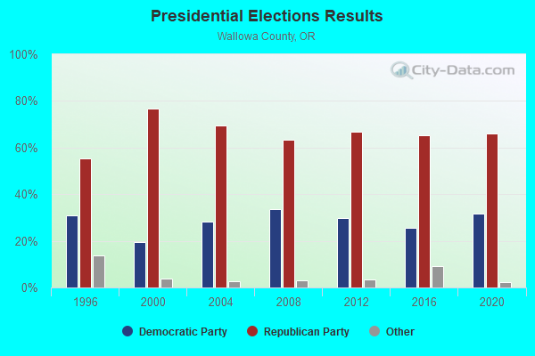
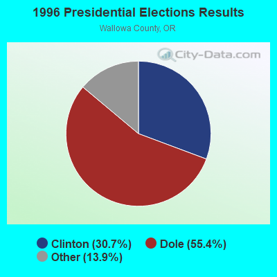
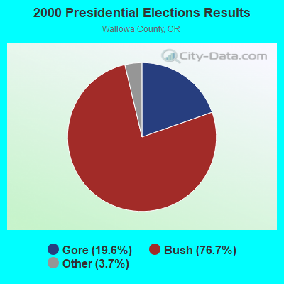
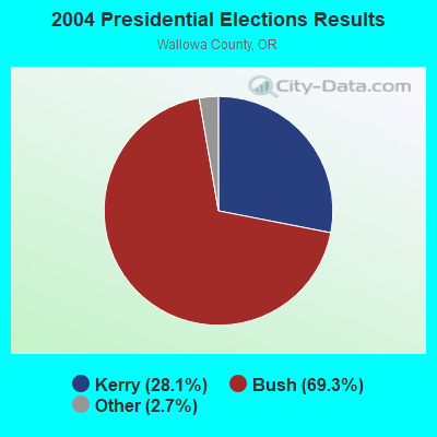


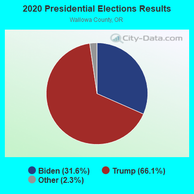
Graphs represent county-level data. Detailed 2008 Election Results
Religion statistics for Imnaha, OR (based on Wallowa County data)
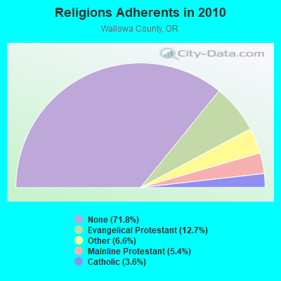
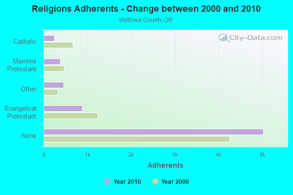
| Religion | Adherents | Congregations |
|---|---|---|
| Evangelical Protestant | 887 | 13 |
| Other | 462 | 4 |
| Mainline Protestant | 377 | 6 |
| Catholic | 250 | 2 |
| None | 5,032 | - |
Food Environment Statistics:
| This county: | 10.38 / 10,000 pop. |
| Oregon: | 2.03 / 10,000 pop. |
| Wallowa County: | 2.96 / 10,000 pop. |
| State: | 2.01 / 10,000 pop. |
| Wallowa County: | 1.48 / 10,000 pop. |
| Oregon: | 1.69 / 10,000 pop. |
| Wallowa County: | 29.65 / 10,000 pop. |
| Oregon: | 9.93 / 10,000 pop. |
| Here: | 8.8% |
| Oregon: | 7.4% |
| Here: | 25.9% |
| Oregon: | 25.6% |
| This county: | 10.0% |
| Oregon: | 14.2% |
Strongest AM radio stations in Imnaha:
- KWEI (1260 AM; 50 kW; WEISER, ID; Owner: TREASURE VALLEY BROADCASTING CO.)
- KQQQ (1150 AM; 25 kW; PULLMAN, WA; Owner: RADIO PALOUSE, INC.)
- KBOI (670 AM; 50 kW; BOISE, ID; Owner: CITADEL BROADCASTING COMPANY)
- KWVR (1340 AM; 1 kW; ENTERPRISE, OR; Owner: WALLOWA VALLEY RADIO BROADCASTING CORP.)
- KTBI (810 AM; daytime; 50 kW; EPHRATA, WA; Owner: TACOMA BROADCASTERS, INCORPORATED)
- KGA (1510 AM; 50 kW; SPOKANE, WA; Owner: CITADEL BROADCASTING COMPANY)
- KERR (750 AM; 50 kW; POLSON, MT; Owner: ANDERSON RADIO BROADCASTING, INC.)
- KOZE (950 AM; 5 kW; LEWISTON, ID; Owner: 4-K RADIO, INC.)
- KCLK (1430 AM; 5 kW; ASOTIN, WA; Owner: CLARKSTON BROADCASTERS, INC.)
- KMAX (840 AM; 10 kW; COLFAX, WA; Owner: PALOUSE COUNTRY, INC.)
- KRLC (1350 AM; 5 kW; CLARKSTON LEWISTON,, WA; Owner: IDA-VEND COMPANY, INC.)
- KXLY (920 AM; 20 kW; SPOKANE, WA; Owner: SPOKANE RADIO, INC.)
- KPOJ (620 AM; 50 kW; PORTLAND, OR; Owner: CITICASTERS LICENSES, L.P.)
Strongest FM radio stations in Imnaha:
- K208DB (89.5 FM; ENTERPRISE, ETC., OR; Owner: WALLOWA VALLEY TV ASSOCIATION, INC.)
- K234AD (94.7 FM; ENTERPRISE, OR; Owner: WALLOWA VALLEY TV ASSOCIATION, INC.)
- KUBQ (98.7 FM; LA GRANDE, OR; Owner: GRANDE RADIO, INC.)
- KORT-FM (92.7 FM; GRANGEVILLE, ID; Owner: 4-K RADIO, INC.)
- KNWO (90.1 FM; COTTONWOOD, ID; Owner: WASHINGTON STATE UNIVERSITY)
- KCMB (104.7 FM; BAKER, OR; Owner: OREGON TRAIL RADIO, INC.)
- KBSK (89.9 FM; MCCALL, ID; Owner: IDAHO STATE BOARD OF EDUCATION)
- KBSQ (90.7 FM; MCCALL, ID; Owner: IDAHO STATE BOARD OF EDUCATION)
- KBSM (91.7 FM; MCCALL, ID; Owner: IDAHO STATE BOARD OF EDUC. (B.S.U.))
Imnaha fatal accident list:
FCC Registered Broadcast Land Mobile Towers:
2- 68736 Imnaha Hwy (Lat: 45.428222 Lon: -116.834861), Type: Pole, Structure height: 9 m, Call Sign: WPGF972,
Assigned Frequencies: 467.000 MHz, Grant Date: 11/02/1999, Expiration Date: 01/04/2005, Cancellation Date: 03/12/2005, Registrant: Big Sheep Creek Ranch, Enterprise, OR 97828, Phone: (503) 577-3214
- 68736 Imnaha Hwy (Lat: 45.428222 Lon: -116.834861), Type: Pole, Structure height: 9 m, Call Sign: WQEV971,
Assigned Frequencies: 467.000 MHz, Grant Date: 04/06/2016, Expiration Date: 05/01/2026, Certifier: Jack Thompson, Registrant: Wildecat Ranch, Joseph, OR 97846, Phone: (541) 577-3214, Email:
FCC Registered Microwave Towers:
2- IMNAHA, Sheep Creek Highway (Lat: 45.559028 Lon: -116.834028), Type: Ltower, Structure height: 15.2 m, Call Sign: WDU585,
Assigned Frequencies: 6655.00 MHz, 6655.00 MHz, 11565.0 MHz, 11565.0 MHz, 11565.0 MHz, 11565.0 MHz, 11565.0 MHz, 11565.0 MHz, 11565.0 MHz, 11645.0 MHz... (+6 more), Grant Date: 04/15/2021, Expiration Date: 02/01/2031, Certifier: Byron E Springer Jr., Registrant: Micronet Communications, Inc., 812 Lexington Dr, Plano, TX 75075, Phone: (972) 422-7200, Email:
- SQUAW GULCH, 3.1 Mi Sw Of (Lat: 45.537361 Lon: -116.892083), Type: Ltower, Structure height: 12.8 m, Call Sign: WDU586,
Assigned Frequencies: 6815.00 MHz, 6815.00 MHz, 6655.00 MHz, 11075.0 MHz, 11245.0 MHz, 11075.0 MHz, 11245.0 MHz, 11075.0 MHz, 11245.0 MHz, 11075.0 MHz... (+19 more), Grant Date: 04/15/2021, Expiration Date: 02/01/2031, Certifier: Byron E Springer Jr., Registrant: Micronet Communications, Inc., 812 Lexington Dr, Plano, TX 75075, Phone: (972) 422-7200, Email:

- 63.9%Wood
- 26.2%Electricity
- 9.8%Fuel oil, kerosene, etc.

- 46.0%Wood
- 28.0%Electricity
- 14.0%Bottled, tank, or LP gas
- 12.0%Utility gas
Imnaha compared to Oregon state average:
- Median household income below state average.
- Unemployed percentage significantly below state average.
- Black race population percentage significantly below state average.
- Hispanic race population percentage below state average.
- Median age significantly above state average.
- Foreign-born population percentage significantly below state average.
- Length of stay since moving in significantly above state average.
- Number of rooms per house significantly below state average.
- House age significantly below state average.
- Number of college students below state average.
- Percentage of population with a bachelor's degree or higher below state average.
Imnaha on our top lists:
- #79 on the list of "Top 100 cities with largest land areas"