Killington, Vermont
Submit your own pictures of this town and show them to the world
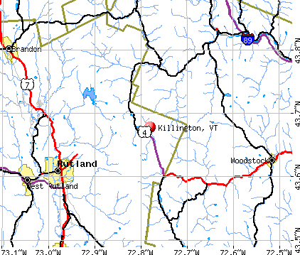
- OSM Map
- General Map
- Google Map
- MSN Map
Population change since 2000: -25.9%
| Males: 439 | |
| Females: 372 |
| Median resident age: | 47.8 years |
| Vermont median age: | 45.8 years |
Zip codes: 05751.
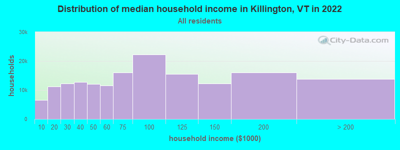
| Killington: | $80,955 |
| VT: | $73,991 |
Estimated per capita income in 2022: $63,455 (it was $32,066 in 2000)
Killington town income, earnings, and wages data
Estimated median house or condo value in 2022: $458,071 (it was $195,600 in 2000)
| Killington: | $458,071 |
| VT: | $304,700 |
Mean prices in 2022: all housing units: $254,868; detached houses: $264,391; townhouses or other attached units: $230,842; in 2-unit structures: $224,848; in 3-to-4-unit structures: $273,008; in 5-or-more-unit structures: $159,824; mobile homes: $117,051
Detailed information about poverty and poor residents in Killington, VT

Compare current foreclosures near Killington, VT:
| Photo | Address | Area | Beds / Baths | Price | Details |
|---|---|---|---|---|---|

|
#1
Doe Hill Way
Woodstock, VT 05091
|
1,264 sq. feet
|
1 baths 1 beds |
$262,900
|
show details |

|
#2
Mt Hunger Rd
Stockbridge, VT 05772
|
- sq. feet
|
2 baths 3 beds |
$410,800
|
show details |

|
#3
Pine St # 5
Rutland, VT 05701
|
- sq. feet
|
- baths - beds |
show details | |

|
#4
Dartt Hill Rd, # Po122
Bethel, VT 05032
|
- sq. feet
|
- baths - beds |
show details | |

|
#5
Columbian Ave Apt 2
Rutland, VT 05701
|
- sq. feet
|
- baths - beds |
show details | |

|
#6
1/2 State St, # 2
Rutland, VT 05701
|
- sq. feet
|
- baths - beds |
show details | |

|
#7
Dillon Rd
Ludlow, VT 05149
|
- sq. feet
|
- baths - beds |
show details | |

|
#8
Knipes Dr
North Clarendon, VT 05759
|
- sq. feet
|
- baths - beds |
show details | |

|
#9
Evergreen Ave
Rutland, VT 05701
|
- sq. feet
|
- baths - beds |
show details | |

|
#10
Geno Rd
Bridgewater Corners, VT 05035
|
- sq. feet
|
- baths - beds |
show details |
| Photo | Address | Area | Beds / Baths | Price | Details |
|---|---|---|---|---|---|

|
#11
Library Ave
Rutland, VT 05701
|
- sq. feet
|
- baths - beds |
show details | |

|
#12
1/2 Kingsley Ave
Rutland, VT 05701
|
- sq. feet
|
- baths - beds |
show details | |

|
#13
Davis St
Rutland, VT 05701
|
- sq. feet
|
- baths - beds |
show details | |

|
#14
Bellevue Ave
Rutland, VT 05701
|
- sq. feet
|
- baths - beds |
show details | |

|
#15
Commons St # C
Rutland, VT 05701
|
- sq. feet
|
- baths - beds |
show details | |

|
#16
Eastview Ct
Rutland, VT 05701
|
- sq. feet
|
- baths - beds |
show details | |

|
#17
Ccc Rd
Cuttingsville, VT 05738
|
- sq. feet
|
- baths - beds |
show details | |

|
#18
Stratton Rd
Rutland, VT 05701
|
- sq. feet
|
- baths - beds |
show details | |

|
#19
Sawyer Hill Rd
Mount Holly, VT 05758
|
- sq. feet
|
- baths - beds |
show details | |

|
Check over 1 million property listings on Foreclosure.com!
|
browse all offers | |||

- 76994.8%White alone
- 131.6%Hispanic
- 91.1%Asian alone
- 81.0%Two or more races
- 60.7%Other race alone
- 50.6%American Indian alone
- 10.1%Black alone
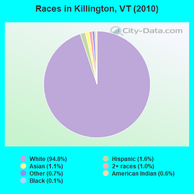
Races in Killington detailed stats: ancestries, foreign born residents, place of birth
According to our research of Vermont and other state lists, there were 3 registered sex offenders living in Killington, Vermont as of June 16, 2024.
The ratio of all residents to sex offenders in Killington is 270 to 1.
Type |
2014 |
2015 |
2016 |
2017 |
2018 |
2019 |
2020 |
2021 |
2022 |
|---|---|---|---|---|---|---|---|---|---|
| Murders (per 100,000) | 0 (0.0) | 0 (0.0) | 0 (0.0) | 0 (0.0) | 0 (0.0) | 0 (0.0) | 0 (0.0) | 0 (0.0) | 0 (0.0) |
| Rapes (per 100,000) | 0 (0.0) | 0 (0.0) | 0 (0.0) | 0 (0.0) | 0 (0.0) | 0 (0.0) | 0 (0.0) | 0 (0.0) | 0 (0.0) |
| Robberies (per 100,000) | 0 (0.0) | 0 (0.0) | 0 (0.0) | 0 (0.0) | 0 (0.0) | 0 (0.0) | 0 (0.0) | 0 (0.0) | 0 (0.0) |
| Assaults (per 100,000) | 0 (0.0) | 0 (0.0) | 0 (0.0) | 0 (0.0) | 0 (0.0) | 0 (0.0) | 0 (0.0) | 0 (0.0) | 4 (282.9) |
| Burglaries (per 100,000) | 0 (0.0) | 3 (379.3) | 1 (127.2) | 2 (257.4) | 4 (522.9) | 0 (0.0) | 0 (0.0) | 0 (0.0) | 0 (0.0) |
| Thefts (per 100,000) | 1 (124.7) | 6 (758.5) | 7 (890.6) | 11 (1,416) | 5 (653.6) | 2 (264.2) | 3 (400.0) | 5 (672.9) | 3 (212.2) |
| Auto thefts (per 100,000) | 0 (0.0) | 0 (0.0) | 0 (0.0) | 0 (0.0) | 0 (0.0) | 0 (0.0) | 0 (0.0) | 0 (0.0) | 1 (70.7) |
| Arson (per 100,000) | 0 (0.0) | 0 (0.0) | 0 (0.0) | 0 (0.0) | 0 (0.0) | 0 (0.0) | 0 (0.0) | 0 (0.0) | 0 (0.0) |
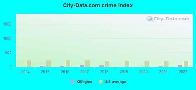
| City-Data.com crime index | 5.0 | 56.9 | 44.5 | 74.6 | 62.7 | 10.6 | 16.0 | 26.9 | 70.7 |
The City-Data.com crime index weighs serious crimes and violent crimes more heavily. Higher means more crime, U.S. average is 246.1. It adjusts for the number of visitors and daily workers commuting into cities.
Crime rate in Killington detailed stats: murders, rapes, robberies, assaults, burglaries, thefts, arson
Full-time law enforcement employees in 2021, including police officers: 2 (2 officers - 2 male; 0 female).
| Officers per 1,000 residents here: | 2.69 |
| Vermont average: | 1.69 |
 Recent articles from our blog. Our writers, many of them Ph.D. graduates or candidates, create easy-to-read articles on a wide variety of topics.


Latest news from Killington, VT collected exclusively by city-data.com from local newspapers, TV, and radio stations
Ancestries: Irish (18.0%), German (17.6%), English (14.1%), Italian (10.7%), Polish (6.6%), French Canadian (6.0%).
Current Local Time: EST time zone
Land area: 46.6 square miles.
Population density: 17 people per square mile (very low).
56 residents are foreign born (2.9% Europe, 1.0% Asia, 0.8% North America).
| This town: | 5.1% |
| Vermont: | 3.8% |
| Killington town: | 1.0% ($2,029) |
| Vermont: | 2.0% ($2,196) |
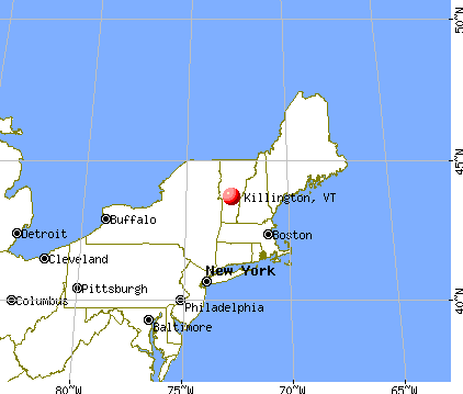
Nearest city with pop. 50,000+: Manchester, NH  (82.2 miles , pop. 107,006).
Nearest city with pop. 200,000+: Boston, MA (126.7 miles , pop. 589,141).
Nearest city with pop. 1,000,000+: Bronx, NY (202.6 miles , pop. 1,332,650).
Nearest cities:
), ), ), )Latitude: 43.66 N, Longitude: 72.79 W
Area code commonly used in this area: 802

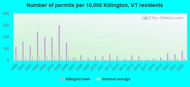
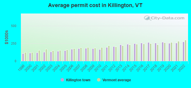
Single-family new house construction building permits:
- 2022: 9 buildings, average cost: $277,000
- 2021: 6 buildings, average cost: $257,400
- 2020: 7 buildings, average cost: $253,000
- 2019: 3 buildings, average cost: $271,400
- 2018: 2 buildings, average cost: $258,800
- 2017: 1 building, cost: $267,800
- 2016: 4 buildings, average cost: $256,700
- 2015: 5 buildings, average cost: $248,000
- 2014: 2 buildings, average cost: $241,400
- 2013: 4 buildings, average cost: $233,900
- 2012: 6 buildings, average cost: $207,600
- 2011: 4 buildings, average cost: $196,600
- 2010: 4 buildings, average cost: $165,900
- 2009: 3 buildings, average cost: $178,900
- 2008: 5 buildings, average cost: $182,400
- 2007: 3 buildings, average cost: $181,200
- 2006: 17 buildings, average cost: $168,600
- 2005: 33 buildings, average cost: $148,800
- 2004: 22 buildings, average cost: $139,900
- 2003: 22 buildings, average cost: $131,900
- 2002: 27 buildings, average cost: $130,000
- 2001: 14 buildings, average cost: $121,400
- 2000: 18 buildings, average cost: $117,000
- 1999: 13 buildings, average cost: $109,200
| Here: | 2.1% |
| Vermont: | 2.0% |
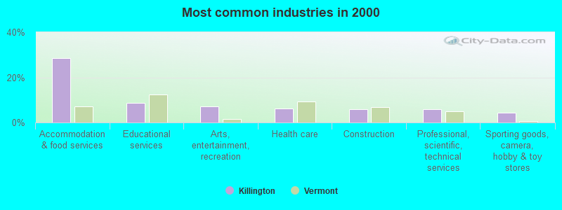
- Accommodation & food services (28.6%)
- Educational services (8.8%)
- Arts, entertainment, recreation (7.2%)
- Health care (6.2%)
- Construction (5.9%)
- Professional, scientific, technical services (5.9%)
- Sporting goods, camera, hobby & toy stores (4.4%)
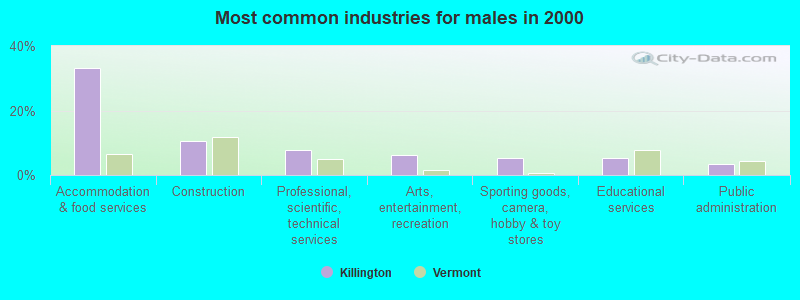
- Accommodation & food services (33.1%)
- Construction (10.5%)
- Professional, scientific, technical services (7.9%)
- Arts, entertainment, recreation (6.3%)
- Sporting goods, camera, hobby & toy stores (5.2%)
- Educational services (5.2%)
- Public administration (3.4%)
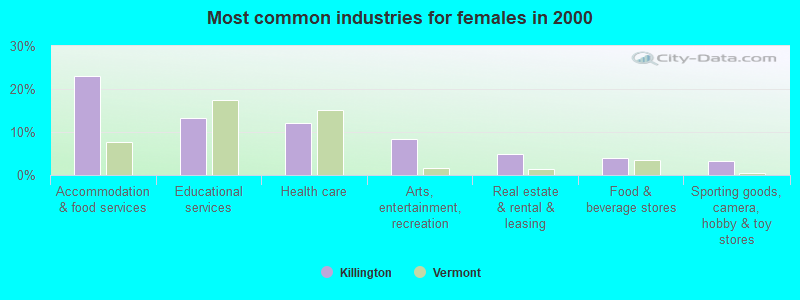
- Accommodation & food services (23.0%)
- Educational services (13.3%)
- Health care (12.0%)
- Arts, entertainment, recreation (8.3%)
- Real estate & rental & leasing (5.0%)
- Food & beverage stores (4.0%)
- Sporting goods, camera, hobby & toy stores (3.3%)
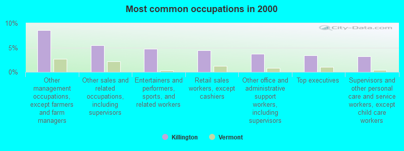
- Other management occupations, except farmers and farm managers (8.5%)
- Other sales and related occupations, including supervisors (5.4%)
- Entertainers and performers, sports, and related workers (4.7%)
- Retail sales workers, except cashiers (4.4%)
- Other office and administrative support workers, including supervisors (3.7%)
- Top executives (3.4%)
- Supervisors and other personal care and service workers, except child care workers (3.2%)
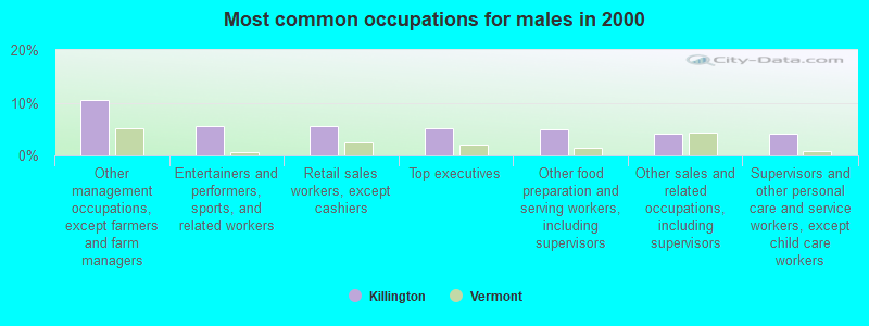
- Other management occupations, except farmers and farm managers (10.5%)
- Entertainers and performers, sports, and related workers (5.5%)
- Retail sales workers, except cashiers (5.5%)
- Top executives (5.2%)
- Other food preparation and serving workers, including supervisors (5.0%)
- Other sales and related occupations, including supervisors (4.2%)
- Supervisors and other personal care and service workers, except child care workers (4.2%)
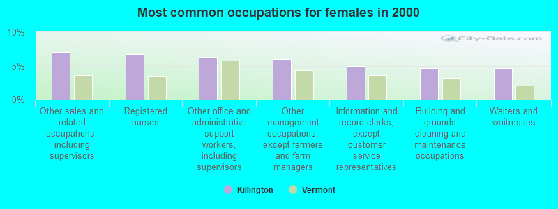
- Other sales and related occupations, including supervisors (7.0%)
- Registered nurses (6.7%)
- Other office and administrative support workers, including supervisors (6.3%)
- Other management occupations, except farmers and farm managers (6.0%)
- Information and record clerks, except customer service representatives (5.0%)
- Building and grounds cleaning and maintenance occupations (4.7%)
- Waiters and waitresses (4.7%)
Average climate in Killington, Vermont
Based on data reported by over 4,000 weather stations


(lower is better)
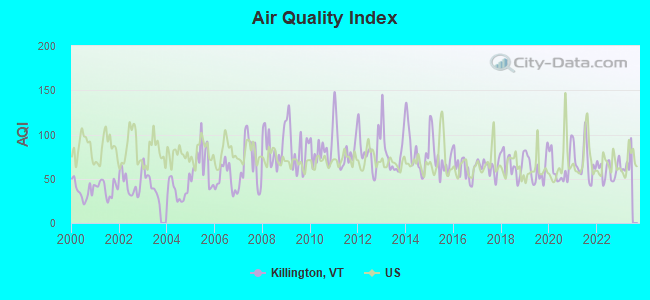
Air Quality Index (AQI) level in 2022 was 59.9. This is better than average.
| City: | 59.9 |
| U.S.: | 72.6 |

Carbon Monoxide (CO) [ppm] level in 2022 was 0.251. This is about average. Closest monitor was 10.3 miles away from the city center.
| City: | 0.251 |
| U.S.: | 0.251 |
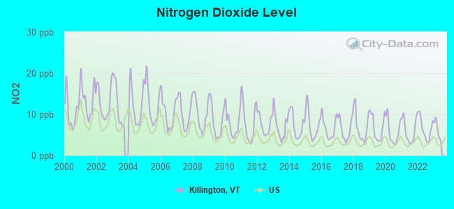
Nitrogen Dioxide (NO2) [ppb] level in 2022 was 6.51. This is worse than average. Closest monitor was 10.3 miles away from the city center.
| City: | 6.51 |
| U.S.: | 5.11 |
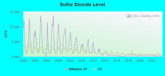
Sulfur Dioxide (SO2) [ppb] level in 2022 was 0.299. This is significantly better than average. Closest monitor was 10.2 miles away from the city center.
| City: | 0.299 |
| U.S.: | 1.515 |
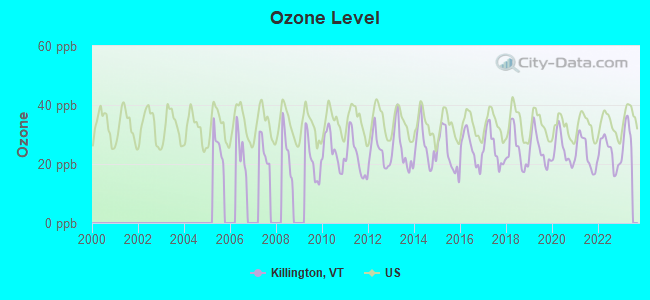
Ozone [ppb] level in 2022 was 23.8. This is better than average. Closest monitor was 10.3 miles away from the city center.
| City: | 23.8 |
| U.S.: | 33.3 |
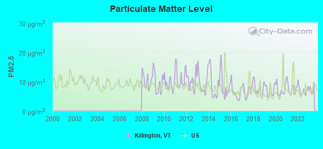
Particulate Matter (PM2.5) [µg/m3] level in 2022 was 6.98. This is about average. Closest monitor was 10.3 miles away from the city center.
| City: | 6.98 |
| U.S.: | 8.11 |
Tornado activity:
Killington-area historical tornado activity is near Vermont state average. It is 71% smaller than the overall U.S. average.
On 8/20/1968, a category F3 (max. wind speeds 158-206 mph) tornado 39.1 miles away from the Killington town center injured one person and caused between $5000 and $50,000 in damages.
On 10/24/1955, a category F2 (max. wind speeds 113-157 mph) tornado 25.1 miles away from the town center caused between $5000 and $50,000 in damages.
Earthquake activity:
Killington-area historical earthquake activity is significantly above Vermont state average. It is 70% smaller than the overall U.S. average.On 4/20/2002 at 10:50:47, a magnitude 5.3 (5.3 ML, Depth: 3.0 mi, Class: Moderate, Intensity: VI - VII) earthquake occurred 73.8 miles away from Killington center
On 10/7/1983 at 10:18:46, a magnitude 5.3 (5.1 MB, 5.3 LG, 5.1 ML) earthquake occurred 79.8 miles away from Killington center
On 4/20/2002 at 10:50:47, a magnitude 5.2 (5.2 MB, 4.2 MS, 5.2 MW, 5.0 MW) earthquake occurred 73.1 miles away from Killington center
On 1/19/1982 at 00:14:42, a magnitude 4.7 (4.5 MB, 4.7 MD, 4.5 LG, Class: Light, Intensity: IV - V) earthquake occurred 60.9 miles away from the city center
On 10/16/2012 at 23:12:25, a magnitude 4.7 (4.7 ML, Depth: 10.0 mi) earthquake occurred 107.1 miles away from the city center
On 6/17/1991 at 08:53:16, a magnitude 4.1 (4.0 MB, 4.0 LG, Depth: 3.1 mi) earthquake occurred 119.0 miles away from the city center
Magnitude types: regional Lg-wave magnitude (LG), body-wave magnitude (MB), duration magnitude (MD), local magnitude (ML), surface-wave magnitude (MS), moment magnitude (MW)
Natural disasters:
The number of natural disasters in Rutland County (16) is near the US average (15).Major Disasters (Presidential) Declared: 11
Emergencies Declared: 2
Causes of natural disasters: Floods: 9, Storms: 9, Tropical Storms: 2, Winter Storms: 2, Hurricane: 1, Landslide: 1, Snowstorm: 1, Wind: 1, Other: 1 (Note: some incidents may be assigned to more than one category).

Hospitals and medical centers near Killington:
- WESTVIEW COURT (Hospital, about 10 miles away; RUTLAND, VT)
- RUTLAND AREA VNA (Home Health Center, about 10 miles away; RUTLAND, VT)
- MOUNTAIN VIEW CENTER GENESIS HEALTHCARE (Nursing Home, about 10 miles away; RUTLAND, VT)
- FLETCHER ALLEN HEALTHCARE - RRMC SATELLITE (Dialysis Facility, about 10 miles away; RUTLAND, VT)
- RUTLAND REGIONAL MEDICAL CENTER Acute Care Hospitals (about 10 miles away; RUTLAND, VT)
- RUTLAND HEALTHCARE AND REHABILITATION CENTER (Nursing Home, about 10 miles away; RUTLAND, VT)
- THE PINES AT RUTLAND CENTER FOR NURSING AND REHABI (Nursing Home, about 10 miles away; RUTLAND, VT)
Heliports located in Killington:
Colleges/universities with over 2000 students nearest to Killington:
- Castleton State College (about 20 miles; Castleton, VT; Full-time enrollment: 2,079)
- Dartmouth College (about 26 miles; Hanover, NH; FT enrollment: 6,030)
- Middlebury College (about 31 miles; Middlebury, VT; FT enrollment: 3,077)
- Norwich University (about 34 miles; Northfield, VT; FT enrollment: 4,221)
- Adirondack Community College (about 49 miles; Queensbury, NY; FT enrollment: 2,826)
- Plymouth State University (about 56 miles; Plymouth, NH; FT enrollment: 4,838)
- Keene State College (about 58 miles; Keene, NH; FT enrollment: 5,098)
Private high school in Killington:
Points of interest:
Notable locations in Killington: Green Mountain Golf Course (A), Killington Ski Area (B), Pico Peak Ski Area (C), Colony Club (D), Killington Basin Ski Center (E), Killington Golf Course (F), Pico Peak Winter Sprorts Area (G), Pico Trail Shelter (H), Mountain Meadows Ski Touring Center (I), Sherburne Town Hall (J), Killington Fire And Rescue Station 2 (K), Killington Fire And Rescue Station 1 (L), Sherburne Volunteer Fire Department (M). Display/hide their locations on the map
Churches in Killington include: Sherburne Church of Christ (A), Mission Chapel (B). Display/hide their locations on the map
Cemeteries: Church of Our Saviour Cemetery (1), Anthony Family Cemetery (2), Hillside Cemetery (3), Riverside Cemetery (4), Wood-Clement Episcopal Cemetery (5). Display/hide their locations on the map
Lakes and reservoirs: Pico Pond (A), Kent Pond (B), Colton Pond (C). Display/hide their locations on the map
Streams, rivers, and creeks: Taylor Brook (A), Shaw Hill Brook (B), Brimstone Brook (C), Roaring Brook (D), Quimby Brook (E), Middle Brook (F), Windfall Brook (G), Kent Brook (H), Falls Brook (I). Display/hide their locations on the map
Parks in Killington include: Gifford Woods Natural Area (1), Giffords Woods State Forest Park (2), Lew Newall Wildlife Management Area (3), Valley Park (4). Display/hide their locations on the map
Hotels: Sunrise Village Condominiums (Bear Mountain Road) (1), New Life Spa Fitness (Killington Road) (2), MTK Plumbing & Heating (104 Miller Brook Road) (3), Mendon Mountain View Resort (78 US Route 4) (4), Jason's Restaurant at the Red Rob Inn (2708 Killington Road) (5), Butternut on the Mountain (Box 306) (6), Sherburne-Killington Motel (1946 Route 4 East) (7), Killington Grand Resort Hotel & Conference Center (228 East Mountain Rd) (8), Comfort Inn Killington (905 Killington Road) (9). Display/hide their approximate locations on the map
Drinking water stations with addresses in Killington and their reported violations in the past:
MOUNTAIN GREEN CONDOMINIUM (Address: 135 EAST MOUNTAIN RD , Population served: 1,300, Groundwater):Past health violations:KILLINGTON UPLAND WATER CO INC (Address: 4763 KILLINGTON RD , Population served: 518, Groundwater):Past monitoring violations:
- MCL, Average - Between JUL-2011 and SEP-2011, Contaminant: Combined Radium (-226 and -228). Follow-up actions: St Public Notif requested (JAN-27-2012), St Formal NOV issued (JAN-27-2012), St Tech Assistance Visit (JAN-27-2012), St Public Notif received (FEB-16-2012), St Compliance achieved (2 times from MAR-14-2014 to MAR-20-2014)
- MCL, Average - Between OCT-2010 and DEC-2010, Contaminant: Combined Radium (-226 and -228). Follow-up actions: St Public Notif requested (JAN-25-2011), St Formal NOV issued (JAN-25-2011), St Tech Assistance Visit (JAN-25-2011), St Public Notif received (FEB-22-2011), St Compliance achieved (MAR-14-2014)
- MCL, Average - Between JUL-2010 and SEP-2010, Contaminant: Combined Radium (-226 and -228). Follow-up actions: St Formal NOV issued (OCT-20-2010), St Public Notif requested (OCT-20-2010), St Tech Assistance Visit (OCT-20-2010), St Public Notif received (NOV-16-2010), St Compliance achieved (MAR-14-2014)
- MCL, Average - Between APR-2010 and JUN-2010, Contaminant: Combined Radium (-226 and -228). Follow-up actions: St Public Notif requested (JUL-14-2010), St Formal NOV issued (JUL-14-2010), St Tech Assistance Visit (JUL-14-2010), St Public Notif received (JUL-22-2010), St Compliance achieved (MAR-14-2014)
- MCL, Average - Between JAN-2010 and MAR-2010, Contaminant: Combined Radium (-226 and -228). Follow-up actions: St Public Notif requested (APR-08-2010), St Tech Assistance Visit (APR-08-2010), St Formal NOV issued (APR-08-2010), St Public Notif received (MAY-13-2010), St Compliance achieved (MAR-14-2014)
- MCL, Average - Between OCT-2009 and DEC-2009, Contaminant: Combined Radium (-226 and -228). Follow-up actions: St Public Notif requested (NOV-19-2009), St Tech Assistance Visit (NOV-19-2009), St Formal NOV issued (NOV-19-2009), St Public Notif received (DEC-03-2009), St Compliance achieved (MAR-14-2014)
- 2 other older health violations
- Monitoring and Reporting (DBP) - Between OCT-2010 and DEC-2010, Contaminant: Chlorine. Follow-up actions: St Public Notif requested (JAN-20-2011), St Formal NOV issued (JAN-20-2011), St Public Notif received (FEB-22-2011), St Compliance achieved (NOV-07-2011)
- Monitoring and Reporting (DBP) - Between APR-2008 and JUN-2008, Contaminant: Chlorine. Follow-up actions: St Public Notif requested (JAN-15-2009), St Formal NOV issued (JAN-15-2009), St Public Notif received (JUN-24-2009), St Compliance achieved (NOV-08-2010)
- Monitoring and Reporting (DBP) - Between JAN-2008 and MAR-2008, Contaminant: Chlorine. Follow-up actions: St Public Notif requested (JUL-22-2008), St Formal NOV issued (JUL-22-2008), St Public Notif received (JUN-24-2009), St Compliance achieved (NOV-08-2010)
- One routine major monitoring violation
- 160 regular monitoring violations
Past monitoring violations:MOUNTAIN INN (Address: 47 OLD MILL RD , Population served: 362, Groundwater):
- 2 routine major monitoring violations
Past health violations:CASCADES LODGE (Address: 58 OLD MILL RD , Population served: 304, Groundwater):Past monitoring violations:
- MCL, Monthly (TCR) - In MAR-2008, Contaminant: Coliform. Follow-up actions: St Tech Assistance Visit (MAR-14-2008), St Formal NOV issued (MAR-14-2008), St Boil Water Order (MAR-14-2008), St Public Notif requested (MAR-14-2008), St Public Notif received (MAR-27-2008), St Compliance achieved (SEP-25-2009)
- MCL, Monthly (TCR) - Between JUL-2005 and SEP-2005, Contaminant: Coliform. Follow-up actions: St Tech Assistance Visit (SEP-21-2005), St Boil Water Order (SEP-21-2005), St Violation/Reminder Notice (SEP-21-2005), St Public Notif requested (SEP-21-2005), St Public Notif received (SEP-27-2005), St Compliance achieved (JAN-29-2010)
- One regular monitoring violation
Past monitoring violations:KILLINGTON UPPER ADMINISTRATION BLDG (Address: 4763 KILLINGTON RD , Population served: 284, Groundwater):
- One routine major monitoring violation
Past health violations:WOBBLY BARN (Address: 4763 KILLINGTON RD , Population served: 225, Groundwater):Past monitoring violations:
- MCL, Monthly (TCR) - In JUL-2013, Contaminant: Coliform. Follow-up actions: St Tech Assistance Visit (JUL-25-2013), St Formal NOV issued (JUL-25-2013), St Public Notif requested (JUL-25-2013), St Boil Water Order (JUL-25-2013), St Compliance achieved (AUG-01-2013)
- One routine major monitoring violation
- 21 regular monitoring violations
Past health violations:TRAIL CREEK CONDOMINIUM (Population served: 212, Groundwater):
- MCL, Monthly (TCR) - In NOV-2011, Contaminant: Coliform. Follow-up actions: St Compliance achieved (NOV-18-2011), St Public Notif requested (NOV-22-2011), St Tech Assistance Visit (NOV-22-2011), St Boil Water Order (NOV-22-2011), St Formal NOV issued (NOV-22-2011)
- MCL, Monthly (TCR) - Between JUL-2006 and SEP-2006, Contaminant: Coliform. Follow-up actions: St Tech Assistance Visit (OCT-23-2006), St Boil Water Order (OCT-23-2006), St Formal NOV issued (OCT-23-2006), St Public Notif requested (OCT-23-2006), St Public Notif received (OCT-25-2006), St Compliance achieved (SEP-25-2009)
Past health violations:NORTH STAR LODGE (Address: 78 WEATHERVANE DR , Population served: 210, Groundwater):Past monitoring violations:
- Public Education - In APR-01-2011, Contaminant: Lead and Copper Rule. Follow-up actions: St Formal NOV issued (APR-27-2011), St Compliance achieved (JUN-01-2011)
- MCL, Monthly (TCR) - In JAN-2008, Contaminant: Coliform. Follow-up actions: St Tech Assistance Visit (FEB-01-2008), St Formal NOV issued (FEB-01-2008), St Boil Water Order (FEB-01-2008), St Public Notif requested (FEB-01-2008), St Public Notif received (FEB-06-2008), St Compliance achieved (AUG-20-2010)
- Initial Tap Sampling for Pb and Cu - In JAN-01-2012, Contaminant: Lead and Copper Rule. Follow-up actions: St Formal NOV issued (MAR-09-2012), St Tech Assistance Visit (MAR-09-2012), St Public Notif requested (MAR-09-2012), St Public Notif received (JUN-22-2012)
- 7 routine major monitoring violations
- One minor monitoring violation
- 45 regular monitoring violations
Past health violations:Past monitoring violations:
- MCL, Monthly (TCR) - Between JUL-2010 and SEP-2010, Contaminant: Coliform. Follow-up actions: St Tech Assistance Visit (JUL-13-2010), St Formal NOV issued (JUL-13-2010), St Public Notif requested (JUL-13-2010), St Boil Water Order (JUL-13-2010), St Compliance achieved (NOV-09-2011)
- MCL, Monthly (TCR) - In JUN-2009, Contaminant: Coliform. Follow-up actions: St Tech Assistance Visit (JUN-11-2009), St Formal NOV issued (JUN-11-2009), St Public Notif requested (JUN-11-2009), St Boil Water Order (JUN-11-2009), St Compliance achieved (NOV-04-2010)
- MCL, Monthly (TCR) - In DEC-2008, Contaminant: Coliform. Follow-up actions: St Tech Assistance Visit (DEC-22-2008), St Formal NOV issued (DEC-22-2008), St Public Notif requested (DEC-22-2008), St Boil Water Order (DEC-22-2008), St Compliance achieved (NOV-04-2010)
- 11 routine major monitoring violations
- 3 regular monitoring violations
Drinking water stations with addresses in Killington that have no violations reported:
- RAMSHEAD LODGESNOWSHED BASE LODGE (Address: 4763 KILLINGTON RD , Population served: 1,600, Primary Water Source Type: Groundwater)
- KILLINGTON BASE LODGE (Address: 4763 KILLINGTON RD , Population served: 1,425, Primary Water Source Type: Groundwater)
- BEAR MOUNTAIN (Address: 4763 KILLINGTON RD , Population served: 767, Primary Water Source Type: Groundwater)
- FORT DUMMER STATE PARK (Address: 515 RTE 100 , Population served: 244, Primary Water Source Type: Groundwater)
- CALVIN COOLIDGE STATE PARK (Address: 515 RTE 100 , Population served: 242, Primary Water Source Type: Groundwater)
- JAMAICA STATE PARK (Address: 515 RTE 100 , Population served: 242, Primary Water Source Type: Groundwater)
- ASCUTNEY STATE PARK (Address: 515 RTE 100 , Population served: 200, Primary Water Source Type: Groundwater)
- VERMONT SILVER LAKE STATE PARK (Address: 515 RTE 100 , Population served: 194, Primary Water Source Type: Groundwater)
- CHALET KILLINGTON (Population served: 180, Primary Water Source Type: Groundwater)
- SKYESHIP BASE LODGE (Address: 4763 KILLINGTON RD , Population served: 156, Primary Water Source Type: Groundwater)
| This town: | 2.0 people |
| Vermont: | 2.3 people |
| This town: | 48.5% |
| Whole state: | 62.5% |
| This town: | 8.2% |
| Whole state: | 9.2% |
Likely homosexual households (counted as self-reported same-sex unmarried-partner households)
- Lesbian couples: 0.0% of all households
- Gay men: 0.3% of all households
| This town: | 7.0% |
| Whole state: | 9.4% |
| This town: | 2.6% |
| Whole state: | 3.6% |
6 people in workers' group living quarters and job corps centers in 2010
For population 15 years and over in Killington:
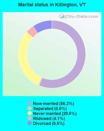
- Never married: 29.6%
- Now married: 56.3%
- Separated: 0.5%
- Widowed: 4.1%
- Divorced: 9.5%
For population 25 years and over in Killington:
- High school or higher: 95.8%
- Bachelor's degree or higher: 48.7%
- Graduate or professional degree: 15.7%
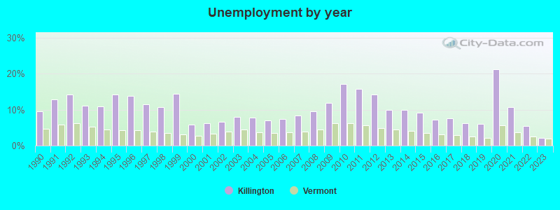
- Unemployed: 3.7%
- Mean travel time to work (commute): 19.9 minutes
| Here: | 9.3 |
| Vermont average: | 11.7 |
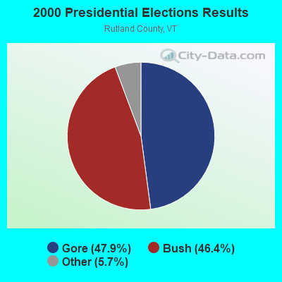
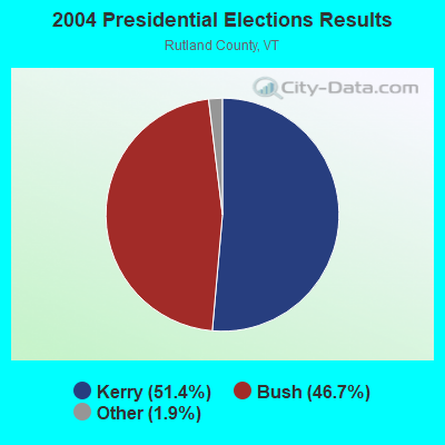
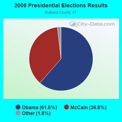
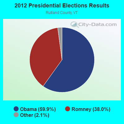


Graphs represent county-level data. Detailed 2008 Election Results
Religion statistics for Killington, VT (based on Rutland County data)

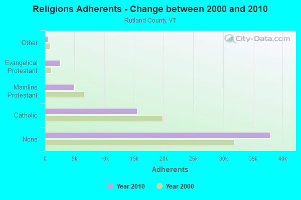
| Religion | Adherents | Congregations |
|---|---|---|
| Catholic | 15,500 | 17 |
| Mainline Protestant | 4,944 | 38 |
| Evangelical Protestant | 2,587 | 36 |
| Other | 520 | 5 |
| Orthodox | 85 | 1 |
| None | 38,006 | - |
Food Environment Statistics:
| Rutland County: | 3.78 / 10,000 pop. |
| Vermont: | 3.84 / 10,000 pop. |
| Rutland County: | 2.05 / 10,000 pop. |
| Vermont: | 1.95 / 10,000 pop. |
| This county: | 7.56 / 10,000 pop. |
| Vermont: | 6.40 / 10,000 pop. |
| This county: | 12.77 / 10,000 pop. |
| Vermont: | 11.52 / 10,000 pop. |
| Rutland County: | 7.8% |
| Vermont: | 6.8% |
| Here: | 24.1% |
| Vermont: | 22.3% |
| Rutland County: | 18.5% |
| Vermont: | 13.3% |
| Businesses in Killington, VT | ||||
| Name | Count | Name | Count | |
|---|---|---|---|---|
| Comfort Inn | 1 | Nike | 1 | |
| FedEx | 1 | True Value | 1 | |
| MasterBrand Cabinets | 4 | UPS | 1 | |
Strongest AM radio stations in Killington:
- WSYB (1380 AM; 5 kW; RUTLAND, VT; Owner: CAPSTAR TX LIMITED PARTNERSHIP)
- WGY (810 AM; 50 kW; SCHENECTADY, NY; Owner: CLEAR CHANNEL BROADCASTING LICENSES, INC.)
- WNTK (1020 AM; 10 kW; NEWPORT, NH; Owner: KOOR COMMUNICATIONS, INC.)
- WNNZ (640 AM; 50 kW; WESTFIELD, MA; Owner: CLEAR CHANNEL BROADCASTING LICENSES, INC.)
- WRKO (680 AM; 50 kW; BOSTON, MA; Owner: ENTERCOM BOSTON LICENSE, LLC)
- WCRN (830 AM; 50 kW; WORCESTER, MA; Owner: CARTER BROADCASTING CORPORATION)
- WCHP (760 AM; 35 kW; CHAMPLAIN, NY; Owner: CHAMPLAIN RADIO, INC.)
- WPTR (1540 AM; 50 kW; ALBANY, NY; Owner: KIMTRON, INC.)
- WEEI (850 AM; 50 kW; BOSTON, MA; Owner: ENTERCOM BOSTON LICENSE, LLC)
- WDEV (550 AM; 5 kW; WATERBURY, VT; Owner: RADIO VERMONT, INC.)
- WNBX (1480 AM; 5 kW; SPRINGFIELD, VT)
- WKOX (1200 AM; 50 kW; FRAMINGHAM, MA; Owner: CAPSTAR TX LIMITED PARTNERSHIP)
- WVNE (760 AM; daytime; 25 kW; LEICESTER, MA; Owner: BLOUNT MASSCOM, INC.)
Strongest FM radio stations in Killington:
- WEBK (105.3 FM; KILLINGTON, VT; Owner: 6 JOHNSON ROAD LICENSES, INC.)
- WGLV (91.7 FM; WOODSTOCK, VT; Owner: CHRISTIAN MINISTRIES INC)
- WHDQ-FM1 (106.1 FM; RUTLAND, VT; Owner: GREAT NORTHERN RADIO, L.L.C.)
- WJJR (98.1 FM; RUTLAND, VT; Owner: 6 JOHNSON ROAD LICENSES, INC.)
- WZRT (97.1 FM; RUTLAND, VT; Owner: CAPSTAR TX LIMITED PARTNERSHIP)
- WJEN (94.5 FM; RUTLAND, VT; Owner: 6 JOHNSON ROAD LICENSES, INC.)
- WVPR (89.5 FM; WINDSOR, VT; Owner: VERMONT PUBLIC RADIO)
- WEXP (101.5 FM; BRANDON, VT; Owner: VOX VERMONT, L.L.C.)
- WHDQ (106.1 FM; CLAREMONT, NH; Owner: GREAT NORTHERN RADIO, L.L.C.)
- WDEV-FM (96.1 FM; WARREN, VT; Owner: RADIO VERMONT, INC.)
- WEQX (102.7 FM; MANCHESTER, VT; Owner: NORTHSHIRE COMMUNICATIONS, INC.)
- WJAN (95.1 FM; SUNDERLAND, VT; Owner: 6 JOHNSON ROAD LICENSES, INC.)
- WMXR (93.9 FM; WOODSTOCK, VT; Owner: CLEAR CHANNEL BROADCASTING LICENSES, INC.)
- WCVT (101.7 FM; STOWE, VT; Owner: RADIO VERMONT CLASSICS, L.L.C.)
- WEVH (91.3 FM; HANOVER, NH; Owner: NEW HAMPSHIRE PUBLIC RADIO INC)
- WRJT (103.1 FM; ROYALTON, VT; Owner: LISBON COMMUNICATIONS, INC.)
- WVPS (107.9 FM; BURLINGTON, VT; Owner: VERMONT PUBLIC RADIO)
- WEZF (92.9 FM; BURLINGTON, VT; Owner: CAPSTAR TX LIMITED PARTNERSHIP)
- WVRR (101.7 FM; NEWPORT, NH; Owner: CAPSTAR TX LIMITED PARTNERSHIP)
- WLKC (103.3 FM; WATERBURY, VT; Owner: RADIO BROADCASTING SERVICES, INC.)
TV broadcast stations around Killington:
- W63AD (Channel 63; RUTLAND, VT; Owner: C-22 FCC LICENSEE SUBSIDIARY, LLC)
- W07AG (Channel 7; RUTLAND, VT; Owner: WNYT INC.)
- WVER (Channel 28; RUTLAND, VT; Owner: VERMONT ETV, INC.)
- W18AE (Channel 18; KILLINGTON, VT; Owner: KILLINGTON, LTD.)
- W69AR (Channel 69; RUTLAND, VT; Owner: MT. MANSFIELD TELEVISION, INC.)
- W61CE (Channel 61; RUTLAND, VT; Owner: MARGARET SANGUINETTI (ADMINISTRATRIX OF THE ESTATE))
- WVTA (Channel 41; WINDSOR, VT; Owner: VERMONT ETV, INC.)
- WNNE (Channel 31; HARTFORD, VT; Owner: HEARST-ARGYLE STATIONS, INC.)
- Killington, Vermont
- Fatal accident count14
- Vehicles involved in fatal accidents21
- Fatal accidents involving drunk persons:5
- Fatalities16
- Persons involved in fatal accidents38
- Pedestrians involved in fatal accidents2
- Vermont average
- Fatal accident count726
- Vehicles involved in fatal accidents1045
- Fatal accidents involving drunk persons252
- Fatalities812
- Persons involved in fatal accidents1636
- Pedestrians involved in fatal accidents77
FCC Registered Cell Phone Towers:
1- 4567 Killington Rd (102947) (Lat: 43.639083 Lon: -72.836194), Type: Ltower, Structure height: 18.6 m, Overall height: 22.6 m, Call Sign: KNKN749
Assigned Frequencies: 869.040 MHz, 869.040 MHz, 869.040 MHz, 824.040 MHz, 824.040 MHz, 824.040 MHz, 890.010 MHz, 890.010 MHz, 890.010 MHz, 845.010 MHz, 845.010 MHz, 845.010 MHzGrant Date: 09/01/2020, Expiration Date: 10/01/2030, Certifier: Michael P GogginRegistrant: At&t Services, Inc., 208 S Akard St, 20f, Dallas, TX 75202, Phone: (855) 699-7073, Fax: (214) 746-6410, Email:
FCC Registered Broadcast Land Mobile Towers:
8 (See the full list of FCC Registered Broadcast Land Mobile Towers in Killington, VT)FCC Registered Microwave Towers:
8 (See the full list of FCC Registered Microwave Towers in this town)FCC Registered Amateur Radio Licenses:
10 (See the full list of FCC Registered Amateur Radio Licenses in Killington)FAA Registered Aircraft:
2- Aircraft: GRUMMAN AMERICAN AVN. CORP. AA-5B (Category: Land, Seats: 4, Weight: Up to 12,499 Pounds, Speed: 105 mph), Engine: LYCOMING O&VO-360 SER (180 HP) (Reciprocating)
N-Number: 28296, N28296, N-28296, Serial Number: AA5B0534, Year manufactured: 1977, Airworthiness Date: 06/28/1977
Registrant (Individual): Pending Registration, Po Box 953, Killington, VT 05751 - Aircraft: BACON ROGER D QUESTAIR #20 VENTURE (Category: Land, Seats: 2, Weight: Up to 12,499 Pounds), Engine: CONT MOTOR IO-550 SERIES (300 HP) (Reciprocating)
N-Number: 8KX, N8KX, N-8KX, Serial Number: 37, Year manufactured: 1992, Airworthiness Date: 08/26/2013, Certificate Issue Date: 06/16/2006
Registrant (Individual): Jeremiah J Weeks, 371 Round Robin Rd, Killington, VT 05751
2002 - 2018 National Fire Incident Reporting System (NFIRS) incidents
- Fire incident types reported to NFIRS in Killington, VT
- 15259.1%Structure Fires
- 4116.0%Outside Fires
- 3413.2%Other
- 3011.7%Mobile Property/Vehicle Fires
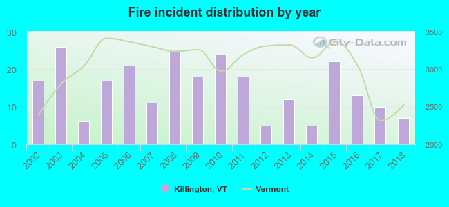 According to the data from the years 2002 - 2018 the average number of fire incidents per year is 15. The highest number of fires - 26 took place in 2003, and the least - 5 in 2012. The data has a decreasing trend.
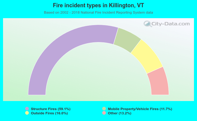 When looking into fire subcategories, the most reports belonged to: Structure Fires (59.1%), and Outside Fires (16.0%).
Fire-safe hotels and motels in Killington, Vermont:
- Mountain Sports Inn, 813 Killington Rd, Killington, Vermont 05751 , Phone: (802) 422-3315, Fax: (802) 422-5126
- The Cascades Lodge & Restaurant, 58 Old Mill Rd, Killington, Vermont 05751 , Phone: (802) 422-3731, Fax: (802) 422-3351
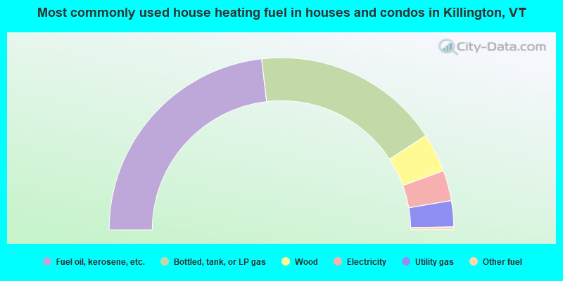
- 46.3%Fuel oil, kerosene, etc.
- 35.2%Bottled, tank, or LP gas
- 7.3%Wood
- 5.7%Electricity
- 4.9%Utility gas
- 0.5%Other fuel
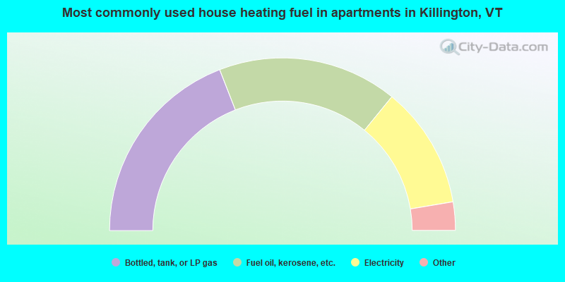
- 38.2%Bottled, tank, or LP gas
- 33.6%Fuel oil, kerosene, etc.
- 22.9%Electricity
- 3.1%Wood
- 2.3%Utility gas
Killington compared to Vermont state average:
- Median house value above state average.
- Unemployed percentage significantly below state average.
- Black race population percentage significantly below state average.
- Hispanic race population percentage below state average.
- Length of stay since moving in significantly above state average.
- Number of rooms per house significantly below state average.
- House age significantly below state average.
- Percentage of population with a bachelor's degree or higher above state average.
Killington on our top lists:
- #94 on the list of "Top 100 cities with strongest arts, entertainment, recreation, accommodation and food services industries"
- #12 on the list of "Top 101 counties with the highest percentage of residents that smoked 100+ cigarettes in their lives"
- #14 on the list of "Top 101 counties with the highest percentage of residents that keep firearms around their homes"
- #55 on the list of "Top 101 counties with the lowest average weight of females"
- #57 on the list of "Top 101 counties with the highest Sulfur Oxides Annual air pollution readings in 2012 (µg/m3)"
- #58 on the list of "Top 101 counties with the largest increase in the number of deaths per 1000 residents 2000-2006 to 2007-2013 (pop. 50,000+)"

|
Total of 2 patent applications in 2008-2024.