Landaff, New Hampshire
Submit your own pictures of this town and show them to the world
- OSM Map
- Google Map
- MSN Map
Population change since 2000: +9.8%
 |
| Males: 197 | |
| Females: 218 |
| Median resident age: | 50.1 years |
| New Hampshire median age: | 43.9 years |
Zip codes: 03585.
| Landaff: | $82,049 |
| NH: | $89,992 |
Estimated per capita income in 2022: $41,007 (it was $18,033 in 2000)
Landaff town income, earnings, and wages data
Estimated median house or condo value in 2022: $304,920 (it was $95,400 in 2000)
| Landaff: | $304,920 |
| NH: | $384,700 |
Mean prices in 2022: all housing units: $486,096; detached houses: $533,852; townhouses or other attached units: $375,744; in 2-unit structures: $230,260; in 3-to-4-unit structures: $242,363; in 5-or-more-unit structures: $588,257; mobile homes: $127,035
Detailed information about poverty and poor residents in Landaff, NH
Compare current foreclosures near Landaff, NH:
| Photo | Address | Area | Beds / Baths | Price | Details |
|---|---|---|---|---|---|

|
#1
Scott Hwy
Groton, VT 05046
|
- sq. feet
|
2 baths 3 beds |
$142,500
|
show details |

|
#2
Bishop Rd
Lisbon, NH 03585
|
- sq. feet
|
1 baths 3 beds |
show details | |

|
#3
Sugar Hill Rd
Franconia, NH 03580
|
- sq. feet
|
- baths - beds |
show details | |

|
#4
Mountain View Dr
Monroe, NH 03771
|
- sq. feet
|
- baths - beds |
show details | |

|
#5
Depot St
Haverhill, NH 03765
|
- sq. feet
|
- baths - beds |
show details | |

|
#6
Wallace Hill Rd
Wells River, VT 05081
|
- sq. feet
|
- baths - beds |
show details | |

|
#7
Maciver Rd
Littleton, NH 03561
|
- sq. feet
|
- baths - beds |
show details | |

|
#8
Washington St
Littleton, NH 03561
|
- sq. feet
|
- baths - beds |
show details | |

|
#9
Eastside Rd
North Woodstock, NH 03262
|
- sq. feet
|
- baths - beds |
show details | |

|
Check over 1 million property listings on Foreclosure.com!
|
browse all offers | |||

- 39795.7%White alone
- 92.2%Two or more races
- 51.2%Asian alone
- 20.5%Black alone
- 10.2%Other race alone
- 10.2%Hispanic

Races in Landaff detailed stats: ancestries, foreign born residents, place of birth
 Recent articles from our blog. Our writers, many of them Ph.D. graduates or candidates, create easy-to-read articles on a wide variety of topics.
Ancestries: English (36.5%), French (29.4%), United States (12.4%), Irish (11.1%), Scottish (9.3%), Italian (7.1%).
Current Local Time: EST time zone
Incorporated in 1774
Land area: 28.4 square miles.
Population density: 15 people per square mile (very low).
9 residents are foreign born (1.9% Europe, 0.5% North America).
| This town: | 2.4% |
| New Hampshire: | 4.4% |
| Landaff town: | 1.2% ($1,190) |
| New Hampshire: | 2.3% ($2,946) |
Nearest city with pop. 50,000+: Manchester, NH  (84.0 miles , pop. 107,006).
Nearest city with pop. 200,000+: Boston, MA (133.3 miles , pop. 589,141).
Nearest city with pop. 1,000,000+: Bronx, NY (250.5 miles , pop. 1,332,650).
Nearest cities:
), ), )Latitude: 44.16 N, Longitude: 71.89 W
Area code commonly used in this area: 603

| Here: | 2.1% |
| New Hampshire: | 2.5% |


- Metal & metal products (17.0%)
- Educational services (12.1%)
- Furniture & related product manufacturing (7.3%)
- Public administration (6.3%)
- Health care (5.8%)
- Construction (4.9%)
- Agriculture, forestry, fishing & hunting (4.4%)

- Metal & metal products (21.3%)
- Furniture & related product manufacturing (10.2%)
- Construction (9.3%)
- Agriculture, forestry, fishing & hunting (8.3%)
- Public administration (8.3%)
- Educational services (6.5%)
- Chemicals (4.6%)

- Educational services (18.4%)
- Metal & metal products (12.2%)
- Health care (10.2%)
- Used merchandise, gift, novelty, souvenir, other miscellaneous stores (7.1%)
- Food & beverage stores (6.1%)
- Administrative & support & waste management services (6.1%)
- Furniture & related product manufacturing (4.1%)

- Other production occupations, including supervisors (12.1%)
- Other office and administrative support workers, including supervisors (5.8%)
- Building and grounds cleaning and maintenance occupations (5.3%)
- Preschool, kindergarten, elementary, and middle school teachers (4.9%)
- Teachers, secondary school (4.9%)
- Material recording, scheduling, dispatching, and distributing workers (4.4%)
- Other sales and related occupations, including supervisors (4.4%)

- Other production occupations, including supervisors (10.2%)
- Material recording, scheduling, dispatching, and distributing workers (8.3%)
- Driver/sales workers and truck drivers (5.6%)
- Building and grounds cleaning and maintenance occupations (5.6%)
- Electrical equipment mechanics and other installation, maintenance, and repair workers, including supervisors (5.6%)
- Other management occupations, except farmers and farm managers (4.6%)
- Teachers, secondary school (4.6%)

- Other production occupations, including supervisors (14.3%)
- Other office and administrative support workers, including supervisors (10.2%)
- Preschool, kindergarten, elementary, and middle school teachers (8.2%)
- Cashiers (7.1%)
- Bookkeeping, accounting, and auditing clerks (7.1%)
- Other sales and related occupations, including supervisors (6.1%)
- Teachers, secondary school (5.1%)
Average climate in Landaff, New Hampshire
Based on data reported by over 4,000 weather stations


(lower is better)

Air Quality Index (AQI) level in 2021 was 39.8. This is significantly better than average.
| City: | 39.8 |
| U.S.: | 72.6 |

Ozone [ppb] level in 2021 was 25.7. This is better than average. Closest monitor was 8.1 miles away from the city center.
| City: | 25.7 |
| U.S.: | 33.3 |
Earthquake activity:
Landaff-area historical earthquake activity is significantly above New Hampshire state average. It is 72% smaller than the overall U.S. average.On 4/20/2002 at 10:50:47, a magnitude 5.3 (5.3 ML, Depth: 3.0 mi, Class: Moderate, Intensity: VI - VII) earthquake occurred 92.9 miles away from Landaff center
On 4/20/2002 at 10:50:47, a magnitude 5.2 (5.2 MB, 4.2 MS, 5.2 MW, 5.0 MW) earthquake occurred 93.5 miles away from Landaff center
On 10/7/1983 at 10:18:46, a magnitude 5.3 (5.1 MB, 5.3 LG, 5.1 ML) earthquake occurred 122.9 miles away from the city center
On 1/19/1982 at 00:14:42, a magnitude 4.7 (4.5 MB, 4.7 MD, 4.5 LG, Class: Light, Intensity: IV - V) earthquake occurred 47.8 miles away from the city center
On 10/16/2012 at 23:12:25, a magnitude 4.7 (4.7 ML, Depth: 10.0 mi) earthquake occurred 72.6 miles away from Landaff center
On 6/16/1995 at 12:13:11, a magnitude 3.8 (3.8 LG, Depth: 3.1 mi, Class: Light, Intensity: II - III) earthquake occurred 8.9 miles away from Landaff center
Magnitude types: regional Lg-wave magnitude (LG), body-wave magnitude (MB), duration magnitude (MD), local magnitude (ML), surface-wave magnitude (MS), moment magnitude (MW)
Natural disasters:
The number of natural disasters in Grafton County (32) is a lot greater than the US average (15).Major Disasters (Presidential) Declared: 20
Emergencies Declared: 9
Causes of natural disasters: Floods: 16, Storms: 16, Hurricanes: 3, Snows: 3, Winter Storms: 3, Tropical Storms: 2, Blizzard: 1, Heavy Rain: 1, Ice Storm: 1, Landslide: 1, Snowfall: 1, Snowstorm: 1, Wind: 1, Other: 1 (Note: some incidents may be assigned to more than one category).
Hospitals and medical centers near Landaff:
- COTTAGE HOSPITAL Critical Access Hospitals (about 5 miles away; WOODSVILLE, NH)
- LAFAYETTE CENTER, GENESIS HEALTHCARE (Nursing Home, about 9 miles away; FRANCONIA, NH)
- GRAFTON COUNTY NURSING HOME (Nursing Home, about 9 miles away; NORTH HAVERHILL, NH)
- NORTH COUNTRY HOME HEALTH AND HOSPICE AGENCY (Home Health Center, about 11 miles away; LITTLETON, NH)
- GLENCLIFF HOME FOR THE ELDERLY (Nursing Home, about 12 miles away; GLENCLIFF, NH)
Colleges/universities with over 2000 students nearest to Landaff:
- Plymouth State University (about 30 miles; Plymouth, NH; Full-time enrollment: 4,838)
- Dartmouth College (about 38 miles; Hanover, NH; FT enrollment: 6,030)
- Norwich University (about 39 miles; Northfield, VT; FT enrollment: 4,221)
- Middlebury College (about 65 miles; Middlebury, VT; FT enrollment: 3,077)
- NHTI-Concord's Community College (about 68 miles; Concord, NH; FT enrollment: 2,865)
- Saint Michael's College (about 68 miles; Colchester, VT; FT enrollment: 2,336)
- Community College of Vermont (about 69 miles; Winooski, VT; FT enrollment: 3,394)
Public elementary/middle school in Landaff:
- LANDAFF BLUE SCHOOL (Students: 17, Location: 813 MILLBROOK RD., Grades: PK-3)
Points of interest:
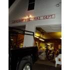
Notable locations in Landaff: Ammonoosuc Fish and Game Club (A), Landaff Volunteer Fire Department (B). Display/hide their locations on the map
Church in Landaff: Center Hill Church (A). Display/hide its location on the map
Cemetery: Center Hill Cemetery (1). Display/hide its location on the map
Lakes and reservoirs: Chandler Pond (A), Gordon Pond (B), Chandler Pond (C). Display/hide their locations on the map
Streams, rivers, and creeks: Whitcher Brook (A), Dearth Brook (B), Davis Brook (C), Mill Brook (D). Display/hide their locations on the map
| This town: | 2.3 people |
| New Hampshire: | 2.5 people |
| This town: | 74.3% |
| Whole state: | 66.3% |
| This town: | 6.1% |
| Whole state: | 8.3% |
Likely homosexual households (counted as self-reported same-sex unmarried-partner households)
- Lesbian couples: 0.6% of all households
- Gay men: 0.0% of all households
| This town: | 7.1% |
| Whole state: | 6.5% |
| This town: | 1.0% |
| Whole state: | 2.8% |
For population 15 years and over in Landaff:

- Never married: 20.6%
- Now married: 63.3%
- Separated: 0.0%
- Widowed: 7.3%
- Divorced: 8.9%
For population 25 years and over in Landaff:
- High school or higher: 82.9%
- Bachelor's degree or higher: 24.2%
- Graduate or professional degree: 9.7%
- Unemployed: 4.2%
- Mean travel time to work (commute): 21.5 minutes


| Here: | 11.4 |
| New Hampshire average: | 10.9 |


Graphs represent county-level data. Detailed 2008 Election Results
Religion statistics for Landaff, NH (based on Grafton County data)


| Religion | Adherents | Congregations |
|---|---|---|
| Catholic | 9,503 | 12 |
| Mainline Protestant | 7,832 | 57 |
| Evangelical Protestant | 1,494 | 29 |
| Other | 1,320 | 11 |
| None | 68,969 | - |
Food Environment Statistics:
| This county: | 3.87 / 10,000 pop. |
| New Hampshire: | 2.14 / 10,000 pop. |
| Grafton County: | 0.23 / 10,000 pop. |
| State: | 0.15 / 10,000 pop. |
| Grafton County: | 1.29 / 10,000 pop. |
| New Hampshire: | 1.78 / 10,000 pop. |
| This county: | 6.45 / 10,000 pop. |
| State: | 4.02 / 10,000 pop. |
| Grafton County: | 14.41 / 10,000 pop. |
| New Hampshire: | 9.70 / 10,000 pop. |
| This county: | 7.2% |
| New Hampshire: | 7.6% |
| This county: | 22.9% |
| State: | 24.4% |
| Grafton County: | 15.9% |
| New Hampshire: | 15.9% |
Strongest AM radio stations in Landaff:
- WTWN (1100 AM; daytime; 5 kW; WELLS RIVER, VT; Owner: PUFFER BROADCASTING, INC.)
- WCHP (760 AM; 35 kW; CHAMPLAIN, NY; Owner: CHAMPLAIN RADIO, INC.)
- WPNH (1300 AM; 5 kW; PLYMOUTH, NH; Owner: NORTHEAST COMMUNICATIONS CORPORATION)
- WLTN (1400 AM; 1 kW; LITTLETON, NH; Owner: PROFILE BROADCASTING COMPANY, INC.)
- WRKO (680 AM; 50 kW; BOSTON, MA; Owner: ENTERCOM BOSTON LICENSE, LLC)
- WDEV (550 AM; 5 kW; WATERBURY, VT; Owner: RADIO VERMONT, INC.)
- WNNZ (640 AM; 50 kW; WESTFIELD, MA; Owner: CLEAR CHANNEL BROADCASTING LICENSES, INC.)
- WCRN (830 AM; 50 kW; WORCESTER, MA; Owner: CARTER BROADCASTING CORPORATION)
- WEEI (850 AM; 50 kW; BOSTON, MA; Owner: ENTERCOM BOSTON LICENSE, LLC)
- WNTK (1020 AM; 10 kW; NEWPORT, NH; Owner: KOOR COMMUNICATIONS, INC.)
- WGY (810 AM; 50 kW; SCHENECTADY, NY; Owner: CLEAR CHANNEL BROADCASTING LICENSES, INC.)
- WBZ (1030 AM; 50 kW; BOSTON, MA; Owner: INFINITY BROADCASTING OPERATIONS, INC.)
- WKOX (1200 AM; 50 kW; FRAMINGHAM, MA; Owner: CAPSTAR TX LIMITED PARTNERSHIP)
Strongest FM radio stations in Landaff:
- WLTN-FM (96.7 FM; LISBON, NH; Owner: PROFILE BROADCASTING CO., INC.)
- WPKQ (103.7 FM; NORTH CONWAY, NH; Owner: CITADEL BROADCASTING COMPANY)
- WHOM (94.9 FM; MT. WASHINGTON, NH; Owner: CITADEL BROADCASTING COMPANY)
- WVFM (105.7 FM; CAMPTON, NH; Owner: DEVON BROADCASTING COMPANY, INC.)
- WMTK (106.3 FM; LITTLETON, NH; Owner: VERMONT BROADCAST ASSOCIATES, INC.)
- WYKR-FM (101.3 FM; HAVERHILL, NH; Owner: PUFFER BROADCASTING, INC.)
- WGMT (97.7 FM; LYNDON, VT; Owner: VERMONT BROADCAST ASSOCIATES, INC.)
- WDOT (95.7 FM; DANVILLE, VT; Owner: MONTPELIER BROADCASTING INC)
- WXXS (102.3 FM; LANCASTER, NH; Owner: BARRY P. LUNDERVILLE)
- WSCY (106.9 FM; MOULTONBOROUGH, NH; Owner: NORTHEAST COMMUNICATIONS CORPORATION)
- WCKJ (90.5 FM; ST. JOHNSBURY, VT; Owner: CHRISTIAN MINISTRIES, INC.)
- WKXH (105.5 FM; ST. JOHNSBURY, VT; Owner: VERMONT BROADCAST ASSOCIATES, INC.)
- WCVT (101.7 FM; STOWE, VT; Owner: RADIO VERMONT CLASSICS, L.L.C.)
- WPNH-FM (100.1 FM; PLYMOUTH, NH; Owner: NORTHEAST COMMUNICATIONS CORPORATION)
- WLKC (103.3 FM; WATERBURY, VT; Owner: RADIO BROADCASTING SERVICES, INC.)
- WVPS (107.9 FM; BURLINGTON, VT; Owner: VERMONT PUBLIC RADIO)
- WEZF (92.9 FM; BURLINGTON, VT; Owner: CAPSTAR TX LIMITED PARTNERSHIP)
- WDEV-FM (96.1 FM; WARREN, VT; Owner: RADIO VERMONT, INC.)
- WNCS (104.7 FM; MONTPELIER, VT; Owner: MONTPELIER BROADCASTING, INC.)
- WEVH (91.3 FM; HANOVER, NH; Owner: NEW HAMPSHIRE PUBLIC RADIO INC)
TV broadcast stations around Landaff:
- WLED-TV (Channel 49; LITTLETON, NH; Owner: UNIVERSITY OF NEW HAMPSHIRE)
- WMUR-LP (Channel 29; LITTLETON, NH; Owner: HEARST-ARGYLE PROPERTIES, INC.)
- W38CB (Channel 38; LITTLETON, NH; Owner: HEARST-ARGYLE PROPERTIES, INC.)
- National Bridge Inventory (NBI) Statistics
- 7Number of bridges
- 23ft / 7.3mTotal length
- $21,994,000Total costs
- 5,883Total average daily traffic
- 383Total average daily truck traffic
- 8,704Total future (year 2042) average daily traffic
FCC Registered Amateur Radio Licenses:
1- Call Sign: KC1IHW, Licensee ID: L02137425, Grant Date: 10/20/2017, Expiration Date: 10/20/2027, Certifier: Arthur E Blodgett Jr, Registrant: Arthur E Blodgett Jr, 851 Jericho Trail, Landaff, NH 03585

- 66.9%Fuel oil, kerosene, etc.
- 15.8%Wood
- 12.8%Bottled, tank, or LP gas
- 2.3%Electricity
- 2.3%Coal or coke

- 50.0%Fuel oil, kerosene, etc.
- 33.3%Bottled, tank, or LP gas
- 16.7%Wood
Landaff compared to New Hampshire state average:
- Unemployed percentage below state average.
- Black race population percentage below state average.
- Hispanic race population percentage significantly below state average.
- Median age above state average.
- Foreign-born population percentage significantly below state average.
- Renting percentage below state average.
- Length of stay since moving in significantly above state average.
- Number of rooms per house significantly below state average.
- House age significantly below state average.