Magnolia-Upton, Kentucky
Submit your own pictures of this place and show them to the world
- OSM Map
- Google Map
- MSN Map
| Males: 1,834 | |
| Females: 1,851 |
| Median resident age: | 37.7 years |
| Kentucky median age: | 35.9 years |
Zip code: 42748
| Magnolia-Upton: | $54,366 |
| KY: | $59,341 |
Estimated per capita income in 2022: $28,452 (it was $15,879 in 2000)
Magnolia-Upton CCD income, earnings, and wages data
Estimated median house or condo value in 2022: $171,299 (it was $69,600 in 2000)
| Magnolia-Upton: | $171,299 |
| KY: | $196,300 |
Mean prices in 2022: all housing units: $211,662; detached houses: $224,860; townhouses or other attached units: $180,710; mobile homes: $103,039
Magnolia-Upton, KY residents, houses, and apartments details
Detailed information about poverty and poor residents in Magnolia-Upton, KY


- 3,50496.3%White alone
- 441.2%Black alone
- 421.2%Two or more races
- 320.9%Hispanic
- 90.2%American Indian alone
- 30.08%Native Hawaiian and Other
Pacific Islander alone - 20.05%Other race alone
- 10.03%Asian alone

Races in Magnolia-Upton detailed stats: ancestries, foreign born residents, place of birth
 Recent articles from our blog. Our writers, many of them Ph.D. graduates or candidates, create easy-to-read articles on a wide variety of topics.
Current Local Time: EST time zone
Land area: 82.2 square miles.
Population density: 45 people per square mile (very low).
| Magnolia-Upton CCD: | 0.5% ($348) |
| Kentucky: | 0.8% ($610) |
Nearest city with pop. 50,000+: Louisville, KY  (52.5 miles , pop. 256,231).
Nearest city with pop. 1,000,000+: Chicago, IL (318.6 miles , pop. 2,896,016).
Nearest cities:
), ), ), ), ), )Latitude: 37.47 N, Longitude: 85.78 W
Area code commonly used in this area: 270

| Here: | 4.0% |
| Kentucky: | 3.8% |

- Construction (8.0%)
- Agriculture, forestry, fishing & hunting (7.0%)
- Health care (6.8%)
- Educational services (6.8%)
- Public administration (4.8%)
- Transportation equipment (4.7%)
- Apparel (3.0%)

- Construction (13.2%)
- Agriculture, forestry, fishing & hunting (11.6%)
- Transportation equipment (7.2%)
- Public administration (4.9%)
- Repair & maintenance (4.1%)
- Metal & metal products (4.0%)
- Truck transportation (3.9%)

- Educational services (12.8%)
- Health care (11.8%)
- Apparel (6.7%)
- Finance & insurance (6.3%)
- Social assistance (5.5%)
- Public administration (4.7%)
- U. S. Postal service (4.5%)

- Building and grounds cleaning and maintenance occupations (5.3%)
- Material recording, scheduling, dispatching, and distributing workers (5.2%)
- Farmers and farm managers (5.0%)
- Metal workers and plastic workers (4.9%)
- Driver/sales workers and truck drivers (3.8%)
- Vehicle and mobile equipment mechanics, installers, and repairers (3.6%)
- Other production occupations, including supervisors (3.6%)

- Farmers and farm managers (8.0%)
- Metal workers and plastic workers (7.2%)
- Driver/sales workers and truck drivers (6.8%)
- Vehicle and mobile equipment mechanics, installers, and repairers (6.4%)
- Electrical equipment mechanics and other installation, maintenance, and repair workers, including supervisors (5.4%)
- Assemblers and fabricators (4.3%)
- Other sales and related occupations, including supervisors (4.3%)

- Material recording, scheduling, dispatching, and distributing workers (8.7%)
- Textile, apparel, and furnishings workers (6.9%)
- Building and grounds cleaning and maintenance occupations (6.7%)
- Cashiers (6.6%)
- Secretaries and administrative assistants (5.9%)
- Other production occupations, including supervisors (4.4%)
- Preschool, kindergarten, elementary, and middle school teachers (4.0%)
Average climate in Magnolia-Upton, Kentucky
Based on data reported by over 4,000 weather stations


(lower is better)

Air Quality Index (AQI) level in 2022 was 63.2. This is about average.
| City: | 63.2 |
| U.S.: | 72.6 |


Particulate Matter (PM2.5) [µg/m3] level in 2022 was 8.02. This is about average. Closest monitor was 16.7 miles away from the city center.
| City: | 8.02 |
| U.S.: | 8.11 |
Tornado activity:
Magnolia-Upton-area historical tornado activity is slightly above Kentucky state average. It is 50% greater than the overall U.S. average.
On 4/3/1974, a category F4 (max. wind speeds 207-260 mph) tornado 18.4 miles away from the Magnolia-Upton place center killed 3 people and injured 81 people and caused between $50,000 and $500,000 in damages.
On 4/3/1974, a category F4 tornado 24.5 miles away from the place center injured 56 people and caused between $500,000 and $5,000,000 in damages.
Earthquake activity:
Magnolia-Upton-area historical earthquake activity is significantly above Kentucky state average. It is 132% greater than the overall U.S. average.On 4/18/2008 at 09:36:59, a magnitude 5.4 (5.1 MB, 4.8 MS, 5.4 MW, 5.2 MW, Class: Moderate, Intensity: VI - VII) earthquake occurred 133.2 miles away from the city center
On 7/27/1980 at 18:52:21, a magnitude 5.2 (5.1 MB, 4.7 MS, 5.0 UK, 5.2 UK) earthquake occurred 112.6 miles away from Magnolia-Upton center
On 4/18/2008 at 09:36:59, a magnitude 5.2 (5.2 MW, Depth: 8.9 mi) earthquake occurred 133.2 miles away from Magnolia-Upton center
On 6/18/2002 at 17:37:15, a magnitude 5.0 (4.3 MB, 4.6 MW, 5.0 LG) earthquake occurred 114.9 miles away from the city center
On 6/10/1987 at 23:48:54, a magnitude 5.1 (4.9 MB, 4.4 MS, 4.6 MS, 5.1 LG) earthquake occurred 147.6 miles away from Magnolia-Upton center
On 4/18/2008 at 15:14:16, a magnitude 4.8 (4.5 MB, 4.8 MW, 4.6 MW, Class: Light, Intensity: IV - V) earthquake occurred 132.3 miles away from the city center
Magnitude types: regional Lg-wave magnitude (LG), body-wave magnitude (MB), surface-wave magnitude (MS), moment magnitude (MW)
Natural disasters:
The number of natural disasters in Larue County (17) is near the US average (15).Major Disasters (Presidential) Declared: 14
Emergencies Declared: 2
Causes of natural disasters: Floods: 11, Storms: 10, Tornadoes: 4, Winter Storms: 4, Mudslides: 2, Snows: 2, Blizzard: 1, Freeze: 1, Hurricane: 1, Landslide: 1, Snowstorm: 1, Wind: 1, Other: 1 (Note: some incidents may be assigned to more than one category).
Colleges/universities with over 2000 students nearest to Magnolia-Upton:
- Elizabethtown Community and Technical College (about 17 miles; Elizabethtown, KY; Full-time enrollment: 3,762)
- Campbellsville University (about 26 miles; Campbellsville, KY; FT enrollment: 2,948)
- Lindsey Wilson College (about 37 miles; Columbia, KY; FT enrollment: 2,552)
- Western Kentucky University (about 50 miles; Bowling Green, KY; FT enrollment: 16,942)
- Southcentral Kentucky Community and Technical College (about 51 miles; Bowling Green, KY; FT enrollment: 2,794)
- University of Louisville (about 52 miles; Louisville, KY; FT enrollment: 16,640)
- Sullivan University (about 52 miles; Louisville, KY; FT enrollment: 5,129)
Points of interest:
Notable locations in Magnolia-Upton: Brooks (A), Magnolia Fire Department (B). Display/hide their locations on the map
Churches in Magnolia-Upton include: Mount Moriah Baptist Church (A), Mount Sherman Church (B), Oak Hill Church (C), Oak Hill Mission (D), Barren Run Baptist Church (E), Benningfield Chapel (F), Siberia Church (G). Display/hide their locations on the map
Cemetery: McCanless Cemetery (1). Display/hide its location on the map
Swamps: Clear Pond (A). Display/hide its location on the map
Streams, rivers, and creeks: Barren Run (A), Bayne Creek (B), Walters Creek (C), Tucker Creek (D), Chestnut Fork (E), South Fork Nolin River (F), Morrison Branch (G), Wathen Creek (H), Dye Branch (I). Display/hide their locations on the map
| This place: | 2.5 people |
| Kentucky: | 2.5 people |
| This place: | 72.9% |
| Whole state: | 66.9% |
| This place: | 6.2% |
| Whole state: | 6.4% |
Likely homosexual households (counted as self-reported same-sex unmarried-partner households)
- Lesbian couples: 0.5% of all households
- Gay men: 0.3% of all households
| This place: | 18.3% |
| Whole state: | 15.8% |
| This place: | 6.6% |
| Whole state: | 6.6% |
5 people in workers' group living quarters and job corps centers in 2010
12 people in homes for the mentally retarded in 2000
3 people in other noninstitutional group quarters in 2000
For population 15 years and over in Magnolia-Upton:

- Never married: 16.0%
- Now married: 68.2%
- Separated: 1.2%
- Widowed: 8.3%
- Divorced: 7.5%
For population 25 years and over in Magnolia-Upton:
- High school or higher: 67.5%
- Bachelor's degree or higher: 10.3%
- Graduate or professional degree: 5.9%
- Unemployed: 3.7%
- Mean travel time to work (commute): 26.7 minutes


| Here: | 14.0 |
| Kentucky average: | 13.8 |
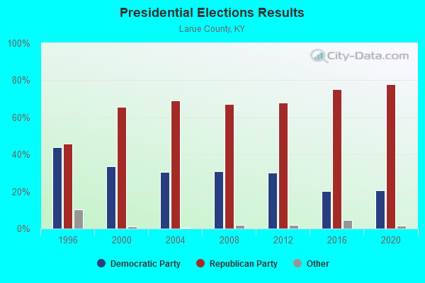
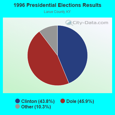
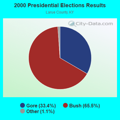

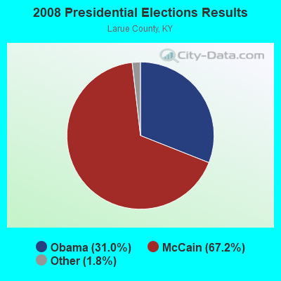

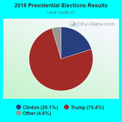
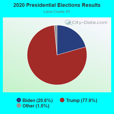
Graphs represent county-level data. Detailed 2008 Election Results
Religion statistics for Magnolia-Upton, KY (based on Larue County data)
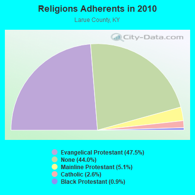
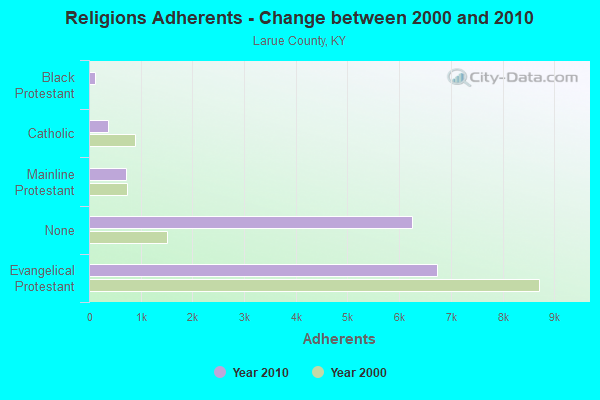
| Religion | Adherents | Congregations |
|---|---|---|
| Evangelical Protestant | 6,740 | 30 |
| Mainline Protestant | 722 | 5 |
| Catholic | 370 | 1 |
| Black Protestant | 122 | 1 |
| Other | - | - |
| None | 6,239 | - |
Food Environment Statistics:
| This county: | 2.93 / 10,000 pop. |
| Kentucky: | 2.19 / 10,000 pop. |
| Here: | 0.73 / 10,000 pop. |
| Kentucky: | 0.74 / 10,000 pop. |
| This county: | 3.66 / 10,000 pop. |
| Kentucky: | 4.36 / 10,000 pop. |
| This county: | 3.66 / 10,000 pop. |
| State: | 5.74 / 10,000 pop. |
| Larue County: | 12.0% |
| Kentucky: | 11.0% |
| Larue County: | 29.2% |
| State: | 30.0% |
| Larue County: | 17.8% |
| State: | 15.9% |
Strongest AM radio stations in Magnolia-Upton:
- WXAM (1430 AM; 1 kW; BUFFALO, KY; Owner: MARK GOODMAN PRODUCTIONS, INC.)
- WHAS (840 AM; 50 kW; LOUISVILLE, KY; Owner: CLEAR CHANNEL BROADCASTING LICENSES, INC.)
- WSM (650 AM; 50 kW; NASHVILLE, TN; Owner: GAYLORD ENTERTAINMENT COMPANY)
- WAMB (1160 AM; 50 kW; DONELSON, TN; Owner: GREAT SOUTHERN BROADCASTING COMPANY, INC.)
- WKDA (1200 AM; 50 kW; NASHVILLE, TN; Owner: RADIO NASHVILLE, INC.)
- WLOC (1150 AM; 1 kW; MUNFORDVILLE, KY; Owner: HART COUNTY COMMUNICATIONS, INC.)
- WLAC (1510 AM; 50 kW; NASHVILLE, TN; Owner: CAPSTAR TX LIMITED PARTNERSHIP)
- WNQM (1300 AM; 50 kW; NASHVILLE, TN; Owner: WNQM. INC.)
- WIEL (1400 AM; 1 kW; ELIZABETHTOWN, KY; Owner: ELIZABETHTOWN CBC, INC.)
- WKVL (850 AM; daytime; 50 kW; KNOXVILLE, TN; Owner: HORNE RADIO, LLC)
- WLW (700 AM; 50 kW; CINCINNATI, OH; Owner: JACOR BROADCASTING CORPORATION)
- WKJK (1080 AM; 10 kW; LOUISVILLE, KY; Owner: CLEAR CHANNEL BROADCASTING LICENSES, INC.)
- WKCT (930 AM; 5 kW; BOWLING GREEN, KY; Owner: DAILY NEWS BROADCASTING CO.)
Strongest FM radio stations in Magnolia-Upton:
- WASE (103.5 FM; RADCLIFF, KY; Owner: W & B BROADCASTING, INC.)
- WKUE (90.9 FM; ELIZABETHTOWN, KY; Owner: WESTERN KENTUCKY UNIVERSITY)
- WKMO (106.3 FM; HODGENVILLE, KY; Owner: ELIZABETHTOWN CBC, INC.)
- WJCR-FM (90.1 FM; UPTON, KY; Owner: FM 90.1, INC.)
- WQXE (98.3 FM; ELIZABETHTOWN, KY; Owner: SKYTOWER COMMUNICATIONS-E'TOWN, INC.)
- WLVK (105.5 FM; FORT KNOX, KY; Owner: BIG CAT BROADCASTING, INC.)
- WHHT (106.7 FM; HORSE CAVE, KY; Owner: NEWBERRY BROADCASTING, INC.)
- WCLU-FM (102.3 FM; MUNFORDVILLE, KY; Owner: ROYSE RADIO, INC)
- WTHX (107.3 FM; LEBANON JUNCTION, KY; Owner: ELIZABETHTOWN CBC, INC.)
- WGRK-FM (103.1 FM; GREENSBURG, KY; Owner: GREEN COUNTY CBC, INC.)
- WGGC (95.1 FM; GLASGOW, KY; Owner: HERITAGE COMMUNICATIONS, INC.)
- WVLC (99.9 FM; MANNSVILLE, KY; Owner: PATRICIA RODGERS)
- WCKQ (104.1 FM; CAMPBELLSVILLE, KY; Owner: CBC OF MARION & TAYLOR COUNTIES INC)
- WRZI (101.5 FM; VINE GROVE, KY; Owner: ELIZABETHTOWN CBC, INC.)
- WPTQ (103.7 FM; CAVE CITY, KY; Owner: NEWBERRY BROADCASTING, INC.)
- WKLX (100.7 FM; BROWNSVILLE, KY; Owner: CHARLES M. ANDERSON)
TV broadcast stations around Magnolia-Upton:
- WBKI-TV (Channel 34; CAMPBELLSVILLE, KY; Owner: LOUISVILLE COMMUNICATIONS, LLC)
- WKZT-TV (Channel 23; ELIZABETHTOWN, KY; Owner: KENTUCKY AUTHORITY FOR EDUCATIONAL TV)
- W39CJ (Channel 39; ELIZABETHTOWN, KY; Owner: TRINITY BROADCASTING NETWORK)
- WBKI-CA (Channel 28; LOUISVILLE, KY; Owner: LOUISVILLE COMMUNICATIONS, LLC)

- 40.5%Electricity
- 28.2%Bottled, tank, or LP gas
- 14.7%Utility gas
- 8.8%Fuel oil, kerosene, etc.
- 7.3%Wood
- 0.5%Other fuel

- 42.0%Bottled, tank, or LP gas
- 30.5%Electricity
- 12.0%Wood
- 9.0%Fuel oil, kerosene, etc.
- 6.5%Utility gas
Magnolia-Upton compared to Kentucky state average:
- Unemployed percentage significantly below state average.
- Black race population percentage significantly below state average.
- Hispanic race population percentage significantly below state average.
- Foreign-born population percentage significantly below state average.
- Renting percentage below state average.
- Length of stay since moving in significantly above state average.
- Number of rooms per house significantly below state average.
- House age significantly below state average.
- Percentage of population with a bachelor's degree or higher below state average.