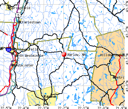
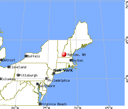
Marlow, New Hampshire
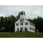
Marlow: Odd Fellows Hall, Marlow NH
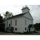
Marlow: Marlow Meeting Hall, Marlow NH
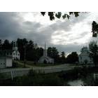
Marlow: Picturesque Marlow, New Hampshire
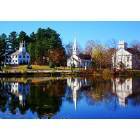
Marlow: Autumn in Marlow
- add
your
Submit your own pictures of this town and show them to the world
- OSM Map
- General Map
- Google Map
- MSN Map
Population change since 2000: -0.7%
 |
| Males: 390 | |
| Females: 352 |
| Median resident age: | 48.1 years |
| New Hampshire median age: | 43.9 years |
Zip codes: 03456.
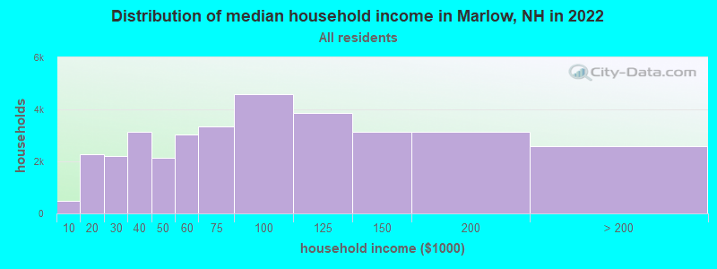
| Marlow: | $82,560 |
| NH: | $89,992 |
Estimated per capita income in 2022: $37,846 (it was $18,810 in 2000)
Marlow town income, earnings, and wages data
Estimated median house or condo value in 2022: $237,315 (it was $91,600 in 2000)
| Marlow: | $237,315 |
| NH: | $384,700 |
Mean prices in 2022: all housing units: $286,446; detached houses: $308,243; townhouses or other attached units: $255,194; in 2-unit structures: $255,554; in 3-to-4-unit structures: $346,438; in 5-or-more-unit structures: $233,006; mobile homes: $69,259
Detailed information about poverty and poor residents in Marlow, NH


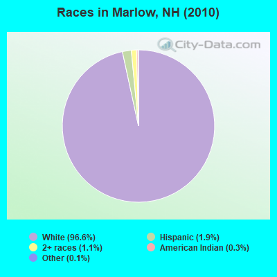
- 71796.6%White alone
- 141.9%Hispanic
- 81.1%Two or more races
- 20.3%American Indian alone
- 10.1%Other race alone
Races in Marlow detailed stats: ancestries, foreign born residents, place of birth
According to our research of New Hampshire and other state lists, there were 3 registered sex offenders living in Marlow, New Hampshire as of June 15, 2024.
The ratio of all residents to sex offenders in Marlow is 247 to 1.
 Recent articles from our blog. Our writers, many of them Ph.D. graduates or candidates, create easy-to-read articles on a wide variety of topics.

 | Good Places for Fall Pictures (10 replies) |
| Seeking information about Mason, Brookline, Hollis (3 replies) |
| Looking at Southern NH...Where would you recommend searching? (15 replies) |
| Just another day (3 replies) |
| I like the reds (8 replies) |
| need help with relocating to Marlow area (0 replies) |
Latest news from Marlow, NH collected exclusively by city-data.com from local newspapers, TV, and radio stations
Ancestries: English (15.9%), Irish (13.9%), German (13.4%), French (13.3%), United States (11.4%), Italian (5.8%).
Current Local Time: EST time zone
Incorporated in 1761
Elevation: 1158 feet
Land area: 25.9 square miles.
Population density: 29 people per square mile (very low).
17 residents are foreign born (1.5% Europe, 0.5% North America, 0.3% Latin America).
| This town: | 2.3% |
| New Hampshire: | 4.4% |
| Marlow town: | 2.7% ($2,518) |
| New Hampshire: | 2.3% ($2,946) |
Nearest city with pop. 50,000+: Manchester, NH  (39.7 miles , pop. 107,006).
Nearest city with pop. 200,000+: Boston, MA (79.4 miles , pop. 589,141).
Nearest city with pop. 1,000,000+: Bronx, NY (178.7 miles , pop. 1,332,650).
Nearest cities:
), ), ), ), ), )Latitude: 43.12 N, Longitude: 72.22 W
Area code: 603

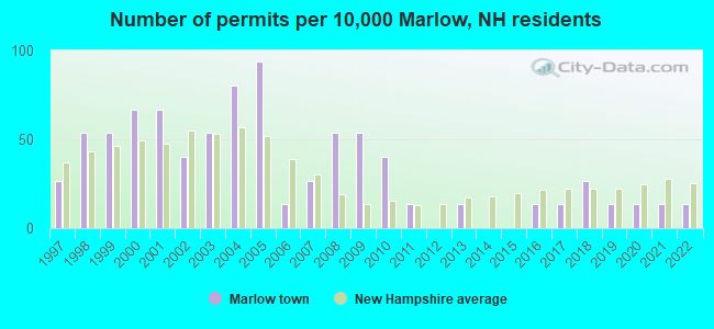
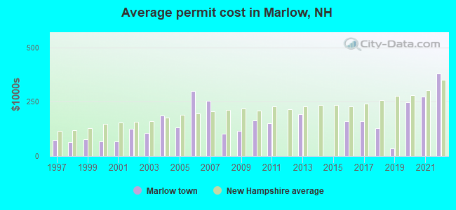
Single-family new house construction building permits:
- 2022: 1 building, cost: $380,000
- 2021: 1 building, cost: $275,000
- 2020: 1 building, cost: $248,200
- 2019: 1 building, cost: $35,000
- 2018: 2 buildings, average cost: $129,500
- 2017: 1 building, cost: $160,000
- 2016: 1 building, cost: $160,000
- 2013: 1 building, cost: $193,300
- 2011: 1 building, cost: $150,000
- 2010: 3 buildings, average cost: $165,000
- 2009: 4 buildings, average cost: $115,000
- 2008: 4 buildings, average cost: $103,300
- 2007: 2 buildings, average cost: $255,000
- 2006: 1 building, cost: $300,000
- 2005: 7 buildings, average cost: $132,100
- 2004: 6 buildings, average cost: $187,500
- 2003: 4 buildings, average cost: $106,300
- 2002: 3 buildings, average cost: $126,700
- 2001: 5 buildings, average cost: $69,200
- 2000: 5 buildings, average cost: $69,200
- 1999: 4 buildings, average cost: $75,500
- 1998: 4 buildings, average cost: $63,000
- 1997: 2 buildings, average cost: $73,500
| Here: | 4.1% |
| New Hampshire: | 2.5% |
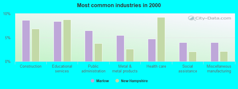
- Construction (8.7%)
- Educational services (8.4%)
- Public administration (6.4%)
- Metal & metal products (5.4%)
- Health care (4.7%)
- Social assistance (4.0%)
- Miscellaneous manufacturing (4.0%)
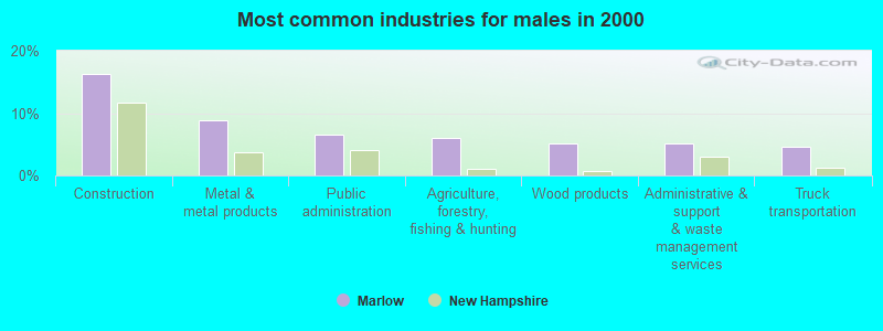
- Construction (16.2%)
- Metal & metal products (8.8%)
- Public administration (6.5%)
- Agriculture, forestry, fishing & hunting (6.0%)
- Wood products (5.1%)
- Administrative & support & waste management services (5.1%)
- Truck transportation (4.6%)
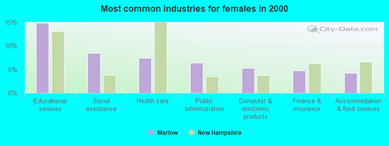
- Educational services (14.9%)
- Social assistance (8.5%)
- Health care (7.4%)
- Public administration (6.4%)
- Computer & electronic products (5.3%)
- Finance & insurance (4.8%)
- Accommodation & food services (4.3%)
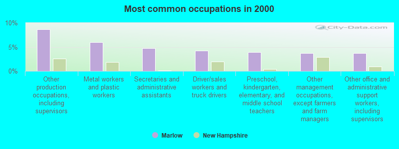
- Other production occupations, including supervisors (8.7%)
- Metal workers and plastic workers (5.9%)
- Secretaries and administrative assistants (4.7%)
- Driver/sales workers and truck drivers (4.2%)
- Preschool, kindergarten, elementary, and middle school teachers (4.0%)
- Other management occupations, except farmers and farm managers (3.7%)
- Other office and administrative support workers, including supervisors (3.7%)

- Metal workers and plastic workers (9.7%)
- Other production occupations, including supervisors (8.8%)
- Driver/sales workers and truck drivers (7.9%)
- Other management occupations, except farmers and farm managers (5.6%)
- Carpenters (4.6%)
- Computer specialists (4.2%)
- Material recording, scheduling, dispatching, and distributing workers (4.2%)
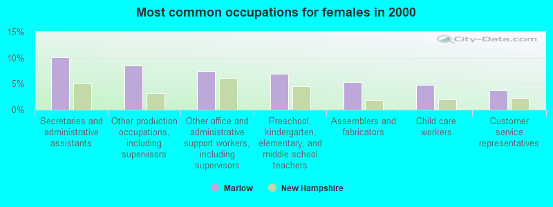
- Secretaries and administrative assistants (10.1%)
- Other production occupations, including supervisors (8.5%)
- Other office and administrative support workers, including supervisors (7.4%)
- Preschool, kindergarten, elementary, and middle school teachers (6.9%)
- Assemblers and fabricators (5.3%)
- Child care workers (4.8%)
- Customer service representatives (3.7%)
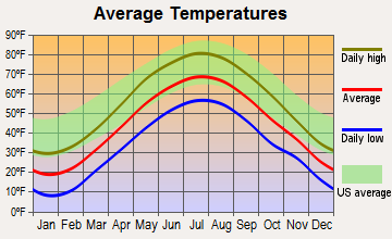
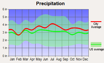
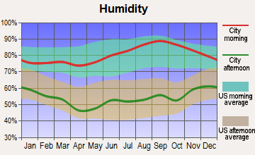
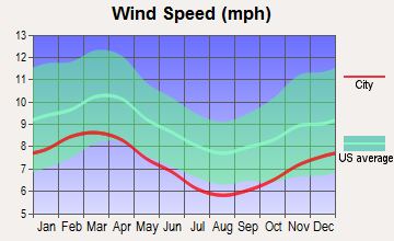
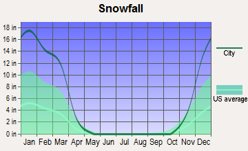
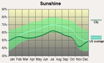
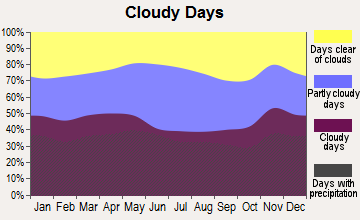
Average climate in Marlow, New Hampshire
Based on data reported by over 4,000 weather stations
(lower is better)
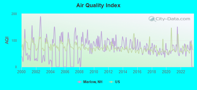
Air Quality Index (AQI) level in 2022 was 64.4. This is about average.
| City: | 64.4 |
| U.S.: | 72.6 |
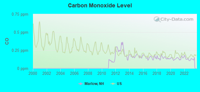
Carbon Monoxide (CO) [ppm] level in 2022 was 0.131. This is significantly better than average. Closest monitor was 13.2 miles away from the city center.
| City: | 0.131 |
| U.S.: | 0.251 |
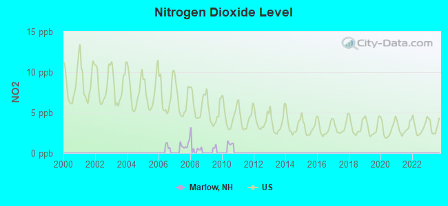
Nitrogen Dioxide (NO2) [ppb] level in 2007 was 1.02. This is significantly better than average. Closest monitor was 12.9 miles away from the city center.
| City: | 1.02 |
| U.S.: | 5.11 |
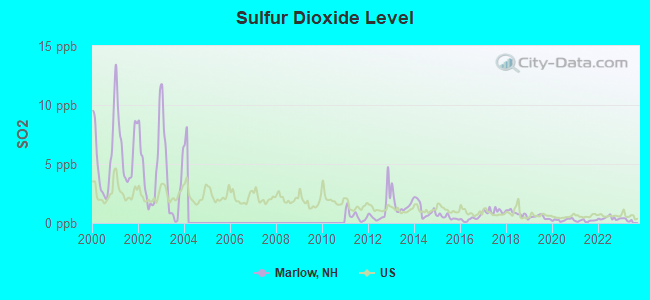
Sulfur Dioxide (SO2) [ppb] level in 2022 was 0.411. This is significantly better than average. Closest monitor was 12.9 miles away from the city center.
| City: | 0.411 |
| U.S.: | 1.515 |
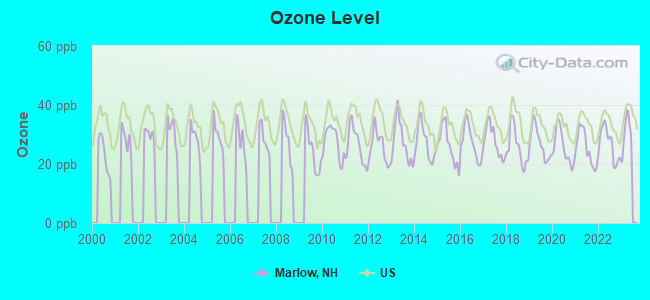
Ozone [ppb] level in 2022 was 26.8. This is better than average. Closest monitor was 12.9 miles away from the city center.
| City: | 26.8 |
| U.S.: | 33.3 |
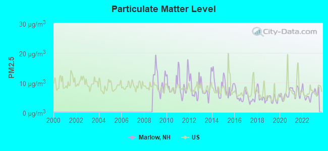
Particulate Matter (PM2.5) [µg/m3] level in 2022 was 5.57. This is significantly better than average. Closest monitor was 13.2 miles away from the city center.
| City: | 5.57 |
| U.S.: | 8.11 |
Tornado activity:
Marlow-area historical tornado activity is slightly above New Hampshire state average. It is 36% smaller than the overall U.S. average.
On 6/9/1953, a category F4 (max. wind speeds 207-260 mph) tornado 44.8 miles away from the Marlow town center killed 90 people and injured 1228 people and caused between $50,000,000 and $500,000,000 in damages.
On 8/20/1968, a category F3 (max. wind speeds 158-206 mph) tornado 29.5 miles away from the town center injured one person and caused between $5000 and $50,000 in damages.
Earthquake activity:
Marlow-area historical earthquake activity is significantly above New Hampshire state average. It is 70% smaller than the overall U.S. average.On 10/7/1983 at 10:18:46, a magnitude 5.3 (5.1 MB, 5.3 LG, 5.1 ML, Class: Moderate, Intensity: VI - VII) earthquake occurred 121.3 miles away from the city center
On 4/20/2002 at 10:50:47, a magnitude 5.3 (5.3 ML, Depth: 3.0 mi) earthquake occurred 121.6 miles away from the city center
On 4/20/2002 at 10:50:47, a magnitude 5.2 (5.2 MB, 4.2 MS, 5.2 MW, 5.0 MW) earthquake occurred 120.8 miles away from the city center
On 1/19/1982 at 00:14:42, a magnitude 4.7 (4.5 MB, 4.7 MD, 4.5 LG, Class: Light, Intensity: IV - V) earthquake occurred 40.8 miles away from the city center
On 10/16/2012 at 23:12:25, a magnitude 4.7 (4.7 ML, Depth: 10.0 mi) earthquake occurred 85.2 miles away from the city center
On 6/17/1991 at 08:53:16, a magnitude 4.1 (4.0 MB, 4.0 LG, Depth: 3.1 mi) earthquake occurred 129.3 miles away from the city center
Magnitude types: regional Lg-wave magnitude (LG), body-wave magnitude (MB), duration magnitude (MD), local magnitude (ML), surface-wave magnitude (MS), moment magnitude (MW)
Natural disasters:
The number of natural disasters in Cheshire County (27) is a lot greater than the US average (15).Major Disasters (Presidential) Declared: 16
Emergencies Declared: 11
Causes of natural disasters: Floods: 11, Storms: 11, Snows: 4, Snowstorms: 3, Winter Storms: 3, Hurricanes: 2, Blizzard: 1, Heavy Rain: 1, Ice Storm: 1, Landslide: 1, Snowfall: 1, Tropical Storm: 1, Wind: 1, Other: 1 (Note: some incidents may be assigned to more than one category).
Hospitals and medical centers near Marlow:
- MCGIRR NURSING HOME (Nursing Home, about 12 miles away; BELLOWS FALLS, VT)
- KEENE CENTER, GENESIS HEALTHCARE (Nursing Home, about 12 miles away; KEENE, NH)
- CHESHIRE MEDICAL CENTER Acute Care Hospitals (about 13 miles away; KEENE, NH)
- SNF CHESHIRE MEDICAL CTR. (Nursing Home, about 13 miles away; KEENE, NH)
- CEDARCREST INC (Hospital, about 13 miles away; KEENE, NH)
- HOSPICE OF THE MONADNOCK REGION (Hospital, about 14 miles away; KEENE, NH)
- WESTWOOD CARE AND REHABILITATION CENTER (Nursing Home, about 14 miles away; KEENE, NH)
Amtrak stations near Marlow:
Colleges/universities with over 2000 students nearest to Marlow:
- Keene State College (about 14 miles; Keene, NH; Full-time enrollment: 5,098)
- Franklin Pierce University (about 25 miles; Rindge, NH; FT enrollment: 2,139)
- NHTI-Concord's Community College (about 36 miles; Concord, NH; FT enrollment: 2,865)
- Saint Anselm College (about 37 miles; Manchester, NH; FT enrollment: 2,059)
- Mount Wachusett Community College (about 39 miles; Gardner, MA; FT enrollment: 3,143)
- Southern New Hampshire University (about 39 miles; Manchester, NH; FT enrollment: 16,552)
- Mount Washington College (about 39 miles; Manchester, NH; FT enrollment: 2,187)
Private high school in Marlow:
Public elementary/middle school in Marlow:
- JOHN PERKINS ELEMENTARY SCHOOL (Students: 50, Location: 919 NH, Grades: KG-6)
Points of interest:
Notable location: Marlow Fire Department (A). Display/hide its location on the map
Church in Marlow: Marlow United Methodist Church (A). Display/hide its location on the map
Cemetery: Baker Corner Cemetery (1). Display/hide its location on the map
Lakes and reservoirs: Big Pond (A), Cohoos Pond (B), Duck Hole (C), Gould Pond (D), Gustin Pond (E), Lower Stillwater (F), Sand Pond (G), Stone Pond (H). Display/hide their locations on the map
Streams, rivers, and creeks: Whittemore Brook (A), Lewis Brook (B), Grassy Brook (C), Gee Brook (D), Emerson Brook (E), Butler Brook (F), Abbott Brook (G). Display/hide their locations on the map
Park in Marlow: Kinson State Wildlife Management Area (1). Display/hide its location on the map
Birthplace of: Stephen Mack - Banker.
| This town: | 2.4 people |
| New Hampshire: | 2.5 people |
| This town: | 70.4% |
| Whole state: | 66.3% |
| This town: | 10.0% |
| Whole state: | 8.3% |
Likely homosexual households (counted as self-reported same-sex unmarried-partner households)
- Lesbian couples: 1.3% of all households
- Gay men: 0.6% of all households
| This town: | 4.1% |
| Whole state: | 6.5% |
| This town: | 0.1% |
| Whole state: | 2.8% |
For population 15 years and over in Marlow:
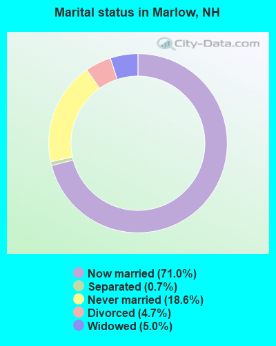
- Never married: 18.6%
- Now married: 71.0%
- Separated: 0.7%
- Widowed: 5.0%
- Divorced: 4.7%
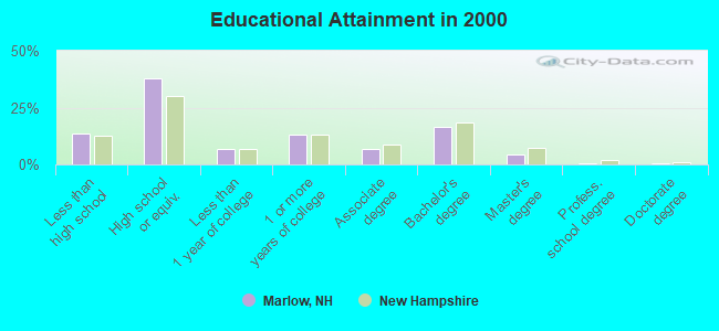
For population 25 years and over in Marlow:
- High school or higher: 86.4%
- Bachelor's degree or higher: 21.7%
- Graduate or professional degree: 5.2%
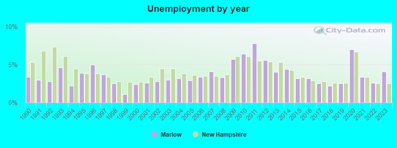
- Unemployed: 3.6%
- Mean travel time to work (commute): 31.6 minutes
| Here: | 9.7 |
| New Hampshire average: | 10.9 |
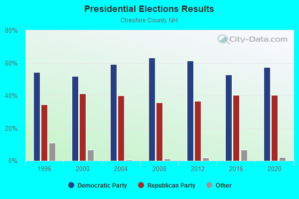
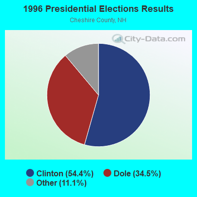
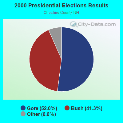
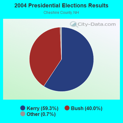

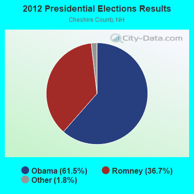
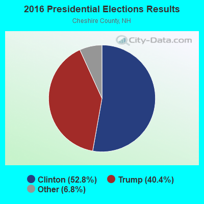
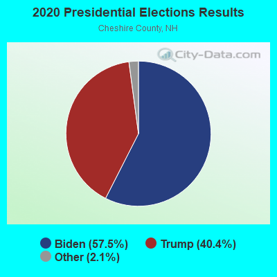
Graphs represent county-level data. Detailed 2008 Election Results
Religion statistics for Marlow, NH (based on Cheshire County data)
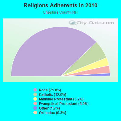
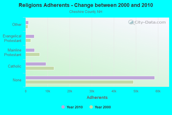
| Religion | Adherents | Congregations |
|---|---|---|
| Catholic | 9,237 | 9 |
| Mainline Protestant | 4,015 | 37 |
| Evangelical Protestant | 3,881 | 25 |
| Other | 1,292 | 13 |
| Orthodox | 250 | 1 |
| None | 58,442 | - |
Food Environment Statistics:
| This county: | 3.10 / 10,000 pop. |
| New Hampshire: | 2.14 / 10,000 pop. |
| Cheshire County: | 3.10 / 10,000 pop. |
| New Hampshire: | 1.78 / 10,000 pop. |
| Cheshire County: | 3.75 / 10,000 pop. |
| State: | 4.02 / 10,000 pop. |
| This county: | 8.67 / 10,000 pop. |
| State: | 9.70 / 10,000 pop. |
| Here: | 8.2% |
| State: | 7.6% |
| This county: | 27.5% |
| State: | 24.4% |
| Cheshire County: | 14.5% |
| State: | 15.9% |
Strongest AM radio stations in Marlow:
- WNTK (1020 AM; 10 kW; NEWPORT, NH; Owner: KOOR COMMUNICATIONS, INC.)
- WKBK (1290 AM; 5 kW; KEENE, NH; Owner: SAGA COMMUNICATIONS OF NEW ENGLAND, LLC)
- WRKO (680 AM; 50 kW; BOSTON, MA; Owner: ENTERCOM BOSTON LICENSE, LLC)
- WCRN (830 AM; 50 kW; WORCESTER, MA; Owner: CARTER BROADCASTING CORPORATION)
- WNNZ (640 AM; 50 kW; WESTFIELD, MA; Owner: CLEAR CHANNEL BROADCASTING LICENSES, INC.)
- WNBX (1480 AM; 5 kW; SPRINGFIELD, VT)
- WEEI (850 AM; 50 kW; BOSTON, MA; Owner: ENTERCOM BOSTON LICENSE, LLC)
- WVNE (760 AM; daytime; 25 kW; LEICESTER, MA; Owner: BLOUNT MASSCOM, INC.)
- WKOX (1200 AM; 50 kW; FRAMINGHAM, MA; Owner: CAPSTAR TX LIMITED PARTNERSHIP)
- WBIX (1060 AM; 40 kW; NATICK, MA; Owner: LANGER BROADCASTING CORPORATION)
- WGY (810 AM; 50 kW; SCHENECTADY, NY; Owner: CLEAR CHANNEL BROADCASTING LICENSES, INC.)
- WALE (990 AM; 50 kW; GREENVILLE, RI; Owner: NORTH AMERICAN BROADCASTING CO., INC.)
- WWZN (1510 AM; 50 kW; BOSTON, MA; Owner: ROSE CITY RADIO CORPORATION)
Strongest FM radio stations in Marlow:
- WKNE (103.7 FM; KEENE, NH; Owner: SAGA COMMUNICATIONS OF NEW ENGLAND, LLC)
- WEVN (90.7 FM; KEENE, NH; Owner: NEW HAMPSHIRE PUBLIC RADIO, INC.)
- WHDQ (106.1 FM; CLAREMONT, NH; Owner: GREAT NORTHERN RADIO, L.L.C.)
- WZSH (107.1 FM; BELLOWS FALLS, VT; Owner: GREAT NORTHERN RADIO, L.L.C.)
- WVPR (89.5 FM; WINDSOR, VT; Owner: VERMONT PUBLIC RADIO)
- WTPL (107.7 FM; HILLSBORO, NH; Owner: CONCORD BROADCASTING, L.L.C.)
- WVRR (101.7 FM; NEWPORT, NH; Owner: CAPSTAR TX LIMITED PARTNERSHIP)
- WFEX (92.1 FM; PETERBOROUGH, NH; Owner: FNX BROADCASTING OF NEW HAMPSHIRE LLC)
- WJJR (98.1 FM; RUTLAND, VT; Owner: 6 JOHNSON ROAD LICENSES, INC.)
- WZRT (97.1 FM; RUTLAND, VT; Owner: CAPSTAR TX LIMITED PARTNERSHIP)
- WEQX (102.7 FM; MANCHESTER, VT; Owner: NORTHSHIRE COMMUNICATIONS, INC.)
- W293AB (106.5 FM; KEENE, NH; Owner: GREAT NORTHERN RADIO, L.L.C.)
- WEBK (105.3 FM; KILLINGTON, VT; Owner: 6 JOHNSON ROAD LICENSES, INC.)
- WJAN (95.1 FM; SUNDERLAND, VT; Owner: 6 JOHNSON ROAD LICENSES, INC.)
- WGLV (91.7 FM; WOODSTOCK, VT; Owner: CHRISTIAN MINISTRIES INC)
- WHDQ-FM1 (106.1 FM; RUTLAND, VT; Owner: GREAT NORTHERN RADIO, L.L.C.)
- WNNH (99.1 FM; HENNIKER, NH; Owner: TELE-MEDIA COMPANY OF NEW HAMPSHIRE, L.L.C.)
- WCMK (91.9 FM; PUTNEY, VT; Owner: CHRISTIAN MINISTRIES INC)
- WVAY (100.7 FM; WILMINGTON, VT; Owner: GREAT NORTHERN RADIO, L.L.C.)
- WCFR-FM (96.3 FM; WALPOLE, NH; Owner: GREAT NORTHERN RADIO, LLC)
TV broadcast stations around Marlow:
- WEKW-TV (Channel 52; KEENE, NH; Owner: UNIVERSITY OF NEW HAMPSHIRE)
- WVTA (Channel 41; WINDSOR, VT; Owner: VERMONT ETV, INC.)
Marlow fatal accident list:
Sep 12, 1998 08:00 PM, Baine Road, Vehicles: 1, Persons: 3, Fatalities: 1, Drunk persons involved: 1
Jul 27, 1996 03:50 PM, Route 10, Vehicles: 1, Persons: 2, Fatalities: 2, Drunk persons involved: 1
Dec 3, 1995 04:30 PM, Route 123, Vehicles: 1, Persons: 1, Fatalities: 1
Sep 4, 1988 11:50 PM, 4119, Vehicles: 1, Persons: 2, Fatalities: 1
- National Bridge Inventory (NBI) Statistics
- 4Number of bridges
- 23ft / 6.8mTotal length
- $12,568,000Total costs
- 4,156Total average daily traffic
- 162Total average daily truck traffic
- 6,148Total future (year 2042) average daily traffic
FCC Registered Cell Phone Towers:
1 (See the full list of FCC Registered Cell Phone Towers in Marlow)FCC Registered Antenna Towers:
14 (See the full list of FCC Registered Antenna Towers)FCC Registered Broadcast Land Mobile Towers:
1- Fire Station (Lat: 43.127861 Lon: -72.197306), Call Sign: KDL957,
Assigned Frequencies: 154.430 MHz, Grant Date: 06/24/2022, Expiration Date: 09/15/2032, Registrant: Swnh District Fire Mutual Aid, Keene, NH 03431, Phone: (603) 352-8635, Fax: (603) 357-1985, Email:
FCC Registered Microwave Towers:
2- LEMPSTER, 6 Mi Bearing196 Deg. From Marlow (Lat: 43.205000 Lon: -72.166111), Type: Gtower, Structure height: 108.2 m, Overall height: 111.3 m, Call Sign: WMR520,
Assigned Frequencies: 6555.00 MHz, Grant Date: 01/12/2021, Expiration Date: 02/01/2031, Cancellation Date: 10/26/2022, Registrant: Holland & Knight LLP, 800 17th Street, N.W., Suite #1100, Washington, DC 20006-3906, Phone: (202) 955-3000, Fax: (202) 955-5564, Email:
- STATION, Lat: 43.083389 Lon: -72.116194, Overall height: 6.1 m, Call Sign: WNTR723,
Assigned Frequencies: 956.418 MHz, Grant Date: 05/31/2018, Expiration Date: 06/30/2028, Certifier: Ian Robertson, Registrant: Fletcher, Heald & Hildreth, P.L.C., 1300 North Seventeenth Street, 11th Floor, Arlington, VA 22209, Phone: (703) 812-0400
FCC Registered Amateur Radio Licenses:
13 (See the full list of FCC Registered Amateur Radio Licenses in Marlow)FAA Registered Aircraft:
2- Aircraft: CESSNA 150K (Category: Land, Seats: 2, Weight: Up to 12,499 Pounds, Speed: 90 mph), Engine: CONT MOTOR 0-200 SERIES (100 HP) (Reciprocating)
N-Number: 6116G, N6116G, N-6116G, Serial Number: 15071616, Year manufactured: 1969, Airworthiness Date: 12/09/1969, Certificate Issue Date: 04/29/2010
Registrant (Individual): David W Wilbur, Po Box 88, Marlow, NH 03456 - Aircraft: RANDLE DONALD G TANDEM-AIR COMMAND (Category: Land, Seats: 2, Weight: Up to 12,499 Pounds), Engine: ARROW V8F (82 HP) (Reciprocating)
N-Number: 661LL, N661LL, N-661LL, Serial Number: DGR-2, Year manufactured: 1992, Airworthiness Date: 05/29/1992, Certificate Issue Date: 08/22/1998
Registrant (Individual): David Mclanahan, Po Box 17, Marlow, NH 03456
Deregistered: Cancel Date: 07/12/2018
2005 - 2018 National Fire Incident Reporting System (NFIRS) incidents
- Fire incident types reported to NFIRS in Marlow, NH
- 8962.2%Structure Fires
- 3222.4%Outside Fires
- 128.4%Mobile Property/Vehicle Fires
- 107.0%Other
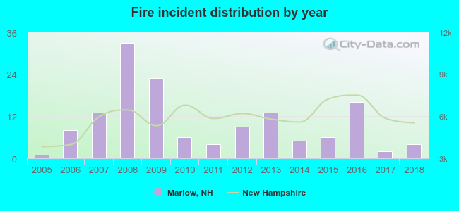 According to the data from the years 2005 - 2018 the average number of fires per year is 10. The highest number of fires - 33 took place in 2008, and the least - 1 in 2005. The data has a growing trend.
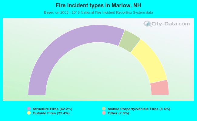 When looking into fire subcategories, the most reports belonged to: Structure Fires (62.2%), and Outside Fires (22.4%).
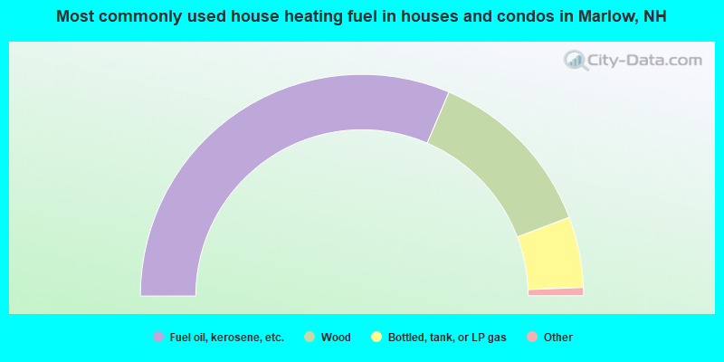
- 62.8%Fuel oil, kerosene, etc.
- 25.6%Wood
- 10.3%Bottled, tank, or LP gas
- 0.8%Electricity
- 0.4%Other fuel

- 67.5%Fuel oil, kerosene, etc.
- 17.5%Bottled, tank, or LP gas
- 15.0%Wood
Marlow compared to New Hampshire state average:
- Median house value below state average.
- Unemployed percentage significantly below state average.
- Black race population percentage significantly below state average.
- Hispanic race population percentage below state average.
- Median age above state average.
- Foreign-born population percentage significantly below state average.
- Renting percentage significantly below state average.
- Length of stay since moving in significantly above state average.
- Number of rooms per house significantly below state average.
- House age significantly below state average.

|
Total of 2 patent applications in 2008-2024.