Montville, Connecticut
Submit your own pictures of this town and show them to the world
- OSM Map
- Google Map
- MSN Map
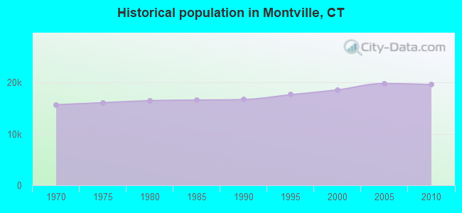
Population change since 2000: +5.5%
 |
| Males: 10,499 | |
| Females: 9,072 |
| Median resident age: | 40.7 years |
| Connecticut median age: | 39.2 years |
Zip codes: 06370.
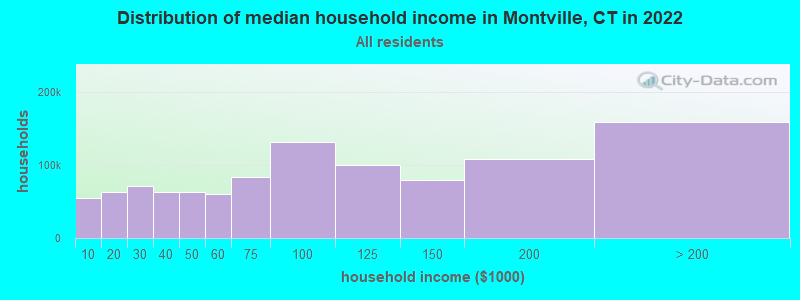
| Montville: | $90,316 |
| CT: | $88,429 |
Estimated per capita income in 2022: $40,089 (it was $22,357 in 2000)
Montville town income, earnings, and wages data
Estimated median house or condo value in 2022: $268,939 (it was $124,400 in 2000)
| Montville: | $268,939 |
| CT: | $347,200 |
Mean prices in 2022: all housing units: $336,024; detached houses: $358,368; townhouses or other attached units: $232,367; in 2-unit structures: $294,123; in 3-to-4-unit structures: $234,423; in 5-or-more-unit structures: $212,293; mobile homes: $38,564; occupied boats, rvs, vans, etc.: $86,722
Detailed information about poverty and poor residents in Montville, CT


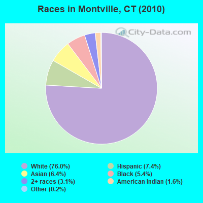
- 14,86776.0%White alone
- 1,4407.4%Hispanic
- 1,2456.4%Asian alone
- 1,0665.4%Black alone
- 6063.1%Two or more races
- 3081.6%American Indian alone
- 310.2%Other race alone
- 80.04%Native Hawaiian and Other
Pacific Islander alone
Races in Montville detailed stats: ancestries, foreign born residents, place of birth
According to our research of Connecticut and other state lists, there were 2 registered sex offenders living in Montville, Connecticut as of June 16, 2024.
The ratio of all residents to sex offenders in Montville is 9,786 to 1.
The ratio of registered sex offenders to all residents in this city is much lower than the state average.
 Recent articles from our blog. Our writers, many of them Ph.D. graduates or candidates, create easy-to-read articles on a wide variety of topics.
Ancestries: Irish (17.0%), English (14.1%), Italian (12.3%), Polish (11.4%), German (11.2%), French (10.5%).
Current Local Time: EST time zone
Incorporated on 10/12/1786
Land area: 42.0 square miles.
Population density: 466 people per square mile (low).
880 residents are foreign born (1.8% Europe, 1.7% Asia, 0.9% Latin America).
| This town: | 4.7% |
| Connecticut: | 10.9% |
| Montville town: | 1.6% ($1,992) |
| Connecticut: | 1.8% ($2,961) |
Nearest city with pop. 50,000+: Manchester, CT  (29.3 miles , pop. 54,740).
Nearest city with pop. 200,000+: Boston, MA (80.8 miles , pop. 589,141).
Nearest city with pop. 1,000,000+: Bronx, NY (99.3 miles , pop. 1,332,650).
Nearest cities:
), ), ), ), ), Latitude: 41.46 N, Longitude: 72.15 W
Area code commonly used in this area: 860
Montville tourist attractions:
Montville, Connecticut accommodation & food services, waste management - Economy and Business Data
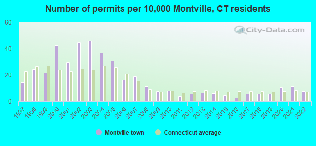
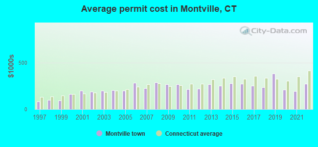
Single-family new house construction building permits:
- 2022: 14 buildings, average cost: $272,800
- 2021: 21 buildings, average cost: $197,200
- 2020: 20 buildings, average cost: $211,600
- 2019: 10 buildings, average cost: $382,000
- 2018: 10 buildings, average cost: $235,100
- 2017: 10 buildings, average cost: $253,100
- 2016: 5 buildings, average cost: $273,400
- 2015: 8 buildings, average cost: $276,600
- 2014: 11 buildings, average cost: $252,500
- 2013: 12 buildings, average cost: $266,600
- 2012: 10 buildings, average cost: $222,700
- 2011: 7 buildings, average cost: $213,900
- 2010: 15 buildings, average cost: $271,100
- 2009: 14 buildings, average cost: $267,900
- 2008: 21 buildings, average cost: $291,800
- 2007: 35 buildings, average cost: $226,000
- 2006: 30 buildings, average cost: $285,700
- 2005: 57 buildings, average cost: $198,500
- 2004: 69 buildings, average cost: $204,800
- 2003: 85 buildings, average cost: $200,100
- 2002: 83 buildings, average cost: $187,900
- 2001: 55 buildings, average cost: $199,100
- 2000: 79 buildings, average cost: $163,600
- 1999: 40 buildings, average cost: $95,600
- 1998: 45 buildings, average cost: $97,800
- 1997: 27 buildings, average cost: $83,300
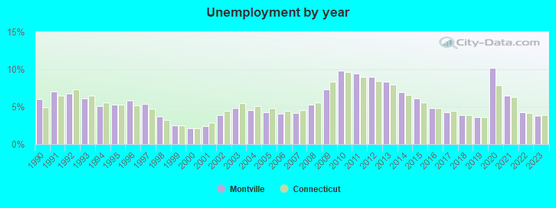
| Here: | 3.8% |
| Connecticut: | 3.9% |
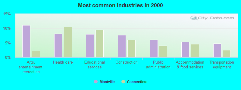
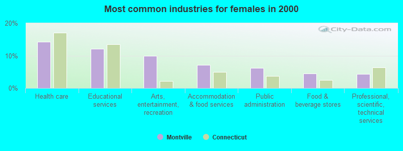
- Arts, entertainment, recreation (11.1%)
- Health care (8.2%)
- Educational services (8.0%)
- Construction (7.6%)
- Public administration (6.1%)
- Accommodation & food services (5.3%)
- Transportation equipment (4.8%)
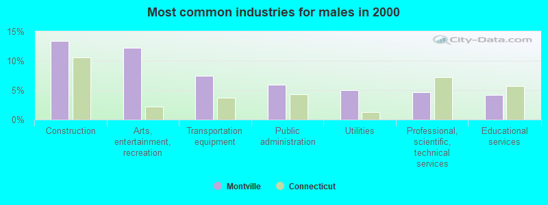
- Construction (13.3%)
- Arts, entertainment, recreation (12.3%)
- Transportation equipment (7.4%)
- Public administration (5.9%)
- Utilities (5.0%)
- Professional, scientific, technical services (4.6%)
- Educational services (4.2%)
- Health care (14.3%)
- Educational services (12.2%)
- Arts, entertainment, recreation (9.9%)
- Accommodation & food services (7.1%)
- Public administration (6.3%)
- Food & beverage stores (4.5%)
- Professional, scientific, technical services (4.4%)
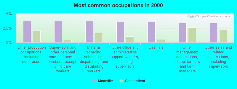
- Other production occupations, including supervisors (3.7%)
- Supervisors and other personal care and service workers, except child care workers (3.7%)
- Material recording, scheduling, dispatching, and distributing workers (3.7%)
- Other office and administrative support workers, including supervisors (3.6%)
- Cashiers (3.5%)
- Other management occupations, except farmers and farm managers (3.4%)
- Other sales and related occupations, including supervisors (3.4%)
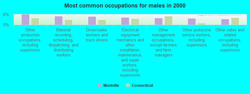
- Other production occupations, including supervisors (6.0%)
- Material recording, scheduling, dispatching, and distributing workers (5.0%)
- Driver/sales workers and truck drivers (4.9%)
- Electrical equipment mechanics and other installation, maintenance, and repair workers, including supervisors (4.4%)
- Other management occupations, except farmers and farm managers (4.1%)
- Other protective service workers, including supervisors (3.9%)
- Other sales and related occupations, including supervisors (3.5%)
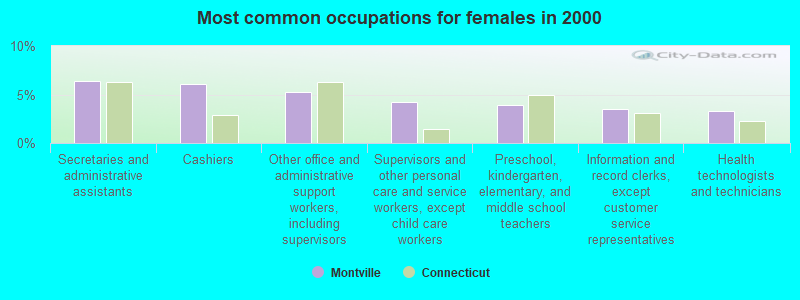
- Secretaries and administrative assistants (6.4%)
- Cashiers (6.0%)
- Other office and administrative support workers, including supervisors (5.3%)
- Supervisors and other personal care and service workers, except child care workers (4.3%)
- Preschool, kindergarten, elementary, and middle school teachers (3.9%)
- Information and record clerks, except customer service representatives (3.5%)
- Health technologists and technicians (3.3%)
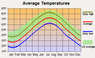
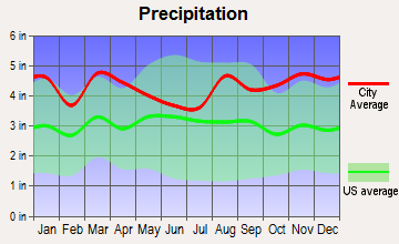
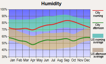
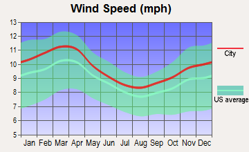
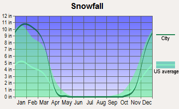
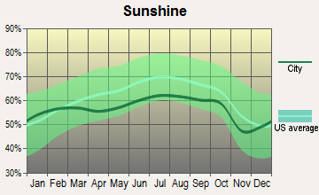
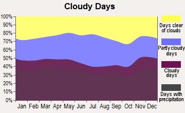
Average climate in Montville, Connecticut
Based on data reported by over 4,000 weather stations
(lower is better)
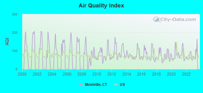
Air Quality Index (AQI) level in 2022 was 65.7. This is about average.
| City: | 65.7 |
| U.S.: | 72.6 |
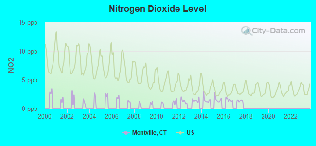
Nitrogen Dioxide (NO2) [ppb] level in 2017 was 1.35. This is significantly better than average. Closest monitor was 5.8 miles away from the city center.
| City: | 1.35 |
| U.S.: | 5.11 |
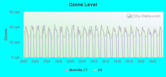
Ozone [ppb] level in 2022 was 32.9. This is about average. Closest monitor was 8.3 miles away from the city center.
| City: | 32.9 |
| U.S.: | 33.3 |
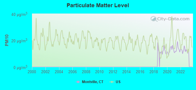
Particulate Matter (PM10) [µg/m3] level in 2022 was 12.6. This is significantly better than average. Closest monitor was 5.8 miles away from the city center.
| City: | 12.6 |
| U.S.: | 19.2 |
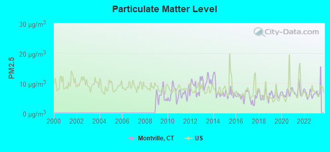
Particulate Matter (PM2.5) [µg/m3] level in 2022 was 6.31. This is better than average. Closest monitor was 5.8 miles away from the city center.
| City: | 6.31 |
| U.S.: | 8.11 |
Tornado activity:
Montville-area historical tornado activity is slightly below Connecticut state average. It is 45% smaller than the overall U.S. average.
On 7/10/1989, a category F4 (max. wind speeds 207-260 mph) tornado 39.3 miles away from the Montville town center injured 40 people and caused between $50,000,000 and $500,000,000 in damages.
On 10/3/1979, a category F4 tornado 39.5 miles away from the town center killed 3 people and injured 500 people and caused between $50,000,000 and $500,000,000 in damages.
Earthquake activity:
Montville-area historical earthquake activity is significantly above Connecticut state average. It is 72% smaller than the overall U.S. average.On 10/7/1983 at 10:18:46, a magnitude 5.3 (5.1 MB, 5.3 LG, 5.1 ML, Class: Moderate, Intensity: VI - VII) earthquake occurred 205.2 miles away from Montville center
On 4/20/2002 at 10:50:47, a magnitude 5.3 (5.3 ML, Depth: 3.0 mi) earthquake occurred 225.1 miles away from Montville center
On 4/20/2002 at 10:50:47, a magnitude 5.2 (5.2 MB, 4.2 MS, 5.2 MW, 5.0 MW) earthquake occurred 223.8 miles away from Montville center
On 1/19/1982 at 00:14:42, a magnitude 4.7 (4.5 MB, 4.7 MD, 4.5 LG, Class: Light, Intensity: IV - V) earthquake occurred 143.8 miles away from Montville center
On 10/16/2012 at 23:12:25, a magnitude 4.7 (4.7 ML, Depth: 10.0 mi) earthquake occurred 166.2 miles away from Montville center
On 8/22/1992 at 12:20:32, a magnitude 4.8 (4.8 MB, 3.8 MS, 4.7 LG, Depth: 6.2 mi) earthquake occurred 189.4 miles away from the city center
Magnitude types: regional Lg-wave magnitude (LG), body-wave magnitude (MB), duration magnitude (MD), local magnitude (ML), surface-wave magnitude (MS), moment magnitude (MW)
Natural disasters:
The number of natural disasters in New London County (22) is greater than the US average (15).Major Disasters (Presidential) Declared: 12
Emergencies Declared: 10
Causes of natural disasters: Hurricanes: 6, Snowstorms: 5, Storms: 5, Floods: 4, Blizzards: 3, Winter Storms: 3, Snows: 2, Snowfall: 1, Tropical Storm: 1, Wind: 1 (Note: some incidents may be assigned to more than one category).
Hospitals and medical centers near Montville:
- ORCHARD GROVE SPECIALTY CARE CENTER, LLC (Nursing Home, about 3 miles away; UNCASVILLE, CT)
- NORWICH DIALYSIS (Dialysis Facility, about 4 miles away; NORWICH, CT)
- UNCAS ON THAMES HOSPITAL (Hospital, about 5 miles away; NORWICH, CT)
- HOSPICE OF SOUTHEASTERN CT INC (Home Health Center, about 5 miles away; NORWICH, CT)
- GREENTREE MANOR NURSING AND REHA (Nursing Home, about 5 miles away; WATERFORD, CT)
- REGENCY HEIGHTS OF NORWICH, LLC (Nursing Home, about 6 miles away; NORWICH, CT)
- ELMACHRI REST HOME (Nursing Home, about 7 miles away; NORWICH, CT)
Amtrak stations near Montville:
- 8 miles: NEW LONDON (27 WATER ST.) . Services: ticket office, partially wheelchair accessible, enclosed waiting area, public restrooms, public payphones, paid short-term parking, paid long-term parking, call for car rental service, taxi stand, intercity bus service, public transit connection.
- 10 miles: FOXWOOD CASINO (LEDYARD, ROUTE 2) - Bus Station
- 13 miles: MYSTIC (RTE. 1) . Services: enclosed waiting area, public restrooms, public payphones, free short-term parking, call for car rental service, call for taxi service, public transit connection.
Operable nuclear power plants near Montville:
- 8 miles: Millstone 1 and 2 in Waterford, CT.
- 8 miles: Millstone 3 in Waterford, CT.
Colleges/universities with over 2000 students nearest to Montville:
- Three Rivers Community College (about 5 miles; Norwich, CT; Full-time enrollment: 2,897)
- Connecticut College (about 7 miles; New London, CT; FT enrollment: 2,068)
- Eastern Connecticut State University (about 19 miles; Willimantic, CT; FT enrollment: 4,985)
- University of Connecticut (about 25 miles; Storrs, CT; FT enrollment: 22,037)
- Wesleyan University (about 28 miles; Middletown, CT; FT enrollment: 3,517)
- Manchester Community College (about 30 miles; Manchester, CT; FT enrollment: 4,667)
- Goodwin College (about 33 miles; East Hartford, CT; FT enrollment: 3,017)
Points of interest:
Notable locations in Montville: Camp Juanita Adajuan (A), Camp Cadaho Tohaci (B), Fort Hill (C), Montville Station (D), Indian Hill Light (E), Old Indian Fort (F), Stoddard Ferry (G), Mohegan Fire Company (H), Oakdale Fire Company Station 4 (I), Montville Fire Marshal's Office (J), Chesterfield Fire Company (K), Uncasville Town Hall (L), Montville Fire Department Company Station 1 / Montville Emergency Medical Services (M), Tantaguideon Indian Museum (N), Montville Correctional Center (O), Mohegan Tribal Fire Department (P). Display/hide their locations on the map
Churches in Montville include: Mohegan Church (A), Calvary Christian Fellowship Church (B), Monhegan Congregational Church (C), Montville Center Congregational Church (D), Oakdale Baptist Church (E), Our Lady of Lakes Church (F), Saint Johns Church (G), Uncasville United Methodist Church (H), United Church of Christ (I). Display/hide their locations on the map
Cemeteries: Bogue Cemetery (1), Raymond Hill Cemetery (2), Chesterfield Cemetery (3), Rogers Cemetery (4), Saint Johns Cemetery (5), Paul Cemetery (6), Saint Patrick Cemetery (7). Display/hide their locations on the map
Lakes, reservoirs, and swamps: Powers Ice Pond (A), Davis Pond (B), Johnson Pond (C), Scholfield Pond (D), Oakdale Pond (E), Paris Pond (F), Beckwith Pond (G), Rockland Pond (H). Display/hide their locations on the map
Streams, rivers, and creeks: McAlpine Brook (A), Mohegan Brook (B), Oxoboxo Brook (C), Round Brook (D), Shantok Brook (E), Indian Creek (F), Bogue Brook (G), Whittle Brook (H), Deep Hollow Brook (I). Display/hide their locations on the map
Park in Montville: Camp Oakland (1). Display/hide its location on the map
Birthplace of: James Hillhouse - Politician, Ned Hanlon (baseball) - Baseball player, Oliver H. Prince - Politician.
| This town: | 2.6 people |
| Connecticut: | 2.5 people |
| This town: | 70.2% |
| Whole state: | 66.3% |
| This town: | 8.0% |
| Whole state: | 6.6% |
Likely homosexual households (counted as self-reported same-sex unmarried-partner households)
- Lesbian couples: 0.4% of all households
- Gay men: 0.2% of all households
| This town: | 4.1% |
| Whole state: | 7.9% |
| This town: | 2.5% |
| Whole state: | 3.9% |
People in group quarters in Montville in 2010:
- 1,495 people in state prisons
- 136 people in nursing facilities/skilled-nursing facilities
- 25 people in group homes intended for adults
- 16 people in correctional residential facilities
- 5 people in residential treatment centers for adults
- 4 people in residential treatment centers for juveniles (non-correctional)
People in group quarters in Montville in 2000:
- 1,466 people in state prisons
- 123 people in nursing homes
- 19 people in other noninstitutional group quarters
- 16 people in homes or halfway houses for drug/alcohol abuse
- 15 people in homes for the mentally ill
- 6 people in religious group quarters
- 2 people in homes for the mentally retarded
Banks with branches in Montville (2011 data):
- RBS Citizens, National Association: Montville Branch at 221 Norwich-New London Turnpike, branch established on 1974/07/08. Info updated 2007/09/19: Bank assets: $106,940.6 mil, Deposits: $75,690.2 mil, headquarters in Providence, RI, positive income, 1135 total offices, Holding Company: Uk Financial Investments Limited
For population 15 years and over in Montville:
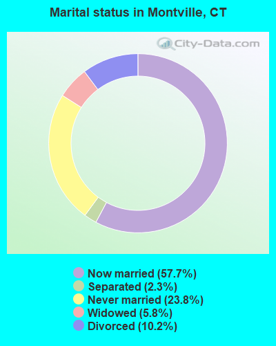
- Never married: 23.8%
- Now married: 57.7%
- Separated: 2.3%
- Widowed: 5.8%
- Divorced: 10.2%
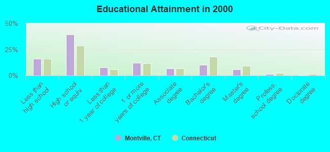
For population 25 years and over in Montville:
- High school or higher: 83.9%
- Bachelor's degree or higher: 17.6%
- Graduate or professional degree: 7.5%
- Unemployed: 3.3%
- Mean travel time to work (commute): 23.5 minutes
| Here: | 10.2 |
| Connecticut average: | 12.8 |
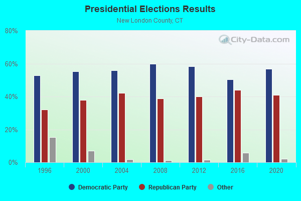
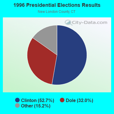
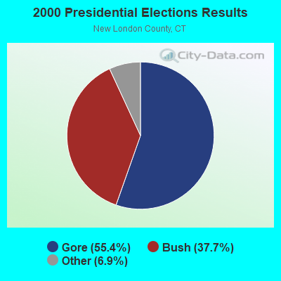

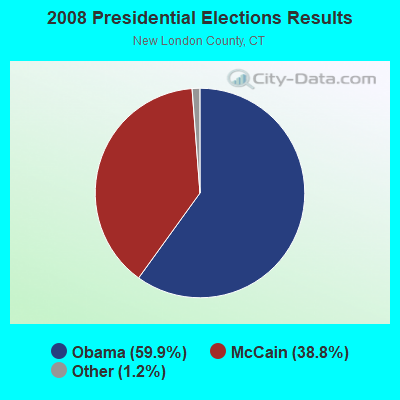

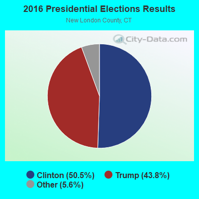
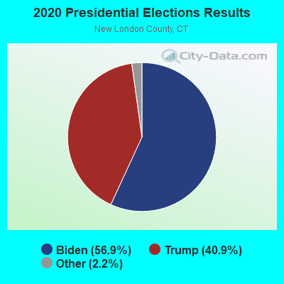
Graphs represent county-level data. Detailed 2008 Election Results
Religion statistics for Montville, CT (based on New London County data)
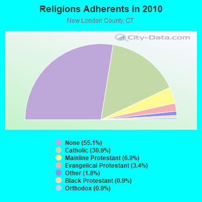
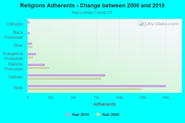
| Religion | Adherents | Congregations |
|---|---|---|
| Catholic | 84,765 | 34 |
| Mainline Protestant | 18,993 | 79 |
| Evangelical Protestant | 9,320 | 75 |
| Other | 5,022 | 32 |
| Black Protestant | 2,594 | 10 |
| Orthodox | 2,456 | 4 |
| None | 150,905 | - |
Food Environment Statistics:
| This county: | 1.82 / 10,000 pop. |
| Connecticut: | 2.21 / 10,000 pop. |
| New London County: | 0.11 / 10,000 pop. |
| State: | 0.07 / 10,000 pop. |
| This county: | 1.36 / 10,000 pop. |
| Connecticut: | 1.02 / 10,000 pop. |
| Here: | 3.22 / 10,000 pop. |
| Connecticut: | 2.27 / 10,000 pop. |
| New London County: | 10.01 / 10,000 pop. |
| Connecticut: | 9.19 / 10,000 pop. |
| New London County: | 7.6% |
| State: | 7.3% |
| New London County: | 22.4% |
| State: | 21.5% |
| Here: | 16.5% |
| Connecticut: | 15.8% |
6.16% of this county's 2021 resident taxpayers lived in other counties in 2020 ($81,025 average adjusted gross income)
| Here: | 6.16% |
| Connecticut average: | 5.79% |
0.04% of residents moved from foreign countries ($359 average AGI)
New London County: 0.04% Connecticut average: 0.02%
Top counties from which taxpayers relocated into this county between 2020 and 2021:
| from Hartford County, CT | |
| from Windham County, CT | |
| from Middlesex County, CT |
6.02% of this county's 2020 resident taxpayers moved to other counties in 2021 ($71,482 average adjusted gross income)
| Here: | 6.02% |
| Connecticut average: | 5.82% |
0.05% of residents moved to foreign countries ($502 average AGI)
New London County: 0.05% Connecticut average: 0.02%
Top counties to which taxpayers relocated from this county between 2020 and 2021:
| to Hartford County, CT | |
| to Windham County, CT | |
| to Middlesex County, CT |
| Businesses in Montville, CT | ||||
| Name | Count | Name | Count | |
|---|---|---|---|---|
| Dunkin Donuts | 2 | Starbucks | 1 | |
| GNC | 1 | Stop & Shop | 1 | |
| McDonald's | 1 | |||
Strongest AM radio stations in Montville:
- WICH (1310 AM; 5 kW; NORWICH, CT; Owner: WICH, INCORPORATED)
- WTIC (1080 AM; 50 kW; HARTFORD, CT; Owner: INFINITY RADIO OPERATIONS INC.)
- WALE (990 AM; 50 kW; GREENVILLE, RI; Owner: NORTH AMERICAN BROADCASTING CO., INC.)
- WSUB (980 AM; 1 kW; GROTON, CT; Owner: CITADEL BROADCASTING COMPANY)
- WNNZ (640 AM; 50 kW; WESTFIELD, MA; Owner: CLEAR CHANNEL BROADCASTING LICENSES, INC.)
- WCRN (830 AM; 50 kW; WORCESTER, MA; Owner: CARTER BROADCASTING CORPORATION)
- WLIS (1420 AM; 5 kW; OLD SAYBROOK, CT; Owner: CROSSROADS COMM. OLD SAYBROOK, LLC)
- WEEI (850 AM; 50 kW; BOSTON, MA; Owner: ENTERCOM BOSTON LICENSE, LLC)
- WVNE (760 AM; daytime; 25 kW; LEICESTER, MA; Owner: BLOUNT MASSCOM, INC.)
- WRKO (680 AM; 50 kW; BOSTON, MA; Owner: ENTERCOM BOSTON LICENSE, LLC)
- WKOX (1200 AM; 50 kW; FRAMINGHAM, MA; Owner: CAPSTAR TX LIMITED PARTNERSHIP)
- WBIX (1060 AM; 40 kW; NATICK, MA; Owner: LANGER BROADCASTING CORPORATION)
- WFAN (660 AM; 50 kW; NEW YORK, NY; Owner: INFINITY BROADCASTING OPERATIONS, INC.)
Strongest FM radio stations in Montville:
- WKNL (100.9 FM; NEW LONDON, CT; Owner: HALL COMMUNICATIONS, INC.)
- WCTY (97.7 FM; NORWICH, CT; Owner: WICH, INC.)
- WBMW (106.5 FM; LEDYARD, CT; Owner: RED WOLF BROADCASTING CORPORATION)
- WQGN-FM (105.5 FM; GROTON, CT; Owner: CITADEL BROADCASTING COMPANY)
- WHJM (107.7 FM; PAWCATUCK, CT; Owner: FULLER BROADCASTING INTERNATIONAL, LLC)
- WCNI (90.9 FM; NEW LONDON, CT; Owner: CONNECTICUT COLLEGE BROADCASTING ASSOCIATION, INC.)
- WNLC (98.7 FM; EAST LYME, CT; Owner: HALL COMMUNICATIONS, INC.)
- WILI-FM (98.3 FM; WILLIMANTIC, CT; Owner: NUTMEG BROADCASTING COMPANY)
- W233AG (94.5 FM; NEW LONDON, CT; Owner: MONROE BOARD OF EDUCATION)
- WECS (90.1 FM; WILLIMANTIC, CT; Owner: EASTERN CONNECTICUT STATE COLLEGE)
- WRCH (100.5 FM; NEW BRITAIN, CT; Owner: INFINITY RADIO OPERATIONS INC.)
- WWRX-FM (103.7 FM; WESTERLY, RI; Owner: FNX BROADCASTING OF RHODE ISLAND, LLC)
- WXLM (102.3 FM; STONINGTON, CT; Owner: CITADEL BROADCASTING COMPANY)
- WKCI-FM (101.3 FM; HAMDEN, CT; Owner: CLEAR CHANNEL BROADCASTING LICENSES, INC.)
- WKSS (95.7 FM; HARTFORD-MERIDEN, CT; Owner: CAPSTAR TX LIMITED PARTNERSHIP)
- WWYZ (92.5 FM; WATERBURY, CT; Owner: CAPSTAR TX LIMITED PARTNERSHIP)
- WZMX (93.7 FM; HARTFORD, CT; Owner: INFINITY RADIO OPERATIONS INC.)
- WHCN (105.9 FM; HARTFORD, CT; Owner: CAPSTAR TX LIMITED PARTNERSHIP)
- WMRQ (104.1 FM; WATERBURY, CT; Owner: CAPSTAR TX LIMITED PARTNERSHIP)
- WHUS (91.7 FM; STORRS, CT; Owner: THE BD. OF TRUSTEES, THE UNIV. OF CT)
TV broadcast stations around Montville:
- WHPX (Channel 26; NEW LONDON, CT; Owner: PAXSON HARTFORD LICENSE, INC.)
- WEDN (Channel 53; NORWICH, CT; Owner: CONNECTICUT PUBLIC BROADCASTING, INC.)
- WPXQ (Channel 69; BLOCK ISLAND, RI; Owner: OCEAN STATE TELEVISION, L.L.C.)
- WTIC-TV (Channel 61; HARTFORD, CT; Owner: TRIBUNE TELEVISION COMPANY)
- W11BJ (Channel 11; HARTFORD, CT; Owner: COMMUNICATIONS SITE MANAGEMENT LLC)
- WTXX (Channel 20; WATERBURY, CT; Owner: WTXX INC.)
- WVIT (Channel 30; NEW BRITAIN, CT; Owner: OUTLET BROADCASTING, INC)
- WUVN (Channel 18; HARTFORD, CT; Owner: ENTRAVISION HOLDINGS, LLC)
- WEDH (Channel 24; HARTFORD, CT; Owner: CONNECTICUT PUBLIC BROADCASTING, INC.)
- WYDN (Channel 48; WORCESTER, MA; Owner: EDUCATIONAL PUBLIC TV CORPORATION)
- WTNH (Channel 8; NEW HAVEN, CT; Owner: WTNH BROADCASTING, INC.)
Medal of Honor Recipients
Medal of Honor Recipient born in Montville: John G. Palmer.
- National Bridge Inventory (NBI) Statistics
- 35Number of bridges
- 394ft / 120mTotal length
- 843,215Total average daily traffic
- 84,476Total average daily truck traffic
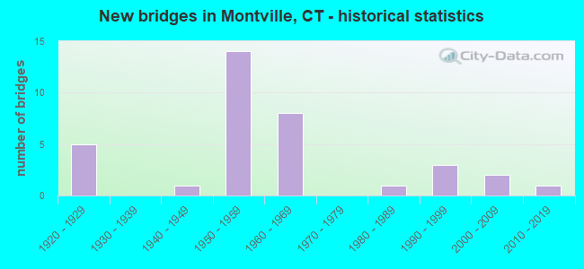
- New bridges - historical statistics
- 51920-1929
- 11940-1949
- 141950-1959
- 81960-1969
- 11980-1989
- 31990-1999
- 22000-2009
- 12010-2019
FCC Registered Antenna Towers:
48 (See the full list of FCC Registered Antenna Towers in Montville)FCC Registered Commercial Land Mobile Towers:
1 (See the full list of FCC Registered Commercial Land Mobile Towers in Montville, CT)FCC Registered Private Land Mobile Towers:
2 (See the full list of FCC Registered Private Land Mobile Towers)FCC Registered Broadcast Land Mobile Towers:
19 (See the full list of FCC Registered Broadcast Land Mobile Towers)FCC Registered Microwave Towers:
8 (See the full list of FCC Registered Microwave Towers in this town)FCC Registered Paging Towers:
13 (See the full list of FCC Registered Paging Towers)FCC Registered Amateur Radio Licenses:
1- Call Sign: KC1GQZ, Licensee ID: L02065774, Grant Date: 11/23/2016, Expiration Date: 11/23/2026, Certifier: Daniel J Almeida, Registrant: Daniel J Almeida, Montville, CT 06353
2004 - 2018 National Fire Incident Reporting System (NFIRS) incidents
- Fire incident types reported to NFIRS in Montville, CT
- 31147.0%Structure Fires
- 18928.6%Outside Fires
- 12218.5%Mobile Property/Vehicle Fires
- 395.9%Other
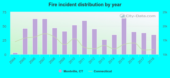 Based on the data from the years 2004 - 2018 the average number of fire incidents per year is 44. The highest number of reported fires - 64 took place in 2015, and the least - 3 in 2004. The data has a growing trend.
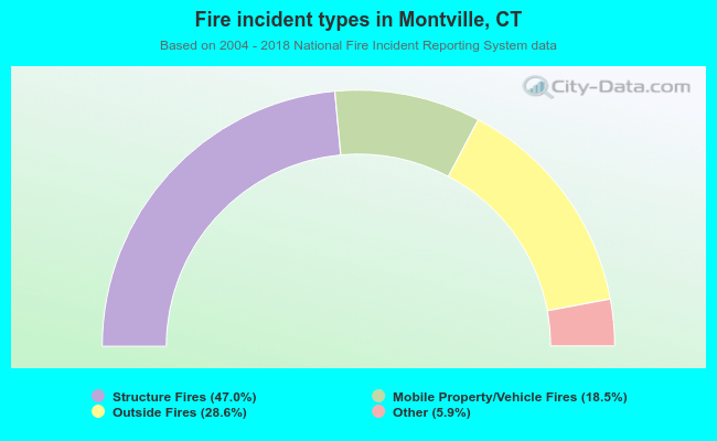 When looking into fire subcategories, the most reports belonged to: Structure Fires (47.0%), and Outside Fires (28.6%).
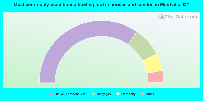
- 69.1%Fuel oil, kerosene, etc.
- 15.4%Utility gas
- 9.2%Electricity
- 3.3%Wood
- 2.7%Bottled, tank, or LP gas
- 0.1%Coal or coke
- 0.1%Other fuel
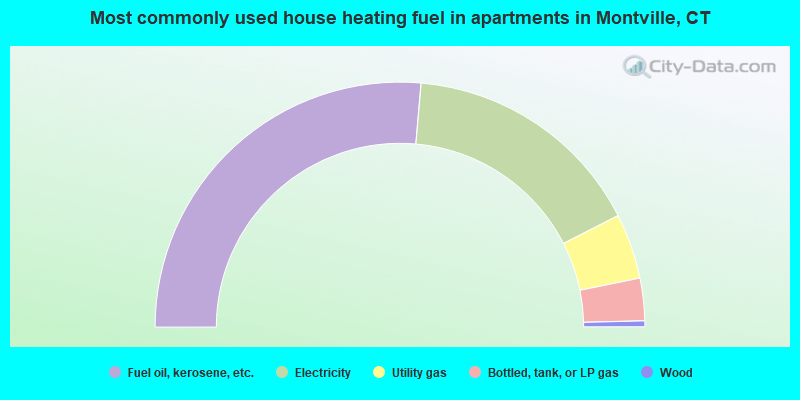
- 52.7%Fuel oil, kerosene, etc.
- 32.2%Electricity
- 8.6%Utility gas
- 5.6%Bottled, tank, or LP gas
- 0.8%Wood
Montville compared to Connecticut state average:
- Unemployed percentage significantly below state average.
- Hispanic race population percentage below state average.
- Foreign-born population percentage significantly below state average.
- Renting percentage below state average.
- Length of stay since moving in significantly above state average.
- Number of rooms per house significantly below state average.
- House age significantly below state average.
- Institutionalized population percentage significantly above state average.
- Percentage of population with a bachelor's degree or higher below state average.
Montville on our top lists:
- #21 on the list of "Top 101 cities with largest percentage of males in occupations: supervisors and other personal care and service workers except personal appearance, transportation, and child care workers (population 5,000+)"
- #25 on the list of "Top 101 cities with largest percentage of females in industries: water transportation (population 5,000+)"
- #29 on the list of "Top 101 cities with largest percentage of males in occupations: other protective service workers including supervisors (population 5,000+)"
- #30 on the list of "Top 101 cities with largest percentage of females in occupations: supervisors and other personal care and service workers except personal appearance, transportation, and child care workers (population 5,000+)"
- #33 on the list of "Top 101 cities with largest percentage of females in industries: petroleum and petroleum products merchant wholesalers (population 5,000+)"
- #44 on the list of "Top 101 cities with largest percentage of females in occupations: rail and water transportation workers (population 5,000+)"
- #48 on the list of "Top 101 cities with largest percentage of males in occupations: other transportation workers (population 5,000+)"
- #55 on the list of "Top 101 cities with largest percentage of females in occupations: other construction workers and helpers (population 5,000+)"
- #55 on the list of "Top 101 cities with largest percentage of males in industries: arts, entertainment, and recreation (population 5,000+)"
- #74 on the list of "Top 101 cities with largest percentage of females in industries: music stores (population 5,000+)"
- #87 on the list of "Top 101 cities with largest percentage of females in industries: arts, entertainment, and recreation (population 5,000+)"
- #88 on the list of "Top 101 cities with largest percentage of males in industries: alcoholic beverages merchant wholesalers (population 5,000+)"
- #88 on the list of "Top 101 cities with largest percentage of males in industries: transportation equipment (population 5,000+)"
- #89 on the list of "Top 101 cities with largest percentage of females in industries: chemicals (population 5,000+)"
- #16 on the list of "Top 101 counties with the lowest average weight of females"
- #28 on the list of "Top 101 counties with the highest percentage of residents that visited a dentist within the past year"
- #28 on the list of "Top 101 counties with highest percentage of residents voting for Obama (Democrat) in the 2012 Presidential Election"
- #51 on the list of "Top 101 counties with the lowest percentage of residents that drank alcohol in the past 30 days"
- #66 on the list of "Top 101 counties with the lowest percentage of residents that keep firearms around their homes"