Rosewood, Kentucky
Submit your own pictures of this place and show them to the world
- OSM Map
- General Map
- Google Map
- MSN Map

| Males: 746 | |
| Females: 743 |
| Median resident age: | 39.8 years |
| Kentucky median age: | 35.9 years |
Zip code: 42345
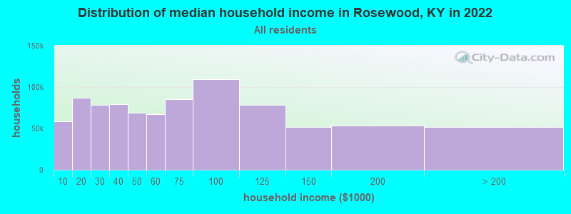
| Rosewood: | $56,451 |
| KY: | $59,341 |
Estimated per capita income in 2022: $37,138 (it was $17,142 in 2000)
Rosewood CCD income, earnings, and wages data
Estimated median house or condo value in 2022: $130,780 (it was $52,500 in 2000)
| Rosewood: | $130,780 |
| KY: | $196,300 |
Detailed information about poverty and poor residents in Rosewood, KY


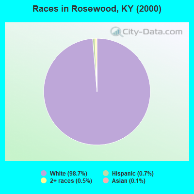
- 1,48698.7%White alone
- 110.7%Hispanic
- 70.5%Two or more races
- 20.1%Asian alone
Races in Rosewood detailed stats: ancestries, foreign born residents, place of birth
 Recent articles from our blog. Our writers, many of them Ph.D. graduates or candidates, create easy-to-read articles on a wide variety of topics.
Current Local Time: CST time zone
Elevation: 602 feet
Land area: 78.3 square miles.
Population density: 19 people per square mile (very low).

| Rosewood CCD: | 0.8% ($397) |
| Kentucky: | 0.8% ($610) |
Nearest city with pop. 50,000+: Clarksville, TN  (39.2 miles , pop. 103,455).
Nearest city with pop. 200,000+: Metropolitan Government, TN (68.4 miles , pop. 569,891).
Nearest city with pop. 1,000,000+: Chicago, IL (329.3 miles , pop. 2,896,016).
Nearest cities:
), ), ), ), ), ), Latitude: 37.10 N, Longitude: 87.14 W
Area code commonly used in this area: 270

| Here: | 5.7% |
| Kentucky: | 3.8% |
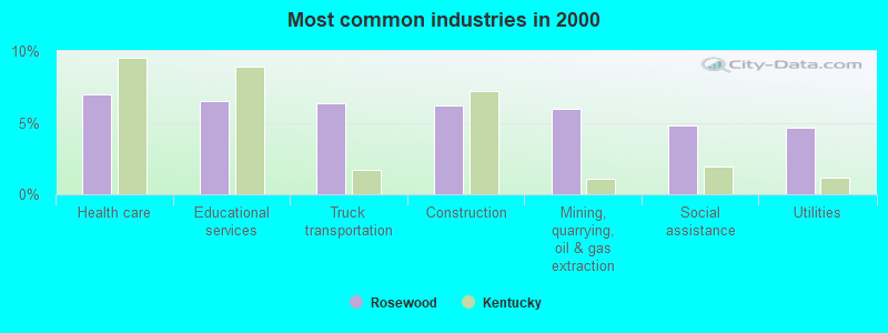
- Health care (7.0%)
- Educational services (6.5%)
- Truck transportation (6.3%)
- Construction (6.2%)
- Mining, quarrying, oil & gas extraction (6.0%)
- Social assistance (4.8%)
- Utilities (4.7%)
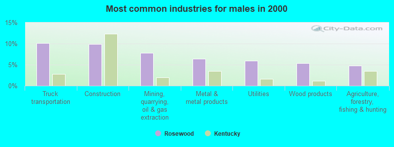
- Truck transportation (10.2%)
- Construction (9.9%)
- Mining, quarrying, oil & gas extraction (7.8%)
- Metal & metal products (6.4%)
- Utilities (5.9%)
- Wood products (5.3%)
- Agriculture, forestry, fishing & hunting (4.8%)
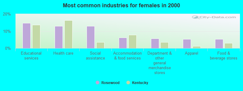
- Educational services (14.6%)
- Health care (12.8%)
- Social assistance (12.8%)
- Accommodation & food services (6.2%)
- Department & other general merchandise stores (5.8%)
- Apparel (5.3%)
- Food & beverage stores (5.3%)
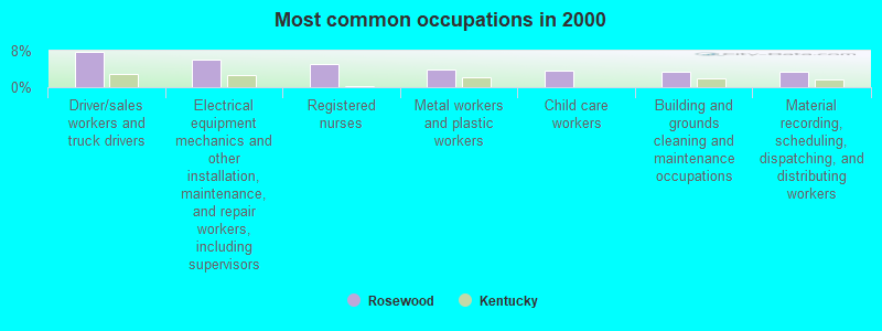
- Driver/sales workers and truck drivers (7.7%)
- Electrical equipment mechanics and other installation, maintenance, and repair workers, including supervisors (6.2%)
- Registered nurses (5.2%)
- Metal workers and plastic workers (4.0%)
- Child care workers (3.7%)
- Building and grounds cleaning and maintenance occupations (3.5%)
- Material recording, scheduling, dispatching, and distributing workers (3.3%)

- Driver/sales workers and truck drivers (12.3%)
- Electrical equipment mechanics and other installation, maintenance, and repair workers, including supervisors (9.9%)
- Construction traders workers except carpenters, electricians, painters, plumbers, and construction laborers (5.3%)
- Assemblers and fabricators (5.3%)
- Extraction workers (5.1%)
- Metal workers and plastic workers (4.8%)
- Sales representatives, services, wholesale and manufacturing (3.7%)

- Child care workers (9.7%)
- Registered nurses (8.0%)
- Other office and administrative support workers, including supervisors (7.5%)
- Preschool, kindergarten, elementary, and middle school teachers (5.8%)
- Textile, apparel, and furnishings workers (5.3%)
- Building and grounds cleaning and maintenance occupations (4.9%)
- Cashiers (4.9%)
Average climate in Rosewood, Kentucky
Based on data reported by over 4,000 weather stations


(lower is better)
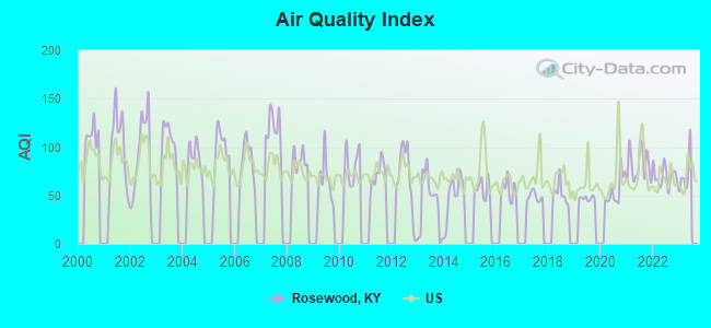
Air Quality Index (AQI) level in 2022 was 69.7. This is about average.
| City: | 69.7 |
| U.S.: | 72.6 |
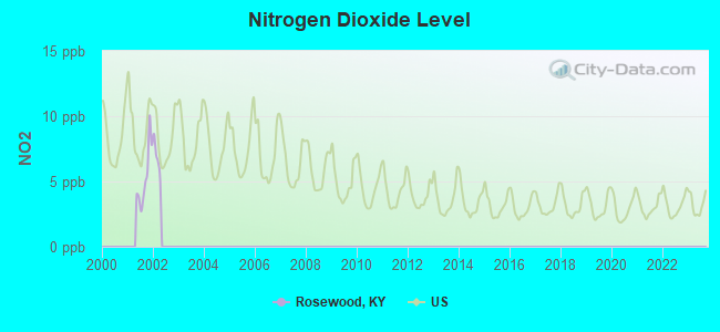
Nitrogen Dioxide (NO2) [ppb] level in 2001 was 5.36. This is about average. Closest monitor was 8.9 miles away from the city center.
| City: | 5.36 |
| U.S.: | 5.11 |
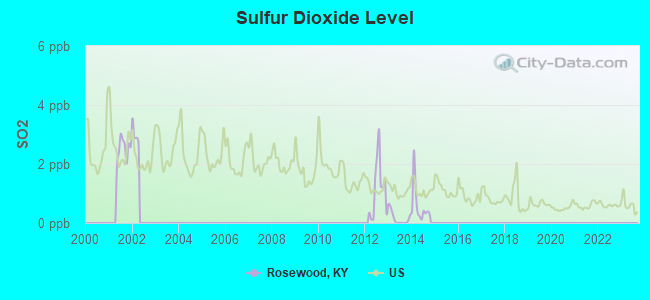
Sulfur Dioxide (SO2) [ppb] level in 2014 was 0.598. This is significantly better than average. Closest monitor was 7.4 miles away from the city center.
| City: | 0.598 |
| U.S.: | 1.515 |
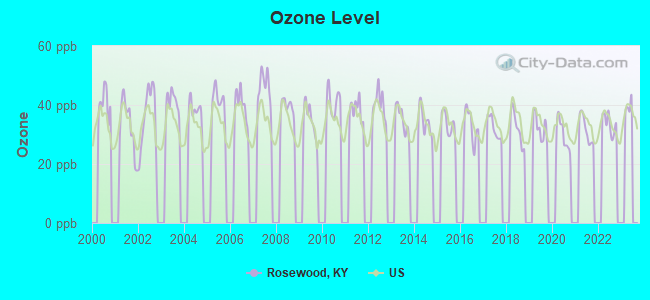
Ozone [ppb] level in 2022 was 33.7. This is about average. Closest monitor was 8.9 miles away from the city center.
| City: | 33.7 |
| U.S.: | 33.3 |
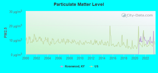
Particulate Matter (PM2.5) [µg/m3] level in 2022 was 9.31. This is about average. Closest monitor was 16.3 miles away from the city center.
| City: | 9.31 |
| U.S.: | 8.11 |
Tornado activity:
Rosewood-area historical tornado activity is slightly above Kentucky state average. It is 54% greater than the overall U.S. average.
On 11/15/2005, a category F4 (max. wind speeds 207-260 mph) tornado 23.8 miles away from the Rosewood place center injured 40 people and caused $31 million in damages.
On 4/3/1968, a category F4 tornado 26.9 miles away from the place center killed 2 people and injured 30 people and caused between $500,000 and $5,000,000 in damages.
Earthquake activity:
Rosewood-area historical earthquake activity is significantly above Kentucky state average. It is 210% greater than the overall U.S. average.On 4/18/2008 at 09:36:59, a magnitude 5.4 (5.1 MB, 4.8 MS, 5.4 MW, 5.2 MW, Class: Moderate, Intensity: VI - VII) earthquake occurred 102.1 miles away from Rosewood center
On 4/18/2008 at 09:36:59, a magnitude 5.2 (5.2 MW, Depth: 8.9 mi) earthquake occurred 102.0 miles away from the city center
On 6/18/2002 at 17:37:15, a magnitude 5.0 (4.3 MB, 4.6 MW, 5.0 LG) earthquake occurred 70.7 miles away from Rosewood center
On 6/10/1987 at 23:48:54, a magnitude 5.1 (4.9 MB, 4.4 MS, 4.6 MS, 5.1 LG) earthquake occurred 125.8 miles away from Rosewood center
On 9/26/1990 at 13:18:51, a magnitude 5.0 (4.7 MB, 4.8 LG, 5.0 LG, Depth: 7.7 mi) earthquake occurred 132.0 miles away from the city center
On 4/18/2008 at 15:14:16, a magnitude 4.8 (4.5 MB, 4.8 MW, 4.6 MW, Class: Light, Intensity: IV - V) earthquake occurred 102.8 miles away from the city center
Magnitude types: regional Lg-wave magnitude (LG), body-wave magnitude (MB), surface-wave magnitude (MS), moment magnitude (MW)
Natural disasters:
The number of natural disasters in Muhlenberg County (14) is near the US average (15).Major Disasters (Presidential) Declared: 11
Emergencies Declared: 2
Causes of natural disasters: Storms: 7, Floods: 6, Tornadoes: 3, Winter Storms: 3, Snows: 2, Winds: 2, Blizzard: 1, Freeze: 1, Hurricane: 1, Mudslide: 1, Tropical Depression: 1, Other: 1 (Note: some incidents may be assigned to more than one category).
Hospitals and medical centers near Rosewood:
- MUHLENBERG COMMUNITY HOSP HHA (Home Health Center, about 8 miles away; GREENVILLE, KY)
- MUHLENBERG COMMUNITY HOSPITAL Acute Care Hospitals (about 8 miles away; GREENVILLE, KY)
- KINDRED NURSING AND REHABILITATION-MAPLE (Nursing Home, about 9 miles away; GREENVILLE, KY)
- BELLE MEADE HOME (Nursing Home, about 9 miles away; GREENVILLE, KY)
- BELLE MEADE HOME ICF (Nursing Home, about 9 miles away; GREENVILLE, KY)
Colleges/universities with over 2000 students nearest to Rosewood:
- Hopkinsville Community College (about 25 miles; Hopkinsville, KY; Full-time enrollment: 2,269)
- Madisonville Community College (about 28 miles; Madisonville, KY; FT enrollment: 2,082)
- Southcentral Kentucky Community and Technical College (about 38 miles; Bowling Green, KY; FT enrollment: 2,794)
- Western Kentucky University (about 39 miles; Bowling Green, KY; FT enrollment: 16,942)
- Austin Peay State University (about 41 miles; Clarksville, TN; FT enrollment: 8,621)
- Owensboro Community and Technical College (about 43 miles; Owensboro, KY; FT enrollment: 2,754)
- Volunteer State Community College (about 63 miles; Gallatin, TN; FT enrollment: 5,311)
Points of interest:
Churches in Rosewood include: Greenbrier Church (A), Joines Church (B), Landmark Assembly Church (C), Lone Star Church (D), Olive Grove Church (E), Cherry Grove Church (F). Display/hide their locations on the map
Cemeteries: Heltsley Cemetery (1), Cornett Cemetery (2), Craig Cemetery (3), Allen Cemetery (4), Elkins Cemetery (5), Shutt Cemetery (6). Display/hide their locations on the map
Reservoir: Kirkwood Lake (A). Display/hide its location on the map
Streams, rivers, and creeks: Boggess Creek (A), Carters Creek (B), Slaughter Branch (C), Buck Fork Pond River (D), Buck Creek (E), Saltlick Creek (F), Sandlick Creek (G). Display/hide their locations on the map
Birthplace of: Merle Travis - (1917-1983), country music singer.
| This place: | 2.7 people |
| Kentucky: | 2.5 people |
| This place: | 75.9% |
| Whole state: | 66.9% |
| This place: | 5.7% |
| Whole state: | 6.4% |
Likely homosexual households (counted as self-reported same-sex unmarried-partner households)
- Lesbian couples: 0.2% of all households
- Gay men: 0.0% of all households
| This place: | 13.8% |
| Whole state: | 15.8% |
| This place: | 7.6% |
| Whole state: | 6.6% |
For population 15 years and over in Rosewood:
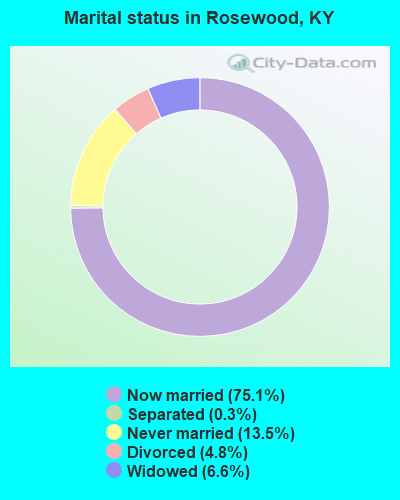
- Never married: 13.5%
- Now married: 75.1%
- Separated: 0.3%
- Widowed: 6.6%
- Divorced: 4.8%
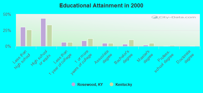
For population 25 years and over in Rosewood:
- High school or higher: 69.9%
- Bachelor's degree or higher: 6.1%
- Graduate or professional degree: 2.5%
- Unemployed: 6.0%
- Mean travel time to work (commute): 31.1 minutes
| Here: | 13.7 |
| Kentucky average: | 13.8 |
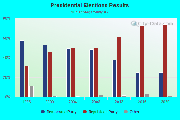
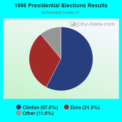
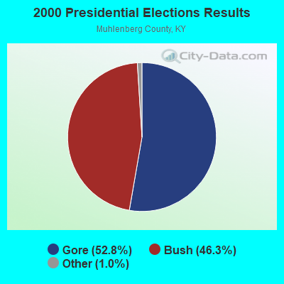
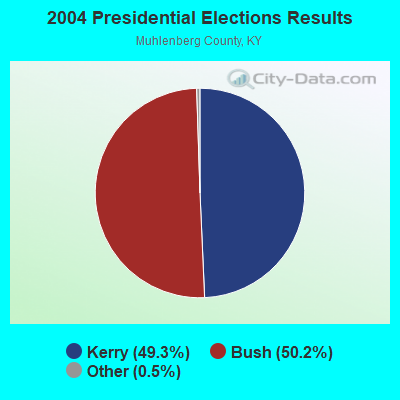
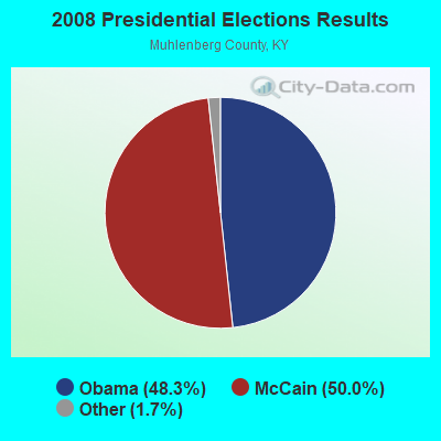
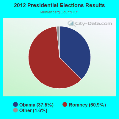

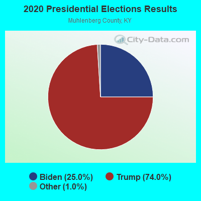
Graphs represent county-level data. Detailed 2008 Election Results
Religion statistics for Rosewood, KY (based on Muhlenberg County data)
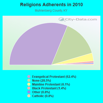
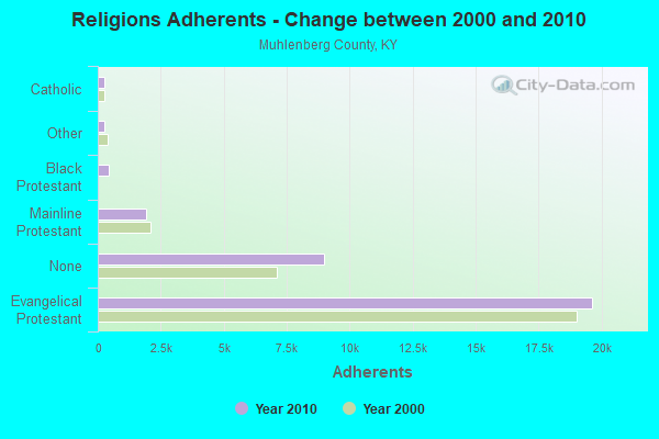
| Religion | Adherents | Congregations |
|---|---|---|
| Evangelical Protestant | 19,645 | 72 |
| Mainline Protestant | 1,922 | 19 |
| Black Protestant | 451 | 3 |
| Other | 246 | 2 |
| Catholic | 245 | 1 |
| None | 8,990 | - |
Food Environment Statistics:
| Here: | 2.55 / 10,000 pop. |
| State: | 2.19 / 10,000 pop. |
| Muhlenberg County: | 0.32 / 10,000 pop. |
| Kentucky: | 0.25 / 10,000 pop. |
| This county: | 0.64 / 10,000 pop. |
| State: | 0.74 / 10,000 pop. |
| This county: | 3.83 / 10,000 pop. |
| Kentucky: | 4.36 / 10,000 pop. |
| Here: | 6.07 / 10,000 pop. |
| Kentucky: | 5.74 / 10,000 pop. |
| Muhlenberg County: | 11.4% |
| Kentucky: | 11.0% |
| Muhlenberg County: | 30.2% |
| Kentucky: | 30.0% |
| Here: | 15.2% |
| Kentucky: | 15.9% |
Strongest AM radio stations in Rosewood:
- WSM (650 AM; 50 kW; NASHVILLE, TN; Owner: GAYLORD ENTERTAINMENT COMPANY)
- WKDA (1200 AM; 50 kW; NASHVILLE, TN; Owner: RADIO NASHVILLE, INC.)
- WNQM (1300 AM; 50 kW; NASHVILLE, TN; Owner: WNQM. INC.)
- WAMB (1160 AM; 50 kW; DONELSON, TN; Owner: GREAT SOUTHERN BROADCASTING COMPANY, INC.)
- WLAC (1510 AM; 50 kW; NASHVILLE, TN; Owner: CAPSTAR TX LIMITED PARTNERSHIP)
- WNES (1050 AM; 1 kW; CENTRAL CITY, KY; Owner: STARLIGHT BROADCASTING CO., INC.)
- WRUS (610 AM; 2 kW; RUSSELLVILLE, KY; Owner: LOGAN RADIO INCORPORATED)
- WHAS (840 AM; 50 kW; LOUISVILLE, KY; Owner: CLEAR CHANNEL BROADCASTING LICENSES, INC.)
- WKCT (930 AM; 5 kW; BOWLING GREEN, KY; Owner: DAILY NEWS BROADCASTING CO.)
- WPLN (1430 AM; 15 kW; MADISON, TN)
- WMTA (1380 AM; 0 kW; CENTRAL CITY, KY; Owner: WMTA, AM 1380,INC.)
- WWAM (820 AM; daytime; 50 kW; JASPER, TN; Owner: SHELTON BROADCASTING SYSTEM)
- WCRV (640 AM; 50 kW; COLLIERVILLE, TN; Owner: BOTT BROADCASTING COMPANY/TENNESSEE)
Strongest FM radio stations in Rosewood:
- WQXQ (101.9 FM; CENTRAL CITY, KY; Owner: STARLIGHT BROADCASTING CO., INC.)
- WNTC (103.9 FM; DRAKESBORO, KY; Owner: NASHVILLE'S SPORTSRADIO, INCORPORATED)
- WUBT (101.1 FM; RUSSELLVILLE, KY; Owner: CAPSTAR TX LIMITED PARTNERSHIP)
- WKYA (105.5 FM; GREENVILLE, KY; Owner: STARLIGHT BROADCASTING CO., INC.)
- WVVR (100.3 FM; HOPKINSVILLE, KY; Owner: SAGA COMMUNICATIONS OF TUCKESSEE, LLC)
- WBKR (92.5 FM; OWENSBORO, KY; Owner: REGENT BROADCASTING OF EVANSVILLE/OWENSBORO, INC.)
- WKTG (93.9 FM; MADISONVILLE, KY; Owner: SOUND BROADCASTERS, INC.)
- WYMV (106.9 FM; MADISONVILLE, KY; Owner: MADISONVILLE CBC, INC.)
- WKYU-FM (88.9 FM; BOWLING GREEN, KY; Owner: WESTERN KENTUCKY UNIVERSITY)
- W278AD (103.5 FM; CENTRAL CITY, KY; Owner: HEARTLAND MINISTRIES, INC.)
- W235AC (94.9 FM; MADISONVILLE, KY; Owner: HEARTLAND MINISTRIES, INC.)
- WNKJ (89.3 FM; HOPKINSVILLE, KY; Owner: PENNYRILE CHRISTIAN COMMUNITY, INC.)
TV broadcast stations around Rosewood:
- WKMA-TV (Channel 35; MADISONVILLE, KY; Owner: KENTUCKY AUTHORITY FOR EDUCATIONAL TV)
- W62CJ (Channel 62; JACKSON, TN; Owner: MS COMMUNICATIONS, LLC)
- WAZE-TV (Channel 19; MADISONVILLE, KY; Owner: SOUTH CENTRAL COMMUNICATIONS CORP.)
- WKGB-TV (Channel 53; BOWLING GREEN, KY; Owner: KENTUCKY AUTHORITY FOR EDUCATIONAL TV)
- WKAG-CA (Channel 43; HOPKINSVILLE, KY; Owner: KENTUCKY NEW ERA, INC.)
FCC Registered Microwave Towers:
2- 1 Mi E Of Rosewood On Ky 973 (Lat: 37.084472 Lon: -87.073306), Call Sign: WCT722, Licensee ID: L00001846,
Assigned Frequencies: 6900.00 MHz, Grant Date: 04/05/1982, Expiration Date: 08/01/2021, Cancellation Date: 07/07/2020, Registrant: Kentucky Authority For Educational Tv, 600 Cooper Drive, Lexington, KY 40502-2248
- STATION, On Ky 973 1 Mi E Of (Lat: 37.084472 Lon: -87.073306), Overall height: 72.2 m, Call Sign: WED993,
Assigned Frequencies: 6595.00 MHz, 6695.00 MHz, Grant Date: 01/13/2010, Expiration Date: 03/28/2020, Cancellation Date: 03/23/2012, Registrant: Kentucky Emergency Warning System, 85 State Police Road, London, KY 40741, Phone: (502) 564-5397, Email:
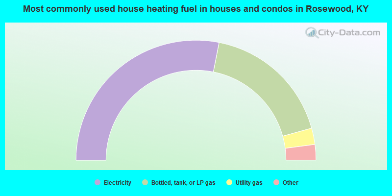
- 56.2%Electricity
- 35.2%Bottled, tank, or LP gas
- 4.4%Utility gas
- 3.1%Wood
- 1.1%Other fuel
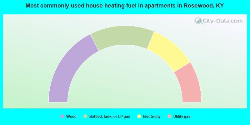
- 35.0%Wood
- 27.5%Bottled, tank, or LP gas
- 20.0%Electricity
- 17.5%Utility gas
Rosewood compared to Kentucky state average:
- Median house value below state average.
- Unemployed percentage below state average.
- Black race population percentage significantly below state average.
- Hispanic race population percentage significantly below state average.
- Foreign-born population percentage significantly below state average.
- Renting percentage significantly below state average.
- Length of stay since moving in significantly above state average.
- Number of rooms per house significantly below state average.
- House age significantly below state average.
- Percentage of population with a bachelor's degree or higher significantly below state average.