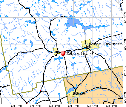
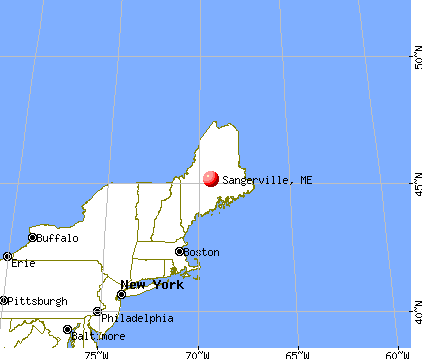
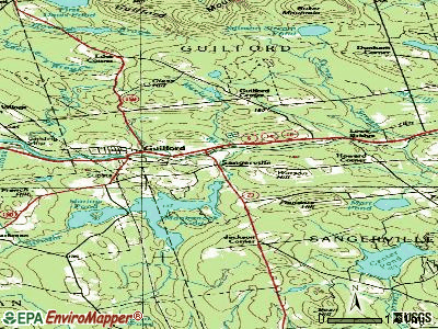
Sangerville, Maine

Submit your own pictures of this town and show them to the world
- OSM Map
- General Map
- Google Map
- MSN Map
Population change since 2000: +5.7%
 |
| Males: 649 | |
| Females: 694 |
| Median resident age: | 48.6 years |
| Maine median age: | 43.0 years |
Zip codes: 04479.
| Sangerville: | $52,386 |
| ME: | $69,543 |
Estimated per capita income in 2022: $33,134 (it was $13,984 in 2000)
Sangerville town income, earnings, and wages data
Estimated median house or condo value in 2022: $177,625 (it was $68,300 in 2000)
| Sangerville: | $177,625 |
| ME: | $290,600 |
Mean prices in 2022: all housing units: $203,844; detached houses: $217,964; townhouses or other attached units: $250,113; in 2-unit structures: $253,343; in 3-to-4-unit structures: $283,591; in 5-or-more-unit structures: $146,783; mobile homes: $82,683
Detailed information about poverty and poor residents in Sangerville, ME
Compare current foreclosures near Sangerville, ME:
| Photo | Address | Area | Beds / Baths | Price | Details |
|---|---|---|---|---|---|

|
#1
Silvers Mills Rd
Sangerville, ME 04479
|
- sq. feet
|
- baths - beds |
show details | |

|
#2
Douty Hill Rd
Sangerville, ME 04479
|
- sq. feet
|
- baths - beds |
show details | |

|
#3
Grange St
Dover Foxcroft, ME 04426
|
- sq. feet
|
4 baths 4 beds |
show details | |

|
#4
Pleasant St
Dover Foxcroft, ME 04426
|
1,560 sq. feet
|
2 baths 4 beds |
show details | |

|
#5
Main St
Corinth, ME 04427
|
1,573 sq. feet
|
2 baths 3 beds |
show details | |

|
#6
Newport Rd
Corinna, ME 04928
|
756 sq. feet
|
1 baths 3 beds |
show details | |

|
#7
Abbot Rd
Abbot, ME 04406
|
- sq. feet
|
- baths - beds |
show details | |

|
#8
Morison Ave
Corinth, ME 04427
|
- sq. feet
|
- baths - beds |
show details | |

|
#9
Exeter Rd
Corinth, ME 04427
|
- sq. feet
|
- baths - beds |
show details | |

|
#10
Chadbourne Rd
Harmony, ME 04942
|
- sq. feet
|
- baths - beds |
show details |
| Photo | Address | Area | Beds / Baths | Price | Details |
|---|---|---|---|---|---|

|
#11
Milo Rd
Sebec, ME 04481
|
- sq. feet
|
- baths - beds |
show details | |

|
#12
Finson Rd
Saint Albans, ME 04971
|
- sq. feet
|
- baths - beds |
show details | |

|
#13
Pleasant St
Guilford, ME 04443
|
- sq. feet
|
- baths - beds |
show details | |

|
#14
Milo Rd
Sebec, ME 04481
|
- sq. feet
|
- baths - beds |
show details | |

|
#15
Mcnally Rd
Saint Albans, ME 04971
|
- sq. feet
|
- baths - beds |
show details | |

|
#16
Mud Pond Dr
Harmony, ME 04942
|
- sq. feet
|
- baths - beds |
show details | |

|
#17
Grandview Rd
Saint Albans, ME 04971
|
- sq. feet
|
- baths - beds |
show details | |

|
#18
Airport Rd
Dexter, ME 04930
|
- sq. feet
|
- baths - beds |
show details | |

|
#19
Greeley Rd
Garland, ME 04939
|
- sq. feet
|
- baths - beds |
show details | |

|
#20
Dexter St
Dexter, ME 04930
|
- sq. feet
|
- baths - beds |
show details |
| Photo | Address | Area | Beds / Baths | Price | Details |
|---|---|---|---|---|---|

|
#21
Hudson Rd
Corinth, ME 04427
|
- sq. feet
|
- baths - beds |
show details | |

|
#22
Todds Corner Rd
Saint Albans, ME 04971
|
- sq. feet
|
- baths - beds |
show details | |

|
Check over 1 million property listings on Foreclosure.com!
|
browse all offers | |||

- 1,29796.6%White alone
- 171.3%Two or more races
- 151.1%American Indian alone
- 50.4%Hispanic
- 40.3%Black alone
- 30.2%Asian alone
- 20.1%Other race alone

Races in Sangerville detailed stats: ancestries, foreign born residents, place of birth
According to our research of Maine and other state lists, there were 3 registered sex offenders living in Sangerville, Maine as of June 17, 2024.
The ratio of all residents to sex offenders in Sangerville is 448 to 1.
The ratio of registered sex offenders to all residents in this city is near the state average.
 Recent articles from our blog. Our writers, many of them Ph.D. graduates or candidates, create easy-to-read articles on a wide variety of topics.


Latest news from Sangerville, ME collected exclusively by city-data.com from local newspapers, TV, and radio stations
Ancestries: English (33.1%), French (23.3%), Irish (15.5%), German (6.5%), United States (5.0%), Scottish (4.6%).
Current Local Time: EST time zone
Incorporated on 06/13/1814
Elevation: 518 feet
Land area: 38.5 square miles.
Population density: 35 people per square mile (very low).
14 residents are foreign born
| This town: | 1.1% |
| Maine: | 2.9% |
| Sangerville town: | 1.0% ($692) |
| Maine: | 1.5% ($1,417) |
Nearest city with pop. 50,000+: Portland, ME  (111.5 miles , pop. 64,249).
Nearest city with pop. 200,000+: Boston, MA (213.2 miles , pop. 589,141).
Nearest city with pop. 1,000,000+: Bronx, NY (375.1 miles , pop. 1,332,650).
Nearest cities:
), )Latitude: 45.12 N, Longitude: 69.31 W
Area code commonly used in this area: 207

| Here: | 7.4% |
| Maine: | 3.4% |


- Miscellaneous manufacturing (9.5%)
- Educational services (9.1%)
- Health care (9.0%)
- Textile mills & textile products (7.7%)
- Wood products (6.5%)
- Construction (5.9%)
- Public administration (5.2%)

- Construction (9.8%)
- Miscellaneous manufacturing (9.2%)
- Textile mills & textile products (8.0%)
- Wood products (7.7%)
- Agriculture, forestry, fishing & hunting (7.1%)
- Accommodation & food services (6.4%)
- Public administration (5.2%)

- Health care (18.4%)
- Educational services (14.5%)
- Miscellaneous manufacturing (9.8%)
- Textile mills & textile products (7.5%)
- Department & other general merchandise stores (6.7%)
- Wood products (5.1%)
- Public administration (5.1%)

- Other production occupations, including supervisors (7.4%)
- Textile, apparel, and furnishings workers (4.6%)
- Material recording, scheduling, dispatching, and distributing workers (4.0%)
- Other sales and related occupations, including supervisors (4.0%)
- Preschool, kindergarten, elementary, and middle school teachers (3.8%)
- Electrical equipment mechanics and other installation, maintenance, and repair workers, including supervisors (3.6%)
- Cooks and food preparation workers (3.4%)

- Other production occupations, including supervisors (8.3%)
- Electrical equipment mechanics and other installation, maintenance, and repair workers, including supervisors (6.4%)
- Other sales and related occupations, including supervisors (5.8%)
- Material recording, scheduling, dispatching, and distributing workers (4.6%)
- Cooks and food preparation workers (4.3%)
- Vehicle and mobile equipment mechanics, installers, and repairers (3.7%)
- Fishing, hunting, and forestry occupations (3.4%)

- Textile, apparel, and furnishings workers (7.5%)
- Other office and administrative support workers, including supervisors (6.7%)
- Secretaries and administrative assistants (6.7%)
- Preschool, kindergarten, elementary, and middle school teachers (6.3%)
- Other production occupations, including supervisors (6.3%)
- Cashiers (4.7%)
- Bookkeeping, accounting, and auditing clerks (4.3%)
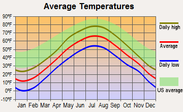
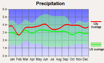
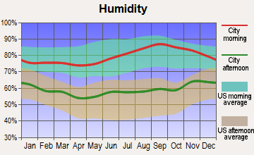
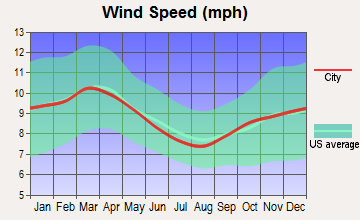
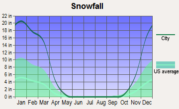
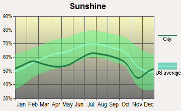
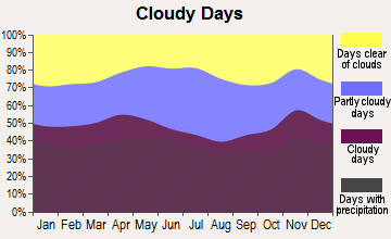
Average climate in Sangerville, Maine
Based on data reported by over 4,000 weather stations


Earthquake activity:
Sangerville-area historical earthquake activity is significantly above Maine state average. It is 81% smaller than the overall U.S. average.On 4/20/2002 at 10:50:47, a magnitude 5.3 (5.3 ML, Depth: 3.0 mi, Class: Moderate, Intensity: VI - VII) earthquake occurred 219.3 miles away from Sangerville center
On 4/20/2002 at 10:50:47, a magnitude 5.2 (5.2 MB, 4.2 MS, 5.2 MW, 5.0 MW) earthquake occurred 220.7 miles away from Sangerville center
On 10/16/2012 at 23:12:25, a magnitude 4.7 (4.7 ML, Depth: 10.0 mi, Class: Light, Intensity: IV - V) earthquake occurred 124.8 miles away from the city center
On 10/7/1983 at 10:18:46, a magnitude 5.3 (5.1 MB, 5.3 LG, 5.1 ML) earthquake occurred 260.9 miles away from Sangerville center
On 1/19/1982 at 00:14:42, a magnitude 4.7 (4.5 MB, 4.7 MD, 4.5 LG) earthquake occurred 159.5 miles away from Sangerville center
On 2/26/1999 at 03:38:43, a magnitude 3.8 (3.8 LG, Depth: 2.0 mi, Class: Light, Intensity: II - III) earthquake occurred 45.7 miles away from Sangerville center
Magnitude types: regional Lg-wave magnitude (LG), body-wave magnitude (MB), duration magnitude (MD), local magnitude (ML), surface-wave magnitude (MS), moment magnitude (MW)
Natural disasters:
The number of natural disasters in Piscataquis County (22) is greater than the US average (15).Major Disasters (Presidential) Declared: 15
Emergencies Declared: 6
Causes of natural disasters: Floods: 13, Storms: 12, Snows: 7, Heavy Rains: 2, Blizzard: 1, Ice Storm: 1, Landslide: 1, Snowfall: 1, Wind: 1, Winter Storm: 1, Other: 2 (Note: some incidents may be assigned to more than one category).
Hospitals and medical centers near Sangerville:
- MAYO REGIONAL HOSPITAL Critical Access Hospitals (about 6 miles away; DOVER FOXCROFT, ME)
- HIBBARD NURSING HOME (Nursing Home, about 6 miles away; DOVER FOXCROFT, ME)
- DEXTER HEALTH CARE (Nursing Home, about 7 miles away; DEXTER, ME)
- SQUARE ROAD GROUP HOME (Hospital, about 15 miles away; SAINT ALBANS, ME)
Airports located in Sangerville:
- Morrel Field Airport (ME32) (Runways: 1)
Colleges/universities with over 2000 students nearest to Sangerville:
- Husson University (about 33 miles; Bangor, ME; Full-time enrollment: 2,421)
- University of Maine (about 35 miles; Orono, ME; FT enrollment: 8,931)
- University of Maine at Farmington (about 52 miles; Farmington, ME; FT enrollment: 2,036)
- University of Maine at Augusta (about 60 miles; Augusta, ME; FT enrollment: 3,204)
- Saint Joseph's College of Maine (about 107 miles; Standish, ME; FT enrollment: 2,010)
- Southern Maine Community College (about 112 miles; South Portland, ME; FT enrollment: 4,666)
- University of Southern Maine (about 112 miles; Portland, ME; FT enrollment: 6,647)
Points of interest:
Notable location: Sangerville Volunteer Fire Department (A). Display/hide its location on the map
Church in Sangerville: First Unitarian Universalist Church of Sangerville (A). Display/hide its location on the map
Cemeteries: Town House Cemetery (1), Jackman Corner Cemetery (2), Gilman Cemetery (3), Village Cemetery (4). Display/hide their locations on the map
Lakes, reservoirs, and swamps: Center Pond (A), Marr Pond (B), Carlton Stream Reservoir (C), Lougee Bog (D), Brown Bog (E), Grey Bog (F). Display/hide their locations on the map
Streams, rivers, and creeks: Alder Brook (A), Townhouse Brook (B), Sucker Brook (C), Flanders Brook (D), Oak Brook (E), French Mills Brook (F), Carlton Stream (G), Black Stream (H). Display/hide their locations on the map
| This town: | 2.2 people |
| Maine: | 2.3 people |
| This town: | 65.6% |
| Whole state: | 62.9% |
| This town: | 8.5% |
| Whole state: | 9.4% |
Likely homosexual households (counted as self-reported same-sex unmarried-partner households)
- Lesbian couples: 0.0% of all households
- Gay men: 0.3% of all households
| This town: | 11.5% |
| Whole state: | 10.9% |
| This town: | 3.4% |
| Whole state: | 4.1% |
For population 15 years and over in Sangerville:

- Never married: 16.3%
- Now married: 58.5%
- Separated: 1.1%
- Widowed: 11.7%
- Divorced: 12.4%
For population 25 years and over in Sangerville:
- High school or higher: 83.3%
- Bachelor's degree or higher: 8.7%
- Graduate or professional degree: 3.0%
- Unemployed: 6.4%
- Mean travel time to work (commute): 18.8 minutes


| Here: | 8.9 |
| Maine average: | 11.2 |
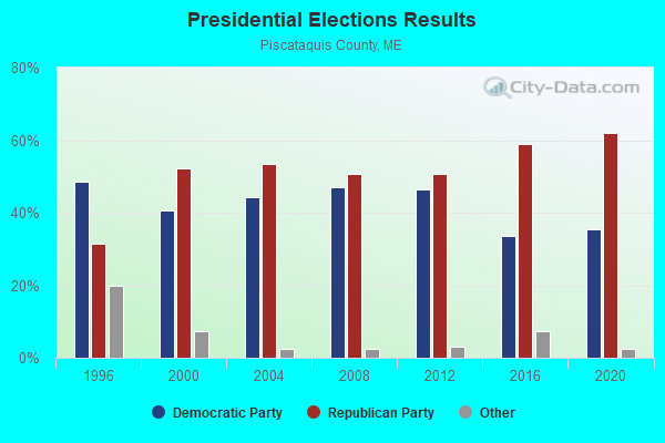
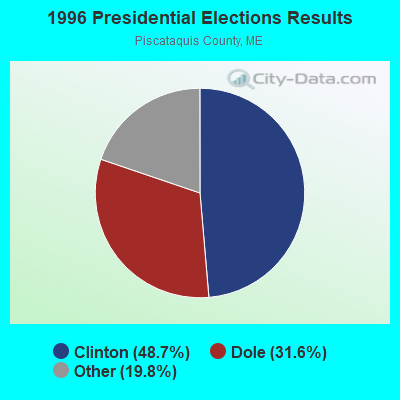
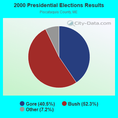


Graphs represent county-level data. Detailed 2008 Election Results
Religion statistics for Sangerville, ME (based on Piscataquis County data)
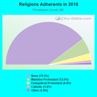
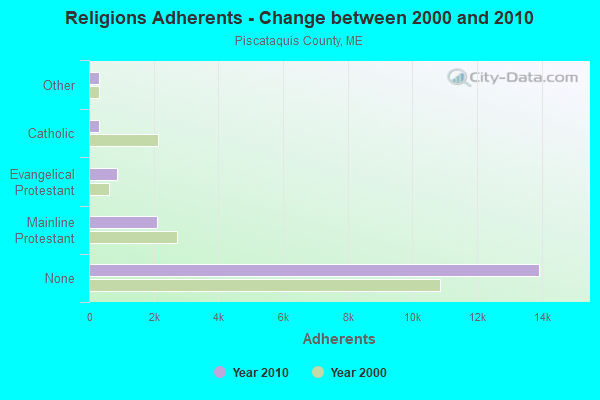
| Religion | Adherents | Congregations |
|---|---|---|
| Mainline Protestant | 2,108 | 13 |
| Evangelical Protestant | 855 | 13 |
| Catholic | 320 | 3 |
| Other | 318 | 5 |
| None | 13,934 | - |
Food Environment Statistics:
| This county: | 5.24 / 10,000 pop. |
| State: | 2.80 / 10,000 pop. |
| Piscataquis County: | 4.08 / 10,000 pop. |
| State: | 2.20 / 10,000 pop. |
| This county: | 8.74 / 10,000 pop. |
| Maine: | 5.75 / 10,000 pop. |
| Piscataquis County: | 10.49 / 10,000 pop. |
| State: | 11.02 / 10,000 pop. |
| Piscataquis County: | 8.4% |
| Maine: | 8.2% |
| Piscataquis County: | 27.5% |
| Maine: | 25.0% |
Strongest AM radio stations in Sangerville:
- WSKW (1160 AM; 10 kW; SKOWHEGAN, ME; Owner: MOUNTAIN WIRELESS, INCORPORATED)
- WZON (620 AM; 5 kW; BANGOR, ME; Owner: THE ZONE CORPORATION)
- WABI (910 AM; 5 kW; BANGOR, ME; Owner: CLEAR CHANNEL BROADCASTING LICENSES, INC.)
- WTME (780 AM; 10 kW; RUMFORD, ME; Owner: MOUNTAIN VALLEY BROADCASTING, INC.)
- WRKO (680 AM; 50 kW; BOSTON, MA; Owner: ENTERCOM BOSTON LICENSE, LLC)
- WEEI (850 AM; 50 kW; BOSTON, MA; Owner: ENTERCOM BOSTON LICENSE, LLC)
- WCHP (760 AM; 35 kW; CHAMPLAIN, NY; Owner: CHAMPLAIN RADIO, INC.)
- WBZ (1030 AM; 50 kW; BOSTON, MA; Owner: INFINITY BROADCASTING OPERATIONS, INC.)
- WNNZ (640 AM; 50 kW; WESTFIELD, MA; Owner: CLEAR CHANNEL BROADCASTING LICENSES, INC.)
- WCRN (830 AM; 50 kW; WORCESTER, MA; Owner: CARTER BROADCASTING CORPORATION)
- WDEA (1370 AM; 5 kW; ELLSWORTH, ME; Owner: CUMULUS LICENSING CORP.)
- WFAU (1280 AM; 5 kW; GARDINER, ME; Owner: CAPSTAR TX LIMITED PARTNERSHIP)
- WKOX (1200 AM; 50 kW; FRAMINGHAM, MA; Owner: CAPSTAR TX LIMITED PARTNERSHIP)
Strongest FM radio stations in Sangerville:
- WQCB (106.5 FM; BREWER, ME; Owner: CUMULUS LICENSING CORP.)
- WGUY (102.1 FM; DEXTER, ME; Owner: CONCORD MEDIA GROUP, INC.)
- WDME-FM (103.1 FM; DOVER-FOXCROFT, ME; Owner: THE ZONE CORPORATION)
- WTOS-FM (105.1 FM; SKOWHEGAN, ME; Owner: CAPSTAR TX LIMITED PARTNERSHIP)
- WVOM (103.9 FM; HOWLAND, ME; Owner: CLEAR CHANNEL BROADCASTING LICENSES, INC.)
- WWBX (97.1 FM; BANGOR, ME; Owner: CLEAR CHANNEL BROADCASTING LICENSES, INC.)
- WHCF (88.5 FM; BANGOR, ME; Owner: BANGOR BAPTIST CHURCH)
- WBFB (104.7 FM; BELFAST, ME; Owner: CLEAR CHANNEL BROADCASTING LICENSES, INC.)
- WJCX (99.5 FM; PITTSFIELD, ME; Owner: CSN INTERNATIONAL)
- WBZN (107.3 FM; OLD TOWN, ME; Owner: CUMULUS LICENSING CORP.)
- WKIT-FM (100.3 FM; BREWER, ME; Owner: THE ZONE CORPORATION)
- WHQO (107.9 FM; SKOWHEGAN, ME; Owner: MOUNTAIN WIRELESS, INC.)
TV broadcast stations around Sangerville:
- W27CE (Channel 19; DOVER-FOXCROFT, ME; Owner: TRINITY BROADCASTING NETWORK)
- WABI-TV (Channel 5; BANGOR, ME; Owner: COMMUNITY BROADCASTING SERVICE)
Medal of Honor Recipients
Medal of Honor Recipients born in Sangerville: Charles A. Clark, Otis O. Roberts.
Sangerville fatal accident list:
Mar 28, 2003 11:19 PM, Sr-23, Vehicles: 1, Persons: 1, Fatalities: 1, Drunk persons involved: 1
Sep 30, 1999 01:30 PM, Sr-23, Vehicles: 1, Persons: 1, Fatalities: 1
Mar 20, 1990 07:30 AM, 18161865, Vehicles: 2, Persons: 2, Fatalities: 1
Aug 11, 1987 08:40 AM, 50145015, Vehicles: 1, Persons: 1, Fatalities: 1, Drunk persons involved: 1
- National Bridge Inventory (NBI) Statistics
- 6Number of bridges
- 39ft / 11.9mTotal length
- 808,583Total average daily traffic
- 40,426Total average daily truck traffic
- 11,046Total future (year 2036) average daily traffic
FCC Registered Antenna Towers:
5- Kristopher D Williams, 54 Townhouse Rd (Lat: 45.133750 Lon: -69.338389), Type: 92.0, Structure height: 23021 m, Overall height: 91.4 m, Registrant: Holland & Knight LLP, Peter.Connolly@hklaw.Com, , Washi-ngton, Phone: (202) 955-3000
- Kristopher D Williams, 54 Townhouse Rd (Lat: 45.133750 Lon: -69.338389), Type: 92.0, Structure height: 23021 m, Overall height: 91.4 m, Registrant: Holland & Knight LLP, Peter.Connolly@hklaw.Com, , Washi-ngton, Phone: (202) 955-3000
- Cayla Gamble, 54 Townhouse Rd (Lat: 45.133750 Lon: -69.338389), Type: 92.0, Structure height: 23021 m, Overall height: 91.4 m, Registrant: Wilkinson Barker Knauer, LLP, Gwerner@wbklaw.Com, , Washi-ngton, Phone: (202) 383-3420
- Cayla Gamble, 74 Townhouse Rd (Lat: 45.133750 Lon: -69.338389), Type: 92.0, Structure height: 23021 m, Overall height: 91.4 m, Registrant: Wilkinson Barker Knauer, LLP, Gwerner@wbklaw.Com, , Washi-ngton, Phone: (202) 383-3420
- Cayla Gamble, 74 Townhouse Rd (Lat: 45.133750 Lon: -69.338389), Type: 92.0, Structure height: 23021 m, Overall height: 91.4 m, Registrant: Wilkinson Barker Knauer, LLP, Gwerner@wbklaw.Com, , Washi-ngton, Phone: (202) 383-3420
FCC Registered Broadcast Land Mobile Towers:
2- Fire Station (Lat: 45.164778 Lon: -69.357833), Call Sign: KXZ568,
Assigned Frequencies: 153.920 MHz, Grant Date: 02/13/1995, Expiration Date: 02/27/2000, Cancellation Date: 10/29/2000, Registrant: Sangerville, Town Of, Municipal Office, Sangerville, ME 04479, Phone: (207) 876-2814
- Pump Station #5 - Mill Street (Lat: 45.168778 Lon: -69.354944), Type: Building, Structure height: 3.6 m, Overall height: 5.4 m, Call Sign: WQHV577,
Assigned Frequencies: 154.478 MHz, Grant Date: 11/19/2007, Expiration Date: 11/19/2017, Cancellation Date: 01/20/2018, Certifier: Frank Ruksznis, Registrant: Electrical Installations, Inc., 397 Whittier Hwy., Moultonboro, NH 03254, Phone: (603) 253-4525, Fax: (603) 253-6284
FCC Registered Microwave Towers:
2- SANGERVILLE, 54 Townhouse Rd (Lat: 45.133750 Lon: -69.338389), Type: Gtower, Structure height: 91.4 m, Overall height: 92 m, Call Sign: WMQ588,
Assigned Frequencies: 6004.50 MHz, 6004.50 MHz, 6004.50 MHz, 6004.50 MHz, Grant Date: 03/16/2021, Expiration Date: 02/01/2031, Cancellation Date: 09/20/2023, Registrant: Holland & Knight LLP, 800 17th Street, N.W., Suite #1100, Washington, DC 20006-3906, Phone: (202) 955-3000, Fax: (202) 955-5564, Email:
- Sangerville, 54 Townhouse Rd (Lat: 45.133750 Lon: -69.338389), Type: Gtower, Structure height: 92 m, Overall height: 95.7 m, Call Sign: WQUR781,
Assigned Frequencies: 11265.0 MHz, 19475.0 MHz, 11265.0 MHz, 19475.0 MHz, 11265.0 MHz, 19475.0 MHz, 11265.0 MHz, 19475.0 MHz, 11265.0 MHz, 19475.0 MHz... (+17 more), Grant Date: 09/23/2014, Expiration Date: 09/23/2024, Cancellation Date: 05/18/2020, Certifier: Jessica B Lyons, Registrant: At&t Services, Inc., 208 S. Akard St., Room 2100, Dallas, TX 75202, Phone: (855) 699-7073, Email:
FCC Registered Amateur Radio Licenses:
7- Call Sign: N1MDS, Licensee ID: L00653589, Grant Date: 07/25/2023, Expiration Date: 07/20/2033, Registrant: Glen G Larson, 2 Mill St, Sangerville, ME 04479
- Call Sign: N1PGX, Grant Date: 06/01/1993, Expiration Date: 06/01/2003, Cancellation Date: 06/02/2005, Registrant: Harold C Rolfe, Rfd 1 Mb 518a, Sangerville, ME 04479
- Call Sign: N1XRJ, Licensee ID: L01168374, Grant Date: 07/01/2006, Expiration Date: 07/06/2016, Cancellation Date: 07/07/2018, Registrant: Arnold R Corson, Sangerville, ME 04479
- Call Sign: WB1HBV, Licensee ID: L00287489, Grant Date: 07/18/2018, Expiration Date: 08/07/2028, Certifier: Wayne G Depew, Registrant: Wayne G Depew, 94 Anderson Rd, Sangerville, ME 04479
- Call Sign: AA1JR, Previous Call Sign: N1KGT, Licensee ID: L00131724, Grant Date: 10/08/2020, Expiration Date: 12/19/2030, Certifier: Joseph A Ranagan, Registrant: Joseph A Ranagan, 394 Frenchs Mill Rd, Sangerville, ME 04479-3544
- Call Sign: N1ZB, Previous Call Sign: AB1BC, Licensee ID: L00493721, Grant Date: 06/07/2022, Expiration Date: 08/20/2032, Certifier: Michael W Butler, Registrant: Michael W Butler, 923 North Dexter Rd, Sangerville, ME 04479
- Call Sign: KB1UCU, Licensee ID: L01563446, Grant Date: 04/21/2010, Expiration Date: 04/21/2020, Cancellation Date: 04/22/2022, Certifier: Sarah V Jarnecki, Registrant: Sarah V Jarnecki, Sangerville, ME 04479
FAA Registered Aircraft:
1- Aircraft: CESSNA 172M (Category: Land, Seats: 4, Weight: Up to 12,499 Pounds, Speed: 108 mph), Engine: LYCOMING 0-320 SERIES (180 HP) (4 Cycle)
N-Number: 9931Q, N9931Q, N-9931Q, Serial Number: 17265875, Year manufactured: 1975, Airworthiness Date: 09/04/1975, Certificate Issue Date: 12/11/2020
Registrant (Co-Owned): Glen G Larson, Po Box 114, Sangerville, ME 04479, Other Owners: George R Dean

- 77.9%Fuel oil, kerosene, etc.
- 18.6%Wood
- 2.1%Bottled, tank, or LP gas
- 1.4%Electricity

- 55.5%Fuel oil, kerosene, etc.
- 34.5%Electricity
- 5.0%Bottled, tank, or LP gas
- 5.0%Wood
Sangerville compared to Maine state average:
- Median house value below state average.
- Unemployed percentage below state average.
- Black race population percentage significantly below state average.
- Hispanic race population percentage significantly below state average.
- Median age above state average.
- Foreign-born population percentage significantly below state average.
- Length of stay since moving in significantly above state average.
- Number of rooms per house significantly below state average.
- House age significantly below state average.
- Number of college students below state average.
- Percentage of population with a bachelor's degree or higher significantly below state average.

|
Total of 1 patent application in 2008-2024.