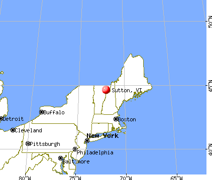
Sutton, Vermont
Submit your own pictures of this town and show them to the world
- OSM Map
- General Map
- Google Map
- MSN Map
Population change since 2000: +2.8%
 |
| Males: 551 | |
| Females: 478 |
| Median resident age: | 42.2 years |
| Vermont median age: | 45.8 years |
Zip codes: 05867.
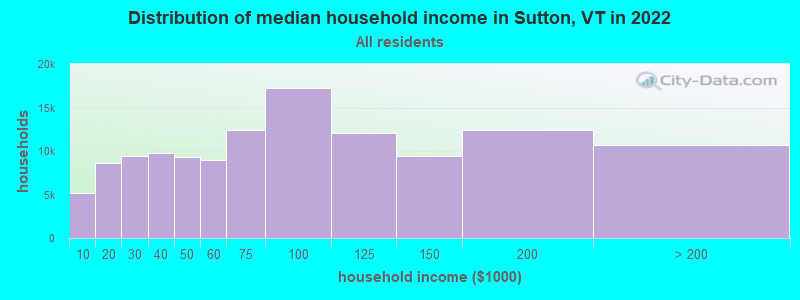
| Sutton: | $66,471 |
| VT: | $73,991 |
Estimated per capita income in 2022: $31,833 (it was $14,564 in 2000)
Sutton town income, earnings, and wages data
Estimated median house or condo value in 2022: $206,468 (it was $80,200 in 2000)
| Sutton: | $206,468 |
| VT: | $304,700 |
Mean prices in 2022: all housing units: $260,980; detached houses: $279,604; townhouses or other attached units: $224,498; in 2-unit structures: $313,991; in 3-to-4-unit structures: $254,854; in 5-or-more-unit structures: $182,529; mobile homes: $88,292; occupied boats, rvs, vans, etc.: $12,813
Detailed information about poverty and poor residents in Sutton, VT
Compare current foreclosures near Sutton, VT:
| Photo | Address | Area | Beds / Baths | Price | Details |
|---|---|---|---|---|---|

|
#1
Depot St
West Burke, VT 05871
|
1,320 sq. feet
|
2 baths 2 beds |
$205,000
|
show details |

|
#2
Vt Route 114
East Haven, VT 05837
|
2,469 sq. feet
|
1 baths 2 beds |
$38,000
|
show details |

|
#3
South St
Orleans, VT 05860
|
2,135 sq. feet
|
2 baths 3 beds |
$264,900
|
show details |

|
#4
Blake Pond Rd
Sheffield, VT 05866
|
- sq. feet
|
- baths - beds |
show details | |

|
#5
Ponemah Path
West Burke, VT 05871
|
- sq. feet
|
- baths - beds |
show details | |

|
#6
Vt Route 114
East Burke, VT 05832
|
- sq. feet
|
- baths - beds |
show details | |

|
#7
Hinman Rd
Glover, VT 05839
|
- sq. feet
|
- baths - beds |
show details | |

|
#8
Railroad St Ste 2
Saint Johnsbury, VT 05819
|
- sq. feet
|
- baths - beds |
show details | |

|
#9
Depot St
West Burke, VT 05871
|
- sq. feet
|
- baths - beds |
show details | |

|
#10
Clark St
Island Pond, VT 05846
|
- sq. feet
|
- baths - beds |
show details |
| Photo | Address | Area | Beds / Baths | Price | Details |
|---|---|---|---|---|---|

|
#11
A-B North Ave
Orleans, VT 05860
|
- sq. feet
|
- baths - beds |
show details | |

|
Check over 1 million property listings on Foreclosure.com!
|
browse all offers | |||

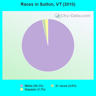
- 99196.3%White alone
- 212.0%Two or more races
- 171.7%Hispanic
Races in Sutton detailed stats: ancestries, foreign born residents, place of birth
According to our research of Vermont and other state lists, there were 7 registered sex offenders living in Sutton, Vermont as of June 16, 2024.
The ratio of all residents to sex offenders in Sutton is 147 to 1.
 Recent articles from our blog. Our writers, many of them Ph.D. graduates or candidates, create easy-to-read articles on a wide variety of topics.

 | Dated and out of style homes (34 replies) |
| Vermont Weather (3779 replies) |
| How much does Montreal influence Vermont? (25 replies) |
| Places for consideration (19 replies) |
| Young couple from TX looking to start life in VT (84 replies) |
| African Americam Moving To Vermont (23 replies) |
Latest news from Sutton, VT collected exclusively by city-data.com from local newspapers, TV, and radio stations
Ancestries: French (25.3%), English (24.1%), Irish (12.6%), United States (11.0%), German (5.4%), Italian (5.2%).
Current Local Time: EST time zone
Elevation: 1152 feet
Land area: 38.3 square miles.
Population density: 27 people per square mile (very low).
19 residents are foreign born
| This town: | 1.9% |
| Vermont: | 3.8% |
| Sutton town: | 1.6% ($1,298) |
| Vermont: | 2.0% ($2,196) |
Nearest city with pop. 50,000+: Portland, ME  (110.9 miles , pop. 64,249).
Nearest city with pop. 200,000+: Boston, MA (168.1 miles , pop. 589,141).
Nearest city with pop. 1,000,000+: Bronx, NY (279.5 miles , pop. 1,332,650).
Nearest cities:
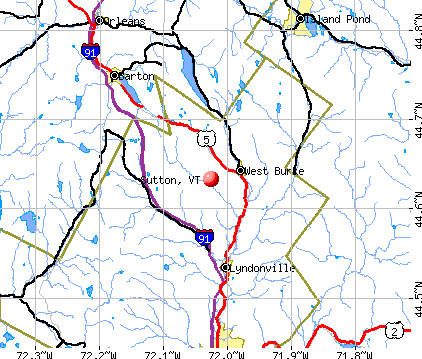
), ), ), )Latitude: 44.65 N, Longitude: 72.03 W
Area code commonly used in this area: 802

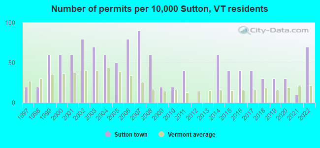
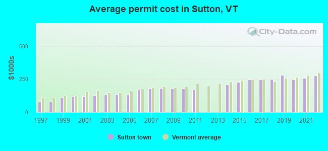
Single-family new house construction building permits:
- 2022: 7 buildings, average cost: $279,200
- 2021: 1 building, cost: $259,200
- 2020: 3 buildings, average cost: $248,200
- 2019: 3 buildings, average cost: $282,200
- 2018: 3 buildings, average cost: $249,800
- 2017: 4 buildings, average cost: $246,000
- 2016: 4 buildings, average cost: $246,000
- 2015: 4 buildings, average cost: $226,800
- 2014: 6 buildings, average cost: $211,200
- 2011: 4 buildings, average cost: $172,800
- 2010: 2 buildings, average cost: $178,900
- 2009: 2 buildings, average cost: $178,900
- 2008: 6 buildings, average cost: $182,400
- 2007: 9 buildings, average cost: $181,200
- 2006: 8 buildings, average cost: $171,000
- 2005: 5 buildings, average cost: $138,800
- 2004: 6 buildings, average cost: $138,800
- 2003: 7 buildings, average cost: $132,800
- 2002: 8 buildings, average cost: $130,700
- 2001: 6 buildings, average cost: $121,400
- 2000: 6 buildings, average cost: $118,000
- 1999: 6 buildings, average cost: $109,200
- 1998: 2 buildings, average cost: $79,500
- 1997: 2 buildings, average cost: $79,500
| Here: | 1.6% |
| Vermont: | 2.0% |
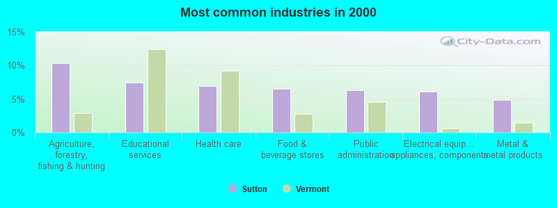
- Agriculture, forestry, fishing & hunting (10.3%)
- Educational services (7.5%)
- Health care (6.9%)
- Food & beverage stores (6.5%)
- Public administration (6.3%)
- Electrical equipment, appliances, components (6.1%)
- Metal & metal products (4.9%)
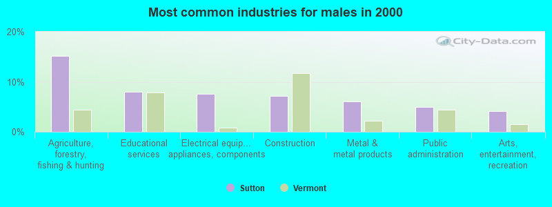
- Agriculture, forestry, fishing & hunting (15.2%)
- Educational services (8.0%)
- Electrical equipment, appliances, components (7.6%)
- Construction (7.2%)
- Metal & metal products (6.1%)
- Public administration (4.9%)
- Arts, entertainment, recreation (4.2%)
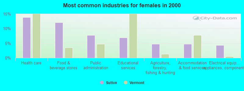
- Health care (13.9%)
- Food & beverage stores (12.1%)
- Public administration (7.8%)
- Educational services (6.9%)
- Agriculture, forestry, fishing & hunting (4.8%)
- Accommodation & food services (4.8%)
- Electrical equipment, appliances, components (4.3%)
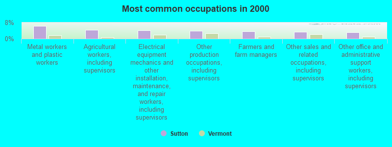
- Metal workers and plastic workers (6.3%)
- Agricultural workers, including supervisors (4.5%)
- Electrical equipment mechanics and other installation, maintenance, and repair workers, including supervisors (4.0%)
- Other production occupations, including supervisors (3.8%)
- Farmers and farm managers (3.6%)
- Other sales and related occupations, including supervisors (3.4%)
- Other office and administrative support workers, including supervisors (3.2%)
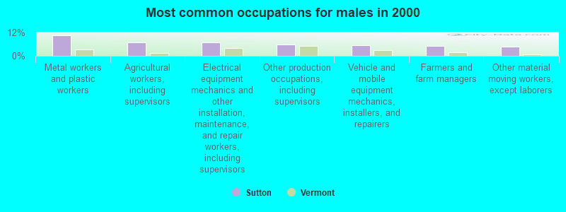
- Metal workers and plastic workers (10.6%)
- Agricultural workers, including supervisors (6.8%)
- Electrical equipment mechanics and other installation, maintenance, and repair workers, including supervisors (6.8%)
- Other production occupations, including supervisors (5.7%)
- Vehicle and mobile equipment mechanics, installers, and repairers (5.3%)
- Farmers and farm managers (4.9%)
- Other material moving workers, except laborers (4.6%)
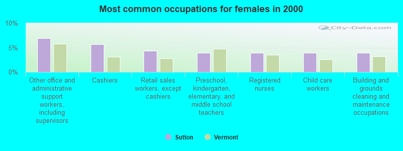
- Other office and administrative support workers, including supervisors (6.9%)
- Cashiers (5.6%)
- Retail sales workers, except cashiers (4.3%)
- Preschool, kindergarten, elementary, and middle school teachers (3.9%)
- Registered nurses (3.9%)
- Child care workers (3.9%)
- Building and grounds cleaning and maintenance occupations (3.9%)
Average climate in Sutton, Vermont
Based on data reported by over 4,000 weather stations


Earthquake activity:
Sutton-area historical earthquake activity is significantly above Vermont state average. It is 73% smaller than the overall U.S. average.On 4/20/2002 at 10:50:47, a magnitude 5.3 (5.3 ML, Depth: 3.0 mi, Class: Moderate, Intensity: VI - VII) earthquake occurred 82.8 miles away from the city center
On 4/20/2002 at 10:50:47, a magnitude 5.2 (5.2 MB, 4.2 MS, 5.2 MW, 5.0 MW) earthquake occurred 84.0 miles away from the city center
On 10/7/1983 at 10:18:46, a magnitude 5.3 (5.1 MB, 5.3 LG, 5.1 ML) earthquake occurred 124.3 miles away from the city center
On 1/19/1982 at 00:14:42, a magnitude 4.7 (4.5 MB, 4.7 MD, 4.5 LG, Class: Light, Intensity: IV - V) earthquake occurred 82.6 miles away from Sutton center
On 10/16/2012 at 23:12:25, a magnitude 4.7 (4.7 ML, Depth: 10.0 mi) earthquake occurred 100.0 miles away from Sutton center
On 6/16/1995 at 12:13:11, a magnitude 3.8 (3.8 LG, Depth: 3.1 mi, Class: Light, Intensity: II - III) earthquake occurred 26.1 miles away from the city center
Magnitude types: regional Lg-wave magnitude (LG), body-wave magnitude (MB), duration magnitude (MD), local magnitude (ML), surface-wave magnitude (MS), moment magnitude (MW)
Natural disasters:
The number of natural disasters in Caledonia County (24) is greater than the US average (15).Major Disasters (Presidential) Declared: 21
Emergencies Declared: 1
Causes of natural disasters: Floods: 19, Storms: 16, Heavy Rains: 2, Tropical Storms: 2, Winds: 2, Hurricane: 1, Landslide: 1, Tornado: 1, Winter Storm: 1, Other: 1 (Note: some incidents may be assigned to more than one category).
Hospitals and medical centers near Sutton:
- UNION HOUSE NURSING HOME (Nursing Home, about 10 miles away; GLOVER, VT)
- PINES REHAB AND HEALTH CTR (Nursing Home, about 10 miles away; LYNDONVILLE, VT)
- MAPLE LANE NURSING HOME (Nursing Home, about 12 miles away; BARTON, VT)
- CALEDONIA HOME HEALTH CARE (Home Health Center, about 15 miles away; SAINT JOHNSBURY, VT)
- FMC OF ST. JOHNSBURY DIALYSIS (Dialysis Facility, about 15 miles away; SAINT JOHNSBURY, VT)
- ST JOHNSBURY HEALTH AND REHAB (Nursing Home, about 15 miles away; SAINT JOHNSBURY, VT)
- NORTHEASTERN VERMONT REGIONAL HOSPITAL Critical Access Hospitals (about 15 miles away; SAINT JOHNSBURY, VT)
Colleges/universities with over 2000 students nearest to Sutton:
- Norwich University (about 48 miles; Northfield, VT; Full-time enrollment: 4,221)
- Saint Michael's College (about 57 miles; Colchester, VT; FT enrollment: 2,336)
- Community College of Vermont (about 58 miles; Winooski, VT; FT enrollment: 3,394)
- University of Vermont (about 59 miles; Burlington, VT; FT enrollment: 11,566)
- Champlain College (about 60 miles; Burlington, VT; FT enrollment: 2,623)
- Plymouth State University (about 65 miles; Plymouth, NH; FT enrollment: 4,838)
- Dartmouth College (about 67 miles; Hanover, NH; FT enrollment: 6,030)
Public elementary/middle school in Sutton:
- SUTTON VILLAGE SCHOOL (Students: 106, Location: 95 UNDERPASS ROAD, Grades: PK-8)
Points of interest:
Notable locations in Sutton: Sutton Station (A), East Sutton Ridge (B), Sutton Free Public Library (C), Sutton Fire Department (D). Display/hide their locations on the map
Cemeteries: Sutton Village Cemetery (1), South Ridge Cemetery (2), North Ridge Cemetery (3), East Ridge Cemetery (4). Display/hide their locations on the map
Lakes: Duck Pond (A), Dolloff Ponds (B), Kings Pond (C), Blake Pond (D), Bean Pond (E), Vail Pond (F), Marl Pond (G). Display/hide their locations on the map
Park in Sutton: Calendar Brook State Wildlife Management Area (1). Display/hide its location on the map
Birthplace of: Fred Mann (baseball) - Major League Baseball player, Henry Oscar Houghton - Publisher.
Drinking water stations with addresses in Sutton and their reported violations in the past:
SUTTON WATER SYSTEM (Address: CALENDAR BROOK RD , Population served: 190, Groundwater):Past health violations:Past monitoring violations:
- MCL, Average - In JAN-2014, Contaminant: Nitrate. Follow-up actions: St Formal NOV issued (JAN-29-2014), St Tech Assistance Visit (JAN-29-2014), St Public Notif requested (JAN-29-2014), St Public Notif received (FEB-06-2014)
- MCL, Monthly (TCR) - In JUN-2013, Contaminant: Coliform. Follow-up actions: St Public Notif requested (JUN-14-2013), St Formal NOV issued (JUN-14-2013), St Public Notif received (SEP-10-2013), St Compliance achieved (DEC-19-2013)
- MCL, Monthly (TCR) - In OCT-2011, Contaminant: Coliform. Follow-up actions: St Tech Assistance Visit (NOV-08-2011), St Formal NOV issued (NOV-08-2011), St Public Notif requested (NOV-08-2011), St Boil Water Order (NOV-08-2011), St Compliance achieved (NOV-10-2011)
- Follow-up Or Routine LCR Tap M/R - In OCT-01-2011, Contaminant: Lead and Copper Rule. Follow-up actions: St Formal NOV issued (FEB-21-2012), St Tech Assistance Visit (FEB-21-2012), St Public Notif requested (FEB-21-2012), St Public Notif received (JUN-20-2012)
- Follow-up Or Routine LCR Tap M/R - In JAN-01-1997, Contaminant: Lead and Copper Rule. Follow-up actions: St Violation/Reminder Notice (JUL-01-1997), St Compliance achieved (APR-26-2011)
- One routine major monitoring violation
- One minor monitoring violation
- One regular monitoring violation
| This town: | 2.5 people |
| Vermont: | 2.3 people |
| This town: | 72.0% |
| Whole state: | 62.5% |
| This town: | 11.4% |
| Whole state: | 9.2% |
Likely homosexual households (counted as self-reported same-sex unmarried-partner households)
- Lesbian couples: 1.0% of all households
- Gay men: 0.0% of all households
| This town: | 13.0% |
| Whole state: | 9.4% |
| This town: | 4.2% |
| Whole state: | 3.6% |
For population 15 years and over in Sutton:
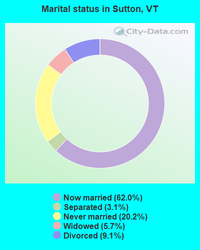
- Never married: 20.2%
- Now married: 62.0%
- Separated: 3.1%
- Widowed: 5.7%
- Divorced: 9.1%
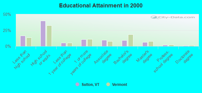
For population 25 years and over in Sutton:
- High school or higher: 83.5%
- Bachelor's degree or higher: 18.2%
- Graduate or professional degree: 9.1%
- Unemployed: 7.5%
- Mean travel time to work (commute): 24.4 minutes
| Here: | 11.0 |
| Vermont average: | 11.7 |
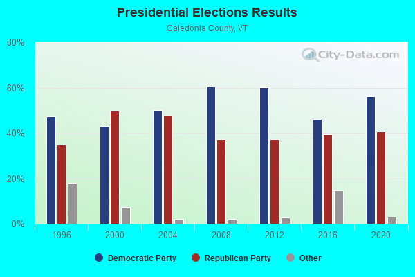
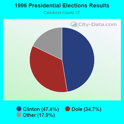
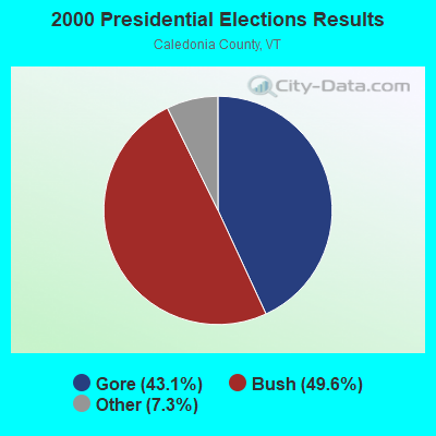
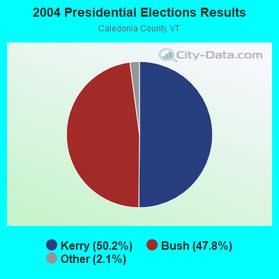
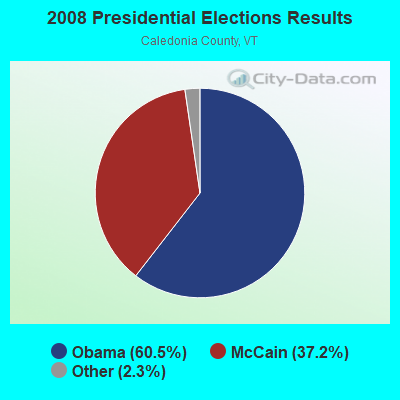
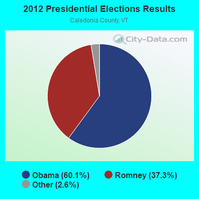
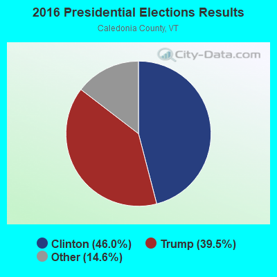
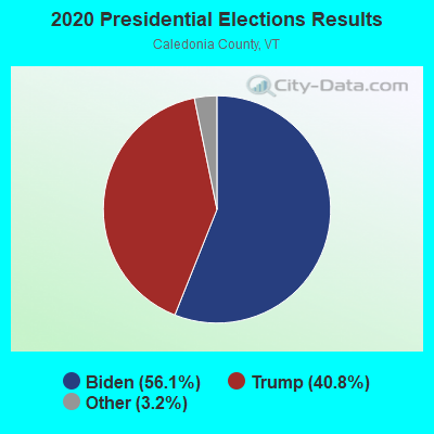
Graphs represent county-level data. Detailed 2008 Election Results
Religion statistics for Sutton, VT (based on Caledonia County data)
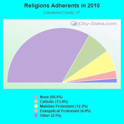
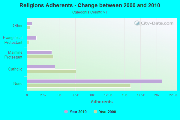
| Religion | Adherents | Congregations |
|---|---|---|
| Catholic | 4,355 | 6 |
| Mainline Protestant | 3,810 | 32 |
| Evangelical Protestant | 1,488 | 15 |
| Other | 780 | 9 |
| None | 20,794 | - |
Food Environment Statistics:
| This county: | 4.91 / 10,000 pop. |
| Vermont: | 3.84 / 10,000 pop. |
| Here: | 2.29 / 10,000 pop. |
| Vermont: | 1.95 / 10,000 pop. |
| This county: | 7.53 / 10,000 pop. |
| Vermont: | 6.40 / 10,000 pop. |
| Caledonia County: | 10.14 / 10,000 pop. |
| Vermont: | 11.52 / 10,000 pop. |
| Caledonia County: | 7.9% |
| State: | 6.8% |
| Caledonia County: | 24.6% |
| Vermont: | 22.3% |
| Here: | 11.5% |
| Vermont: | 13.3% |
Strongest AM radio stations in Sutton:
- WCHP (760 AM; 35 kW; CHAMPLAIN, NY; Owner: CHAMPLAIN RADIO, INC.)
- WDEV (550 AM; 5 kW; WATERBURY, VT; Owner: RADIO VERMONT, INC.)
- WTWN (1100 AM; daytime; 5 kW; WELLS RIVER, VT; Owner: PUFFER BROADCASTING, INC.)
- WICY (1490 AM; 50 kW; MALONE, NY; Owner: CARTIER COMMUNICATIONS INC.)
- WRKO (680 AM; 50 kW; BOSTON, MA; Owner: ENTERCOM BOSTON LICENSE, LLC)
- WSTJ (1340 AM; 1 kW; ST. JOHNSBURY, VT; Owner: VERMONT BROADCAST ASSOCIATES, INC.)
- WNNZ (640 AM; 50 kW; WESTFIELD, MA; Owner: CLEAR CHANNEL BROADCASTING LICENSES, INC.)
- WGY (810 AM; 50 kW; SCHENECTADY, NY; Owner: CLEAR CHANNEL BROADCASTING LICENSES, INC.)
- WTME (780 AM; 10 kW; RUMFORD, ME; Owner: MOUNTAIN VALLEY BROADCASTING, INC.)
- WVMT (620 AM; 5 kW; BURLINGTON, VT; Owner: SISON BROADCASTING, INC.)
- WCRN (830 AM; 50 kW; WORCESTER, MA; Owner: CARTER BROADCASTING CORPORATION)
- WEEI (850 AM; 50 kW; BOSTON, MA; Owner: ENTERCOM BOSTON LICENSE, LLC)
- WBZ (1030 AM; 50 kW; BOSTON, MA; Owner: INFINITY BROADCASTING OPERATIONS, INC.)
Strongest FM radio stations in Sutton:
- WGMT (97.7 FM; LYNDON, VT; Owner: VERMONT BROADCAST ASSOCIATES, INC.)
- W243AE (96.5 FM; ORLEANS, VT; Owner: CHRISTIAN MINISTRIES, INC.)
- WPKQ (103.7 FM; NORTH CONWAY, NH; Owner: CITADEL BROADCASTING COMPANY)
- WHOM (94.9 FM; MT. WASHINGTON, NH; Owner: CITADEL BROADCASTING COMPANY)
- WLKC (103.3 FM; WATERBURY, VT; Owner: RADIO BROADCASTING SERVICES, INC.)
- WDOT (95.7 FM; DANVILLE, VT; Owner: MONTPELIER BROADCASTING INC)
- WVPS (107.9 FM; BURLINGTON, VT; Owner: VERMONT PUBLIC RADIO)
- WEZF (92.9 FM; BURLINGTON, VT; Owner: CAPSTAR TX LIMITED PARTNERSHIP)
- WCVT (101.7 FM; STOWE, VT; Owner: RADIO VERMONT CLASSICS, L.L.C.)
- WMTK (106.3 FM; LITTLETON, NH; Owner: VERMONT BROADCAST ASSOCIATES, INC.)
- WCKJ (90.5 FM; ST. JOHNSBURY, VT; Owner: CHRISTIAN MINISTRIES, INC.)
- WKXH (105.5 FM; ST. JOHNSBURY, VT; Owner: VERMONT BROADCAST ASSOCIATES, INC.)
- WNCS (104.7 FM; MONTPELIER, VT; Owner: MONTPELIER BROADCASTING, INC.)
- WXXS (102.3 FM; LANCASTER, NH; Owner: BARRY P. LUNDERVILLE)
- WDEV-FM (96.1 FM; WARREN, VT; Owner: RADIO VERMONT, INC.)
- WMOO (92.1 FM; DERBY CENTER, VT; Owner: NORTHSTAR MEDIA, INC.)
- WVFM (105.7 FM; CAMPTON, NH; Owner: DEVON BROADCASTING COMPANY, INC.)
- WLTN-FM (96.7 FM; LISBON, NH; Owner: PROFILE BROADCASTING CO., INC.)
TV broadcast stations around Sutton:
- WLED-TV (Channel 49; LITTLETON, NH; Owner: UNIVERSITY OF NEW HAMPSHIRE)
- WVTB (Channel 20; ST. JOHNSBURY, VT; Owner: VERMONT ETV, INC.)
- W36CP (Channel 36; NEWPORT, VT; Owner: NYN, LLC)
Sutton fatal accident list:
Jan 14, 1982 05:45 PM, Sa1, Vehicles: 1, Persons: 2, Fatalities: 1
- National Bridge Inventory (NBI) Statistics
- 6Number of bridges
- 20ft / 6.2mTotal length
- $2,034,000Total costs
- 920Total average daily traffic
- 19Total average daily truck traffic
2002 - 2018 National Fire Incident Reporting System (NFIRS) incidents
- Fire incident types reported to NFIRS in Sutton, VT
- 9766.0%Structure Fires
- 2919.7%Outside Fires
- 138.8%Mobile Property/Vehicle Fires
- 85.4%Other
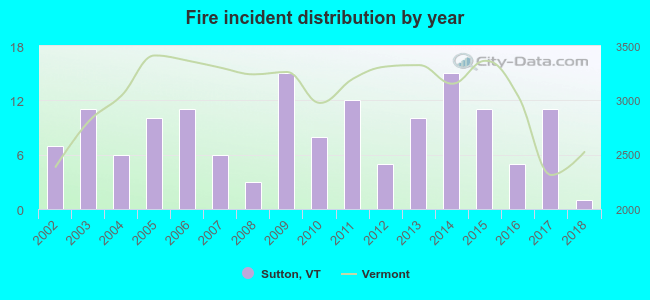 According to the data from the years 2002 - 2018 the average number of fire incidents per year is 9. The highest number of fires - 15 took place in 2009, and the least - 1 in 2018. The data has a decreasing trend.
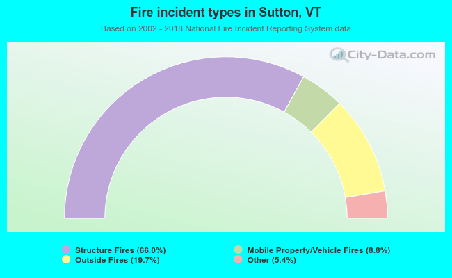 When looking into fire subcategories, the most incidents belonged to: Structure Fires (66.0%), and Outside Fires (19.7%).
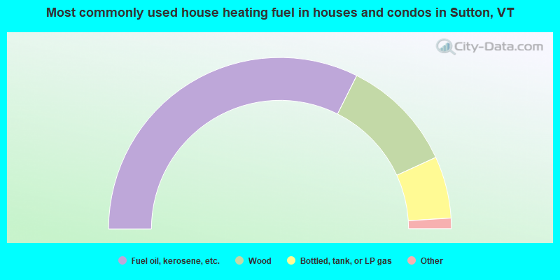
- 64.8%Fuel oil, kerosene, etc.
- 21.5%Wood
- 11.7%Bottled, tank, or LP gas
- 1.3%Coal or coke
- 0.7%Electricity
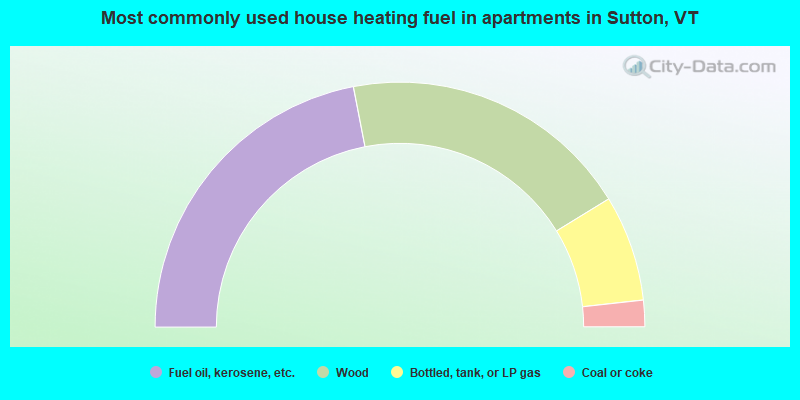
- 43.9%Fuel oil, kerosene, etc.
- 38.6%Wood
- 14.0%Bottled, tank, or LP gas
- 3.5%Coal or coke
Sutton compared to Vermont state average:
- Black race population percentage significantly below state average.
- Foreign-born population percentage significantly below state average.
- Renting percentage below state average.
- Length of stay since moving in significantly above state average.
- Number of rooms per house significantly below state average.
- House age significantly below state average.
- Percentage of population with a bachelor's degree or higher below state average.

|
Total of 2 patent applications in 2008-2024.