Trimbelle, Wisconsin
Submit your own pictures of this town and show them to the world
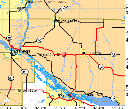
- OSM Map
- General Map
- Google Map
- MSN Map
Population change since 2000: +11.1%
 |
| Males: 875 | |
| Females: 804 |
| Median resident age: | 42.1 years |
| Wisconsin median age: | 42.6 years |
Zip codes: 54011.
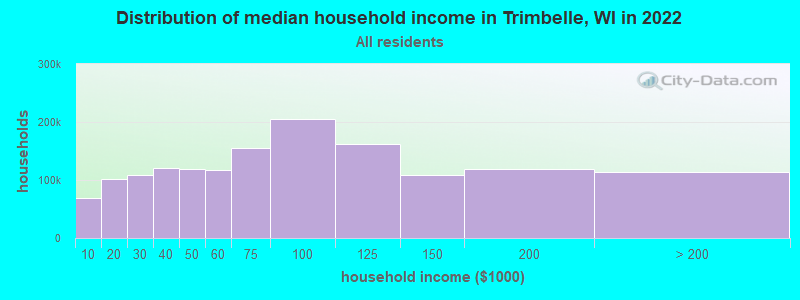
| Trimbelle: | $86,407 |
| WI: | $70,996 |
Estimated per capita income in 2022: $37,620 (it was $19,214 in 2000)
Trimbelle town income, earnings, and wages data
Estimated median house or condo value in 2022: $303,989 (it was $125,300 in 2000)
| Trimbelle: | $303,989 |
| WI: | $252,800 |
Detailed information about poverty and poor residents in Trimbelle, WI


- 1,65098.3%White alone
- 100.6%Hispanic
- 60.4%Asian alone
- 50.3%Black alone
- 50.3%Two or more races
- 30.2%American Indian alone
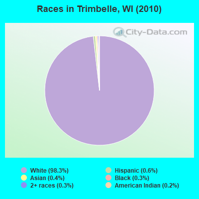
Races in Trimbelle detailed stats: ancestries, foreign born residents, place of birth
 Recent articles from our blog. Our writers, many of them Ph.D. graduates or candidates, create easy-to-read articles on a wide variety of topics.

Latest news from Trimbelle, WI collected exclusively by city-data.com from local newspapers, TV, and radio stations
Ancestries: German (52.7%), Norwegian (17.2%), Swedish (11.5%), Irish (10.7%), English (5.0%), Polish (4.4%).
Current Local Time: CST time zone
Elevation: 900 feet
Land area: 36.2 square miles.
Population density: 46 people per square mile (very low).
3 residents are foreign born
| This town: | 0.2% |
| Wisconsin: | 3.6% |
| Trimbelle town: | 1.6% ($2,000) |
| Wisconsin: | 2.0% ($2,245) |
Nearest city with pop. 50,000+: Eagan, MN  (30.4 miles , pop. 63,557).
Nearest city with pop. 200,000+: St. Paul, MN (30.9 miles , pop. 287,151).
Nearest city with pop. 1,000,000+: Chicago, IL (317.1 miles , pop. 2,896,016).
Nearest cities:
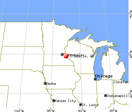
), ), ), ), ), ), Latitude: 44.74 N, Longitude: 92.56 W
Area code commonly used in this area: 715

| Here: | 3.5% |
| Wisconsin: | 2.7% |
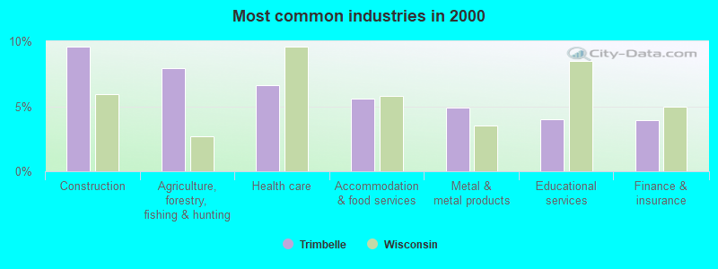
- Construction (9.6%)
- Agriculture, forestry, fishing & hunting (7.9%)
- Health care (6.6%)
- Accommodation & food services (5.6%)
- Metal & metal products (4.9%)
- Educational services (4.0%)
- Finance & insurance (3.9%)
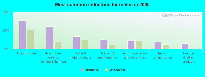
- Construction (15.4%)
- Agriculture, forestry, fishing & hunting (12.1%)
- Metal & metal products (6.8%)
- Repair & maintenance (5.1%)
- Accommodation & food services (4.5%)
- Truck transportation (3.9%)
- Leather & allied products (3.1%)
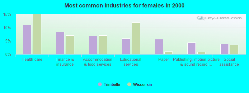
- Health care (11.1%)
- Finance & insurance (8.4%)
- Accommodation & food services (6.9%)
- Educational services (5.9%)
- Paper (5.7%)
- Publishing, motion picture & sound recording industries (4.4%)
- Social assistance (3.9%)
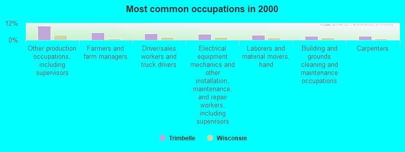
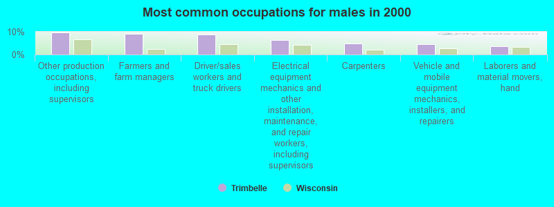
- Other production occupations, including supervisors (10.1%)
- Farmers and farm managers (5.6%)
- Driver/sales workers and truck drivers (4.8%)
- Electrical equipment mechanics and other installation, maintenance, and repair workers, including supervisors (4.3%)
- Laborers and material movers, hand (3.7%)
- Building and grounds cleaning and maintenance occupations (2.9%)
- Carpenters (2.9%)
- Other production occupations, including supervisors (9.6%)
- Farmers and farm managers (9.0%)
- Driver/sales workers and truck drivers (8.8%)
- Electrical equipment mechanics and other installation, maintenance, and repair workers, including supervisors (6.4%)
- Carpenters (4.9%)
- Vehicle and mobile equipment mechanics, installers, and repairers (4.5%)
- Laborers and material movers, hand (3.7%)
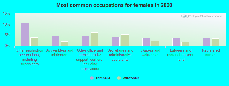
- Other production occupations, including supervisors (10.6%)
- Assemblers and fabricators (4.7%)
- Other office and administrative support workers, including supervisors (4.7%)
- Secretaries and administrative assistants (3.9%)
- Waiters and waitresses (3.7%)
- Laborers and material movers, hand (3.7%)
- Registered nurses (3.4%)
Average climate in Trimbelle, Wisconsin
Based on data reported by over 4,000 weather stations


(lower is better)
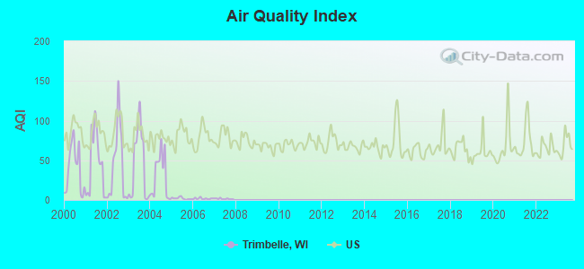
Air Quality Index (AQI) level in 2007 was 1.38. This is significantly better than average.
| City: | 1.38 |
| U.S.: | 72.56 |
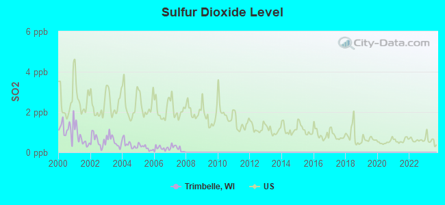
Sulfur Dioxide (SO2) [ppb] level in 2007 was 0.198. This is significantly better than average. Closest monitor was 8.1 miles away from the city center.
| City: | 0.198 |
| U.S.: | 1.515 |
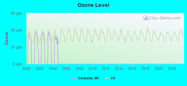
Ozone [ppb] level in 2001 was 30.5. This is about average. Closest monitor was 14.9 miles away from the city center.
| City: | 30.5 |
| U.S.: | 33.3 |
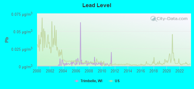
Lead (Pb) [µg/m3] level in 2010 was 0.00282. This is significantly better than average. Closest monitor was 8.1 miles away from the city center.
| City: | 0.00282 |
| U.S.: | 0.00931 |
Tornado activity:
Trimbelle-area historical tornado activity is slightly above Wisconsin state average. It is 28% greater than the overall U.S. average.
On 6/4/1958, a category F5 (max. wind speeds 261-318 mph) tornado 15.6 miles away from the Trimbelle town center killed 21 people and injured 74 people and caused between $5,000,000 and $50,000,000 in damages.
On 7/27/1987, a category F3 (max. wind speeds 158-206 mph) tornado 14.4 miles away from the town center caused between $500,000 and $5,000,000 in damages.
Earthquake activity:
Trimbelle-area historical earthquake activity is significantly above Wisconsin state average. It is 62% smaller than the overall U.S. average.On 7/9/1975 at 14:54:15, a magnitude 4.6 (4.6 MB, Class: Light, Intensity: IV - V) earthquake occurred 181.4 miles away from the city center
On 6/5/1993 at 01:24:53, a magnitude 4.1 (4.1 LG, Depth: 6.2 mi) earthquake occurred 193.0 miles away from Trimbelle center
On 3/4/1983 at 06:32:18, a magnitude 4.6 (4.4 MB, 4.6 LG, 4.4 ML) earthquake occurred 340.0 miles away from the city center
On 6/28/2004 at 06:10:52, a magnitude 4.2 (4.2 MW, Depth: 6.2 mi) earthquake occurred 292.7 miles away from Trimbelle center
On 10/20/1995 at 15:57:18, a magnitude 3.7 (3.7 LG, Depth: 3.1 mi, Class: Light, Intensity: II - III) earthquake occurred 221.7 miles away from Trimbelle center
On 2/9/1994 at 08:45:35, a magnitude 3.1 (3.1 LG, Depth: 3.1 mi) earthquake occurred 121.0 miles away from the city center
Magnitude types: regional Lg-wave magnitude (LG), body-wave magnitude (MB), local magnitude (ML), moment magnitude (MW)
Natural disasters:
The number of natural disasters in Pierce County (12) is smaller than the US average (15).Major Disasters (Presidential) Declared: 10
Emergencies Declared: 2
Causes of natural disasters: Floods: 8, Storms: 6, Tornadoes: 5, Heavy Rains: 2, Drought: 1, Flash Flood: 1, Hurricane: 1, Wind: 1, Other: 1 (Note: some incidents may be assigned to more than one category).

Hospitals and medical centers near Trimbelle:
- ELLSWORTH CARE CTR (Nursing Home, about 4 miles away; ELLSWORTH, WI)
- PIERCE CTY HOME CARE (Home Health Center, about 4 miles away; ELLSWORTH, WI)
- PIETY PLACE (Nursing Home, about 4 miles away; ELLSWORTH, WI)
- GRACE HEALTHCARE OF RIVER FALLS (Nursing Home, about 9 miles away; RIVER FALLS, WI)
- RIVER FALLS AREA HSPTL Critical Access Hospitals (about 9 miles away; RIVER FALLS, WI)
- RIVER FALLS AREA HOSP-KINNIC HOME DIV (Nursing Home, about 9 miles away; RIVER FALLS, WI)
- LUTHERAN HOME RIVER FALLS (Nursing Home, about 10 miles away; RIVER FALLS, WI)
Operable nuclear power plants near Trimbelle:
- 13 miles: Prairie Island 1 and 2 in Red Wing, MN.
Colleges/universities with over 2000 students nearest to Trimbelle:
- University of Wisconsin-River Falls (about 9 miles; River Falls, WI; Full-time enrollment: 5,868)
- Inver Hills Community College (about 26 miles; Inver Grove Heights, MN; FT enrollment: 4,049)
- Dakota County Technical College (about 26 miles; Rosemount, MN; FT enrollment: 2,478)
- Century College (about 30 miles; White Bear Lake, MN; FT enrollment: 7,393)
- Metropolitan State University (about 30 miles; Saint Paul, MN; FT enrollment: 6,159)
- Saint Paul College (about 31 miles; Saint Paul, MN; FT enrollment: 4,778)
- University of Wisconsin-Stout (about 33 miles; Menomonie, WI; FT enrollment: 8,120)
Points of interest:
Cemeteries: Beldenville Cemetery (1), Thurston Hill Cemetery (2). Display/hide their locations on the map
Creeks: Spring Creek (A), Goose Creek (B). Display/hide their locations on the map
| This town: | 2.6 people |
| Wisconsin: | 2.4 people |
| This town: | 75.9% |
| Whole state: | 64.4% |
| This town: | 8.0% |
| Whole state: | 7.3% |
Likely homosexual households (counted as self-reported same-sex unmarried-partner households)
- Lesbian couples: 0.3% of all households
- Gay men: 0.0% of all households
| This town: | 4.5% |
| Whole state: | 8.7% |
| This town: | 1.7% |
| Whole state: | 3.7% |
5 people in homes for the mentally retarded in 2000
For population 15 years and over in Trimbelle:
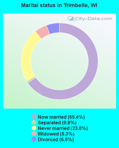
- Never married: 23.0%
- Now married: 65.4%
- Separated: 0.8%
- Widowed: 5.3%
- Divorced: 5.5%
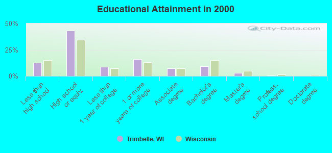
For population 25 years and over in Trimbelle:
- High school or higher: 87.3%
- Bachelor's degree or higher: 12.3%
- Graduate or professional degree: 3.3%
- Unemployed: 5.1%
- Mean travel time to work (commute): 27.4 minutes
| Here: | 8.0 |
| Wisconsin average: | 11.0 |
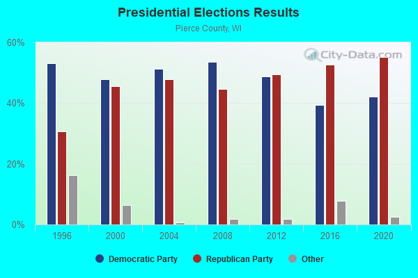
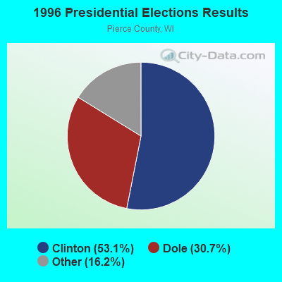
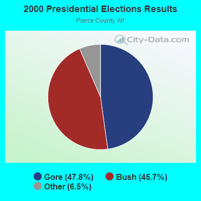
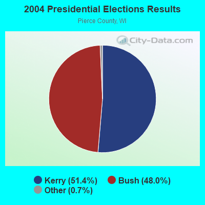
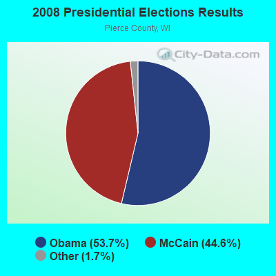
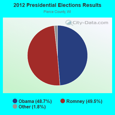
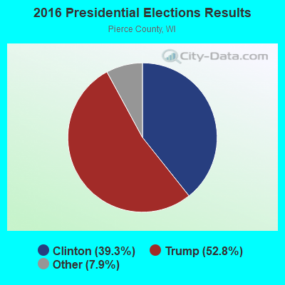
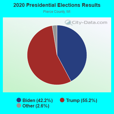
Graphs represent county-level data. Detailed 2008 Election Results
Religion statistics for Trimbelle, WI (based on Pierce County data)
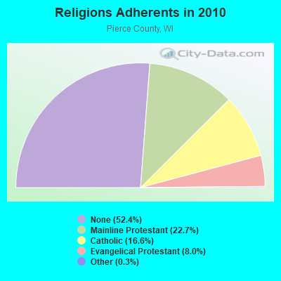
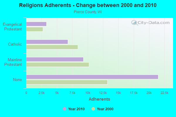
| Religion | Adherents | Congregations |
|---|---|---|
| Mainline Protestant | 9,316 | 29 |
| Catholic | 6,790 | 6 |
| Evangelical Protestant | 3,275 | 20 |
| Other | 137 | 2 |
| None | 21,501 | - |
Food Environment Statistics:
| Pierce County: | 1.51 / 10,000 pop. |
| Wisconsin: | 1.86 / 10,000 pop. |
| Here: | 3.77 / 10,000 pop. |
| Wisconsin: | 4.12 / 10,000 pop. |
| Pierce County: | 7.29 / 10,000 pop. |
| Wisconsin: | 8.64 / 10,000 pop. |
| Pierce County: | 6.4% |
| Wisconsin: | 7.6% |
| This county: | 26.7% |
| Wisconsin: | 27.5% |
| This county: | 10.4% |
| State: | 13.0% |
Strongest AM radio stations in Trimbelle:
- WCTS (1030 AM; 50 kW; MAPLEWOOD, MN; Owner: CNTL. BAPT. THEO/AL SEMI MINNEAPOLIS)
- WDGY (630 AM; 8 kW; HUDSON, WI; Owner: 630 RADIO, INCORPORATED)
- KTIS (900 AM; 25 kW; MINNEAPOLIS, MN; Owner: NORTHWESTERN COLLEGE)
- KSTP (1500 AM; 50 kW; ST. PAUL, MN; Owner: KSTP-AM, LLC (DELAWARE))
- KFAN (1130 AM; 50 kW; MINNEAPOLIS, MN; Owner: AMFM RADIO LICENSES, L.L.C.)
- WCCO (830 AM; 50 kW; MINNEAPOLIS, MN; Owner: INFINITY MEDIA CORPORATION)
- WMEQ (880 AM; 10 kW; MENOMONIE, WI; Owner: CAPSTAR TX LIMITED PARTNERSHIP)
- WMGT (1220 AM; 5 kW; STILLWATER, MN; Owner: ENDURANCE BROADCASTING, LLC)
- WIXK (1590 AM; daytime; 5 kW; NEW RICHMOND, WI; Owner: WIXK-AM, LLC)
- WMIN (740 AM; daytime; 1 kW; HUDSON, WI; Owner: WRPX, INC.)
- WEVR (1550 AM; 1 kW; RIVER FALLS, WI; Owner: HANTEN BROADCASTING CO. INC.)
- KUOM (770 AM; daytime; 5 kW; MINNEAPOLIS, MN)
- WMNN (1330 AM; 10 kW; MINNEAPOLIS, MN; Owner: MINNESOTA PUBLIC RADIO.)
Strongest FM radio stations in Trimbelle:
- WXPT (104.1 FM; ST. LOUIS PARK, MN; Owner: THE AUDIO HOUSE, INC.)
- WEVR-FM (106.3 FM; RIVER FALLS, WI; Owner: HANTEN BROADCASTING COMPANY, INC.)
- KNOW-FM (91.1 FM; MINNEAPOLIS-ST. PAUL, MN; Owner: MINNESOTA PUBLIC RADIO)
- WLTE (102.9 FM; MINNEAPOLIS, MN; Owner: INFINITY MEDIA CORPORATION)
- KSTP-FM (94.5 FM; ST. PAUL, MN; Owner: KSTP-FM, LLC, A DELAWARE LLC)
- WCAL (89.3 FM; NORTHFIELD, MN; Owner: ST. OLAF COLLEGE)
- KEEY-FM (102.1 FM; ST. PAUL, MN; Owner: AMFM RADIO LICENSES, L.L.C.)
- KTIS-FM (98.5 FM; MINNEAPOLIS, MN; Owner: NORTHWESTERN COLLEGE)
- KDWB-FM (101.3 FM; RICHFIELD, MN; Owner: AMFM RADIO LICENSES, L.L.C.)
- KQRS-FM (92.5 FM; GOLDEN VALLEY, MN; Owner: KQRS, Inc.)
- KSJN (99.5 FM; MINNEAPOLIS, MN; Owner: MINNESOTA PUBLIC RADIO)
- KXXR (93.7 FM; MINNEAPOLIS, MN; Owner: KQRS, INC.)
- WHWC (88.3 FM; MENOMONIE, WI; Owner: STATE OF WISCONSIN - EDUCATIONAL COMMUNICATIONS BOARD)
- KWNG (105.9 FM; RED WING, MN; Owner: SORENSON BROADCASTING CORPORATION)
- W211AY (90.1 FM; MENOMONIE, WI; Owner: CALVARY CHAPEL OF TWIN FALLS, INC.)
- WVSS (90.7 FM; MENOMONIE, WI; Owner: BD. OF REGENTS, UNIVERSITY OF WISCONSIN SYSTEM)
- KTCZ-FM (97.1 FM; MINNEAPOLIS, MN; Owner: AMFM RADIO LICENSES, L.L.C.)
- WGVX (105.1 FM; LAKEVILLE, MN; Owner: KQRS, INC.)
- K297AF (107.3 FM; RED WING, MN; Owner: KRCH OF MINNESOTA, INC.)
- KLCH (94.9 FM; LAKE CITY, MN; Owner: WAITT RADIO, INC.)
TV broadcast stations around Trimbelle:
- KMSP-TV (Channel 9; MINNEAPOLIS, MN; Owner: FOX TELEVISION STATIONS, INC.)
- KARE (Channel 11; MINNEAPOLIS, MN; Owner: MULTIMEDIA HOLDINGS CORPORATION)
- KTCA-TV (Channel 2; ST. PAUL, MN; Owner: TWIN CITIES PUBLIC TELEVISION, INC.)
- KSTP-TV (Channel 5; ST. PAUL, MN; Owner: HUBBARD BROADCASTING, INC.)
- WCCO-TV (Channel 4; MINNEAPOLIS, MN; Owner: CBS BROADCASTING INC.)
- KTCI-TV (Channel 17; ST. PAUL, MN; Owner: TWIN CITIES PUBLIC TELEVISION, INC.)
- KSTC-TV (Channel 45; MINNEAPOLIS, MN; Owner: HUBBARD BROADCASTING, INC.)
- KMWB (Channel 23; MINNEAPOLIS, MN; Owner: KLGT LICENSEE, LLC)
- WFTC (Channel 29; MINNEAPOLIS, MN; Owner: FOX TELEVISION STATIONS, INC.)
- W55AP (Channel 55; RIVER FALLS, WI; Owner: STATE OF WISCONSIN - EDUCATIONAL COMMUNICATIONS BOARD)
- WHWC-TV (Channel 28; MENOMONIE, WI; Owner: STATE OF WISCONSIN - EDUCATIONAL COMMUNICATIONS BOARD)
- K07UI (Channel 7; MINNEAPOLIS, ETC., MN; Owner: WORD OF GOD FELLOWSHIP, INC.)
- K58BS (Channel 58; MINNEAPOLIS, MN; Owner: TRINITY BROADCASTING NETWORK)
- K67HG (Channel 67; MINNEAPOLIS, MN; Owner: VENTANA TELEVISION, INC.)
- K14KH (Channel 14; MINNEAPOLIS, MN; Owner: THREE ANGELS BROADCASTING NETWORK)
- K19ER (Channel 19; ST. PAUL, MN; Owner: CATHOLIC VIEWS BROADCASTS, INC.)
- W62BD (Channel 62; MINNEAPOLIS, MN; Owner: WORD OF GOD FELLOWSHIP, INC.)
- National Bridge Inventory (NBI) Statistics
- 31Number of bridges
- 174ft / 52.5mTotal length
- $592,000Total costs
- 32,074Total average daily traffic
- 2,488Total average daily truck traffic
- 38,328Total future (year 2039) average daily traffic
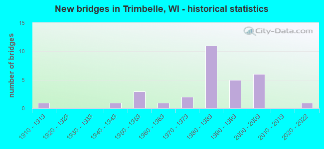
- New bridges - historical statistics
- 11910-1919
- 11940-1949
- 31950-1959
- 11960-1969
- 21970-1979
- 111980-1989
- 51990-1999
- 62000-2009
- 12020-2022
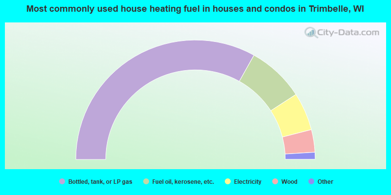
- 66.2%Bottled, tank, or LP gas
- 15.4%Fuel oil, kerosene, etc.
- 10.3%Electricity
- 6.1%Wood
- 1.5%Utility gas
- 0.4%No fuel used
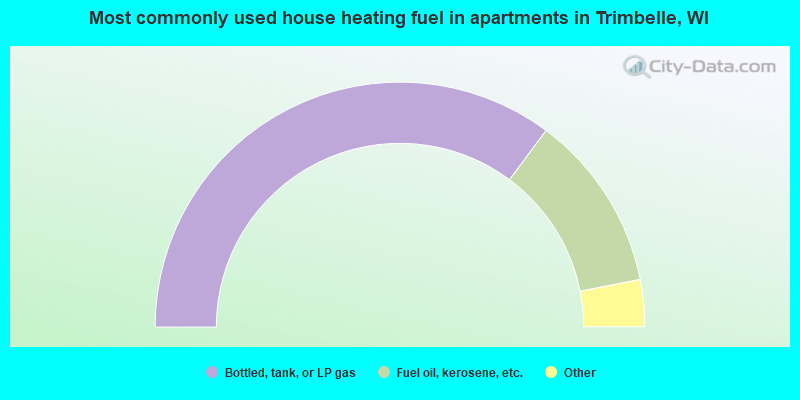
- 70.3%Bottled, tank, or LP gas
- 23.4%Fuel oil, kerosene, etc.
- 3.1%Electricity
- 3.1%Wood
Trimbelle compared to Wisconsin state average:
- Unemployed percentage below state average.
- Black race population percentage significantly below state average.
- Hispanic race population percentage significantly below state average.
- Foreign-born population percentage significantly below state average.
- Renting percentage significantly below state average.
- Length of stay since moving in significantly above state average.
- Number of rooms per house significantly below state average.
- House age significantly below state average.
- Percentage of population with a bachelor's degree or higher below state average.