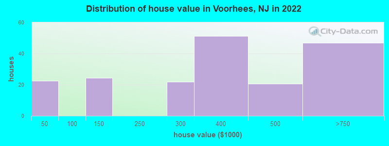
Estimated median house or condo value in 2022: $497,200
Voorhees:
$497,200
NJ:
$428,900
Mean prices in 2022:all housing units: $367,178; detached houses: $376,014
Median gross rent in 2022: $1,453.
March 2022 cost of living index in Voorhees: 118.8 (more than average, U.S. average is 100)Percentage of residents living in poverty in 2022: 17.5%
(4.5% for Black residents, 50.0% for Hispanic or Latino residents, 64.3% for two or more races residents)
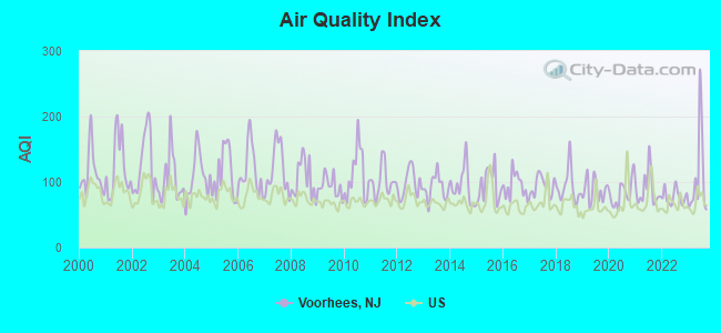
Air Quality Index (AQI) level in 2023 was 107. This is significantly worse than average.
City:
107
U.S.:
73
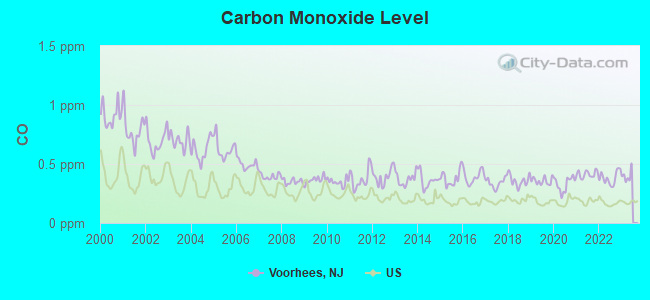
Carbon Monoxide (CO) [ppm] level in 2022 was 0.381. This is significantly worse than average.Closest monitor was 7.0 miles away from the city center.
City:
0.381
U.S.:
0.251
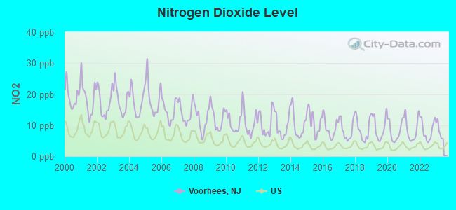
Nitrogen Dioxide (NO2) [ppb] level in 2022 was 8.40. This is significantly worse than average.Closest monitor was 2.3 miles away from the city center.
City:
8.40
U.S.:
5.11
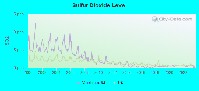
Sulfur Dioxide (SO2) [ppb] level in 2022 was 0.547. This is significantly better than average.Closest monitor was 2.3 miles away from the city center.
City:
0.547
U.S.:
1.515
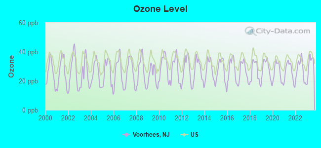
Ozone [ppb] level in 2023 was 31.1. This is about average.Closest monitor was 3.1 miles away from the city center.
City:
31.1
U.S.:
33.3
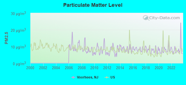
Particulate Matter (PM2.5) [µg/m3] level in 2023 was 9.22. This is about average.Closest monitor was 3.1 miles away from the city center.
City:
9.22
U.S.:
8.11
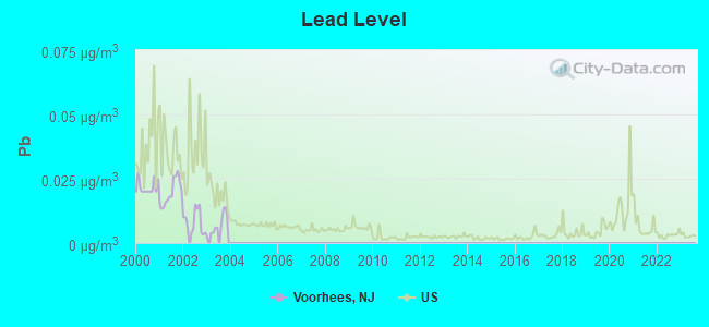
Lead (Pb) [µg/m3] level in 2003 was 0.00543. This is significantly better than average.Closest monitor was 3.4 miles away from the city center.
City:
0.00543
U.S.:
0.00931
Tornado activity:
Voorhees-area historical tornado activity is near New Jersey state average. It is 27% smaller than the overall U.S. average.
On 10/18/1990, a category F3 (max. wind speeds 158-206 mph) tornado 15.1 miles away from the Voorhees place center injured 8 peopleand causedbetween $500,000 and $5,000,000 in damages.
On 5/28/1973, a category F3 tornado 22.1 miles away from the place center causedbetween $50,000 and $500,000 in damages.
Earthquake activity:
Voorhees-area historical earthquake activity is significantly above New Jersey state average. It is 68% smaller than the overall U.S. average.
On 8/23/2011 at 17:51:04, a magnitude 5.8 (5.8 MW, Depth: 3.7 mi, Class: Moderate, Intensity: VI - VII) earthquake occurred 256.6 miles away from the city center On 1/16/1994 at 01:49:16, a magnitude 4.6 (4.6 MB, 4.6 LG, Depth: 3.1 mi, Class: Light, Intensity: IV - V) earthquake occurred 82.5 miles away from the city center On 10/7/1983 at 10:18:46, a magnitude 5.3 (5.1 MB, 5.3 LG, 5.1 ML) earthquake occurred 240.3 miles away from Voorhees center On 4/20/2002 at 10:50:47, a magnitude 5.3 (5.3 ML, Depth: 3.0 mi) earthquake occurred 281.7 miles away from Voorhees center On 1/16/1994 at 00:42:43, a magnitude 4.2 (4.2 MB, 4.0 LG, Depth: 3.1 mi) earthquake occurred 80.9 miles away from Voorhees center On 4/20/2002 at 10:50:47, a magnitude 5.2 (5.2 MB, 4.2 MS, 5.2 MW, 5.0 MW) earthquake occurred 279.8 miles away from the city center Magnitude types: regional Lg-wave magnitude (LG), body-wave magnitude (MB), local magnitude (ML), surface-wave magnitude (MS), moment magnitude (MW)
Natural disasters:
The number of natural disasters in Somerset County (27) is a lot greater than the US average (15). Major Disasters (Presidential) Declared: 17 Emergencies Declared: 9
Causes of natural disasters: Floods: 7, Hurricanes: 7, Storms: 6, Heavy Rains: 4, Snowstorms: 4, Winter Storms: 3, Blizzards: 2, Water Shortages: 2, Tornado: 1, Wind: 1, Other: 3 (Note: some incidents may be assigned to more than one category).
Hospitals and medical centers in Voorhees:
SUMMIT SURGICAL CENTER LLC (110 CARNIE BOULEVARD)
KRESSON VIEW CENTER (2601 EVESHAM ROAD)
LIONS GATE (1100 LAUREL OAK ROAD)
MANORCARE HEALTH SERVICES VOORHEES (1086 DUMONT CIRCLE)
VOORHEES CARE AND REHABILITATION CENTER, THE (1302 LAUREL OAK ROAD)
VOORHEES CENTER (3001 EVESHAM ROAD)
VOORHEES PEDIATRIC FACILITY (1304 LAUREL OAK ROAD)
KENNEDY DIALYSIS CENTER VOORHEES (201 LAUREL OAK ROAD)
KENNEDY UNIVERSITY HOSPITAL, INC HOME HEALTH CARE (1099 WHITE HORSE ROAD)
3 miles: NEW BRUNSWICK (FRENCH & ALBANY STS.) . Services: ticket office, fully wheelchair accessible, enclosed waiting area, public restrooms, public payphones, snack bar, ATM, free short-term parking, free long-term parking, call for car rental service, taxi stand, public transit connection.
11 miles: METROPARK (ISELIN, 100 MIDDLESEX-ESSEX TPK.) . Services: ticket office, fully wheelchair accessible, enclosed waiting area, public restrooms, public payphones, paid short-term parking, call for car rental service, taxi stand, public transit connection.
14 miles: PRINCETON JUNCTION (WALLACE RD.) . Services: ticket office, fully wheelchair accessible, enclosed waiting area, public restrooms, snack bar, paid short-term parking, paid long-term parking, call for car rental service, taxi stand, public transit connection.
Colleges/Universities in Voorhees:
Harris School of Business-Voorhees Campus (Full-time enrollment: 651; Location: 401 White Horse Rd.; Private, for-profit; Website: www.harrisschool.edu)
Rizzieri Aveda School for Beauty and Wellness (Full-time enrollment: 319; Location: 8200 Town Center Blvd; Private, for-profit; Website: www.rizzierischools.com)
Rizzieri Institute (Full-time enrollment: 11; Location: 8102 Town Center Boulevard; Private, for-profit; Website: www.rizzierischoolofmassage.com)
Colleges/universities with over 2000 students nearest to Voorhees:
Birthplace of: Dominick Mejia - College basketball player (Drexel Dragons), Will Carney - College football player (Bucknell Bison).
Somerset County has a predicted average indoor radon screening level greater than 4 pCi/L (pico curies per liter) - Highest Potential
Drinking water stations with addresses in Voorhees and their reported violations in the past:
NJ AMERICAN WATER - OCEAN CITY (Population served: 127,000, Groundwater):
Past monitoring violations:
Monitoring and Reporting (DBP) - Between OCT-2010 and DEC-2010, Contaminant: Total Haloacetic Acids (HAA5). Follow-up actions: St Compliance achieved (JAN-14-2011), St Public Notif requested (MAR-17-2011), St Formal NOV issued (MAR-17-2011)
Monitoring and Reporting (DBP) - Between OCT-2010 and DEC-2010, Contaminant: TTHM. Follow-up actions: St Compliance achieved (JAN-14-2011), St Public Notif requested (MAR-17-2011), St Formal NOV issued (MAR-17-2011)
NJ AMERICAN WATER - ATLANTIC COUNTY (Population served: 120,000, Purch surface water):
Past monitoring violations:
Monitoring and Reporting (DBP) - Between JAN-2005 and MAR-2005, Contaminant: TTHM. Follow-up actions: St Compliance achieved (JUN-10-2005), St Public Notif requested (DEC-02-2009), St Formal NOV issued (DEC-02-2009)
Monitoring and Reporting (DBP) - Between JAN-2005 and MAR-2005, Contaminant: Total Haloacetic Acids (HAA5). Follow-up actions: St Compliance achieved (JUN-10-2005), St Public Notif requested (DEC-02-2009), St Formal NOV issued (DEC-02-2009)
One minor monitoring violation
NJ AMERICAN WATER - LOGAN (Population served: 6,650, Purch surface water):
Past monitoring violations:
Monitoring and Reporting (DBP) - Between JAN-2009 and DEC-2009, Contaminant: TTHM. Follow-up actions: St Compliance achieved (MAY-24-2010), St Public Notif requested (JUL-14-2010), St Formal NOV issued (JUL-14-2010)
Monitoring and Reporting (DBP) - Between JAN-2009 and DEC-2009, Contaminant: Total Haloacetic Acids (HAA5). Follow-up actions: St Compliance achieved (MAY-24-2010), St Public Notif requested (JUL-14-2010), St Formal NOV issued (JUL-14-2010)
One routine major monitoring violation
NJ AMERICAN WATER - CAPE MAY COURT HOUSE (Population served: 4,142, Groundwater):
Past monitoring violations:
Follow-up Or Routine LCR Tap M/R - In OCT-01-2005, Contaminant: Lead and Copper Rule. Follow-up actions: St Compliance achieved (JUL-12-2009)
SUNOCO #2315 (Address: SUITE 10 , Population served: 255, Groundwater):
Past health violations:
MCL, Monthly (TCR) - Between APR-2009 and JUN-2009, Contaminant: Coliform. Follow-up actions: St Public Notif received (APR-30-2009), St Public Notif requested (MAY-19-2009), St Formal NOV issued (MAY-19-2009), St Compliance achieved (MAY-21-2009)
BUENA FAMILY MANOR MOBILE H P (Population served: 65, Groundwater):
Past monitoring violations:
5 regular monitoring violations
Drinking water stations with addresses in Voorhees that have no violations reported:
NJ AMERICAN WATER - WESTERN (Population served: 253,045,Primary Water Source Type: Surface water)
NJ AMERICAN WATER - WESTERN (Population served: 253,045,Primary Water Source Type: Surface water)
NJ AMERICAN WATER - PENNS GROVE (Population served: 14,406,Primary Water Source Type: Purch surface water)
NJ AMERICAN WATER - HARRISON (Population served: 9,450,Primary Water Source Type: Purch surface water)
NJ AMERICAN WATER - BRIDGEPORT (Population served: 1,085,Primary Water Source Type: Purch surface water)
NJ AMERICAN WATER - SUNBURY (Population served: 888,Primary Water Source Type: Groundwater)
NJ AMERICAN WATER - STRATHMERE (Population served: 755,Primary Water Source Type: Groundwater)
SUNOCO A-PLUS (Address: SUITE 10 , Population served: 53,Primary Water Source Type: Groundwater)
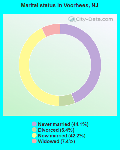
Average household size:
This place:
3.2 people
New Jersey:
2.7 people
Percentage of family households:
This place:
82.4%
Whole state:
69.3%
Percentage of households with unmarried partners:
This place:
7.0%
Whole state:
5.9%
Likely homosexual households (counted as self-reported same-sex unmarried-partner households)
Lesbian couples: 0.7% of all households
Gay men: 0.0% of all households
Banks with most branches in Voorhees (2011 data):
Citizens Bank of Pennsylvania: Coopers Plaza Branch, Voorhees Branch, Voorhees Acme Branch. Info updated 2010/09/24: Bank assets: $32,316.9 mil, Deposits: $25,297.1 mil, headquarters in Philadelphia, PA, positive income, 396 total offices, Holding Company: Uk Financial Investments Limited
Republic Bank: Voorhees Branch at 342 South Burntmill Road, branch established on 2006/08/01. Info updated 2010/09/28: Bank assets: $1,044.4 mil, Deposits: $954.7 mil, headquarters in Philadelphia, PA, negative income in the last year, Commercial Lending Specialization, 14 total offices, Holding Company: Republic First Bancorp, Inc.
Fulton Bank of New Jersey: Voorhees Branch at 6 Berlin Road, branch established on 2006/03/13. Info updated 2012/02/08: Bank assets: $3,408.9 mil, Deposits: $2,816.1 mil, headquarters in Mount Laurel, NJ, negative income in the last year, Commercial Lending Specialization, 74 total offices, Holding Company: Fulton Financial Corporation
Cornerstone Bank: Voorhees Branch at 133 Route 73, branch established on 2006/10/25. Info updated 2010/10/06: Bank assets: $383.7 mil, Deposits: $330.5 mil, headquarters in Moorestown, NJ, negative income in the last year, Commercial Lending Specialization, 8 total offices, Holding Company: Cornerstone Financial Corporation
Roma Bank: Voorhees Branch at 1006 Kresson Road, branch established on 2005/11/01. Info updated 2011/07/21: Bank assets: $1,735.5 mil, Deposits: $1,469.2 mil, headquarters in Robbinsville, NJ, positive income, Mortgage Lending Specialization, 25 total offices
PNC Bank, National Association: Voorhees Branch at 11 Haddonfield Berlin Road, branch established on 1960/09/06. Info updated 2012/03/20: Bank assets: $263,309.6 mil, Deposits: $197,343.0 mil, headquarters in Wilmington, DE, positive income, Commercial Lending Specialization, 3085 total offices, Holding Company: Pnc Financial Services Group, Inc., The
TD Bank, National Association: Voorhees Branch at Route 73 And Kresson Road, branch established on 1991/05/04. Info updated 2010/10/04: Bank assets: $188,912.6 mil, Deposits: $153,149.8 mil, headquarters in Wilmington, DE, positive income, 1314 total offices, Holding Company: Toronto-Dominion Bank, The
Columbia Bank: Voorhees Branch at 900 White Horse Road, branch established on 1978/06/03. Info updated 2011/07/21: Bank assets: $4,478.2 mil, Deposits: $2,795.4 mil, headquarters in Fair Lawn, NJ, positive income, Commercial Lending Specialization, 44 total offices
Bank of America, National Association: Voorhees Township Branch at 703 Haddonfield-Berlin Roads, branch established on 1983/04/04. Info updated 2009/11/18: Bank assets: $1,451,969.3 mil, Deposits: $1,077,176.8 mil, headquarters in Charlotte, NC, positive income, 5782 total offices, Holding Company: Bank Of America Corporation
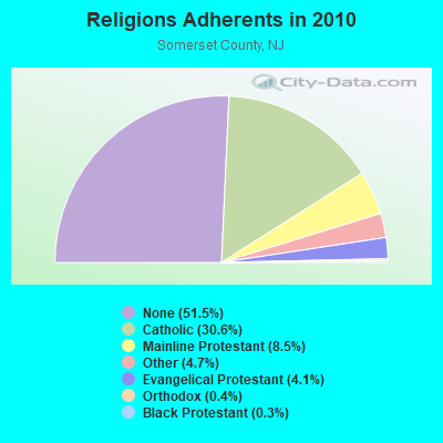
Religion statistics for Voorhees, NJ (based on Somerset County data)
Religion
Adherents
Congregations
Catholic
98,951
29
Mainline Protestant
27,472
68
Other
15,078
33
Evangelical Protestant
13,158
53
Orthodox
1,200
6
Black Protestant
1,076
7
None
166,509
-
Source: Clifford Grammich, Kirk Hadaway, Richard Houseal, Dale E.Jones, Alexei Krindatch, Richie Stanley and Richard H.Taylor. 2012. 2010 U.S.Religion Census: Religious Congregations & Membership Study. Association of Statisticians of American Religious Bodies. Jones, Dale E., et al. 2002. Congregations and Membership in the United States 2000. Nashville, TN: Glenmary Research Center. Graphs represent county-level data
Food Environment Statistics:
Number of grocery stores: 69
This county:
2.14 / 10,000 pop.
New Jersey:
2.90 / 10,000 pop.
Number of supercenters and club stores: 3
Somerset County:
0.09 / 10,000 pop.
State:
0.06 / 10,000 pop.
Number of convenience stores (no gas): 53
This county:
1.65 / 10,000 pop.
New Jersey:
1.76 / 10,000 pop.
Number of convenience stores (with gas): 18
Here:
0.56 / 10,000 pop.
New Jersey:
0.81 / 10,000 pop.
Number of full-service restaurants: 256
Here:
7.96 / 10,000 pop.
State:
7.15 / 10,000 pop.
Adult diabetes rate:
Somerset County:
6.7%
State:
8.3%
Adult obesity rate:
Somerset County:
20.4%
State:
23.3%
Low-income preschool obesity rate:
Here:
24.0%
New Jersey:
18.0%
Businesses in Voorhees, NJ
Name
Count
Name
Count
AT&T
1
Macy's
1
Applebee's
1
Marshalls
1
Baja Fresh Mexican Grill
1
MasterBrand Cabinets
3
Bally Total Fitness
1
McDonald's
1
Bath & Body Works
1
Motherhood Maternity
2
Blockbuster
1
Nike
3
CVS
1
Office Depot
1
Chick-Fil-A
1
Olive Garden
1
Cricket Wireless
1
Panera Bread
1
DHL
1
Payless
1
Domino's Pizza
1
Quiznos
1
Dunkin Donuts
2
RadioShack
1
FedEx
7
Raymour & Flanigan
1
Finish Line
1
Rite Aid
3
GNC
2
Sears
1
GameStop
3
Subway
6
H&R Block
1
T-Mobile
2
Hilton
1
Taco Bell
1
Hot Topic
1
Target
1
Jones New York
2
True Value
1
KFC
1
UPS
10
Kohl's
1
Verizon Wireless
1
La-Z-Boy
2
Victoria's Secret
1
LensCrafters
1
Wendy's
2
Lowe's
1
Wingate
1
Strongest AM radio stations in Voorhees:
WMCA (570 AM; 50 kW; NEW YORK, NY; Owner: SALEM MEDIA OF NEW YORK, LLC)
WOR (710 AM; 50 kW; NEW YORK, NY; Owner: BUCKLEY BROADCASTING CORPORATION)
WCTC (1450 AM; 1 kW; NEW BRUNSWICK, NJ; Owner: THE SENTINEL PUBLISHING CO.)
WINS (1010 AM; 50 kW; NEW YORK, NY; Owner: INFINITY BROADCASTING OPERATIONS, INC.)
WABC (770 AM; 50 kW; NEW YORK, NY; Owner: WABC-AM RADIO, INC.)
WEPN (1050 AM; 50 kW; NEW YORK, NY; Owner: NEW YORK AM RADIO, LLC)
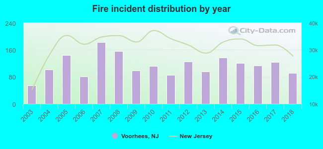
2003 - 2018 National Fire Incident Reporting System (NFIRS) incidents
According to the data from the years 2003 - 2018 the average number of fires per year is 114. The highest number of fires - 182 took place in 2007, and the least - 54 in 2003. The data has a rising trend.
When looking into fire subcategories, the most incidents belonged to: Structure Fires (63.3%), and Outside Fires (24.3%).
Fire incident types reported to NFIRS in Voorhees, NJ


 Recent articles from our blog. Our writers, many of them Ph.D. graduates or candidates, create easy-to-read articles on a wide variety of topics.
 (6.8 miles
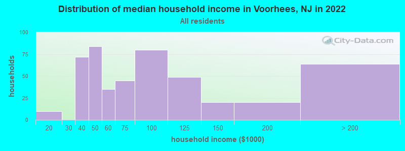
 According to the data from the years 2003 - 2018 the average number of fires per year is 114. The highest number of fires - 182 took place in 2007, and the least - 54 in 2003. The data has a rising trend.
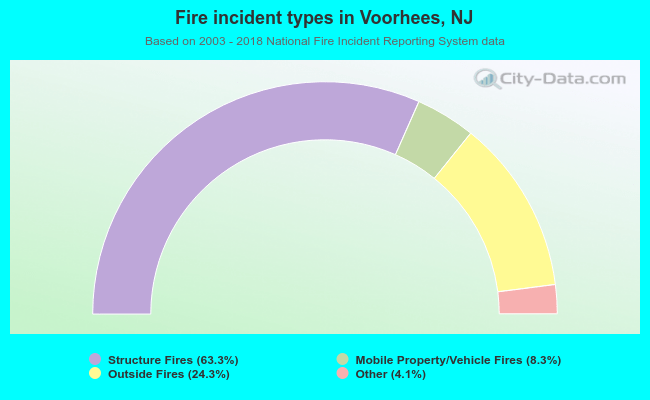 When looking into fire subcategories, the most incidents belonged to: Structure Fires (63.3%), and Outside Fires (24.3%).