Warner, Wisconsin
Submit your own pictures of this town and show them to the world
- OSM Map
- Google Map
- MSN Map
Population change since 2000: +6.7%
 |
| Males: 331 | |
| Females: 338 |
| Median resident age: | 33.1 years |
| Wisconsin median age: | 42.6 years |
Zip codes: 54437.
| Warner: | $66,739 |
| WI: | $70,996 |
Estimated per capita income in 2022: $26,380 (it was $13,443 in 2000)
Warner town income, earnings, and wages data
Estimated median house or condo value in 2022: $185,590 (it was $78,500 in 2000)
| Warner: | $185,590 |
| WI: | $252,800 |
Mean prices in 2022: all housing units: $219,245; detached houses: $223,709; townhouses or other attached units: $302,988; in 2-unit structures: $128,535; in 3-to-4-unit structures: $94,848; in 5-or-more-unit structures: $472,971; mobile homes: $106,493; occupied boats, rvs, vans, etc.: over $1,000,000
Detailed information about poverty and poor residents in Warner, WI


- 66599.4%White alone
- 40.6%Hispanic

Races in Warner detailed stats: ancestries, foreign born residents, place of birth
 Recent articles from our blog. Our writers, many of them Ph.D. graduates or candidates, create easy-to-read articles on a wide variety of topics.
Ancestries: German (50.2%), Norwegian (9.3%), English (7.0%), French (5.7%), Irish (5.4%), Polish (5.4%).
Current Local Time: CST time zone
Land area: 34.9 square miles.
Population density: 19 people per square mile (very low).
5 residents are foreign born
| This town: | 0.8% |
| Wisconsin: | 3.6% |
| Warner town: | 1.3% ($1,050) |
| Wisconsin: | 2.0% ($2,245) |
Nearest city with pop. 50,000+: Eau Claire, WI  (43.5 miles , pop. 61,704).
Nearest city with pop. 200,000+: St. Paul, MN (123.3 miles , pop. 287,151).
Nearest city with pop. 1,000,000+: Chicago, IL (253.0 miles , pop. 2,896,016).
Nearest cities:
), ), ), ), ), Latitude: 44.82 N, Longitude: 90.61 W
Area code commonly used in this area: 715

Single-family new house construction building permits:
- 2022: 2 buildings, average cost: $273,300
- 2019: 2 buildings, average cost: $270,700
- 2016: 1 building, cost: $100,000


| Here: | 2.8% |
| Wisconsin: | 2.7% |

- Agriculture, forestry, fishing & hunting (29.2%)
- Health care (11.7%)
- Food (10.2%)
- Wood products (8.0%)
- Educational services (4.7%)
- Public administration (3.3%)
- Construction (2.9%)

- Agriculture, forestry, fishing & hunting (37.6%)
- Food (14.0%)
- Wood products (9.6%)
- Utilities (4.5%)
- Construction (3.8%)
- Building material & garden equipment & supplies dealers (3.8%)
- Furniture & related product manufacturing (3.8%)

- Health care (27.4%)
- Agriculture, forestry, fishing & hunting (17.9%)
- Educational services (10.3%)
- Wood products (6.0%)
- Public administration (6.0%)
- Accommodation & food services (6.0%)
- Food (5.1%)

- Farmers and farm managers (19.3%)
- Other production occupations, including supervisors (10.6%)
- Agricultural workers, including supervisors (9.1%)
- Other office and administrative support workers, including supervisors (5.1%)
- Driver/sales workers and truck drivers (4.0%)
- Metal workers and plastic workers (2.9%)
- Retail sales workers, except cashiers (2.6%)

- Farmers and farm managers (21.7%)
- Other production occupations, including supervisors (14.6%)
- Agricultural workers, including supervisors (14.6%)
- Driver/sales workers and truck drivers (7.0%)
- Metal workers and plastic workers (5.1%)
- Laborers and material movers, hand (4.5%)
- Electrical equipment mechanics and other installation, maintenance, and repair workers, including supervisors (4.5%)

- Farmers and farm managers (16.2%)
- Other office and administrative support workers, including supervisors (12.0%)
- Waiters and waitresses (6.0%)
- Other healthcare support occupations (5.1%)
- Other production occupations, including supervisors (5.1%)
- Health technologists and technicians (4.3%)
- Nursing, psychiatric, and home health aides (4.3%)
Average climate in Warner, Wisconsin
Based on data reported by over 4,000 weather stations


Tornado activity:
Warner-area historical tornado activity is near Wisconsin state average. It is 5% greater than the overall U.S. average.
On 6/4/1958, a category F4 (max. wind speeds 207-260 mph) tornado 26.9 miles away from the Warner town center killed 4 people and injured 3 people and caused between $500,000 and $5,000,000 in damages.
On 6/4/1958, a category F4 tornado 34.0 miles away from the town center killed 3 people and injured 50 people and caused between $50,000 and $500,000 in damages.
Earthquake activity:
Warner-area historical earthquake activity is significantly above Wisconsin state average. It is 74% smaller than the overall U.S. average.On 7/9/1975 at 14:54:15, a magnitude 4.6 (4.6 MB, Class: Light, Intensity: IV - V) earthquake occurred 271.1 miles away from the city center
On 6/28/2004 at 06:10:52, a magnitude 4.2 (4.2 MW, Depth: 6.2 mi) earthquake occurred 247.6 miles away from the city center
On 2/10/2010 at 09:59:35, a magnitude 3.8 (3.8 MW, Depth: 6.2 mi, Class: Light, Intensity: II - III) earthquake occurred 223.6 miles away from Warner center
On 6/5/1993 at 01:24:53, a magnitude 4.1 (4.1 LG, Depth: 6.2 mi) earthquake occurred 283.2 miles away from Warner center
On 5/2/2015 at 16:23:07, a magnitude 4.2 (4.2 MW, Depth: 2.8 mi) earthquake occurred 315.0 miles away from the city center
On 9/2/1999 at 16:17:29, a magnitude 3.5 (3.5 LG, Depth: 3.1 mi) earthquake occurred 222.1 miles away from the city center
Magnitude types: regional Lg-wave magnitude (LG), body-wave magnitude (MB), moment magnitude (MW)
Natural disasters:
The number of natural disasters in Clark County (14) is near the US average (15).Major Disasters (Presidential) Declared: 11
Emergencies Declared: 2
Causes of natural disasters: Floods: 11, Storms: 10, Tornadoes: 4, Winds: 3, Drought: 1, Heavy Rain: 1, Hurricane: 1, Mudslide: 1, Other: 1 (Note: some incidents may be assigned to more than one category).
Colleges/universities with over 2000 students nearest to Warner:
- University of Wisconsin-Eau Claire (about 44 miles; Eau Claire, WI; Full-time enrollment: 10,143)
- Chippewa Valley Technical College (about 45 miles; Eau Claire, WI; FT enrollment: 4,038)
- Northcentral Technical College (about 49 miles; Wausau, WI; FT enrollment: 3,356)
- Mid-State Technical College (about 51 miles; Wisconsin Rapids, WI; FT enrollment: 2,128)
- University of Wisconsin-Stevens Point (about 55 miles; Stevens Point, WI; FT enrollment: 9,089)
- University of Wisconsin-Stout (about 66 miles; Menomonie, WI; FT enrollment: 8,120)
- Winona State University (about 74 miles; Winona, MN; FT enrollment: 8,397)
Points of interest:
Church in Warner: Immanuel Church (A). Display/hide its location on the map
Cemeteries: Immanuel Lutheran Cemetery (1), Forest Hill Cemetery (2). Display/hide their locations on the map
Rivers and creeks: Behringer Creek (A), Gile Creek (B), Popple River (C). Display/hide their locations on the map
Park in Warner: Greenwood Park (1). Display/hide its location on the map
| This town: | 3.1 people |
| Wisconsin: | 2.4 people |
| This town: | 83.6% |
| Whole state: | 64.4% |
| This town: | 3.7% |
| Whole state: | 7.3% |
Likely homosexual households (counted as self-reported same-sex unmarried-partner households)
- Lesbian couples: 0.5% of all households
- Gay men: 0.0% of all households
| This town: | 7.9% |
| Whole state: | 8.7% |
| This town: | 2.6% |
| Whole state: | 3.7% |
11 people in nursing homes in 2000
For population 15 years and over in Warner:

- Never married: 19.9%
- Now married: 65.8%
- Separated: 0.4%
- Widowed: 2.0%
- Divorced: 11.9%
For population 25 years and over in Warner:
- High school or higher: 77.0%
- Bachelor's degree or higher: 9.4%
- Graduate or professional degree: 1.9%
- Unemployed: 3.5%
- Mean travel time to work (commute): 30.3 minutes


| Here: | 11.2 |
| Wisconsin average: | 11.0 |
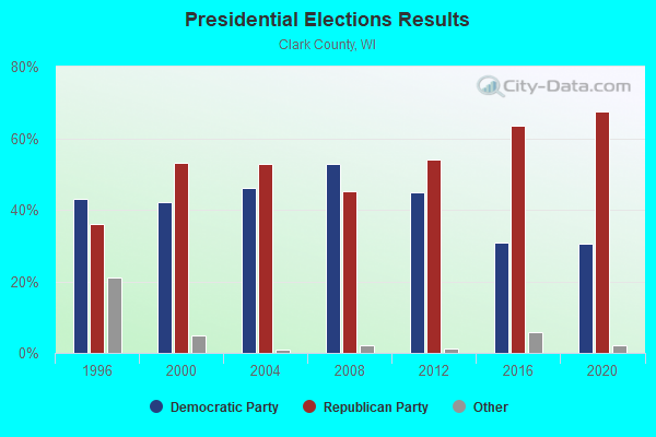
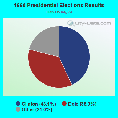
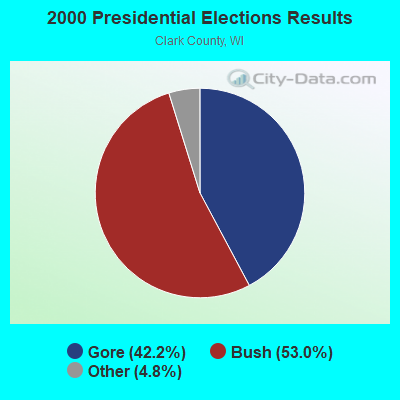
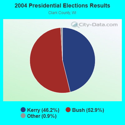
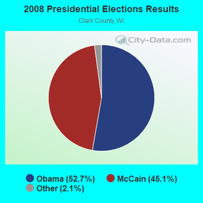
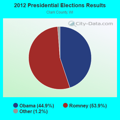
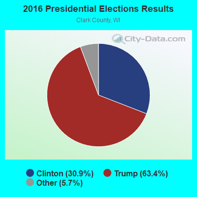
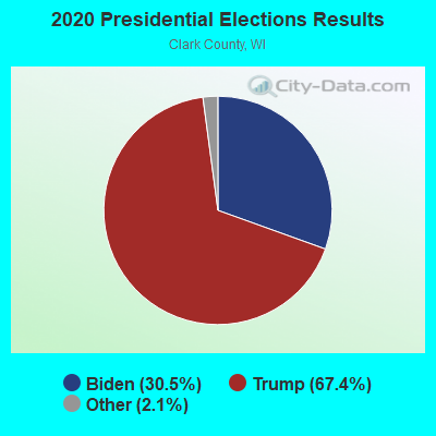
Graphs represent county-level data. Detailed 2008 Election Results
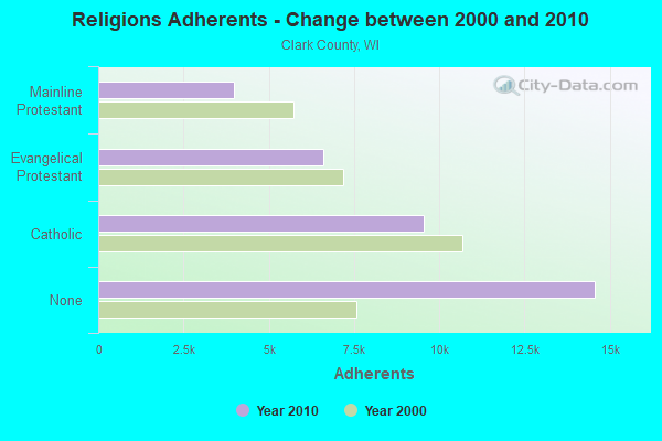
Religion statistics for Warner, WI (based on Clark County data)
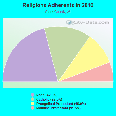
| Religion | Adherents | Congregations |
|---|---|---|
| Catholic | 9,535 | 9 |
| Evangelical Protestant | 6,594 | 41 |
| Mainline Protestant | 3,981 | 25 |
| Other | 7 | 5 |
| Orthodox | - | - |
| None | 14,573 | - |
Food Environment Statistics:
| Clark County: | 2.69 / 10,000 pop. |
| State: | 1.86 / 10,000 pop. |
| This county: | 5.38 / 10,000 pop. |
| Wisconsin: | 4.12 / 10,000 pop. |
| Clark County: | 7.78 / 10,000 pop. |
| State: | 8.64 / 10,000 pop. |
| Clark County: | 7.9% |
| Wisconsin: | 7.6% |
| Clark County: | 28.3% |
| Wisconsin: | 27.5% |
| This county: | 16.2% |
| State: | 13.0% |
Strongest AM radio stations in Warner:
- WSPT (1010 AM; 50 kW; STEVENS POINT, WI)
- WSAU (550 AM; 20 kW; WAUSAU, WI; Owner: WRIG, INC.)
- WCCN (1370 AM; 5 kW; NEILLSVILLE, WI; Owner: CENTRAL WISCONSIN BROADCASTING, INC.)
- WLBL (930 AM; 5 kW; AUBURNDALE, WI; Owner: STATE OF WISCONSIN - EDUCATIONAL COMMUNICATIONS BOARD)
- WEBC (560 AM; 50 kW; DULUTH, MN)
- WCTS (1030 AM; 50 kW; MAPLEWOOD, MN; Owner: CNTL. BAPT. THEO/AL SEMI MINNEAPOLIS)
- WAYY (790 AM; 5 kW; EAU CLAIRE, WI; Owner: MAVERICK MEDIA OF EAU CLAIRE LICENSE LLC)
- WRIG (1390 AM; 10 kW; SCHOFIELD, WI; Owner: WRIG, INC.)
- WCCO (830 AM; 50 kW; MINNEAPOLIS, MN; Owner: INFINITY MEDIA CORPORATION)
- WNAM (1280 AM; 50 kW; NEENAH-MENASHA, WI; Owner: CUMULUS LICENSING CORP.)
- WMEQ (880 AM; 10 kW; MENOMONIE, WI; Owner: CAPSTAR TX LIMITED PARTNERSHIP)
- WEAQ (1150 AM; 5 kW; CHIPPEWA FALLS, WI; Owner: MAVERICK MEDIA OF EAU CLAIRE LICENSE LLC)
- WOGO (680 AM; 2 kW; HALLIE, WI; Owner: STEWARDS OF SOUND, INC.)
Strongest FM radio stations in Warner:
- WAXX (104.5 FM; EAU CLAIRE, WI; Owner: MAVERICK MEDIA OF EAU CLAIRE LICENSE LLC)
- WCCN-FM (107.5 FM; NEILLSVILLE, WI; Owner: CENTRAL WISCONSIN B/CG INC.)
- WOSQ (92.3 FM; SPENCER, WI; Owner: NEWRADIO GROUP, LLC)
- WWIB (103.7 FM; HALLIE, WI; Owner: STEWARDS OF SOUND, INC.)
- WDEZ (101.9 FM; WAUSAU, WI; Owner: W R I G, INC.)
- WHRM (90.9 FM; WAUSAU, WI; Owner: STATE OF WISCONSIN - EDUCATIONAL COMMUNICATIONS BOARD)
- WIFC (95.5 FM; WAUSAU, WI; Owner: WRIG, INC.)
- WLJY (106.5 FM; MARSHFIELD, WI; Owner: NEWRADIO GROUP, LLC)
TV broadcast stations around Warner:
- WEAU-TV (Channel 13; EAU CLAIRE, WI; Owner: WEAU LICENSEE CORP.)
- WQOW-TV (Channel 18; EAU CLAIRE, WI; Owner: WXOW-WQOW TELEVISION, INC.)
- National Bridge Inventory (NBI) Statistics
- 4Number of bridges
- 46ft / 14.2mTotal length
- 2,658Total average daily traffic
- 186Total average daily truck traffic
- 2,793Total future (year 2039) average daily traffic

- 35.6%Bottled, tank, or LP gas
- 27.5%Wood
- 25.0%Fuel oil, kerosene, etc.
- 4.4%Utility gas
- 4.4%Electricity
- 1.9%No fuel used
- 1.2%Other fuel

- 57.9%Fuel oil, kerosene, etc.
- 21.1%Bottled, tank, or LP gas
- 10.5%Electricity
- 10.5%Wood
Warner compared to Wisconsin state average:
- Unemployed percentage significantly below state average.
- Black race population percentage significantly below state average.
- Hispanic race population percentage significantly below state average.
- Median age significantly below state average.
- Foreign-born population percentage significantly below state average.
- Renting percentage significantly below state average.
- Length of stay since moving in significantly above state average.
- Number of rooms per house significantly below state average.
- House age significantly below state average.
- Number of college students below state average.
- Percentage of population with a bachelor's degree or higher significantly below state average.