Webbville, Kentucky
Submit your own pictures of this place and show them to the world
- OSM Map
- General Map
- Google Map
- MSN Map

| Males: 921 | |
| Females: 862 |
| Median resident age: | 36.7 years |
| Kentucky median age: | 35.9 years |
Zip code: 41180
| Webbville: | $44,311 |
| KY: | $59,341 |
Estimated per capita income in 2022: $18,498 (it was $10,352 in 2000)
Webbville CCD income, earnings, and wages data
Estimated median house or condo value in 2022: $100,190 (it was $39,000 in 2000)
| Webbville: | $100,190 |
| KY: | $196,300 |
Detailed information about poverty and poor residents in Webbville, KY
Compare current foreclosures near Webbville, KY:
| Photo | Address | Area | Beds / Baths | Price | Details |
|---|---|---|---|---|---|

|
#1
Kelly Ln
Grayson, KY 41143
|
960 sq. feet
|
1 baths 3 beds |
show details | |

|
#2
W Main St
Louisa, KY 41230
|
2,412 sq. feet
|
2 baths 4 beds |
show details | |

|
#3
Trace Rd
Rush, KY 41168
|
1,635 sq. feet
|
2 baths 3 beds |
show details | |

|
#4
Webster St
Grayson, KY 41143
|
1,104 sq. feet
|
1 baths 3 beds |
show details | |

|
#5
Green Oaks Dr
Grayson, KY 41143
|
1,800 sq. feet
|
1 baths 3 beds |
show details | |

|
#6
Rose St
Louisa, KY 41230
|
1,537 sq. feet
|
2 baths 3 beds |
show details | |

|
#7
Sunset Acres Dr
Louisa, KY 41230
|
1,643 sq. feet
|
2 baths 4 beds |
show details | |

|
#8
Raleigh Dr
Catlettsburg, KY 41129
|
1,890 sq. feet
|
2 baths 3 beds |
show details | |

|
#9
Red Garden Ln
Louisa, KY 41230
|
1,600 sq. feet
|
1 baths 3 beds |
show details | |

|
#10
Runyan Rd
Catlettsburg, KY 41129
|
2,128 sq. feet
|
- baths - beds |
show details |
| Photo | Address | Area | Beds / Baths | Price | Details |
|---|---|---|---|---|---|

|
#11
Steele Rd
Grayson, KY 41143
|
- sq. feet
|
1 baths 5 beds |
show details | |

|
#12
Beech Grove Rd
Isonville, KY 41149
|
- sq. feet
|
- baths - beds |
show details | |

|
#13
J Lynn Ln
Catlettsburg, KY 41129
|
- sq. feet
|
- baths - beds |
show details | |

|
#14
Patterson Crk
Flatgap, KY 41219
|
- sq. feet
|
- baths - beds |
show details | |

|
#15
Trace Rd
Rush, KY 41168
|
1,056 sq. feet
|
- baths - beds |
show details | |

|
#16
Ky Route 469
Keaton, KY 41226
|
- sq. feet
|
- baths - beds |
show details | |

|
#17
Beech Grove Rd
Isonville, KY 41149
|
- sq. feet
|
- baths - beds |
show details | |

|
#18
Beasley Branch Rd
Ulysses, KY 41264
|
- sq. feet
|
- baths - beds |
show details | |

|
#19
Oscar Ln
Grayson, KY 41143
|
- sq. feet
|
- baths - beds |
show details | |

|
#20
Green Acres Dr
Sandy Hook, KY 41171
|
- sq. feet
|
- baths - beds |
show details |
| Photo | Address | Area | Beds / Baths | Price | Details |
|---|---|---|---|---|---|

|
#21
Tudor Oaks Dr Apt 3
Ashland, KY 41102
|
- sq. feet
|
- baths - beds |
show details | |

|
#22
Wooten Rd
Tomahawk, KY 41262
|
- sq. feet
|
- baths - beds |
show details | |

|
#23
Hall St
Grayson, KY 41143
|
- sq. feet
|
- baths - beds |
show details | |

|
#24
Bill Branch Rd
Isonville, KY 41149
|
- sq. feet
|
- baths - beds |
show details | |

|
#25
Lower Gragston Creek Rd
Prichard, WV 25555
|
- sq. feet
|
- baths - beds |
show details | |

|
#26
Skiview Dr
Catlettsburg, KY 41129
|
- sq. feet
|
- baths - beds |
show details | |

|
#27
Bridge Branch Rd
Prichard, WV 25555
|
- sq. feet
|
- baths - beds |
show details | |

|
#28
Buena Vista Dr
Ashland, KY 41102
|
- sq. feet
|
- baths - beds |
show details | |

|
#29
Virgina Dr
Louisa, KY 41230
|
- sq. feet
|
- baths - beds |
show details | |

|
#30
Greentree Ct # 15
Ashland, KY 41102
|
980 sq. feet
|
- baths - beds |
show details |
| Photo | Address | Area | Beds / Baths | Price | Details |
|---|---|---|---|---|---|

|
#31
Rock House Trace Rd
Blaine, KY 41124
|
- sq. feet
|
- baths - beds |
show details | |

|
#32
Leather Branch Rd
Blaine, KY 41124
|
1,456 sq. feet
|
- baths - beds |
show details | |

|
#33
St. Hwy. 773
Grayson, KY 41143
|
- sq. feet
|
- baths - beds |
show details | |

|
#34
Route 3
Rush, KY 41168
|
802 sq. feet
|
- baths - beds |
show details | |

|
#35
Highway 1760
Louisa, KY 41230
|
- sq. feet
|
- baths - beds |
show details | |

|
#36
Highway 2037
Louisa, KY 41230
|
- sq. feet
|
- baths - beds |
show details | |

|
#37
Fallsburg Rd
Louisa, KY 41230
|
2,460 sq. feet
|
- baths - beds |
show details | |

|
#38
Tark Hill Rd
Blaine, KY 41124
|
600 sq. feet
|
- baths - beds |
show details | |

|
#39
Highway 32
Martha, KY 41159
|
- sq. feet
|
- baths - beds |
show details | |

|
#40
Clayton Branch Rd
Louisa, KY 41230
|
- sq. feet
|
- baths - beds |
show details |
| Photo | Address | Area | Beds / Baths | Price | Details |
|---|---|---|---|---|---|

|
#41
Wiley Branch Rd
Martha, KY 41159
|
- sq. feet
|
- baths - beds |
show details | |

|
#42
Four Mile Rd
Rush, KY 41168
|
- sq. feet
|
- baths - beds |
show details | |

|
#43
Canoe Run
Grayson, KY 41143
|
- sq. feet
|
- baths - beds |
show details | |

|
#44
Highway 32
Martha, KY 41159
|
672 sq. feet
|
- baths - beds |
show details | |

|
#45
Smith St
Prichard, WV 25555
|
- sq. feet
|
- baths - beds |
show details | |

|
#46
Meades Branch Rd
Louisa, KY 41230
|
- sq. feet
|
- baths - beds |
show details | |

|
#47
Lyons Rd
Olive Hill, KY 41164
|
- sq. feet
|
- baths - beds |
show details | |

|
#48
Chestnut Dr
Louisa, KY 41230
|
- sq. feet
|
- baths - beds |
show details | |

|
#49
Gilliam Branch Rd
Martha, KY 41159
|
- sq. feet
|
- baths - beds |
show details | |

|
Check over 1 million property listings on Foreclosure.com!
|
browse all offers | |||

- 1,65597.2%White alone
- 221.3%Two or more races
- 140.8%American Indian alone
- 110.6%Hispanic
- 10.06%Native Hawaiian and Other
Pacific Islander alone

Races in Webbville detailed stats: ancestries, foreign born residents, place of birth
 Recent articles from our blog. Our writers, many of them Ph.D. graduates or candidates, create easy-to-read articles on a wide variety of topics.
Current Local Time: EST time zone
Elevation: 649 feet
Land area: 98.7 square miles.
Population density: 18 people per square mile (very low).

| Webbville CCD: | 0.7% ($260) |
| Kentucky: | 0.8% ($610) |
Nearest city with pop. 50,000+: Huntington, WV  (26.8 miles , pop. 51,475).
Nearest city with pop. 200,000+: Fayette, KY (92.6 miles , pop. 260,512).
Nearest city with pop. 1,000,000+: Chicago, IL (362.9 miles , pop. 2,896,016).
Nearest cities:
), ), ), ), ), ), Latitude: 38.15 N, Longitude: 82.80 W
Area code commonly used in this area: 606


| Here: | 5.7% |
| Kentucky: | 3.8% |

- Construction (14.0%)
- Health care (10.8%)
- Educational services (8.8%)
- Accommodation & food services (6.9%)
- Motor vehicle & parts dealers (6.5%)
- Food (4.9%)
- Administrative & support & waste management services (3.2%)

- Construction (23.6%)
- Food (7.5%)
- Motor vehicle & parts dealers (7.0%)
- Metal & metal products (5.6%)
- Building material & garden equipment & supplies dealers (5.6%)
- Mining, quarrying, oil & gas extraction (5.1%)
- Utilities (4.6%)

- Health care (21.6%)
- Educational services (15.1%)
- Accommodation & food services (11.5%)
- Motor vehicle & parts dealers (5.9%)
- Social assistance (5.9%)
- Department & other general merchandise stores (5.2%)
- Public administration (3.0%)

- Building and grounds cleaning and maintenance occupations (8.7%)
- Driver/sales workers and truck drivers (8.6%)
- Other production occupations, including supervisors (6.5%)
- Nursing, psychiatric, and home health aides (4.0%)
- Cooks and food preparation workers (3.8%)
- Construction laborers (3.7%)
- Other office and administrative support workers, including supervisors (3.7%)

- Driver/sales workers and truck drivers (15.5%)
- Building and grounds cleaning and maintenance occupations (10.5%)
- Other production occupations, including supervisors (8.6%)
- Carpenters (6.4%)
- Vehicle and mobile equipment mechanics, installers, and repairers (5.4%)
- Construction laborers (4.8%)
- Electrical equipment mechanics and other installation, maintenance, and repair workers, including supervisors (4.3%)

- Nursing, psychiatric, and home health aides (8.9%)
- Building and grounds cleaning and maintenance occupations (6.6%)
- Bookkeeping, accounting, and auditing clerks (6.2%)
- Cooks and food preparation workers (5.9%)
- Child care workers (5.9%)
- Other office and administrative support workers, including supervisors (5.9%)
- Preschool, kindergarten, elementary, and middle school teachers (4.6%)
Average climate in Webbville, Kentucky
Based on data reported by over 4,000 weather stations


(lower is better)

Air Quality Index (AQI) level in 2023 was 73.7. This is about average.
| City: | 73.7 |
| U.S.: | 72.6 |

Carbon Monoxide (CO) [ppm] level in 2002 was 0.180. This is better than average. Closest monitor was 19.1 miles away from the city center.
| City: | 0.180 |
| U.S.: | 0.251 |

Nitrogen Dioxide (NO2) [ppb] level in 2022 was 5.87. This is about average. Closest monitor was 11.3 miles away from the city center.
| City: | 5.87 |
| U.S.: | 5.11 |

Sulfur Dioxide (SO2) [ppb] level in 2022 was 0.306. This is significantly better than average. Closest monitor was 4.4 miles away from the city center.
| City: | 0.306 |
| U.S.: | 1.515 |

Ozone [ppb] level in 2023 was 34.3. This is about average. Closest monitor was 4.4 miles away from the city center.
| City: | 34.3 |
| U.S.: | 33.3 |

Particulate Matter (PM2.5) [µg/m3] level in 2022 was 7.07. This is about average. Closest monitor was 11.7 miles away from the city center.
| City: | 7.07 |
| U.S.: | 8.11 |
Tornado activity:
Webbville-area historical tornado activity is significantly below Kentucky state average. It is 57% smaller than the overall U.S. average.
On 4/23/1968, a category F5 (max. wind speeds 261-318 mph) tornado 37.7 miles away from the Webbville place center killed 7 people and injured 93 people and caused between $500,000 and $5,000,000 in damages.
On 4/8/1965, a category F3 (max. wind speeds 158-206 mph) tornado 17.0 miles away from the place center injured 3 people and caused between $50,000 and $500,000 in damages.
Earthquake activity:
Webbville-area historical earthquake activity is significantly above Kentucky state average. It is 21% greater than the overall U.S. average.On 7/27/1980 at 18:52:21, a magnitude 5.2 (5.1 MB, 4.7 MS, 5.0 UK, 5.2 UK, Class: Moderate, Intensity: VI - VII) earthquake occurred 62.2 miles away from the city center
On 8/23/2011 at 17:51:04, a magnitude 5.8 (5.8 MW, Depth: 3.7 mi) earthquake occurred 265.5 miles away from Webbville center
On 8/9/2020 at 12:07:37, a magnitude 5.1 (5.1 MW, Depth: 4.7 mi) earthquake occurred 149.4 miles away from Webbville center
On 9/7/1988 at 02:28:09, a magnitude 4.6 (4.5 MB, 4.6 LG, Class: Light, Intensity: IV - V) earthquake occurred 58.6 miles away from the city center
On 4/18/2008 at 09:36:59, a magnitude 5.4 (5.1 MB, 4.8 MS, 5.4 MW, 5.2 MW) earthquake occurred 276.7 miles away from Webbville center
On 11/2/2006 at 17:53:02, a magnitude 4.3 (4.3 MB, Depth: 0.6 mi) earthquake occurred 81.8 miles away from Webbville center
Magnitude types: regional Lg-wave magnitude (LG), body-wave magnitude (MB), surface-wave magnitude (MS), moment magnitude (MW)
Natural disasters:
The number of natural disasters in Lawrence County (38) is a lot greater than the US average (15).Major Disasters (Presidential) Declared: 29
Emergencies Declared: 3
Causes of natural disasters: Floods: 27, Storms: 25, Tornadoes: 12, Mudslides: 11, Landslides: 8, Winter Storms: 7, Winds: 4, Fires: 2, Snowstorms: 2, Blizzard: 1, Freeze: 1, Hurricane: 1, Snow: 1, Snowfall: 1, Other: 1 (Note: some incidents may be assigned to more than one category).
Colleges/universities with over 2000 students nearest to Webbville:
- Ashland Community and Technical College (about 24 miles; Ashland, KY; Full-time enrollment: 2,482)
- Marshall University (about 28 miles; Huntington, WV; FT enrollment: 11,450)
- Big Sandy Community and Technical College (about 33 miles; Prestonsburg, KY; FT enrollment: 2,660)
- Morehead State University (about 35 miles; Morehead, KY; FT enrollment: 7,523)
- Shawnee State University (about 42 miles; Portsmouth, OH; FT enrollment: 4,160)
- West Virginia State University (about 59 miles; Institute, WV; FT enrollment: 2,133)
- Maysville Community and Technical College (about 64 miles; Maysville, KY; FT enrollment: 2,969)
Points of interest:
Notable location: Webbville Volunteer Fire District (A). Display/hide its location on the map
Churches in Webbville include: Green Valley Church (A), Midway Church (B), Brammer Gap Church (C), Sandy Valley Baptist Church (D), Dennis Chapel Methodist Church (E), Dry Fork Community Church (F), Smith Chapel (G). Display/hide their locations on the map
Cemeteries: Thompson Cemetery (1), Jordan Cemetery (2), Boggs Cemetery (3), Howell Cemetery (4), Hammond Cemetery (5), Webb Cemetery (6), Coburn Cemetery (7). Display/hide their locations on the map
Streams, rivers, and creeks: Adams Fork (A), Adkins Branch (B), All Horn Branch (C), Bates Fork (D), Bays Branch (E), Bells Trace Creek (F), Bentley Branch (G), Brammer Branch (H), Brushy Branch (I). Display/hide their locations on the map
| This place: | 2.5 people |
| Kentucky: | 2.5 people |
| This place: | 72.9% |
| Whole state: | 66.9% |
| This place: | 4.3% |
| Whole state: | 6.4% |
Likely homosexual households (counted as self-reported same-sex unmarried-partner households)
- Lesbian couples: 0.1% of all households
- Gay men: 0.3% of all households
| This place: | 30.7% |
| Whole state: | 15.8% |
| This place: | 13.1% |
| Whole state: | 6.6% |
For population 15 years and over in Webbville:

- Never married: 23.3%
- Now married: 58.9%
- Separated: 1.8%
- Widowed: 7.9%
- Divorced: 9.8%
For population 25 years and over in Webbville:
- High school or higher: 58.3%
- Bachelor's degree or higher: 3.2%
- Graduate or professional degree: 2.6%
- Unemployed: 6.5%
- Mean travel time to work (commute): 39.3 minutes


| Here: | 13.8 |
| Kentucky average: | 13.8 |
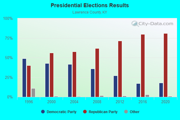
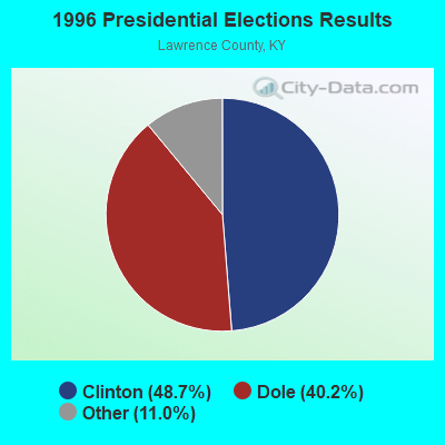
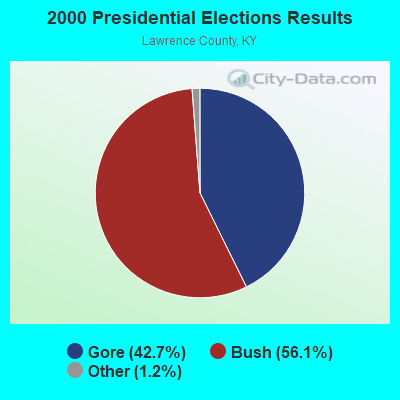
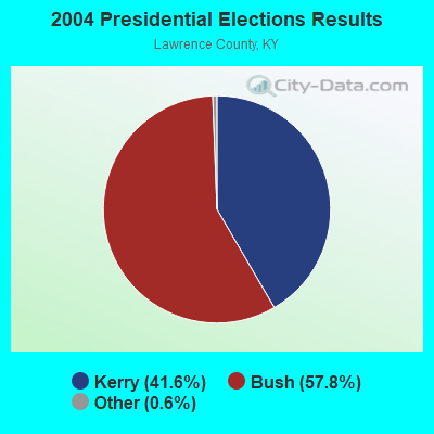
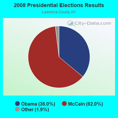
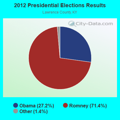
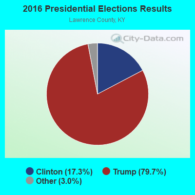
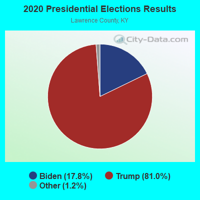
Graphs represent county-level data. Detailed 2008 Election Results
Religion statistics for Webbville, KY (based on Lawrence County data)
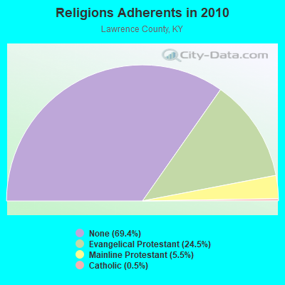
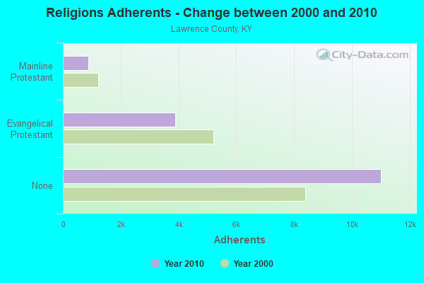
| Religion | Adherents | Congregations |
|---|---|---|
| Evangelical Protestant | 3,892 | 34 |
| Mainline Protestant | 870 | 8 |
| Catholic | 86 | 1 |
| Other | 1 | 1 |
| None | 11,011 | - |
Food Environment Statistics:
| Lawrence County: | 2.45 / 10,000 pop. |
| State: | 2.19 / 10,000 pop. |
| This county: | 0.61 / 10,000 pop. |
| Kentucky: | 0.25 / 10,000 pop. |
| Lawrence County: | 1.23 / 10,000 pop. |
| Kentucky: | 0.74 / 10,000 pop. |
| This county: | 7.97 / 10,000 pop. |
| State: | 4.36 / 10,000 pop. |
| Lawrence County: | 2.45 / 10,000 pop. |
| Kentucky: | 5.74 / 10,000 pop. |
| This county: | 11.6% |
| Kentucky: | 11.0% |
| Lawrence County: | 32.6% |
| State: | 30.0% |
| Here: | 21.6% |
| Kentucky: | 15.9% |
Strongest AM radio stations in Webbville:
- WGOH (1370 AM; 5 kW; GRAYSON, KY; Owner: CARTER COUNTY BROADCASTING CO., INC.)
- WKYH (600 AM; 5 kW; PAINTSVILLE, KY; Owner: HIGHLANDS BROADCASTING CORPORATION)
- WVHU (800 AM; 5 kW; HUNTINGTON, WV; Owner: CAPSTAR TX LIMITED PARTNERSHIP)
- WRVC (930 AM; 5 kW; HUNTINGTON, WV; Owner: FIFTH AVENUE BROADCASTING COMPANY, INC.)
- WTCR (1420 AM; 5 kW; KENOVA, WV; Owner: CAPSTAR TX LIMITED PARTNERSHIP)
- WTVN (610 AM; 50 kW; COLUMBUS, OH; Owner: CITICASTERS LICENSES, L.P.)
- WOKT (1040 AM; daytime; 2 kW; CANNONSBURG, KY; Owner: BIG RIVER RADIO, INC.-KY)
- WHRD (1470 AM; 5 kW; HUNTINGTON, WV; Owner: CONCORD MEDIA GROUP, INC.)
- WLW (700 AM; 50 kW; CINCINNATI, OH; Owner: JACOR BROADCASTING CORPORATION)
- WPRT (960 AM; 5 kW; PRESTONSBURG, KY; Owner: EAST KENTUCKY RADIO NETWORK, INC.)
- WDOC (1310 AM; 5 kW; PRESTONSBURG, KY)
- WLGC (1520 AM; daytime; 5 kW; GREENUP, KY; Owner: GREENUP COUNTY BROADCASTING, INC.)
- WCAW (680 AM; 10 kW; CHARLESTON, WV; Owner: WEST VIRGINIA RADIO CORPORATION OF CHARLESTON)
Strongest FM radio stations in Webbville:
- WZAQ (92.3 FM; LOUISA, KY; Owner: LOUISA COMMUNICATIONS, INC.)
- WDGG (93.7 FM; ASHLAND, KY; Owner: FIFTH AVENUE B/CASTING COMPANY, INC.)
- WPAY-FM (104.1 FM; PORTSMOUTH, OH; Owner: RADIO STATIONS WPAY/WPFB, INC.)
- WKLW-FM (94.7 FM; PAINTSVILLE, KY; Owner: B & G BROADCASTING, INC.)
- WQHY (95.5 FM; PRESTONSBURG, KY; Owner: WDOC, INC.)
- WUGO (102.3 FM; GRAYSON, KY; Owner: CARTER COUNTY BROADCASTING CO., INC.)
- WBKS (107.1 FM; IRONTON, OH; Owner: CAPSTAR TX LIMITED PARTNERSHIP)
- WKLC-FM (105.1 FM; ST. ALBANS, WV; Owner: WKLC, INC.)
- WMKY (90.3 FM; MOREHEAD, KY; Owner: MOREHEAD STATE UNIVERSITY)
- WVWV (89.9 FM; HUNTINGTON, WV; Owner: WEST VIRGINIA EDUCATIONAL BROADCASTING AUTHORITY)
- WSIP-FM (98.9 FM; PAINTSVILLE, KY; Owner: SIP BROADCASTING, INC.)
- WAMX (106.3 FM; MILTON, WV; Owner: CAPSTAR TX LIMITED PARTNERSHIP)
- WKEE-FM (100.5 FM; HUNTINGTON, WV; Owner: CAPSTAR TX LIMITED PARTNERSHIP)
- WFGH (90.7 FM; FORT GAY, WV; Owner: WAYNE COUNTY BOARD OF EDUCATION)
- WOSP (91.5 FM; PORTSMOUTH, OH; Owner: THE OHIO STATE UNIVERSITY)
- WRVC-FM (92.7 FM; CATLETTSBURG, KY; Owner: FIFTH AVENUE BROADCASTING CO., INC)
- WBVB (97.1 FM; COAL GROVE, OH; Owner: CAPSTAR TX LIMITED PARTNERSHIP)
- WTCR-FM (103.3 FM; HUNTINGTON, WV; Owner: CAPSTAR TX LIMITED PARTNERSHIP)
- WOUL-FM (89.1 FM; IRONTON, OH; Owner: OHIO UNIVERSITY)
- WLGC-FM (105.7 FM; GREENUP, KY; Owner: GREENUP COUNTY BROADCASTING, INC.)
TV broadcast stations around Webbville:
- WPBY-TV (Channel 33; HUNTINGTON, WV; Owner: WEST VIRGINIA EDUCATIONAL BROADCASTING AUTHORITY)
- WVAH-TV (Channel 11; CHARLESTON, WV; Owner: WVAH LICENSEE, LLC)
- WSAZ-TV (Channel 3; HUNTINGTON, WV; Owner: EMMIS TELEVISION LICENSE CORPORATION)
- WOWK-TV (Channel 13; HUNTINGTON, WV; Owner: WEST VIRGINIA MEDIA HOLDINGS, LLC)
- WCHS-TV (Channel 8; CHARLESTON, WV; Owner: WCHS LICENSEE, LLC)
- WUPX-TV (Channel 67; MOREHEAD, KY; Owner: PAXSON LEXINGTON LICENSE, INC.)
- WKAS (Channel 25; ASHLAND, KY; Owner: KENTUCKY AUTHORITY FOR EDUCATIONAL TV)
- W14CU (Channel 14; HUNTINGTON, WV; Owner: VENTANA TELEVISION, INC.)
- WKMR (Channel 38; MOREHEAD, KY; Owner: KENTUCKY AUTHORITY FOR EDUCATIONAL TV)
- W49BN (Channel 49; HUNTINGTON, WV; Owner: PAXSON COMMUNCATIONS LPTV, INC.)
- WTSF (Channel 61; ASHLAND, KY; Owner: TRI STATE FAMILY BROADCASTING, INC.)
Webbville fatal accident list:
FCC Registered Antenna Towers:
4- W.A. Gillum, Located On Bays Branch Of Caney Creek, Webbville (Lawerence County), Ky (Lat: 38.154806 Lon: -82.846139), Type: 94.5, Structure height: 21127 m, Overall height: 91.4 m, Registrant: East Kentucky Network, LLC D/B/A Appalachian Wireless, Compliance@ekn.Com, , Ivel, Phone: (606) 477-2355
- W.A. Gillum, Located On Bays Branch Of Caney Creek, Webbville (Lawerence County), Ky (Lat: 38.154806 Lon: -82.846139), Type: 94.5, Structure height: 21127 m, Overall height: 91.4 m, Licensee ID: L, Registrant: East Kentucky Network, LLC D/B/A Appalachian Wireless, Compliance@ekn.Com, , Ivel, Phone: (606) 477-2355
- W.A. Gillum, Located On Bays Branch Of Caney Creek, Webbville (Lawerence County), Ky (Lat: 38.154806 Lon: -82.846139), Type: 94.5, Structure height: 21127 m, Overall height: 91.4 m, Registrant: East Kentucky Network, LLC D/B/A Appalachian Wireless, Compliance@ekn.Com, , Ivel, Phone: (606) 477-2355
- Michael L Johnson, Located On Bays Branch Of Caney Creek, Webbville (Lawerence County), Ky (Lat: 38.154806 Lon: -82.846139), Type: 94.5, Structure height: 21127 m, Overall height: 91.4 m, Registrant: East Kentucky Network, LLC D/B/A Appalachian Wireless, Compliance@ekn.Com, , Ivel, Phone: (606) 477-2355
FCC Registered Amateur Radio Licenses:
8 (See the full list of FCC Registered Amateur Radio Licenses in Webbville)
- 55.7%Electricity
- 18.1%Bottled, tank, or LP gas
- 10.1%Fuel oil, kerosene, etc.
- 9.0%Wood
- 3.8%Coal or coke
- 3.3%Utility gas

- 47.1%Electricity
- 36.4%Bottled, tank, or LP gas
- 10.7%Fuel oil, kerosene, etc.
- 5.8%Coal or coke
Webbville compared to Kentucky state average:
- Median house value below state average.
- Unemployed percentage below state average.
- Black race population percentage significantly below state average.
- Hispanic race population percentage significantly below state average.
- Median age below state average.
- Foreign-born population percentage significantly below state average.
- Renting percentage below state average.
- Length of stay since moving in significantly above state average.
- Number of rooms per house significantly below state average.
- House age significantly below state average.
- Number of college students below state average.
- Percentage of population with a bachelor's degree or higher significantly below state average.