Property valuation of N Uber Street, Philadelphia, PA: 1949, 1950, 1952, 2110, 2111, 2112, 2113, 2114, 2115, 2116 (tax assessments)
Other nearby streets: Diamond Street  Fontain Street (1)
Fontain Street (2)
Fontain Street (3)
Fontain Street (4)
Fontain Street (1)
Fontain Street (2)
Fontain Street (3)
Fontain Street (4)
Fontain Street (1)
Fontain Street (2)
Fontain Street (3)
Fontain Street (4)
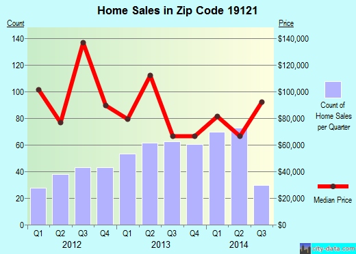
Listed properties vs overall distribution of properties in Philadelphia, PA:
Advertisements
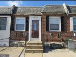
1949 N Uber Street
Philadelphia, PA 19121
Find on map >>
Owner: URBAN REAL ESTATE LLC
Assessed land value: $6,974 (it was $167 in 2009)
Assessed building value: $122,726 (it was $1,369 in 2009)
Total assessed value for property: $129,700 (it was $1,536 in 2009)
Market value: $129,700
Date of last market value change: 01/2013
Sale price: $18,500
Date the deed was transferred: 10/17/2008
Sale type: Sale deferred for closer review by Evaluation staff
Status of construction: Finished
Category: Hotels and Apartments
Site type: Inside location on the block
Frontage: 14 feet
Depth: 77.82 feet
Shape: Rectangular
Topography: Street level
Garage type: None
View: Typical
Number of stories: 2
Date the exterior condition was observed: 10/18/2012
Exterior condition: Rehabilitated
Year property was built: 1915 (estimated)
Number of rooms: 6
Number of bedrooms: 3
Number of bathrooms: 1
Connection to sewer: Yes
Land area: 1,089.61 square feet
Total dwelling livable area: 1,048 square feet
Assessments for tax year: 2014
1950 N Uber Street
Philadelphia, PA 19121
Find on map >>
Owner: CITY OF PHILA DEPT O/PUBLIC PROPERTY
Total assessed value for property: $0
Market value: $7,100
Date of last market value change: 01/2013
Sale price: $1
Date the deed was transferred: 12/14/1971
Status of construction: Finished
Category: Vacant Land
Frontage: 15 feet
Depth: 74.82 feet
Shape: Rectangular
Topography: Street level
Garage type: None
View: Typical
Connection to sewer: Yes
Land area: 1,122.45 square feet
Assessments for tax year: 2014
1952 N Uber Street
Philadelphia, PA 19121
Find on map >>
Owner: CITY OF PHILA
Total assessed value for property: $0
Market value: $7,100
Date of last market value change: 01/2013
Sale price: $1
Date the deed was transferred: 07/21/1970
Status of construction: Finished
Category: Vacant Land
Frontage: 15 feet
Depth: 74.82 feet
Shape: Rectangular
Topography: Street level
Garage type: None
View: Typical
Connection to sewer: Yes
Land area: 1,122.45 square feet
Assessments for tax year: 2014
2110 N Uber Street
Philadelphia, PA 19121
Find on map >>
Owner: CITY OF PHILA DEPT OF PUBLIC PROP.
Total assessed value for property: $0
Market value: $10,900
Date of last market value change: 01/2013
Sale price: $1
Date the deed was transferred: 08/17/1981
Sale type: Sales between related parties, i.e. Grantor/Grantee, Owner/Tenant
Status of construction: Finished
Category: Vacant Land
Frontage: 20 feet
Depth: 86.40 feet
Shape: Rectangular
Topography: Street level
Garage type: None
View: Typical
Connection to sewer: Yes
Land area: 1,728.20 square feet
Assessments for tax year: 2014
2111 N Uber Street
Philadelphia, PA 19121
Find on map >>
Owner: CITY OF PHILA DEPT OF PUBLIC PROP
Total assessed value for property: $0
Market value: $10,900
Date of last market value change: 01/2013
Sale price: $500
Date the deed was transferred: 07/15/1985
Sale type: Forced, Sheriff, Bankruptcy or Court-ordered Sales, Condemnation, Deed in lieu of Condemnation
Status of construction: Finished
Category: Vacant Land
Frontage: 20 feet
Depth: 86.40 feet
Shape: Rectangular
Topography: Street level
Garage type: None
View: Typical
Connection to sewer: Yes
Land area: 1,728.20 square feet
Assessments for tax year: 2014
2112 N Uber Street
Philadelphia, PA 19121
Find on map >>
Owner: PHILA HOUSING AUTHORITY
Total assessed value for property: $0
Market value: $10,900
Date of last market value change: 01/2013
Sale price: $1
Date the deed was transferred: 10/03/1968
Status of construction: Finished
Category: Vacant Land
Frontage: 20 feet
Depth: 86.40 feet
Shape: Rectangular
Topography: Street level
Garage type: None
View: Typical
Connection to sewer: Yes
Land area: 1,728.20 square feet
Assessments for tax year: 2014
2113 N Uber Street
Philadelphia, PA 19121
Find on map >>
Owner: CITY OF PHILA DEPT OF PUBLIC PROP
Total assessed value for property: $0
Market value: $10,900
Date of last market value change: 01/2013
Sale price: $500
Date the deed was transferred: 07/22/1985
Sale type: Forced, Sheriff, Bankruptcy or Court-ordered Sales, Condemnation, Deed in lieu of Condemnation
Status of construction: Finished
Category: Vacant Land
Frontage: 20 feet
Depth: 86.40 feet
Shape: Rectangular
Topography: Street level
Garage type: None
View: Typical
Connection to sewer: Yes
Land area: 1,728.20 square feet
Assessments for tax year: 2014
2114 N Uber Street
Philadelphia, PA 19121
Find on map >>
Owner: WILLIAMS E GERALDINE WILLIAMS SIDNEY
Assessed land value: $11,579 (it was $380 in 2009)
Assessed building value: $109,421 (it was $1,732 in 2009)
Total assessed value for property: $121,000 (it was $2,112 in 2009)
Market value: $121,000
Date of last market value change: 01/2013
Sale price: $1
Date the deed was transferred: 04/24/1978
Sale type: Sales between related parties, i.e. Grantor/Grantee, Owner/Tenant
Status of construction: Finished
Category: Residential
Frontage: 20 feet
Depth: 86.40 feet
Shape: Rectangular
Topography: Street level
Garage type: None
View: Typical
Date the exterior condition was observed: 08/21/2000
Exterior condition: Average
Year property was built: 1915 (estimated)
Floor plan: Triplex (built as)
Connection to sewer: Yes
Land area: 1,728.20 square feet
Total dwelling livable area: 2,240 square feet
Assessments for tax year: 2014
2115 N Uber Street
Philadelphia, PA 19121
Find on map >>
Owner: CITY OF PHILA DEPT OF PUBLC PROP
Total assessed value for property: $0
Market value: $10,900
Date of last market value change: 01/2013
Sale price: $500
Date the deed was transferred: 02/25/1985
Sale type: Forced, Sheriff, Bankruptcy or Court-ordered Sales, Condemnation, Deed in lieu of Condemnation
Status of construction: Finished
Category: Vacant Land
Frontage: 20 feet
Depth: 86.40 feet
Shape: Rectangular
Topography: Street level
Garage type: None
View: Typical
Connection to sewer: Yes
Land area: 1,728.20 square feet
Assessments for tax year: 2014
2116 N Uber Street
Philadelphia, PA 19121
Find on map >>
Owner: KENNARD JOHNSON
Assessed land value: $10,999 (it was $264 in 2009)
Assessed building value: $107,001 (it was $1,848 in 2009)
Total assessed value for property: $118,000 (it was $2,112 in 2009)
Market value: $118,000
Date of last market value change: 01/2013
Sale price: $1
Date the deed was transferred: 10/12/2001
Sale type: Sales between related parties, i.e. Grantor/Grantee, Owner/Tenant
Status of construction: Finished
Category: Hotels and Apartments
Frontage: 20 feet
Depth: 86.40 feet
Shape: Rectangular
Topography: Street level
Garage type: None
View: Typical
Date the exterior condition was observed: 08/21/2000
Exterior condition: Average
Year property was built: 1915 (estimated)
Floor plan: Triplex (built as)
Connection to sewer: Yes
Land area: 1,728.20 square feet
Total dwelling livable area: 1,976 square feet
Assessments for tax year: 2014
Other nearby streets: Diamond Street
Fontain Street (1)
Fontain Street (2)
Fontain Street (3)
Fontain Street (4)
Fontain Street (1)
Fontain Street (2)
Fontain Street (3)
Fontain Street (4)

Recent posts about Philadelphia, Pennsylvania on our local forum with over 2,400,000 registered users. Philadelphia is mentioned 39,635 times on our forum:

Settings
X

Recently Added Photos

Philadelphia, PA
Philadelphia, PA
Philadelphia, PA

Philadelphia, PA
Philadelphia, PA
Philadelphia, PA
Philadelphia, PA
Philadelphia, PA

Philadelphia, PA

Philadelphia, PA

Philadelphia, PA

Philadelphia, PA
Request disassociating your name from street-level assessment address

Recent home sales, price trends, and home value evaluator powered by Onboard Informatics
© 2024 Onboard Informatics. Information is deemed reliable but not guaranteed.
© 2024 Onboard Informatics. Information is deemed reliable but not guaranteed.
Some parts © 2024 Advameg, Inc.
Compilation, repackaging, or reproduction prohibited. Users are forewarned that it is incumbent upon them to verify information with the responsible state agency. Advameg, Inc. does not guarantee the data presented is up-to-date nor does it assume responsibility for updating it. Therefore any names, owners or addresses may have changed. Use of any information published here to contact the persons might be prohibited by the law.