Bridge Statistics for Albany, New York (NY)
Condition, Traffic, Stress, Structural Evaluation, Project Costs
- National Bridge Inventory (NBI) Statistics
- 311Number of bridges
- 6,102ft / 1,860mTotal length
- $1,155,153,000Total costs
- 4,524,777Total average daily traffic
- 184,101Total average daily truck traffic
- National Bridge Inventory (NBI) Registered Bridges for Albany
- No street view available for this location
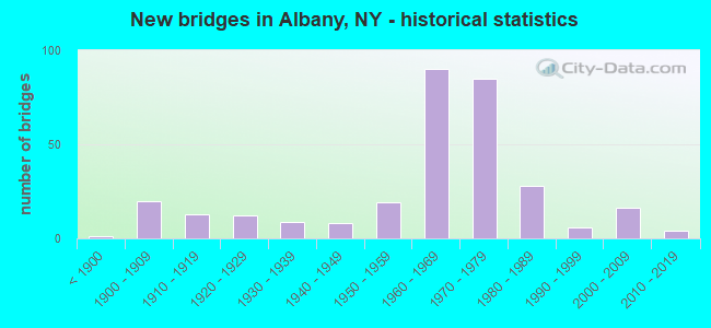
- New bridges - historical statistics
- 1Before 1900
- 201900-1909
- 131910-1919
- 121920-1929
- 91930-1939
- 81940-1949
- 191950-1959
- 901960-1969
- 851970-1979
- 281980-1989
- 61990-1999
- 162000-2009
- 42010-2019
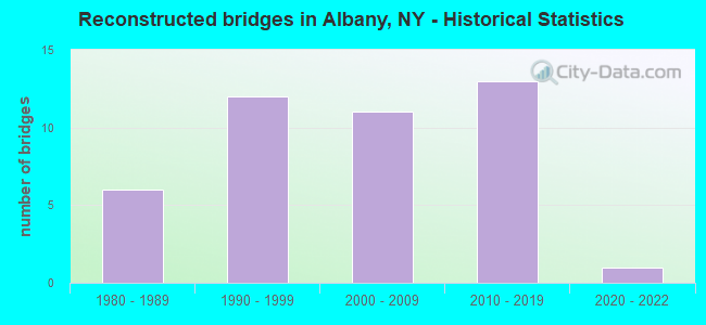
- Reconstructed bridges - Historical Statistics
- 61980-1989
- 121990-1999
- 112000-2009
- 132010-2019
- 12020-2022
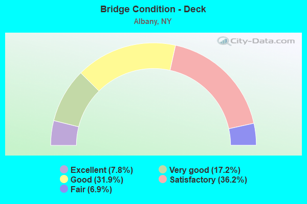
- Bridge Condition - Deck
- 7.8%Excellent
- 17.2%Very good
- 31.9%Good
- 36.2%Satisfactory
- 6.9%Fair
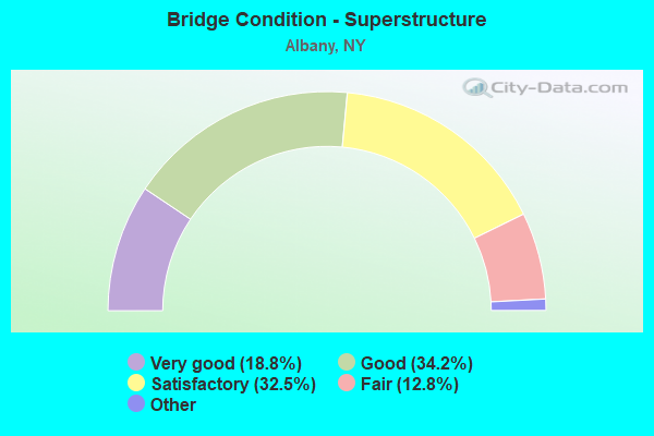
- Bridge Condition - Superstructure
- 18.8%Excellent
- 34.2%Very good
- 32.5%Good
- 12.8%Satisfactory
- 1.7%Fair
- 0.9%Poor
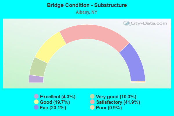
- Bridge Condition - Substructure
- 4.3%Excellent
- 10.3%Very good
- 19.7%Good
- 41.9%Satisfactory
- 23.1%Fair
- 0.9%Poor
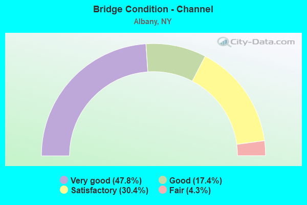
- Bridge Condition - Channel
- 47.8%Very good
- 17.4%Good
- 30.4%Satisfactory
- 4.3%Fair
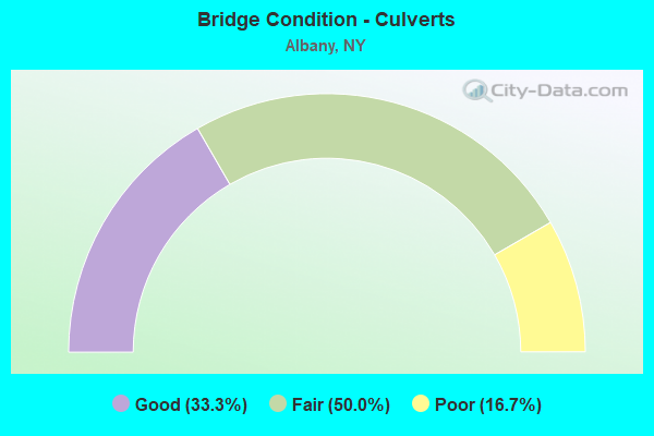
- Bridge Condition - Culverts
- 33.3%Good
- 50.0%Fair
- 16.7%Poor
Find on map >> Show street view
Structure Number: 1094131, Location: CITY OF ALBANY SOUTH MALL (Lat: 42.649475, Lng: -73.757981), Route carried "on" structure: City street 913, Year Built: 1976, Status: Open, Structure Length: 2.10m (6.89ft), Average Daily Traffic: 6,671 (year 2011), Truck Traffic: 4%, Average Future Daily Traffic: 7,730 (year 2040), Design Load: HS 20+Mod, Features Intersected: EAGLE STREET
Minimum Vertical Clearance: 30+ m (98+ ft), Kilometerpoint: 0.418, Lanes on structure: 2, Lanes under structure: 2, Base Highway Network: Yes, Owner: State Highway Agency, Approaching Roadway Width: 18.9m (62.0ft), Material/Design: Steel, Design/Construction: Stringer/Multi-beam, Number Of Spans In Main Unit: 1, Length of Maximum Span: 19.2m (63.0ft), Curb or Sidewalk Widths: Left: 0.6m (2.0ft), Right: 0.6m (2.0ft), Curb-To-Curb Width: 9.8m (32.2ft), Out-to-Out Width: 23.0m (75.5ft)
Condition: Deck: Fair, Superstructure: Good, Substructure: Satisfactory, Operating Rating: 59.0 metric tons, Method Used To Determine Operating Rating: Load and Resistance Factor Rating (LRFR) rating reported by rating factor(RF) method using HL-93 loadings, Inventory Rating: 45.4 metric tons, Method Used To Determine Inventory Rating: Load and Resistance Factor Rating (LRFR) rating reported by rating factor(RF) method using HL-93 loadings, Structural Evaluation: Equal to present minimum criteria, Deck Geometry: High priority of replacement, Underclear: Somewhat better than minimum adequacy, Approach Roadway Alignment: Equal to present desirable criteria, Length Of Structure Improvement: 2.10m (6.89ft), Designated Inspection Frequency: Every 24 months, Inspection Date: August 2021, Bridge Improvement Cost: $2,102,000, Roadway Improvement Cost: $1,231,000, Total Project Cost: $3,333,000 ( Estimate for 2021), Deck Structure Type: Concrete Cast-file-Place, Wearing Surface/Protective System: Wearing Surface: Epoxy Overlay
Find on map >> Show street view
Structure Number: 1094132, Location: CITY OF ALBANY SOUTH MALL (Lat: 42.649217, Lng: -73.758217), Route carried "on" structure: City street 913, Year Built: 1976, Status: Open, Structure Length: 2.10m (6.89ft), Average Daily Traffic: 6,671 (year 2011), Truck Traffic: 4%, Average Future Daily Traffic: 7,730 (year 2040), Design Load: HS 20+Mod, Features Intersected: EAGLE STREET
Minimum Vertical Clearance: 30+ m (98+ ft), Kilometerpoint: 0.418, Lanes on structure: 2, Lanes under structure: 2, Base Highway Network: Yes, Owner: State Highway Agency, Approaching Roadway Width: 9.8m (32.2ft), Material/Design: Steel, Design/Construction: Stringer/Multi-beam, Number Of Spans In Main Unit: 1, Length of Maximum Span: 19.2m (63.0ft), Curb or Sidewalk Widths: Left: 0.6m (2.0ft), Right: 0.6m (2.0ft), Curb-To-Curb Width: 13.7m (44.9ft), Out-to-Out Width: 23.0m (75.5ft)
Condition: Deck: Satisfactory, Superstructure: Good, Substructure: Satisfactory, Operating Rating: 59.0 metric tons, Method Used To Determine Operating Rating: Load and Resistance Factor Rating (LRFR) rating reported by rating factor(RF) method using HL-93 loadings, Inventory Rating: 45.4 metric tons, Method Used To Determine Inventory Rating: Load and Resistance Factor Rating (LRFR) rating reported by rating factor(RF) method using HL-93 loadings, Structural Evaluation: Equal to present minimum criteria, Deck Geometry: Superior to present desirable criteria, Underclear: Somewhat better than minimum adequacy, Approach Roadway Alignment: Equal to present desirable criteria, Length Of Structure Improvement: 2.10m (6.89ft), Designated Inspection Frequency: Every 24 months, Inspection Date: August 2021, Bridge Improvement Cost: $2,102,000, Roadway Improvement Cost: $1,231,000, Total Project Cost: $3,333,000 ( Estimate for 2021), Deck Structure Type: Concrete Cast-file-Place, Wearing Surface/Protective System: Wearing Surface: Epoxy Overlay
Find on map >> Show street view
Structure Number: 1095889, Location: 1.1 MI E JCT I90 & S.H.85 (Lat: 42.683728, Lng: -73.784128), Route carried "on" structure: ServiceCounty highway , Year Built: 1965, Status: Open, Structure Length: 7.65m (25.10ft), Average Daily Traffic: 18,133 (year 2011), Truck Traffic: 6%, Average Future Daily Traffic: 22,027 (year 2040), Design Load: HS 20, Features Intersected: CSX TRANS/ AMTRAK, Facility Carried by Structure: EVERETT ROAD
Minimum Vertical Clearance: 30+ m (98+ ft), Kilometerpoint: 0.676, Lanes on structure: 4, Owner: State Highway Agency, Approaching Roadway Width: 21.3m (69.9ft), Skew: 30 degrees, Material/Design: Steel, Design/Construction: Stringer/Multi-beam, Number Of Spans In Main Unit: 4, Length of Maximum Span: 21.3m (69.9ft), Curb or Sidewalk Widths: Left: 0.0m, Right: 1.2m (3.9ft), Curb-To-Curb Width: 21.3m (69.9ft), Out-to-Out Width: 23.5m (77.1ft)
Condition: Deck: Satisfactory, Superstructure: Good, Substructure: Satisfactory, Operating Rating: 66.1 metric tons, Method Used To Determine Operating Rating: Load and Resistance Factor Rating (LRFR) rating reported by rating factor(RF) method using HL-93 loadings, Inventory Rating: 50.9 metric tons, Method Used To Determine Inventory Rating: Load and Resistance Factor Rating (LRFR) rating reported by rating factor(RF) method using HL-93 loadings, Structural Evaluation: Equal to present minimum criteria, Deck Geometry: Superior to present desirable criteria, Underclear: Somewhat better than minimum adequacy, Approach Roadway Alignment: Equal to present desirable criteria, Length Of Structure Improvement: 7.65m (25.10ft), Designated Inspection Frequency: Every 24 months, Inspection Date: September 2021, Bridge Improvement Cost: $3,782,000, Roadway Improvement Cost: $2,215,000, Total Project Cost: $5,997,000 ( Estimate for 2021), Deck Structure Type: Concrete Cast-file-Place, Wearing Surface/Protective System: Wearing Surface: Integral Concrete
Find on map >> Show street view
Structure Number: 220027, Location: NORTHERN BLVD CITY ALBANY (Lat: 42.658661, Lng: -73.764386), Route carried "on" structure: City street , Year Built: 1980, Year Reconstructed: 2018, Status: Open, Structure Length: 13.78m (45.21ft), Average Daily Traffic: 10,984 (year 2019), Truck Traffic: 2%, Average Future Daily Traffic: 11,035 (year 2040), Design Load: HS 20, Features Intersected: SHERMAN STREET, ELK STRE, Facility Carried by Structure: HENRY JOHNSON BVD
Minimum Vertical Clearance: 30+ m (98+ ft), Kilometerpoint: 0.209, Lanes on structure: 2, Lanes under structure: 4, Owner: City or Municipal Highway Agency, Approaching Roadway Width: 9.8m (32.2ft), Material/Design: Steel continuous, Design/Construction: Stringer/Multi-beam, Number Of Spans In Main Unit: 4, Length of Maximum Span: 41.1m (134.8ft), Curb or Sidewalk Widths: Left: 0.0m, Right: 2.2m (7.2ft), Curb-To-Curb Width: 9.8m (32.2ft), Out-to-Out Width: 12.8m (42.0ft)
Condition: Deck: Satisfactory, Superstructure: Very good, Substructure: Good, Operating Rating: 74.4 metric tons, Method Used To Determine Operating Rating: Load Factor (LF), Inventory Rating: 44.5 metric tons, Method Used To Determine Inventory Rating: Load Factor (LF), Structural Evaluation: Better than present minimum criteria, Deck Geometry: Meets minimum limits, Underclear: High priority of corrective action, Approach Roadway Alignment: Equal to present desirable criteria, Length Of Structure Improvement: 13.77m (45.18ft), Designated Inspection Frequency: Every 24 months, Inspection Date: April 2021, Bridge Improvement Cost: $3,858,000, Roadway Improvement Cost: $2,259,000, Total Project Cost: $6,117,000 ( Estimate for 2021), Deck Structure Type: Concrete Cast-file-Place, Wearing Surface/Protective System: Wearing Surface: Epoxy Overlay, Deck Protection: Epoxy Coated Reinforcing
Find on map >> Show street view
Structure Number: 22475, Location: IN MIDDLE VILLAGE (Lat: 40.712267, Lng: -73.888764), Route carried "on" structure: City street , Year Built: 1916, Status: Open, Structure Length: 1.10m (3.61ft), Average Daily Traffic: 14,046 (year 2019), Truck Traffic: 7%, Average Future Daily Traffic: 14,112 (year 2040), Features Intersected: CSX TRANS/CPR&P&W, Facility Carried by Structure: METROPOLITAN AVE
Minimum Vertical Clearance: 30+ m (98+ ft), Kilometerpoint: 2.977, Lanes on structure: 4, Owner: City or Municipal Highway Agency, Approaching Roadway Width: 13.7m (44.9ft), Material/Design: Concrete, Design/Construction: Frame, Number Of Spans In Main Unit: 1, Length of Maximum Span: 9.1m (29.9ft), Curb or Sidewalk Widths: Left: 2.6m (8.5ft), Right: 4.0m (13.1ft), Curb-To-Curb Width: 13.7m (44.9ft), Out-to-Out Width: 157.9m (518.0ft)
Condition: Deck: Satisfactory, Superstructure: Poor, Substructure: Satisfactory, Operating Rating: 89.8 metric tons, Method Used To Determine Operating Rating: Load Factor (LF), Inventory Rating: 47.2 metric tons, Method Used To Determine Inventory Rating: Load Factor (LF), Structural Evaluation: Meets minimum limits, Deck Geometry: High priority of replacement, Underclear: High priority of corrective action, Approach Roadway Alignment: Equal to present desirable criteria, Length Of Structure Improvement: 1.09m (3.58ft), Designated Inspection Frequency: Every 24 months, Inspection Date: October 2021, Bridge Improvement Cost: $23,188,000, Roadway Improvement Cost: $13,579,000, Total Project Cost: $36,767,000 ( Estimate for 2021), Deck Structure Type: Concrete Cast-file-Place, Wearing Surface/Protective System: Wearing Surface: Bituminous
Find on map >> Show street view
Structure Number: 22482, Location: AT MASPETH (Lat: 40.717800, Lng: -73.909686), Route carried "on" structure: City street , Year Built: 1960, Year Reconstructed: 1987, Status: Open, Structure Length: 2.16m (7.09ft), Average Daily Traffic: 13,264 (year 2018), Truck Traffic: 13%, Average Future Daily Traffic: 16,113 (year 2040), Features Intersected: FLUSHING AVENUE, Facility Carried by Structure: RUST STREET
Minimum Vertical Clearance: 30+ m (98+ ft), Kilometerpoint: 0.756, Lanes on structure: 2, Lanes under structure: 4, Owner: City or Municipal Highway Agency, Approaching Roadway Width: 9.1m (29.9ft), Material/Design: Prestressed concrete, Design/Construction: Stringer/Multi-beam, Number Of Spans In Main Unit: 1, Length of Maximum Span: 21.3m (69.9ft), Curb or Sidewalk Widths: Left: 2.2m (7.2ft), Right: 0.9m (3.0ft), Curb-To-Curb Width: 9.1m (29.9ft), Out-to-Out Width: 12.8m (42.0ft)
Condition: Deck: Very good, Superstructure: Satisfactory, Substructure: Fair, Operating Rating: 55.3 metric tons, Method Used To Determine Operating Rating: Load Factor (LF), Inventory Rating: 33.6 metric tons, Method Used To Determine Inventory Rating: Load Factor (LF), Structural Evaluation: Somewhat better than minimum adequacy, Deck Geometry: High priority of corrective action, Underclear: High priority of corrective action, Approach Roadway Alignment: Equal to present desirable criteria, Length Of Structure Improvement: 2.16m (7.09ft), Designated Inspection Frequency: Every 24 months, Inspection Date: June 2021, Bridge Improvement Cost: $2,854,000, Roadway Improvement Cost: $1,671,000, Total Project Cost: $4,525,000 ( Estimate for 2021), Deck Structure Type: Concrete Cast-file-Place, Wearing Surface/Protective System: Wearing Surface: Monolithic Concrete
Find on map >> Show street view
Structure Number: 225684, Location: .8 MI NE JCT SH 32 & I787 (Lat: 42.640547, Lng: -73.751911), Route carried "on" structure: City street , Year Built: 1900, Status: Open, Structure Length: 1.43m (4.69ft), Truck Traffic: 10%, Features Intersected: BEAVER RELIEF SEWER, Facility Carried by Structure: ALBANY CITY STREET
Minimum Vertical Clearance: 30+ m (98+ ft), Kilometerpoint: 0.595, Lanes on structure: 2, Owner: City or Municipal Highway Agency, Approaching Roadway Width: 7.3m (24.0ft), Material/Design: Concrete continuous, Design/Construction: Culvert, Number Of Spans In Main Unit: 2, Length of Maximum Span: 6.7m (22.0ft), Curb or Sidewalk Widths: Left: 1.8m (5.9ft), Right: 1.8m (5.9ft)
Condition: Channel: Very good, Culverts: Fair, Operating Rating: 51.8 metric tons, Method Used To Determine Operating Rating: Field evaluation and documented engineering judgment, Inventory Rating: 22.0 metric tons, Method Used To Determine Inventory Rating: Field evaluation and documented engineering judgment, Structural Evaluation: Somewhat better than minimum adequacy, Waterway Adequacy: Somewhat better than minimum adequacy, Approach Roadway Alignment: Equal to present desirable criteria, Length Of Structure Improvement: 1.43m (4.69ft), Designated Inspection Frequency: Every 24 months, Underwater Inspection Frequency: Every 60 months, Inspection Date: November 2021, Underwater Inspection Date: July 2017, Bridge Improvement Cost: $405,000, Roadway Improvement Cost: $237,000, Total Project Cost: $642,000 ( Estimate for 2021)
Find on map >> Show street view
Structure Number: 5513549, Location: .56 MI SE EXIT 23 OF I87 (Lat: 42.625669, Lng: -73.779081), Route carried "on" structure: Interstate 87, Year Built: 1954, Year Reconstructed: 1998, Status: Open, Structure Length: 18.87m (61.91ft), Average Daily Traffic: 37,550 (year 2020), Truck Traffic: 25%, Average Future Daily Traffic: 59,505 (year 2040), Design Load: HS 20+Mod, Features Intersected: Normans Kill, Rail Trail
Minimum Vertical Clearance: 30+ m (98+ ft), Kilometerpoint: 18.761, Lanes on structure: 4, Base Highway Network: Yes, Toll: On Interstate toll segment, Owner: State Toll Authority, Approaching Roadway Width: 33.2m (108.9ft), Skew: 22 degrees, Material/Design: Steel continuous, Design/Construction: Truss - Deck, Number Of Spans In Main Unit: 3, Number Of Approach Spans: 2, Length of Maximum Span: 73.2m (240.2ft), Curb-To-Curb Width: 33.8m (110.9ft), Out-to-Out Width: 35.4m (116.1ft)
Condition: Deck: Satisfactory, Superstructure: Fair, Substructure: Fair, Channel: Satisfactory, Operating Rating: 50.8 metric tons, Method Used To Determine Operating Rating: Load Factor (LF), Inventory Rating: 30.8 metric tons, Method Used To Determine Inventory Rating: Load Factor (LF), Structural Evaluation: Somewhat better than minimum adequacy, Deck Geometry: Superior to present desirable criteria, Waterway Adequacy: Superior to present desirable criteria, Approach Roadway Alignment: Equal to present desirable criteria, Length Of Structure Improvement: 18.86m (61.88ft), Designated Inspection Frequency: Every 24 months, Critical Feature Inspection Frequency: Every 24 months, Inspection Date: November 2020, Critical Feature Inspection Date: November 2020, Bridge Improvement Cost: $42,843,000, Roadway Improvement Cost: $25,089,000, Total Project Cost: $67,932,000 ( Estimate for 2021), Deck Structure Type: Concrete Cast-file-Place, Wearing Surface/Protective System: Wearing Surface: Bituminous, Membrane: Other, Deck Protection: Galvanized Reinforcing
Find on map >> Show street view
Structure Number: 551355, Location: NB EXIT 23 RAMP OF I87 (Lat: 42.633117, Lng: -73.780144), Route carried "on" structure: Ramp Interstate , Year Built: 1997, Status: Open, Structure Length: 1.34m (4.40ft), Average Daily Traffic: 5,128 (year 2018), Truck Traffic: 18%, Average Future Daily Traffic: 8,126 (year 2040), Design Load: HS 25 or greater, Features Intersected: NOONAN LANE, Facility Carried by Structure: 87IX NB OFF RAMP
Minimum Vertical Clearance: 30+ m (98+ ft), Kilometerpoint: 0.676, Lanes on structure: 1, Lanes under structure: 2, Toll: On Interstate toll segment, Owner: State Toll Authority, Approaching Roadway Width: 7.9m (25.9ft), Material/Design: Prestressed concrete, Design/Construction: Frame, Number Of Spans In Main Unit: 1, Length of Maximum Span: 12.8m (42.0ft), Curb-To-Curb Width: 7.9m (25.9ft), Out-to-Out Width: 9.6m (31.5ft)
Condition: Deck: Good, Superstructure: Good, Substructure: Good, Operating Rating: 81.6 metric tons, Method Used To Determine Operating Rating: Field evaluation and documented engineering judgment, Inventory Rating: 40.8 metric tons, Method Used To Determine Inventory Rating: Field evaluation and documented engineering judgment, Structural Evaluation: Better than present minimum criteria, Deck Geometry: Equal to present desirable criteria, Underclear: Meets minimum limits, Approach Roadway Alignment: High priority of corrective action, Length Of Structure Improvement: 1.34m (4.40ft), Designated Inspection Frequency: Every 24 months, Inspection Date: November 2021, Bridge Improvement Cost: $391,000, Roadway Improvement Cost: $229,000, Total Project Cost: $619,000 ( Estimate for 2021)
Find on map >> Show street view
Structure Number: 5513561, Location: INT 23 ON I87 (Lat: 42.633228, Lng: -73.781639), Route carried "on" structure: Interstate 871, Year Built: 1954, Year Reconstructed: 2013, Status: Open, Structure Length: 2.93m (9.61ft), Average Daily Traffic: 17,351 (year 2020), Truck Traffic: 29%, Average Future Daily Traffic: 27,495 (year 2040), Design Load: HS 20+Mod, Features Intersected: 87IX INT 23 RAMP, NOONAN
Minimum Vertical Clearance: 30+ m (98+ ft), Kilometerpoint: 19.742, Lanes on structure: 2, Lanes under structure: 4, Base Highway Network: Yes, Toll: On Interstate toll segment, Owner: State Toll Authority, Approaching Roadway Width: 16.5m (54.1ft), Material/Design: Steel, Design/Construction: Stringer/Multi-beam, Number Of Spans In Main Unit: 2, Length of Maximum Span: 14.0m (45.9ft), Curb-To-Curb Width: 16.5m (54.1ft), Out-to-Out Width: 17.1m (56.1ft)
Condition: Deck: Good, Superstructure: Good, Substructure: Fair, Operating Rating: 81.6 metric tons, Method Used To Determine Operating Rating: Load Factor (LF), Inventory Rating: 48.1 metric tons, Method Used To Determine Inventory Rating: Load Factor (LF), Structural Evaluation: Somewhat better than minimum adequacy, Deck Geometry: Superior to present desirable criteria, Underclear: High priority of corrective action, Approach Roadway Alignment: Equal to present desirable criteria, Length Of Structure Improvement: 2.92m (9.58ft), Designated Inspection Frequency: Every 24 months, Inspection Date: April 2021, Bridge Improvement Cost: $1,887,000, Roadway Improvement Cost: $1,105,000, Total Project Cost: $2,991,000 ( Estimate for 2021), Deck Structure Type: Concrete Cast-file-Place, Wearing Surface/Protective System: Wearing Surface: Monolithic Concrete
Find on map >> Show street view
Structure Number: 5513562, Location: INT 23 ON I87 (Lat: 42.633081, Lng: -73.781856), Route carried "on" structure: Interstate 87, Year Built: 1954, Year Reconstructed: 2013, Status: Open, Structure Length: 2.93m (9.61ft), Average Daily Traffic: 2,332 (year 2018), Truck Traffic: 18%, Average Future Daily Traffic: 3,694 (year 2040), Design Load: HS 20+Mod, Features Intersected: INT 23 RAMP, NOONAN LANE
Minimum Vertical Clearance: 30+ m (98+ ft), Kilometerpoint: 0.981, Lanes on structure: 3, Lanes under structure: 4, Toll: On Interstate toll segment, Owner: State Toll Authority, Approaching Roadway Width: 19.2m (63.0ft), Skew: 10 degrees, Material/Design: Steel, Design/Construction: Stringer/Multi-beam, Number Of Spans In Main Unit: 2, Length of Maximum Span: 14.0m (45.9ft), Curb-To-Curb Width: 19.2m (63.0ft), Out-to-Out Width: 20.1m (65.9ft)
Condition: Deck: Satisfactory, Superstructure: Good, Substructure: Satisfactory, Operating Rating: 70.3 metric tons, Method Used To Determine Operating Rating: Load and Resistance Factor Rating (LRFR) rating reported by rating factor(RF) method using HL-93 loadings, Inventory Rating: 54.1 metric tons, Method Used To Determine Inventory Rating: Load and Resistance Factor Rating (LRFR) rating reported by rating factor(RF) method using HL-93 loadings, Structural Evaluation: Equal to present minimum criteria, Deck Geometry: Superior to present desirable criteria, Underclear: High priority of corrective action, Approach Roadway Alignment: Equal to present desirable criteria, Length Of Structure Improvement: 2.92m (9.58ft), Designated Inspection Frequency: Every 24 months, Inspection Date: April 2021, Bridge Improvement Cost: $2,247,000, Roadway Improvement Cost: $1,316,000, Total Project Cost: $3,563,000 ( Estimate for 2021), Deck Structure Type: Concrete Cast-file-Place, Wearing Surface/Protective System: Wearing Surface: Bituminous, Membrane: Other
Find on map >> Show street view
Structure Number: 551357, Location: WATER TUNNEL (Lat: 42.640539, Lng: -73.797053), Route carried "on" structure: Interstate 87, Year Built: 1954, Status: Open, Structure Length: 0.64m (2.10ft), Average Daily Traffic: 34,701 (year 2020), Truck Traffic: 29%, Average Future Daily Traffic: 54,990 (year 2040), Design Load: HS 20+Mod, Features Intersected: CITY WATER TUNNEL
Minimum Vertical Clearance: 30+ m (98+ ft), Kilometerpoint: 21.271, Lanes on structure: 6, Base Highway Network: Yes, Toll: On Interstate toll segment, Owner: City or Municipal Highway Agency, Maintenance Responsibility: State Toll Authority, Approaching Roadway Width: 49.0m (160.8ft), Skew: 20 degrees, Material/Design: Concrete, Design/Construction: Slab, Number Of Spans In Main Unit: 1, Length of Maximum Span: 6.1m (20.0ft), Curb-To-Curb Width: 49.0m (160.8ft), Out-to-Out Width: 65.8m (215.9ft)
Condition: Deck: Good, Superstructure: Satisfactory, Substructure: Satisfactory, Operating Rating: 76.9 metric tons, Method Used To Determine Operating Rating: Field evaluation and documented engineering judgment, Inventory Rating: 32.7 metric tons, Method Used To Determine Inventory Rating: Field evaluation and documented engineering judgment, Structural Evaluation: Equal to present minimum criteria, Deck Geometry: Superior to present desirable criteria, Approach Roadway Alignment: Equal to present desirable criteria, Length Of Structure Improvement: 0.64m (2.10ft), Designated Inspection Frequency: Every 24 months, Inspection Date: July 2021, Bridge Improvement Cost: $2,397,000, Roadway Improvement Cost: $1,403,000, Total Project Cost: $3,800,000 ( Estimate for 2021)
Find on map >> Show street view
Structure Number: 551358, Location: 2.39MI NW INT23 ON I87 (Lat: 42.653736, Lng: -73.819089), Route carried "on" structure: City street , Year Built: 1954, Status: Open, Structure Length: 7.59m (24.90ft), Average Daily Traffic: 7,115 (year 2018), Truck Traffic: 3%, Average Future Daily Traffic: 8,643 (year 2040), Design Load: HS 20+Mod, Features Intersected: 87IX SB, RTE I87, Facility Carried by Structure: NEW SCOTLAND AVE
Minimum Vertical Clearance: 30+ m (98+ ft), Kilometerpoint: 4.360, Lanes on structure: 2, Lanes under structure: 6, Owner: State Toll Authority, Approaching Roadway Width: 16.8m (55.1ft), Skew: 21 degrees, Material/Design: Steel, Design/Construction: Stringer/Multi-beam, Number Of Spans In Main Unit: 4, Length of Maximum Span: 19.8m (65.0ft), Curb or Sidewalk Widths: Left: 2.3m (7.5ft), Right: 1.5m (4.9ft), Curb-To-Curb Width: 16.7m (54.8ft), Out-to-Out Width: 21.1m (69.2ft)
Condition: Deck: Good, Superstructure: Satisfactory, Substructure: Good, Operating Rating: 57.7 metric tons, Method Used To Determine Operating Rating: Load and Resistance Factor Rating (LRFR) rating reported by rating factor(RF) method using HL-93 loadings, Inventory Rating: 44.4 metric tons, Method Used To Determine Inventory Rating: Load and Resistance Factor Rating (LRFR) rating reported by rating factor(RF) method using HL-93 loadings, Structural Evaluation: Equal to present minimum criteria, Deck Geometry: Superior to present desirable criteria, Underclear: Meets minimum limits, Approach Roadway Alignment: Equal to present desirable criteria, Length Of Structure Improvement: 7.58m (24.87ft), Designated Inspection Frequency: Every 24 months, Inspection Date: June 2020, Bridge Improvement Cost: $3,494,000, Roadway Improvement Cost: $2,046,000, Total Project Cost: $5,540,000 ( Estimate for 2021), Deck Structure Type: Concrete Cast-file-Place, Wearing Surface/Protective System: Wearing Surface: Bituminous, Membrane: Other, Deck Protection: Epoxy Coated Reinforcing
Find on map >> Show street view
Structure Number: 5513599, Location: 3 MI SE EXIT 24 ON I87 (Lat: 42.659944, Lng: -73.826342), Route carried "on" structure: Interstate 87, Year Built: 1952, Year Reconstructed: 2000, Status: Open, Structure Length: 1.49m (4.89ft), Average Daily Traffic: 34,701 (year 2020), Truck Traffic: 29%, Average Future Daily Traffic: 54,990 (year 2040), Design Load: HS 25 or greater, Features Intersected: KRUMKILL RD
Minimum Vertical Clearance: 30+ m (98+ ft), Kilometerpoint: 24.489, Lanes on structure: 6, Lanes under structure: 2, Base Highway Network: Yes, Toll: On Interstate toll segment, Owner: State Toll Authority, Approaching Roadway Width: 37.5m (123.0ft), Skew: 21 degrees, Material/Design: Prestressed concrete, Design/Construction: Box Beam or Girders - Multiple, Number Of Spans In Main Unit: 1, Length of Maximum Span: 13.7m (44.9ft), Curb-To-Curb Width: 37.4m (122.7ft), Out-to-Out Width: 38.6m (126.6ft)
Condition: Deck: Good, Superstructure: Very good, Substructure: Good, Operating Rating: 59.9 metric tons, Method Used To Determine Operating Rating: Load and Resistance Factor Rating (LRFR) rating reported by rating factor(RF) method using HL-93 loadings, Inventory Rating: 46.3 metric tons, Method Used To Determine Inventory Rating: Load and Resistance Factor Rating (LRFR) rating reported by rating factor(RF) method using HL-93 loadings, Structural Evaluation: Better than present minimum criteria, Deck Geometry: Superior to present desirable criteria, Underclear: Somewhat better than minimum adequacy, Approach Roadway Alignment: Equal to present desirable criteria, Length Of Structure Improvement: 1.49m (4.89ft), Designated Inspection Frequency: Every 24 months, Inspection Date: August 2020, Bridge Improvement Cost: $4,261,000, Roadway Improvement Cost: $2,495,000, Total Project Cost: $6,757,000 ( Estimate for 2021), Deck Structure Type: Concrete Cast-file-Place, Wearing Surface/Protective System: Wearing Surface: Monolithic Concrete, Deck Protection: Galvanized Reinforcing
Find on map >> Show street view
Structure Number: 100762, Location: JCT OF US 9W & I787 (Lat: 42.633511, Lng: -73.775097), Route carried "under" structure: Interstate 787, Year Built: 1966, Structure Length: 0. m, Average Daily Traffic: 48,103 (year 2002), Features Intersected: I-787 (SB), RTE I787, Facility Carried by Structure: RTE 9W
Minimum Vertical Clearance: 5.05m (16.57ft), Kilometerpoint: 0.531, Lanes on structure: 4, Lanes under structure: 2, Material/Design: Steel, Design/Construction: Stringer/Multi-beam, Length of Maximum Span: 25.3m (83.0ft)
Find on map >> Show street view
Structure Number: 101598, Location: JCT RTS 20 & 85 (Lat: 42.671667, Lng: -73.808092), Route carried "under" structure: State highway 85, Year Built: 1960, Structure Length: 0. m, Average Daily Traffic: 12,600 (year 1972), Features Intersected: 85 85 11012010 EB, RTE, Facility Carried by Structure: RTE 20
Minimum Vertical Clearance: 4.45m (14.60ft), Kilometerpoint: 1.722, Lanes on structure: 4, Lanes under structure: 3, Material/Design: Steel, Design/Construction: Stringer/Multi-beam, Length of Maximum Span: 17.3m (56.8ft)
Find on map >> Show street view
Structure Number: 1022479, Location: JCT RT 32 & I787 (Lat: 42.633264, Lng: -73.763850), Route carried "under" structure: Alternate City street , Year Built: 1966, Structure Length: 0. m, Average Daily Traffic: 4,954 (year 2013), Features Intersected: SO.PEARL ST.RT.32, Facility Carried by Structure: RTE I787
Minimum Vertical Clearance: 4.60m (15.09ft), Kilometerpoint: 0.000, Lanes on structure: 7, Lanes under structure: 2, Material/Design: Steel, Design/Construction: Stringer/Multi-beam, Length of Maximum Span: 35.9m (117.8ft)
Find on map >> Show street view
Structure Number: 102531, Location: RTE 443 OVER NORMANSKILL (Lat: 42.633928, Lng: -73.798058), Route carried "under" structure: City street , Year Built: 1996, Structure Length: 0. m, Average Daily Traffic: 100 (year 2021), Features Intersected: OLD BRICK RD, MILL ROAD,, Facility Carried by Structure: RTE 443
Minimum Vertical Clearance: 6.71m (22.01ft), Kilometerpoint: 0.000, Lanes on structure: 2, Lanes under structure: 2, Material/Design: Steel continuous, Design/Construction: Stringer/Multi-beam, Length of Maximum Span: 80.7m (264.8ft)
Find on map >> Show street view
Structure Number: 102532, Location: JCT RTE 443 & I87 TO I90 (Lat: 42.637403, Lng: -73.790719), Route carried "under" structure: Interstate 87, Year Built: 1952, Structure Length: 0. m, Average Daily Traffic: 46,162 (year 2014), Features Intersected: 87IX NB, RTE I87, Facility Carried by Structure: RTE 443
Minimum Vertical Clearance: 5.05m (16.57ft), Kilometerpoint: 229.234, Lanes on structure: 3, Lanes under structure: 3, Toll: On Interstate toll segment, Material/Design: Steel, Design/Construction: Stringer/Multi-beam, Length of Maximum Span: 19.8m (65.0ft)
Find on map >> Show street view
Structure Number: 1033101, Location: .4MI N JCT 87I+WASH AV.EX (Lat: 42.695017, Lng: -73.838850), Route carried "under" structure: Interstate 90, Year Built: 1959, Structure Length: 0. m, Average Daily Traffic: 20,636 (year 1999), Features Intersected: 90I 90I 11011001-WB, RT, Facility Carried by Structure: RTE I87
Minimum Vertical Clearance: 4.55m (14.93ft), Kilometerpoint: 0.386, Lanes on structure: 3, Lanes under structure: 2, Material/Design: Steel, Design/Construction: Stringer/Multi-beam, Length of Maximum Span: 17.0m (55.8ft)
Find on map >> Show street view
Structure Number: 1033102, Location: .4MI N JCT 87I+WASH.AV.EX (Lat: 42.695000, Lng: -73.838611), Route carried "under" structure: Interstate 90, Year Built: 1959, Structure Length: 0. m, Average Daily Traffic: 20,636 (year 1999), Features Intersected: 90I 90I 11011001- WB, R, Facility Carried by Structure: RTE I87
Minimum Vertical Clearance: 4.95m (16.24ft), Kilometerpoint: 0.402, Lanes on structure: 3, Lanes under structure: 2, Material/Design: Steel, Design/Construction: Stringer/Multi-beam, Length of Maximum Span: 17.6m (57.7ft)
Find on map >> Show street view
Structure Number: 1034479, Location: JCT OF I90 & FULLER RD (Lat: 42.694108, Lng: -73.830233), Route carried "under" structure: County highway , Year Built: 1968, Structure Length: 0. m, Average Daily Traffic: 11,720 (year 2019), Truck Traffic: 5%, Features Intersected: FULLER RD -CR 156, Facility Carried by Structure: RTE I90
Minimum Vertical Clearance: 4.78m (15.68ft), Kilometerpoint: 2.237, Lanes on structure: 8, Lanes under structure: 4, Material/Design: Steel, Design/Construction: Stringer/Multi-beam, Length of Maximum Span: 18.8m (61.7ft)
Find on map >> Show street view
Structure Number: 1034489, Location: 1.2 MI E JCT I90 & CR 156 (Lat: 42.687400, Lng: -73.809306), Route carried "under" structure: Interstate 90, Year Built: 1968, Structure Length: 0. m, Average Daily Traffic: 20,672 (year 2000), Features Intersected: 90I 90I11011018 WB, RTE, Facility Carried by Structure: CAMPUS CONNECTOR
Minimum Vertical Clearance: 5.79m (19.00ft), Kilometerpoint: 2.896, Lanes on structure: 2, Lanes under structure: 3, Material/Design: Steel, Design/Construction: Stringer/Multi-beam, Length of Maximum Span: 29.8m (97.8ft)
Find on map >> Show street view
Structure Number: 1034491, Location: JCT I90 & RTE 85 (Lat: 42.686600, Lng: -73.803500), Route carried "under" structure: Interstate 90, Year Built: 1968, Structure Length: 0. m, Average Daily Traffic: 20,672 (year 2000), Features Intersected: 90I 90I11011021 WB, RTE, Facility Carried by Structure: RTE 85
Minimum Vertical Clearance: 5.18m (16.99ft), Kilometerpoint: 3.459, Lanes on structure: 2, Lanes under structure: 4, Material/Design: Steel, Design/Construction: Stringer/Multi-beam, Length of Maximum Span: 38.4m (126.0ft)
Find on map >> Show street view
Structure Number: 1034492, Location: JCT I90 & RTE 85 (Lat: 42.686803, Lng: -73.802872), Route carried "under" structure: Interstate 90, Year Built: 1968, Structure Length: 0. m, Average Daily Traffic: 20,672 (year 2000), Features Intersected: 90I 90I11011021 WB, RTE, Facility Carried by Structure: RTE 85
Minimum Vertical Clearance: 6.12m (20.08ft), Kilometerpoint: 3.459, Lanes on structure: 1, Lanes under structure: 4, Material/Design: Steel, Design/Construction: Stringer/Multi-beam, Length of Maximum Span: 34.7m (113.8ft)
Find on map >> Show street view
Structure Number: 1034519, Location: JCT I90 & RTE 5 (Lat: 42.687269, Lng: -73.798289), Route carried "under" structure: State highway , Year Built: 1968, Structure Length: 0. m, Average Daily Traffic: 48,472 (year 2004), Features Intersected: CENTRAL AVE (SR5), Facility Carried by Structure: RTE I90
Minimum Vertical Clearance: 4.62m (15.16ft), Kilometerpoint: 590.744, Lanes on structure: 9, Lanes under structure: 5, Material/Design: Steel, Design/Construction: Stringer/Multi-beam, Length of Maximum Span: 39.6m (129.9ft)
Find on map >> Show street view
Structure Number: 1034529, Location: EXIT 5 OF I90 (Lat: 42.682506, Lng: -73.784864), Route carried "under" structure: Interstate 90, Year Built: 1965, Structure Length: 0. m, Average Daily Traffic: 20,672 (year 2000), Features Intersected: 90I 90I11011031-WB, RTE, Facility Carried by Structure: EVERETT ROAD
Minimum Vertical Clearance: 5.31m (17.42ft), Kilometerpoint: 5.149, Lanes on structure: 6, Lanes under structure: 3, Material/Design: Steel, Design/Construction: Stringer/Multi-beam, Length of Maximum Span: 17.3m (56.8ft)
Find on map >> Show street view
Structure Number: 103865, Location: ROUTE 155 OVER 90IX (Lat: 42.714383, Lng: -73.869231), Route carried "under" structure: Interstate 90, Year Built: 1999, Structure Length: 0. m, Average Daily Traffic: 68,800 (year 1999), Features Intersected: 90IX EB, RTE I90, Facility Carried by Structure: RTE 155
Minimum Vertical Clearance: 5.23m (17.16ft), Kilometerpoint: 240.626, Lanes on structure: 2, Lanes under structure: 3, Toll: On Interstate toll segment, Material/Design: Steel continuous, Design/Construction: Stringer/Multi-beam, Length of Maximum Span: 33.2m (108.9ft)
Find on map >> Show street view
Structure Number: 1049669, Location: 0.2 MI E JCT RT 9W & I787 (Lat: 42.633231, Lng: -73.772392), Route carried "under" structure: Ramp Interstate , Year Built: 1962, Structure Length: 0. m, Average Daily Traffic: 17,200 (year 1979), Features Intersected: TWY CONN WB RAMP, Facility Carried by Structure: RTE I787
Minimum Vertical Clearance: 4.62m (15.16ft), Kilometerpoint: 0.563, Lanes on structure: 5, Lanes under structure: 2, Material/Design: Steel, Design/Construction: Stringer/Multi-beam, Length of Maximum Span: 22.3m (73.2ft)
Find on map >> Show street view
Structure Number: 105446, Location: 0.1 MI S JCT RT 9W & I787 (Lat: 42.632792, Lng: -73.775347), Route carried "under" structure: Interstate 787, Year Built: 1966, Structure Length: 0. m, Average Daily Traffic: 11,600 (year 1972), Features Intersected: 787 SB, RTE I787, Facility Carried by Structure: RTE 9W
Minimum Vertical Clearance: 4.45m (14.60ft), Kilometerpoint: 0.161, Lanes on structure: 4, Lanes under structure: 2, Material/Design: Steel, Design/Construction: Stringer/Multi-beam, Length of Maximum Span: 22.8m (74.8ft)
Find on map >> Show street view
Structure Number: 106031, Location: 0.8 MI S JCT RTS 20 & 85 (Lat: 42.663308, Lng: -73.818461), Route carried "under" structure: State highway 85, Year Built: 2000, Structure Length: 0. m, Average Daily Traffic: 27,600 (year 1997), Features Intersected: 85 85 11012002, RTE 85, Facility Carried by Structure: KRUMKILL ROAD
Minimum Vertical Clearance: 4.67m (15.32ft), Kilometerpoint: 0.467, Lanes on structure: 3, Lanes under structure: 2, Material/Design: Steel continuous, Design/Construction: Stringer/Multi-beam, Length of Maximum Span: 20.4m (66.9ft)
Find on map >> Show street view
Structure Number: 106032, Location: 0.4 MI S JCT RTS 20 & 85 (Lat: 42.667603, Lng: -73.812867), Route carried "under" structure: City street , Year Built: 2008, Structure Length: 0. m, Average Daily Traffic: 2,196 (year 2019), Truck Traffic: 2%, Features Intersected: BERKSHIRE BLVD, Facility Carried by Structure: RTE 85
Minimum Vertical Clearance: 5.18m (16.99ft), Kilometerpoint: 0.579, Lanes on structure: 5, Lanes under structure: 2, Material/Design: Concrete, Design/Construction: Frame, Length of Maximum Span: 11.5m (37.7ft)
Find on map >> Show street view
Structure Number: 106034, Location: .2 MI N JCT RTS 20 & 85 (Lat: 42.673772, Lng: -73.805689), Route carried "under" structure: State highway 85, Year Built: 2000, Structure Length: 0. m, Average Daily Traffic: 27,777 (year 1998), Features Intersected: 85 85 11012012, RTE 85, Facility Carried by Structure: CAMPUS ACCESS RD
Minimum Vertical Clearance: 4.65m (15.26ft), Kilometerpoint: 2.092, Lanes on structure: 2, Lanes under structure: 3, Material/Design: Steel continuous, Design/Construction: Stringer/Multi-beam, Length of Maximum Span: 25.0m (82.0ft)
Find on map >> Show street view
Structure Number: 106035, Location: .5 MI N JCT SH 20 & SH 85 (Lat: 42.677614, Lng: -73.802228), Route carried "under" structure: State highway 85, Year Built: 2000, Structure Length: 0. m, Average Daily Traffic: 27,777 (year 1998), Features Intersected: 85 85 11012015, RTE 85,, Facility Carried by Structure: CAMPUS ACCESS RD
Minimum Vertical Clearance: 5.79m (19.00ft), Kilometerpoint: 2.590, Lanes on structure: 3, Lanes under structure: 3, Material/Design: Steel continuous, Design/Construction: Stringer/Multi-beam, Length of Maximum Span: 30.0m (98.4ft)
Find on map >> Show street view
Structure Number: 106035, Location: .5 MI N JCT SH 20 & SH 85 (Lat: 42.677614, Lng: -73.802228), Route carried "under" structure: State highway , Year Built: 2000, Structure Length: 0. m, Average Daily Traffic: 1,228 (year 2014), Features Intersected: 85 85 11012015, RTE 85,, Facility Carried by Structure: CAMPUS ACCESS RD
Minimum Vertical Clearance: 5.05m (16.57ft), Kilometerpoint: 2.590, Lanes on structure: 3, Lanes under structure: 1, Material/Design: Steel continuous, Design/Construction: Stringer/Multi-beam, Length of Maximum Span: 30.0m (98.4ft)
Find on map >> Show street view
Structure Number: 106036, Location: 0.7 MI N JCT RTS 20 & 85 (Lat: 42.679044, Lng: -73.801856), Route carried "under" structure: State highway 85, Year Built: 1960, Structure Length: 0. m, Average Daily Traffic: 27,777 (year 1998), Features Intersected: 85 85 11012016, RTE 85, Facility Carried by Structure: WASHINGTON AVENUE
Minimum Vertical Clearance: 4.57m (14.99ft), Kilometerpoint: 2.719, Lanes on structure: 4, Lanes under structure: 3, Material/Design: Steel, Design/Construction: Stringer/Multi-beam, Length of Maximum Span: 20.4m (66.9ft)
Find on map >> Show street view
Structure Number: 1073511, Location: JCT I87 OVER I90 (Lat: 42.694428, Lng: -73.839222), Route carried "under" structure: Ramp Interstate , Year Built: 1987, Structure Length: 0. m, Average Daily Traffic: 9,586 (year 1989), Features Intersected: FR I90E TO I87N, Facility Carried by Structure: RTE 910F
Minimum Vertical Clearance: 5.49m (18.01ft), Kilometerpoint: 0.322, Lanes on structure: 3, Lanes under structure: 2, Material/Design: Steel, Design/Construction: Stringer/Multi-beam, Length of Maximum Span: 37.7m (123.7ft)
Find on map >> Show street view
Structure Number: 1073512, Location: JCT I87 OVER I90 (Lat: 42.694325, Lng: -73.839044), Route carried "under" structure: Ramp Interstate , Year Built: 1987, Structure Length: 0. m, Average Daily Traffic: 9,586 (year 1989), Features Intersected: FR I90 E TO I87 N, Facility Carried by Structure: RTE 910F
Minimum Vertical Clearance: 5.94m (19.49ft), Kilometerpoint: 0.483, Lanes on structure: 2, Lanes under structure: 2, Material/Design: Steel, Design/Construction: Stringer/Multi-beam, Length of Maximum Span: 37.7m (123.7ft)
Find on map >> Show street view
Structure Number: 1073521, Location: JCT I87 OVER I90 (Lat: 42.692981, Lng: -73.840133), Route carried "under" structure: Ramp Interstate , Year Built: 1987, Structure Length: 0. m, Average Daily Traffic: 16,102 (year 1989), Features Intersected: FR I87 S TO I90 E, Facility Carried by Structure: RTE 910F
Minimum Vertical Clearance: 5.66m (18.57ft), Kilometerpoint: 1.126, Lanes on structure: 3, Lanes under structure: 2, Material/Design: Steel, Design/Construction: Stringer/Multi-beam, Length of Maximum Span: 39.6m (129.9ft)
Find on map >> Show street view
Structure Number: 1073522, Location: JCT I87 OVER I90 (Lat: 42.692908, Lng: -73.839933), Route carried "under" structure: Ramp Interstate , Year Built: 1986, Structure Length: 0. m, Average Daily Traffic: 16,102 (year 1989), Features Intersected: FR I87 S TO I90 E, Facility Carried by Structure: RTE 910F
Minimum Vertical Clearance: 6.20m (20.34ft), Kilometerpoint: 0.000, Lanes on structure: 2, Lanes under structure: 2, Material/Design: Steel, Design/Construction: Stringer/Multi-beam, Length of Maximum Span: 39.6m (129.9ft)
Find on map >> Show street view
Structure Number: 107353, Location: RAMP SE OVER I90 (Lat: 42.695739, Lng: -73.841403), Route carried "under" structure: Interstate 90, Year Built: 1989, Structure Length: 0. m, Average Daily Traffic: 20,100 (year 1989), Features Intersected: 90I 90I 1101 1000 WB, RT, Facility Carried by Structure: RTE I87
Minimum Vertical Clearance: 6.45m (21.16ft), Kilometerpoint: 0.177, Lanes on structure: 2, Lanes under structure: 4, Material/Design: Steel continuous, Design/Construction: Stringer/Multi-beam, Length of Maximum Span: 35.0m (114.8ft)
Find on map >> Show street view
Structure Number: 107354, Location: EXIT 24 THRUWAY TO I87 NB (Lat: 42.694853, Lng: -73.835492), Route carried "under" structure: Interstate 90, Year Built: 1987, Structure Length: 0. m, Average Daily Traffic: 12,000 (year 1989), Features Intersected: 90I 90I11011004 WB, RTE, Facility Carried by Structure: RTE 87
Minimum Vertical Clearance: 5.05m (16.57ft), Kilometerpoint: 0.644, Lanes on structure: 2, Lanes under structure: 2, Material/Design: Steel continuous, Design/Construction: Stringer/Multi-beam, Length of Maximum Span: 39.0m (128.0ft)
Find on map >> Show street view
Structure Number: 107355, Location: N OF EXIT 24 OVER I90 (Lat: 42.701456, Lng: -73.848628), Route carried "under" structure: Interstate , Year Built: 1986, Structure Length: 0. m, Average Daily Traffic: 16,630 (year 1989), Features Intersected: 90IX EB, 90IX, Facility Carried by Structure: RAMP 87IX
Minimum Vertical Clearance: 5.16m (16.93ft), Kilometerpoint: 238.389, Lanes on structure: 2, Lanes under structure: 2, Toll: On Interstate toll segment, Material/Design: Steel continuous, Design/Construction: Stringer/Multi-beam, Length of Maximum Span: 36.9m (121.1ft)
Find on map >> Show street view
Structure Number: 107356, Location: .1 MI N OF EXIT 24 OF I90 (Lat: 42.702106, Lng: -73.847483), Route carried "under" structure: Interstate , Year Built: 1986, Structure Length: 0. m, Average Daily Traffic: 31,020 (year 1989), Features Intersected: 90IX EB, 90IX, Facility Carried by Structure: RTE I87
Minimum Vertical Clearance: 6.05m (19.85ft), Kilometerpoint: 238.373, Lanes on structure: 2, Lanes under structure: 2, Toll: On Interstate toll segment, Material/Design: Steel continuous, Design/Construction: Stringer/Multi-beam, Length of Maximum Span: 48.2m (158.1ft)
Find on map >> Show street view
Structure Number: 107357, Location: RAPP RD.OVER TWY. (Lat: 42.702747, Lng: -73.850769), Route carried "under" structure: Interstate 901X, Year Built: 1986, Structure Length: 0. m, Average Daily Traffic: 16,630 (year 1989), Features Intersected: 90 I WB, RAMP 90IX/T WB, Facility Carried by Structure: RAPP ROAD
Minimum Vertical Clearance: 5.54m (18.18ft), Kilometerpoint: 238.599, Lanes on structure: 2, Lanes under structure: 2, Toll: On Interstate toll segment, Material/Design: Steel continuous, Design/Construction: Stringer/Multi-beam, Length of Maximum Span: 56.4m (185.0ft)
Find on map >> Show street view
Structure Number: 107357, Location: RAPP RD.OVER TWY. (Lat: 42.702747, Lng: -73.850769), Route carried "under" structure: Interstate , Year Built: 1986, Structure Length: 0. m, Average Daily Traffic: 31,020 (year 1989), Features Intersected: 90 I WB, RAMP 90IX/T WB, Facility Carried by Structure: RAPP ROAD
Minimum Vertical Clearance: 5.72m (18.77ft), Kilometerpoint: 238.599, Lanes on structure: 2, Lanes under structure: 2, Toll: On Interstate toll segment, Material/Design: Steel continuous, Design/Construction: Stringer/Multi-beam, Length of Maximum Span: 56.4m (185.0ft)
Find on map >> Show street view
Structure Number: 107358, Location: .2 MI W OF EXIT 24 TOLL (Lat: 42.705039, Lng: -73.853742), Route carried "under" structure: Interstate 90, Year Built: 1989, Structure Length: 0. m, Average Daily Traffic: 8,000 (year 1989), Features Intersected: RTE I90
Minimum Vertical Clearance: 5.41m (17.75ft), Kilometerpoint: 238.937, Lanes on structure: 2, Lanes under structure: 2, Toll: On Interstate toll segment, Material/Design: Steel, Design/Construction: Stringer/Multi-beam, Length of Maximum Span: 48.2m (158.1ft)
Find on map >> Show street view
Structure Number: 107944, Location: WASHINGTON AVE. EXT. OVER (Lat: 42.693306, Lng: -73.830869), Route carried "under" structure: Alternate County highway , Year Built: 2012, Structure Length: 0. m, Average Daily Traffic: 14,040 (year 2008), Features Intersected: Fuller Rd, Facility Carried by Structure: RTE 910
Minimum Vertical Clearance: 5.03m (16.50ft), Kilometerpoint: 0.000, Lanes on structure: 4, Lanes under structure: 2, Material/Design: Steel, Design/Construction: Stringer/Multi-beam, Length of Maximum Span: 29.0m (95.1ft)
Find on map >> Show street view
Structure Number: 107945, Location: Washington ave. ext. over (Lat: 42.693189, Lng: -73.830361), Route carried "under" structure: Alternate County highway , Year Built: 2012, Structure Length: 0. m, Average Daily Traffic: 14,040 (year 2008), Features Intersected: Fuller rd. rounda, Facility Carried by Structure: RTE 910
Minimum Vertical Clearance: 5.13m (16.83ft), Kilometerpoint: 0.000, Lanes on structure: 4, Lanes under structure: 2, Material/Design: Steel, Design/Construction: Stringer/Multi-beam, Length of Maximum Span: 29.0m (95.1ft)
Find on map >> Show street view
Structure Number: 1092421, Location: JCT I90 & I787 (Lat: 42.667403, Lng: -73.732833), Route carried "under" structure: Interstate 787, Year Built: 1968, Structure Length: 0. m, Average Daily Traffic: 11,050 (year 1972), Features Intersected: 787I787I11011038, 90I 90, Facility Carried by Structure: RTE I90
Minimum Vertical Clearance: 5.79m (19.00ft), Kilometerpoint: 6.130, Lanes on structure: 1, Lanes under structure: 2, Material/Design: Steel, Design/Construction: Stringer/Multi-beam, Length of Maximum Span: 19.5m (64.0ft)
Find on map >> Show street view
Structure Number: 1092421, Location: JCT I90 & I787 (Lat: 42.667403, Lng: -73.732833), Route carried "under" structure: Ramp Interstate 90, Year Built: 1968, Structure Length: 0. m, Average Daily Traffic: 100 (year 2021), Features Intersected: 787I787I11011038, 90I 90
Minimum Vertical Clearance: 5.13m (16.83ft), Kilometerpoint: 20.837, Lanes on structure: 1, Lanes under structure: 2, Material/Design: Steel, Design/Construction: Stringer/Multi-beam, Length of Maximum Span: 19.5m (64.0ft)
Find on map >> Show street view
Structure Number: 1092422, Location: JCT I90 & I787 (Lat: 42.667267, Lng: -73.733417), Route carried "under" structure: Interstate 787, Year Built: 1968, Structure Length: 0. m, Average Daily Traffic: 48,200 (year 1977), Features Intersected: 787I787I11011038, 90I 90, Facility Carried by Structure: RTE I90
Minimum Vertical Clearance: 5.21m (17.09ft), Kilometerpoint: 6.130, Lanes on structure: 1, Lanes under structure: 2, Material/Design: Steel, Design/Construction: Stringer/Multi-beam, Length of Maximum Span: 19.5m (64.0ft)
Find on map >> Show street view
Structure Number: 1092422, Location: JCT I90 & I787 (Lat: 42.667267, Lng: -73.733417), Route carried "under" structure: Interstate 90, Year Built: 1968, Structure Length: 0. m, Average Daily Traffic: 100 (year 2021), Features Intersected: 787I787I11011038, 90I 90
Minimum Vertical Clearance: 5.18m (16.99ft), Kilometerpoint: 20.788, Lanes on structure: 1, Lanes under structure: 2, Material/Design: Steel, Design/Construction: Stringer/Multi-beam, Length of Maximum Span: 19.5m (64.0ft)
Find on map >> Show street view
Structure Number: 1092431, Location: JCT I90 & I787 (Lat: 42.667214, Lng: -73.732800), Route carried "under" structure: Interstate 787, Year Built: 1968, Structure Length: 0. m, Average Daily Traffic: 100 (year 1977), Features Intersected: 787IX SB, 90IX EB Ramp,, Facility Carried by Structure: RTE I90
Minimum Vertical Clearance: 4.72m (15.49ft), Kilometerpoint: 6.130, Lanes on structure: 2, Lanes under structure: 2, Material/Design: Steel, Design/Construction: Stringer/Multi-beam, Length of Maximum Span: 34.1m (111.9ft)
Find on map >> Show street view
Structure Number: 1092431, Location: JCT I90 & I787 (Lat: 42.667214, Lng: -73.732800), Route carried "under" structure: Ramp Interstate 90, Year Built: 1968, Structure Length: 0. m, Average Daily Traffic: 100 (year 2021), Features Intersected: 787IX SB, 90IX EB Ramp,
Minimum Vertical Clearance: 4.72m (15.49ft), Kilometerpoint: 9.815, Lanes on structure: 2, Lanes under structure: 1, Material/Design: Steel, Design/Construction: Stringer/Multi-beam, Length of Maximum Span: 34.1m (111.9ft)
Find on map >> Show street view
Structure Number: 1092432, Location: JCT I90 & I787 (Lat: 42.667419, Lng: -73.733389), Route carried "under" structure: Interstate 787, Year Built: 1968, Structure Length: 0. m, Average Daily Traffic: 100 (year 1977), Features Intersected: 787IX SB, 90IX EB Ramp,, Facility Carried by Structure: RTE I90
Minimum Vertical Clearance: 4.80m (15.75ft), Kilometerpoint: 6.130, Lanes on structure: 2, Lanes under structure: 2, Material/Design: Steel, Design/Construction: Stringer/Multi-beam, Length of Maximum Span: 34.1m (111.9ft)
Find on map >> Show street view
Structure Number: 1092432, Location: JCT I90 & I787 (Lat: 42.667419, Lng: -73.733389), Route carried "under" structure: Ramp Interstate 90, Year Built: 1968, Structure Length: 0. m, Average Daily Traffic: 100 (year 2021), Features Intersected: 787IX SB, 90IX EB Ramp,
Minimum Vertical Clearance: 4.80m (15.75ft), Kilometerpoint: 9.815, Lanes on structure: 2, Lanes under structure: 1, Material/Design: Steel, Design/Construction: Stringer/Multi-beam, Length of Maximum Span: 34.1m (111.9ft)
Find on map >> Show street view
Structure Number: 1092441, Location: 0.3 MI N JCT I90 & I787 (Lat: 42.667039, Lng: -73.733003), Route carried "under" structure: Interstate 90, Year Built: 1968, Structure Length: 0. m, Average Daily Traffic: 27,262 (year 2000), Features Intersected: 787I787I11011038, 90I 90
Minimum Vertical Clearance: 5.18m (16.99ft), Kilometerpoint: 20.788, Lanes on structure: 1, Lanes under structure: 2, Material/Design: Steel, Design/Construction: Stringer/Multi-beam, Length of Maximum Span: 42.7m (140.1ft)
Find on map >> Show street view
Structure Number: 1092441, Location: 0.3 MI N JCT I90 & I787 (Lat: 42.667039, Lng: -73.733003), Route carried "under" structure: Interstate 787, Year Built: 1968, Structure Length: 0. m, Average Daily Traffic: 48,200 (year 1977), Features Intersected: 787I787I11011038, 90I 90
Minimum Vertical Clearance: 5.56m (18.24ft), Kilometerpoint: 6.130, Lanes on structure: 1, Lanes under structure: 2, Material/Design: Steel, Design/Construction: Stringer/Multi-beam, Length of Maximum Span: 42.7m (140.1ft)
Find on map >> Show street view
Structure Number: 1092442, Location: 0.3 MI N JCT I90 & I787 (Lat: 42.667156, Lng: -73.733192), Route carried "under" structure: Interstate 787, Year Built: 1968, Structure Length: 0. m, Average Daily Traffic: 48,200 (year 1977), Features Intersected: 787I787I11011038 NB, 90I
Minimum Vertical Clearance: 12.99m (42.62ft), Kilometerpoint: 6.130, Lanes on structure: 2, Lanes under structure: 2, Material/Design: Steel, Design/Construction: Stringer/Multi-beam, Length of Maximum Span: 42.1m (138.1ft)
Find on map >> Show street view
Structure Number: 1092442, Location: 0.3 MI N JCT I90 & I787 (Lat: 42.667156, Lng: -73.733192), Route carried "under" structure: Interstate 90, Year Built: 1968, Structure Length: 0. m, Average Daily Traffic: 5,000 (year 2021), Features Intersected: 787I787I11011038 NB, 90I, Facility Carried by Structure: RAMP I787 NB to I9
Minimum Vertical Clearance: 6.12m (20.08ft), Kilometerpoint: 20.788, Lanes on structure: 2, Lanes under structure: 2, Material/Design: Steel, Design/Construction: Stringer/Multi-beam, Length of Maximum Span: 42.1m (138.1ft)
Find on map >> Show street view
Structure Number: 1092451, Location: 0.3 MI NW JCT I90 & I787 (Lat: 42.669300, Lng: -73.736256), Route carried "under" structure: Other road , Year Built: 1967, Structure Length: 0. m, Average Daily Traffic: 2,103 (year 2019), Truck Traffic: 9%, Features Intersected: ERIE BLVD, DELAWARE & HU, Facility Carried by Structure: RTE I90
Minimum Vertical Clearance: 7.99m (26.21ft), Kilometerpoint: 1.545, Lanes on structure: 5, Lanes under structure: 2, Material/Design: Steel, Design/Construction: Stringer/Multi-beam, Length of Maximum Span: 31.3m (102.7ft)
Find on map >> Show street view
Structure Number: 1092452, Location: 0.3 MI NW JCT I90 & I787 (Lat: 42.669178, Lng: -73.736333), Route carried "under" structure: City street , Year Built: 1968, Structure Length: 0. m, Average Daily Traffic: 2,103 (year 2019), Truck Traffic: 9%, Features Intersected: ERIE BLVD., DELAWARE & H, Facility Carried by Structure: RTE I90
Minimum Vertical Clearance: 7.99m (26.21ft), Kilometerpoint: 0.000, Lanes on structure: 4, Lanes under structure: 2, Material/Design: Steel, Design/Construction: Stringer/Multi-beam, Length of Maximum Span: 31.3m (102.7ft)
Find on map >> Show street view
Structure Number: 1092461, Location: 0.5 MI NW JCT I90 & I787 (Lat: 42.670225, Lng: -73.739289), Route carried "under" structure: City street , Year Built: 1967, Structure Length: 0. m, Average Daily Traffic: 1,934 (year 2018), Truck Traffic: 6%, Features Intersected: BROADWAY, Facility Carried by Structure: RTE I90
Minimum Vertical Clearance: 5.46m (17.91ft), Kilometerpoint: 4.280, Lanes on structure: 4, Lanes under structure: 2, Material/Design: Steel, Design/Construction: Stringer/Multi-beam, Length of Maximum Span: 25.6m (84.0ft)
Find on map >> Show street view
Structure Number: 1092462, Location: 0.5 MI NW JCT I90 & I787 (Lat: 42.670000, Lng: -73.739425), Route carried "under" structure: City street , Year Built: 1967, Structure Length: 0. m, Average Daily Traffic: 1,934 (year 2018), Truck Traffic: 6%, Features Intersected: BROADWAY, Facility Carried by Structure: RTE I90
Minimum Vertical Clearance: 5.13m (16.83ft), Kilometerpoint: 4.232, Lanes on structure: 4, Lanes under structure: 2, Material/Design: Steel, Design/Construction: Stringer/Multi-beam, Length of Maximum Span: 25.6m (84.0ft)
Find on map >> Show street view
Structure Number: 1092471, Location: 0.6 MI NW JCT I90 & I787 (Lat: 42.670217, Lng: -73.741356), Route carried "under" structure: City street , Year Built: 1967, Structure Length: 0. m, Average Daily Traffic: 3,500 (year 1978), Features Intersected: NO.PEARL ST. RT32, Facility Carried by Structure: RTE I90
Minimum Vertical Clearance: 7.41m (24.31ft), Kilometerpoint: 0.000, Lanes on structure: 4, Lanes under structure: 2, Material/Design: Steel, Design/Construction: Stringer/Multi-beam, Length of Maximum Span: 21.9m (71.9ft)
Find on map >> Show street view
Structure Number: 1092472, Location: 0.6 MI NW JCT I90 & I787 (Lat: 42.669983, Lng: -73.741497), Route carried "under" structure: City street , Year Built: 1967, Structure Length: 0. m, Average Daily Traffic: 3,500 (year 1978), Features Intersected: NO.PEARL ST-RT 32, Facility Carried by Structure: RTE I90
Minimum Vertical Clearance: 7.87m (25.82ft), Kilometerpoint: 0.000, Lanes on structure: 4, Lanes under structure: 2, Material/Design: Steel, Design/Construction: Stringer/Multi-beam, Length of Maximum Span: 21.9m (71.9ft)
Find on map >> Show street view
Structure Number: 109248, Location: LOUDONVILLE RD & I90 RAMP (Lat: 42.669758, Lng: -73.745053), Route carried "under" structure: Interstate 90, Year Built: 1970, Structure Length: 0. m, Average Daily Traffic: 113,219 (year 2013), Features Intersected: 90I 90I11012011WB, I 90, Facility Carried by Structure: LOUDONVILLE ROAD
Minimum Vertical Clearance: 10.99m (36.06ft), Kilometerpoint: 8.850, Lanes on structure: 4, Lanes under structure: 3, Material/Design: Steel, Design/Construction: Stringer/Multi-beam, Length of Maximum Span: 33.2m (108.9ft)
Find on map >> Show street view
Structure Number: 109248, Location: LOUDONVILLE RD & I90 RAMP (Lat: 42.669758, Lng: -73.745053), Route carried "under" structure: Interstate , Year Built: 1970, Structure Length: 0. m, Average Daily Traffic: 113,219 (year 2013), Features Intersected: 90I 90I11012011WB, I 90, Facility Carried by Structure: LOUDONVILLE ROAD
Minimum Vertical Clearance: 5.99m (19.65ft), Kilometerpoint: 8.850, Lanes on structure: 4, Lanes under structure: 2, Material/Design: Steel, Design/Construction: Stringer/Multi-beam, Length of Maximum Span: 33.2m (108.9ft)
Find on map >> Show street view
Structure Number: 1092491, Location: RAMP I90 EB OFF TO 9 NB (Lat: 42.669531, Lng: -73.749242), Route carried "under" structure: Interstate 90, Year Built: 1972, Structure Length: 0. m, Average Daily Traffic: 137,270 (year 2013), Features Intersected: 90I 90I 1101 3010 WB, US
Minimum Vertical Clearance: 5.51m (18.08ft), Kilometerpoint: 8.512, Lanes on structure: 1, Lanes under structure: 3, Material/Design: Steel continuous, Design/Construction: Stringer/Multi-beam, Length of Maximum Span: 47.8m (156.8ft)
Find on map >> Show street view
Structure Number: 1092492, Location: RAMP I90 WB OFF TO 9 SB (Lat: 42.669744, Lng: -73.748425), Route carried "under" structure: Interstate 90, Year Built: 1972, Structure Length: 0. m, Average Daily Traffic: 137,270 (year 2013), Features Intersected: 90I 90I 1101 3010 WB, US
Minimum Vertical Clearance: 5.61m (18.41ft), Kilometerpoint: 8.528, Lanes on structure: 1, Lanes under structure: 3, Material/Design: Steel continuous, Design/Construction: Stringer/Multi-beam, Length of Maximum Span: 47.8m (156.8ft)