Bridge Statistics for Allen, Texas (TX)
Condition, Traffic, Stress, Structural Evaluation, Project Costs
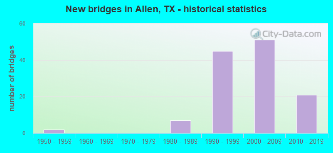
- New bridges - historical statistics
- 21950-1959
- 71980-1989
- 451990-1999
- 512000-2009
- 212010-2019
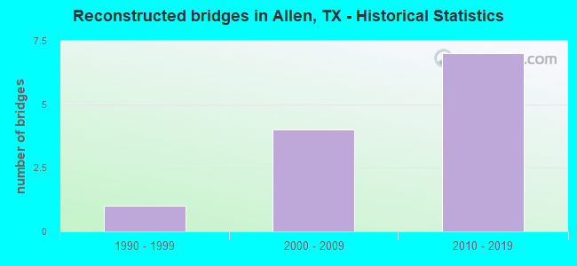
- Reconstructed bridges - Historical Statistics
- 11990-1999
- 42000-2009
- 72010-2019
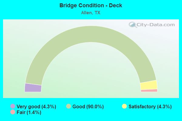
- Bridge Condition - Deck
- 4.3%Very good
- 90.0%Good
- 4.3%Satisfactory
- 1.4%Fair
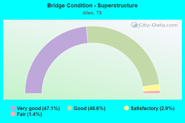
- Bridge Condition - Superstructure
- 47.1%Very good
- 48.6%Good
- 2.9%Satisfactory
- 1.4%Fair
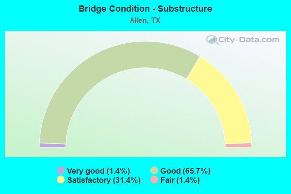
- Bridge Condition - Substructure
- 1.4%Very good
- 65.7%Good
- 31.4%Satisfactory
- 1.4%Fair
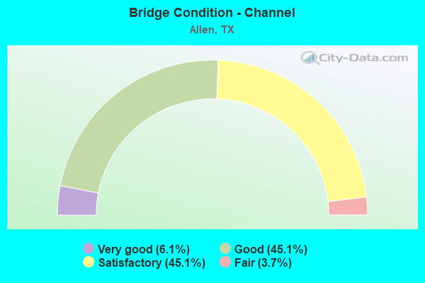
- Bridge Condition - Channel
- 6.1%Very good
- 45.1%Good
- 45.1%Satisfactory
- 3.7%Fair
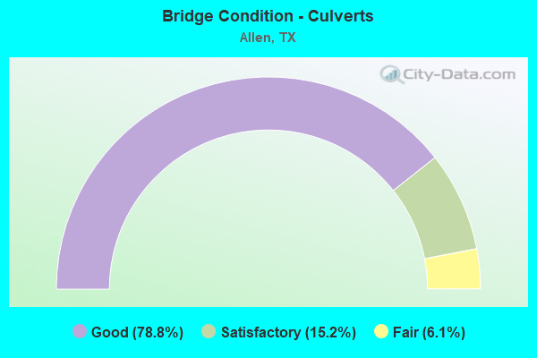
- Bridge Condition - Culverts
- 78.8%Good
- 15.2%Satisfactory
- 6.1%Fair
Find on map >> Show street view
Structure Number: 180430F00385003, Location: 0.8 MI W OF ALMA DR (Lat: 33.115672, Lng: -96.710628), Route carried "on" structure: City street , Year Built: 2009, Status: Open, Structure Length: 4.51m (14.80ft), Average Daily Traffic: 400 (year 2011), Average Future Daily Traffic: 1,000 (year 2031), Features Intersected: ROWLETT CREEK BRANCH, Facility Carried by Structure: EXCHANGE PKWY WB
Minimum Vertical Clearance: 30+ m (98+ ft), Kilometerpoint: 1.770, Lanes on structure: 2, Owner: City or Municipal Highway Agency, Approaching Roadway Width: 7.3m (24.0ft), Skew: 2 degrees, Material/Design: Prestressed concrete, Design/Construction: Stringer/Multi-beam, Number Of Spans In Main Unit: 1, Number Of Approach Spans: 1, Length of Maximum Span: 32.6m (107.0ft), Curb or Sidewalk Widths: Left: 3.0m (9.8ft), Right: 0.0m, Curb-To-Curb Width: 12.2m (40.0ft), Out-to-Out Width: 16.2m (53.1ft)
Condition: Deck: Good, Superstructure: Very good, Substructure: Good, Channel: Satisfactory, Operating Rating: 32.7 metric tons, Method Used To Determine Operating Rating: Field evaluation and documented engineering judgment, Inventory Rating: 24.5 metric tons, Method Used To Determine Inventory Rating: Field evaluation and documented engineering judgment, Structural Evaluation: Equal to present minimum criteria, Deck Geometry: Better than present minimum criteria, Waterway Adequacy: Superior to present desirable criteria, Approach Roadway Alignment: Equal to present desirable criteria, Designated Inspection Frequency: Every 24 months, Inspection Date: December 2020, Deck Structure Type: Concrete Precast Panels
Find on map >> Show street view
Structure Number: 180430F00390001, Location: 0.4 MI E OF N CEDAR DRIVE (Lat: 33.105811, Lng: -96.662647), Route carried "on" structure: City street , Year Built: 2007, Status: Open, Structure Length: 5.49m (18.01ft), Average Daily Traffic: 100 (year 2011), Average Future Daily Traffic: 200 (year 2031), Features Intersected: COTTONWOOD CREEK, Facility Carried by Structure: SAINT MARY DRIVE
Minimum Vertical Clearance: 30+ m (98+ ft), Kilometerpoint: 0.644, Lanes on structure: 2, Owner: City or Municipal Highway Agency, Approaching Roadway Width: 11.0m (36.1ft), Skew: 1 degrees, Material/Design: Prestressed concrete, Design/Construction: Stringer/Multi-beam, Number Of Spans In Main Unit: 1, Number Of Approach Spans: 2, Length of Maximum Span: 24.1m (79.1ft), Curb or Sidewalk Widths: Left: 1.9m (6.2ft), Right: 1.9m (6.2ft), Curb-To-Curb Width: 7.6m (24.9ft), Out-to-Out Width: 12.2m (40.0ft)
Condition: Deck: Good, Superstructure: Very good, Substructure: Good, Channel: Good, Operating Rating: 32.7 metric tons, Method Used To Determine Operating Rating: Field evaluation and documented engineering judgment, Inventory Rating: 24.5 metric tons, Method Used To Determine Inventory Rating: Field evaluation and documented engineering judgment, Structural Evaluation: Equal to present minimum criteria, Deck Geometry: Equal to present minimum criteria, Waterway Adequacy: Superior to present desirable criteria, Approach Roadway Alignment: Equal to present desirable criteria, Designated Inspection Frequency: Every 24 months, Inspection Date: January 2021, Deck Structure Type: Concrete Precast Panels
Find on map >> Show street view
Structure Number: 180430F00410001, Location: 0.50 MI W OF US 75 (Lat: 33.129853, Lng: -96.669533), Route carried "on" structure: City street 410, Year Built: 2001, Status: Open, Structure Length: 6.10m (20.01ft), Average Daily Traffic: 500 (year 2011), Truck Traffic: 7%, Average Future Daily Traffic: 720 (year 2031), Features Intersected: COTTONWOOD CREEK, Facility Carried by Structure: STACY RD WB
Minimum Vertical Clearance: 30+ m (98+ ft), Kilometerpoint: 0.805, Lanes on structure: 3, Owner: City or Municipal Highway Agency, Approaching Roadway Width: 12.2m (40.0ft), Skew: 3 degrees, Material/Design: Prestressed concrete, Design/Construction: Stringer/Multi-beam, Number Of Spans In Main Unit: 3, Length of Maximum Span: 24.4m (80.1ft), Curb or Sidewalk Widths: Left: 1.8m (5.9ft), Right: 0.0m, Curb-To-Curb Width: 12.2m (40.0ft), Out-to-Out Width: 14.9m (48.9ft)
Condition: Deck: Good, Superstructure: Good, Substructure: Satisfactory, Channel: Good, Operating Rating: 32.7 metric tons, Method Used To Determine Operating Rating: Field evaluation and documented engineering judgment, Inventory Rating: 24.5 metric tons, Method Used To Determine Inventory Rating: Field evaluation and documented engineering judgment, Structural Evaluation: Equal to present minimum criteria, Deck Geometry: Meets minimum limits, Waterway Adequacy: Equal to present minimum criteria, Approach Roadway Alignment: Equal to present desirable criteria, Designated Inspection Frequency: Every 24 months, Inspection Date: April 2021, Deck Structure Type: Concrete Precast Panels
Find on map >> Show street view
Structure Number: 180430F00410002, Location: 0.50 MI W OF US 75 (Lat: 33.129683, Lng: -96.669564), Route carried "on" structure: City street 410, Year Built: 2001, Status: Open, Structure Length: 6.10m (20.01ft), Average Daily Traffic: 500 (year 2011), Truck Traffic: 7%, Average Future Daily Traffic: 720 (year 2031), Features Intersected: COTTONWOOD CREEK, Facility Carried by Structure: STACY RD EB
Minimum Vertical Clearance: 30+ m (98+ ft), Kilometerpoint: 0.805, Lanes on structure: 3, Owner: City or Municipal Highway Agency, Approaching Roadway Width: 12.2m (40.0ft), Skew: 3 degrees, Material/Design: Prestressed concrete, Design/Construction: Stringer/Multi-beam, Number Of Spans In Main Unit: 3, Length of Maximum Span: 24.4m (80.1ft), Curb or Sidewalk Widths: Left: 0.0m, Right: 1.8m (5.9ft), Curb-To-Curb Width: 12.2m (40.0ft), Out-to-Out Width: 14.9m (48.9ft)
Condition: Deck: Good, Superstructure: Very good, Substructure: Satisfactory, Channel: Good, Operating Rating: 32.7 metric tons, Method Used To Determine Operating Rating: Field evaluation and documented engineering judgment, Inventory Rating: 24.5 metric tons, Method Used To Determine Inventory Rating: Field evaluation and documented engineering judgment, Structural Evaluation: Equal to present minimum criteria, Deck Geometry: Meets minimum limits, Waterway Adequacy: Equal to present minimum criteria, Approach Roadway Alignment: Equal to present desirable criteria, Designated Inspection Frequency: Every 24 months, Inspection Date: April 2021, Deck Structure Type: Concrete Precast Panels
Find on map >> Show street view
Structure Number: 180430F00416001, Location: 0.20 MI W OF CEDAR DR (Lat: 33.113333, Lng: -96.661464), Route carried "on" structure: City street , Year Built: 1997, Status: Open, Structure Length: 1.83m (6.00ft), Average Daily Traffic: 50 (year 2011), Average Future Daily Traffic: 330 (year 2031), Features Intersected: COTTONWOOD CREEK TRIB, Facility Carried by Structure: STATION PARK DR
Minimum Vertical Clearance: 30+ m (98+ ft), Kilometerpoint: 0.322, Lanes on structure: 2, Owner: City or Municipal Highway Agency, Approaching Roadway Width: 7.9m (25.9ft), Skew: 1 degrees, Material/Design: Prestressed concrete, Design/Construction: Stringer/Multi-beam, Number Of Spans In Main Unit: 1, Length of Maximum Span: 17.7m (58.1ft), Curb-To-Curb Width: 10.5m (34.4ft), Out-to-Out Width: 11.2m (36.7ft)
Condition: Deck: Good, Superstructure: Very good, Substructure: Good, Channel: Satisfactory, Operating Rating: 32.7 metric tons, Method Used To Determine Operating Rating: Field evaluation and documented engineering judgment, Inventory Rating: 24.5 metric tons, Method Used To Determine Inventory Rating: Field evaluation and documented engineering judgment, Structural Evaluation: Equal to present minimum criteria, Deck Geometry: Superior to present desirable criteria, Waterway Adequacy: Better than present minimum criteria, Approach Roadway Alignment: Equal to present desirable criteria, Designated Inspection Frequency: Every 24 months, Inspection Date: Febuary 2021, Deck Structure Type: Concrete Precast Panels
Find on map >> Show street view
Structure Number: 180430F00432001, Location: 0.05 MI W OF ALLEN HGTS (Lat: 33.106069, Lng: -96.641167), Route carried "on" structure: City street , Year Built: 1998, Status: Open, Structure Length: 1.16m (3.81ft), Average Daily Traffic: 800 (year 2011), Average Future Daily Traffic: 1,280 (year 2031), Features Intersected: DRAW, Facility Carried by Structure: TIMBER CREEK DR
Minimum Vertical Clearance: 30+ m (98+ ft), Kilometerpoint: 0.002, Lanes on structure: 2, Owner: City or Municipal Highway Agency, Approaching Roadway Width: 8.8m (28.9ft), Material/Design: Concrete, Design/Construction: Culvert, Number Of Spans In Main Unit: 4, Length of Maximum Span: 2.4m (7.9ft), Curb or Sidewalk Widths: Left: 1.2m (3.9ft), Right: 1.2m (3.9ft), Curb-To-Curb Width: 9.0m (29.5ft), Out-to-Out Width: 20.1m (65.9ft)
Condition: Channel: Good, Culverts: Good, Operating Rating: 32.7 metric tons, Method Used To Determine Operating Rating: Field evaluation and documented engineering judgment, Inventory Rating: 24.5 metric tons, Method Used To Determine Inventory Rating: Field evaluation and documented engineering judgment, Structural Evaluation: Equal to present minimum criteria, Deck Geometry: Somewhat better than minimum adequacy, Waterway Adequacy: Better than present minimum criteria, Approach Roadway Alignment: Equal to present desirable criteria, Designated Inspection Frequency: Every 24 months, Inspection Date: Febuary 2021, Deck Structure Type: Concrete Cast-file-Place, Wearing Surface/Protective System: Wearing Surface: Monolithic Concrete
Find on map >> Show street view
Structure Number: 180430F00452001, Location: 0.30 MI S OF SH 121 (Lat: 33.140733, Lng: -96.676786), Route carried "on" structure: City street , Year Built: 2005, Status: Open, Structure Length: 1.34m (4.40ft), Average Daily Traffic: 4,000 (year 2011), Truck Traffic: 1%, Average Future Daily Traffic: 10,000 (year 2031), Features Intersected: COTTONWOOD CREEK TRIB, Facility Carried by Structure: WATTERS RD
Minimum Vertical Clearance: 30+ m (98+ ft), Kilometerpoint: 0.483, Lanes on structure: 6, Owner: City or Municipal Highway Agency, Approaching Roadway Width: 21.3m (69.9ft), Skew: 22 degrees, Material/Design: Concrete, Design/Construction: Culvert, Number Of Spans In Main Unit: 4, Length of Maximum Span: 3.0m (9.8ft)
Condition: Channel: Satisfactory, Culverts: Good, Operating Rating: 32.7 metric tons, Method Used To Determine Operating Rating: Field evaluation and documented engineering judgment, Inventory Rating: 24.5 metric tons, Method Used To Determine Inventory Rating: Field evaluation and documented engineering judgment, Structural Evaluation: Equal to present minimum criteria, Waterway Adequacy: Better than present minimum criteria, Approach Roadway Alignment: Equal to present desirable criteria, Designated Inspection Frequency: Every 24 months, Inspection Date: April 2021
Find on map >> Show street view
Structure Number: 180430F00452002, Location: 0.10 MI S OF STACY RD (Lat: 33.128583, Lng: -96.676822), Route carried "on" structure: City street , Year Built: 2005, Year Reconstructed: 2010, Status: Open, Structure Length: 0.64m (2.10ft), Average Daily Traffic: 11,789 (year 2019), Truck Traffic: 1%, Average Future Daily Traffic: 10,000 (year 2031), Features Intersected: COTTONWOOD CREEK TRIB, Facility Carried by Structure: WATTERS RD
Minimum Vertical Clearance: 30+ m (98+ ft), Kilometerpoint: 0.161, Lanes on structure: 5, Owner: City or Municipal Highway Agency, Approaching Roadway Width: 17.7m (58.1ft), Skew: 1 degrees, Material/Design: Concrete, Design/Construction: Culvert, Number Of Spans In Main Unit: 4, Length of Maximum Span: 1.2m (3.9ft), Curb or Sidewalk Widths: Left: 1.5m (4.9ft), Right: 1.5m (4.9ft)
Condition: Channel: Very good, Culverts: Satisfactory, Operating Rating: 32.7 metric tons, Method Used To Determine Operating Rating: Field evaluation and documented engineering judgment, Inventory Rating: 24.5 metric tons, Method Used To Determine Inventory Rating: Field evaluation and documented engineering judgment, Structural Evaluation: Equal to present minimum criteria, Waterway Adequacy: Better than present minimum criteria, Approach Roadway Alignment: Equal to present desirable criteria, Designated Inspection Frequency: Every 24 months, Inspection Date: April 2021
Find on map >> Show street view
Structure Number: 180430F00452003, Location: 0.40 MI E OF N WATTERS RD (Lat: 33.143511, Lng: -96.671381), Route carried "on" structure: City street , Year Built: 2018, Status: Open, Structure Length: 6.92m (22.70ft), Average Daily Traffic: 1,063 (year 2018), Truck Traffic: 3%, Average Future Daily Traffic: 1,488 (year 2038), Features Intersected: COTTONWOOD CREEK, Facility Carried by Structure: RIDGEVIEW DR
Minimum Vertical Clearance: 30+ m (98+ ft), Kilometerpoint: 0.644, Lanes on structure: 4, Owner: City or Municipal Highway Agency, Approaching Roadway Width: 14.6m (47.9ft), Skew: 31 degrees, Material/Design: Prestressed concrete, Design/Construction: Stringer/Multi-beam, Number Of Spans In Main Unit: 3, Length of Maximum Span: 29.0m (95.1ft), Curb or Sidewalk Widths: Left: 4.3m (14.1ft), Right: 3.0m (9.8ft), Curb-To-Curb Width: 24.1m (79.1ft), Out-to-Out Width: 33.2m (108.9ft)
Condition: Deck: Good, Superstructure: Very good, Substructure: Good, Channel: Good, Operating Rating: 32.7 metric tons, Method Used To Determine Operating Rating: Field evaluation and documented engineering judgment, Inventory Rating: 24.5 metric tons, Method Used To Determine Inventory Rating: Field evaluation and documented engineering judgment, Structural Evaluation: Equal to present minimum criteria, Deck Geometry: Superior to present desirable criteria, Waterway Adequacy: Equal to present minimum criteria, Approach Roadway Alignment: Equal to present desirable criteria, Designated Inspection Frequency: Every 24 months, Inspection Date: July 2020, Deck Structure Type: Concrete Cast-file-Place
Find on map >> Show street view
Structure Number: 180430F00452004, Location: 0.70 MI N OF STACY RD (Lat: 33.138669, Lng: -96.670961), Route carried "on" structure: City street , Year Built: 2013, Status: Open, Structure Length: 6.13m (20.11ft), Average Daily Traffic: 230 (year 2018), Truck Traffic: 3%, Average Future Daily Traffic: 345 (year 2038), Design Load: HL 93, Features Intersected: COTTONWOOD CREEK, Facility Carried by Structure: STARCREEK PKWY
Minimum Vertical Clearance: 30+ m (98+ ft), Kilometerpoint: 1.127, Lanes on structure: 2, Owner: City or Municipal Highway Agency, Approaching Roadway Width: 7.9m (25.9ft), Material/Design: Prestressed concrete, Design/Construction: Stringer/Multi-beam, Number Of Spans In Main Unit: 3, Length of Maximum Span: 20.4m (66.9ft), Curb or Sidewalk Widths: Left: 1.3m (4.3ft), Right: 3.0m (9.8ft), Curb-To-Curb Width: 7.9m (25.9ft), Out-to-Out Width: 13.0m (42.7ft)
Condition: Deck: Good, Superstructure: Very good, Substructure: Very good, Channel: Good, Operating Rating: 54.4 metric tons, Method Used To Determine Operating Rating: Assigned ratings based on Load and Resistance Factor Design (LRFD) reported in metric tons, Inventory Rating: 32.7 metric tons, Method Used To Determine Inventory Rating: Assigned ratings based on Load and Resistance Factor Design (LRFD) reported in metric tons, Structural Evaluation: Equal to present desirable criteria, Deck Geometry: Somewhat better than minimum adequacy, Waterway Adequacy: Superior to present desirable criteria, Approach Roadway Alignment: Equal to present desirable criteria, Designated Inspection Frequency: Every 24 months, Inspection Date: July 2020, Deck Structure Type: Concrete Cast-file-Place
Find on map >> Show street view
Structure Number: 180430F00452005, Location: 0.40 MI N OF W EXCHANGE (Lat: 33.120519, Lng: -96.686811), Route carried "on" structure: City street , Year Built: 2007, Year Reconstructed: 2014, Status: Open, Structure Length: 0.82m (2.69ft), Average Daily Traffic: 500 (year 2018), Truck Traffic: 3%, Average Future Daily Traffic: 750 (year 2038), Features Intersected: TRIB WATTERS CREEK, Facility Carried by Structure: BRAY CENTRAL DR
Minimum Vertical Clearance: 30+ m (98+ ft), Kilometerpoint: 0.644, Lanes on structure: 4, Owner: City or Municipal Highway Agency, Approaching Roadway Width: 14.6m (47.9ft), Skew: 20 degrees, Material/Design: Concrete, Design/Construction: Culvert, Number Of Spans In Main Unit: 4, Length of Maximum Span: 1.8m (5.9ft), Curb or Sidewalk Widths: Left: 0.0m, Right: 1.5m (4.9ft), Curb-To-Curb Width: 14.6m (47.9ft), Out-to-Out Width: 28.9m (94.8ft)
Condition: Channel: Good, Culverts: Good, Operating Rating: 32.7 metric tons, Method Used To Determine Operating Rating: Field evaluation and documented engineering judgment, Inventory Rating: 24.5 metric tons, Method Used To Determine Inventory Rating: Field evaluation and documented engineering judgment, Structural Evaluation: Equal to present minimum criteria, Deck Geometry: High priority of replacement, Waterway Adequacy: Equal to present minimum criteria, Approach Roadway Alignment: Equal to present desirable criteria, Designated Inspection Frequency: Every 24 months, Inspection Date: July 2020, Deck Structure Type: Concrete Cast-file-Place, Wearing Surface/Protective System: Wearing Surface: Monolithic Concrete
Find on map >> Show street view
Structure Number: 180430F00452006, Location: 0.60 MI SW OF STACY RD (Lat: 33.130300, Lng: -96.696350), Route carried "on" structure: City street , Year Built: 2016, Status: Open, Structure Length: 3.87m (12.70ft), Average Daily Traffic: 1,063 (year 2018), Truck Traffic: 3%, Average Future Daily Traffic: 1,488 (year 2038), Features Intersected: WATTERS CREEK, Facility Carried by Structure: RIDGEVIEW DR
Minimum Vertical Clearance: 30+ m (98+ ft), Kilometerpoint: 0.966, Lanes on structure: 3, Owner: City or Municipal Highway Agency, Approaching Roadway Width: 14.6m (47.9ft), Skew: 32 degrees, Material/Design: Prestressed concrete, Design/Construction: Stringer/Multi-beam, Number Of Spans In Main Unit: 1, Length of Maximum Span: 38.1m (125.0ft), Curb or Sidewalk Widths: Left: 4.3m (14.1ft), Right: 3.0m (9.8ft), Curb-To-Curb Width: 24.1m (79.1ft), Out-to-Out Width: 33.2m (108.9ft)
Condition: Deck: Good, Superstructure: Very good, Substructure: Good, Channel: Good, Operating Rating: 32.7 metric tons, Method Used To Determine Operating Rating: Field evaluation and documented engineering judgment, Inventory Rating: 24.5 metric tons, Method Used To Determine Inventory Rating: Field evaluation and documented engineering judgment, Structural Evaluation: Equal to present minimum criteria, Deck Geometry: Superior to present desirable criteria, Waterway Adequacy: Equal to present minimum criteria, Approach Roadway Alignment: Equal to present desirable criteria, Designated Inspection Frequency: Every 24 months, Inspection Date: July 2020, Deck Structure Type: Concrete Cast-file-Place
Find on map >> Show street view
Structure Number: 180430F00453001, Location: 0.40 MI S OF MCDERMOTT (Lat: 33.095539, Lng: -96.685272), Route carried "on" structure: City street , Year Built: 1998, Status: Open, Structure Length: 0.79m (2.59ft), Average Daily Traffic: 10,637 (year 2018), Truck Traffic: 3%, Average Future Daily Traffic: 14,892 (year 2038), Features Intersected: TRIB WATTERS CREEK, Facility Carried by Structure: S WATTERS RD
Minimum Vertical Clearance: 30+ m (98+ ft), Kilometerpoint: 0.644, Lanes on structure: 4, Owner: City or Municipal Highway Agency, Approaching Roadway Width: 14.6m (47.9ft), Skew: 20 degrees, Material/Design: Concrete, Design/Construction: Culvert, Number Of Spans In Main Unit: 3, Length of Maximum Span: 2.4m (7.9ft), Curb or Sidewalk Widths: Left: 0.0m, Right: 1.4m (4.6ft), Curb-To-Curb Width: 14.6m (47.9ft), Out-to-Out Width: 55.7m (182.7ft)
Condition: Channel: Satisfactory, Culverts: Good, Operating Rating: 32.7 metric tons, Method Used To Determine Operating Rating: Field evaluation and documented engineering judgment, Inventory Rating: 24.5 metric tons, Method Used To Determine Inventory Rating: Field evaluation and documented engineering judgment, Structural Evaluation: Equal to present minimum criteria, Deck Geometry: High priority of replacement, Waterway Adequacy: Equal to present minimum criteria, Approach Roadway Alignment: Equal to present desirable criteria, Designated Inspection Frequency: Every 24 months, Inspection Date: August 2020, Deck Structure Type: Concrete Cast-file-Place, Wearing Surface/Protective System: Wearing Surface: Monolithic Concrete
Find on map >> Show street view
Structure Number: 180430F02502001, Location: 0.10 MI W OF N WATTERS RD (Lat: 33.111208, Lng: -96.683011), Route carried "on" structure: City street , Year Built: 2015, Year Reconstructed: 2019, Status: Open, Structure Length: 1.01m (3.31ft), Average Daily Traffic: 163 (year 2019), Truck Traffic: 3%, Average Future Daily Traffic: 163 (year 2039), Features Intersected: DRAW, Facility Carried by Structure: KENNEDY DR
Minimum Vertical Clearance: 30+ m (98+ ft), Kilometerpoint: 0.161, Lanes on structure: 2, Owner: City or Municipal Highway Agency, Approaching Roadway Width: 7.3m (24.0ft), Material/Design: Concrete, Design/Construction: Culvert, Number Of Spans In Main Unit: 3, Length of Maximum Span: 2.7m (8.9ft), Curb or Sidewalk Widths: Left: 1.5m (4.9ft), Right: 3.0m (9.8ft)
Condition: Channel: Good, Culverts: Good, Operating Rating: 32.7 metric tons, Method Used To Determine Operating Rating: Field evaluation and documented engineering judgment, Inventory Rating: 24.5 metric tons, Method Used To Determine Inventory Rating: Field evaluation and documented engineering judgment, Structural Evaluation: Equal to present minimum criteria, Waterway Adequacy: Better than present minimum criteria, Approach Roadway Alignment: Equal to present desirable criteria, Designated Inspection Frequency: Every 24 months, Inspection Date: October 2020
Find on map >> Show street view
Structure Number: 180430LA2507001, Location: 0.40 MI N OF MCDERMOTT (Lat: 33.106625, Lng: -96.687481), Route carried "on" structure: City street , Year Built: 2003, Status: Open, Structure Length: 1.59m (5.22ft), Average Daily Traffic: 230 (year 2018), Truck Traffic: 3%, Average Future Daily Traffic: 345 (year 2038), Features Intersected: TRIB WATTERS CREEK, Facility Carried by Structure: BENTON DR
Minimum Vertical Clearance: 30+ m (98+ ft), Kilometerpoint: 0.644, Lanes on structure: 4, Owner: City or Municipal Highway Agency, Approaching Roadway Width: 14.6m (47.9ft), Material/Design: Concrete, Design/Construction: Culvert, Number Of Spans In Main Unit: 6, Length of Maximum Span: 2.4m (7.9ft), Curb or Sidewalk Widths: Left: 3.0m (9.8ft), Right: 1.2m (3.9ft), Curb-To-Curb Width: 14.6m (47.9ft), Out-to-Out Width: 27.4m (89.9ft)
Condition: Channel: Good, Culverts: Good, Operating Rating: 32.7 metric tons, Method Used To Determine Operating Rating: Field evaluation and documented engineering judgment, Inventory Rating: 24.5 metric tons, Method Used To Determine Inventory Rating: Field evaluation and documented engineering judgment, Structural Evaluation: Equal to present minimum criteria, Deck Geometry: High priority of replacement, Waterway Adequacy: Better than present minimum criteria, Approach Roadway Alignment: Equal to present desirable criteria, Designated Inspection Frequency: Every 24 months, Inspection Date: August 2020, Deck Structure Type: Concrete Cast-file-Place, Wearing Surface/Protective System: Wearing Surface: Monolithic Concrete
Find on map >> Show street view
Structure Number: 180430LA2583001, Location: 0.10 MI W OF FM 2551 (Lat: 33.082492, Lng: -96.622150), Route carried "on" structure: City street , Year Built: 1998, Status: Open, Structure Length: 0.91m (2.99ft), Average Daily Traffic: 230 (year 2018), Truck Traffic: 3%, Average Future Daily Traffic: 345 (year 2038), Features Intersected: MAXWELL CREEK, Facility Carried by Structure: BUR OAK DR
Minimum Vertical Clearance: 30+ m (98+ ft), Kilometerpoint: 0.161, Lanes on structure: 2, Owner: City or Municipal Highway Agency, Approaching Roadway Width: 11.0m (36.1ft), Material/Design: Concrete, Design/Construction: Culvert, Number Of Spans In Main Unit: 4, Length of Maximum Span: 1.8m (5.9ft), Curb or Sidewalk Widths: Left: 1.2m (3.9ft), Right: 1.2m (3.9ft), Curb-To-Curb Width: 11.0m (36.1ft), Out-to-Out Width: 23.2m (76.1ft)
Condition: Channel: Very good, Culverts: Good, Operating Rating: 32.7 metric tons, Method Used To Determine Operating Rating: Field evaluation and documented engineering judgment, Inventory Rating: 24.5 metric tons, Method Used To Determine Inventory Rating: Field evaluation and documented engineering judgment, Structural Evaluation: Equal to present minimum criteria, Deck Geometry: Equal to present desirable criteria, Waterway Adequacy: Better than present minimum criteria, Approach Roadway Alignment: Equal to present desirable criteria, Designated Inspection Frequency: Every 24 months, Inspection Date: August 2020, Deck Structure Type: Concrete Cast-file-Place, Wearing Surface/Protective System: Wearing Surface: Monolithic Concrete
Find on map >> Show street view
Structure Number: 180430LA2640001, Location: 0.20 MI W OF FM 2551 (Lat: 33.076528, Lng: -96.623222), Route carried "on" structure: City street , Year Built: 2007, Status: Open, Structure Length: 0.82m (2.69ft), Average Daily Traffic: 230 (year 2018), Truck Traffic: 3%, Average Future Daily Traffic: 345 (year 2038), Features Intersected: MAXWELL CREEK, Facility Carried by Structure: CHAPARRAL DR
Minimum Vertical Clearance: 30+ m (98+ ft), Kilometerpoint: 0.322, Lanes on structure: 4, Owner: City or Municipal Highway Agency, Approaching Roadway Width: 14.6m (47.9ft), Skew: 21 degrees, Material/Design: Concrete, Design/Construction: Culvert, Number Of Spans In Main Unit: 3, Length of Maximum Span: 2.4m (7.9ft), Curb or Sidewalk Widths: Left: 2.7m (8.9ft), Right: 1.5m (4.9ft), Curb-To-Curb Width: 14.6m (47.9ft), Out-to-Out Width: 35.4m (116.1ft)
Condition: Channel: Very good, Culverts: Good, Operating Rating: 32.7 metric tons, Method Used To Determine Operating Rating: Field evaluation and documented engineering judgment, Inventory Rating: 24.5 metric tons, Method Used To Determine Inventory Rating: Field evaluation and documented engineering judgment, Structural Evaluation: Equal to present minimum criteria, Deck Geometry: High priority of replacement, Waterway Adequacy: Better than present minimum criteria, Approach Roadway Alignment: Equal to present desirable criteria, Designated Inspection Frequency: Every 24 months, Inspection Date: August 2020, Deck Structure Type: Concrete Cast-file-Place, Wearing Surface/Protective System: Wearing Surface: Monolithic Concrete
Find on map >> Show street view
Structure Number: 180430LA3156001, Location: 0.03 MI E OF WATER OAK DR (Lat: 33.084150, Lng: -96.622392), Route carried "on" structure: City street , Year Built: 2000, Status: Open, Structure Length: 0.91m (2.99ft), Average Daily Traffic: 230 (year 2018), Truck Traffic: 3%, Average Future Daily Traffic: 345 (year 2038), Features Intersected: MAXWELL CREEK, Facility Carried by Structure: MOUNTAIN LAUREL LN
Minimum Vertical Clearance: 30+ m (98+ ft), Kilometerpoint: 0.048, Lanes on structure: 2, Owner: City or Municipal Highway Agency, Approaching Roadway Width: 9.1m (29.9ft), Material/Design: Concrete, Design/Construction: Culvert, Number Of Spans In Main Unit: 4, Length of Maximum Span: 1.8m (5.9ft), Curb or Sidewalk Widths: Left: 1.2m (3.9ft), Right: 1.2m (3.9ft), Curb-To-Curb Width: 9.1m (29.9ft), Out-to-Out Width: 20.0m (65.6ft)
Condition: Channel: Very good, Culverts: Good, Operating Rating: 32.7 metric tons, Method Used To Determine Operating Rating: Field evaluation and documented engineering judgment, Inventory Rating: 24.5 metric tons, Method Used To Determine Inventory Rating: Field evaluation and documented engineering judgment, Structural Evaluation: Equal to present minimum criteria, Deck Geometry: Equal to present minimum criteria, Waterway Adequacy: Better than present minimum criteria, Approach Roadway Alignment: Equal to present desirable criteria, Designated Inspection Frequency: Every 24 months, Inspection Date: August 2020, Deck Structure Type: Concrete Cast-file-Place, Wearing Surface/Protective System: Wearing Surface: Monolithic Concrete
Find on map >> Show street view
Structure Number: 180430LA3394001, Location: 0.01 MI S OF PINE BLUFF (Lat: 33.090789, Lng: -96.635403), Route carried "on" structure: City street , Year Built: 1997, Status: Open, Structure Length: 0.70m (2.30ft), Average Daily Traffic: 230 (year 2018), Truck Traffic: 3%, Average Future Daily Traffic: 345 (year 2038), Features Intersected: DRAW, Facility Carried by Structure: SEMINOLE TR
Minimum Vertical Clearance: 30+ m (98+ ft), Kilometerpoint: 0.016, Lanes on structure: 2, Owner: City or Municipal Highway Agency, Approaching Roadway Width: 9.1m (29.9ft), Skew: 1 degrees, Material/Design: Concrete, Design/Construction: Culvert, Number Of Spans In Main Unit: 3, Length of Maximum Span: 1.8m (5.9ft), Curb or Sidewalk Widths: Left: 1.2m (3.9ft), Right: 1.2m (3.9ft), Curb-To-Curb Width: 9.1m (29.9ft), Out-to-Out Width: 15.6m (51.2ft)
Condition: Channel: Satisfactory, Culverts: Good, Operating Rating: 32.7 metric tons, Method Used To Determine Operating Rating: Field evaluation and documented engineering judgment, Inventory Rating: 24.5 metric tons, Method Used To Determine Inventory Rating: Field evaluation and documented engineering judgment, Structural Evaluation: Equal to present minimum criteria, Deck Geometry: Equal to present minimum criteria, Waterway Adequacy: Better than present minimum criteria, Approach Roadway Alignment: Equal to present desirable criteria, Designated Inspection Frequency: Every 24 months, Inspection Date: August 2020, Deck Structure Type: Concrete Cast-file-Place, Wearing Surface/Protective System: Wearing Surface: Monolithic Concrete
Find on map >> Show street view
Structure Number: 180430LA3408001, Location: 0.20 MI W OF FM 2551 (Lat: 33.079719, Lng: -96.623006), Route carried "on" structure: City street , Year Built: 2000, Status: Open, Structure Length: 0.82m (2.69ft), Average Daily Traffic: 163 (year 2019), Truck Traffic: 3%, Average Future Daily Traffic: 163 (year 2039), Design Load: HS 20, Features Intersected: MAXWELL CREEK, Facility Carried by Structure: SHELLEY DR
Minimum Vertical Clearance: 30+ m (98+ ft), Kilometerpoint: 0.322, Lanes on structure: 4, Owner: City or Municipal Highway Agency, Approaching Roadway Width: 21.9m (71.9ft), Skew: 9 degrees, Material/Design: Concrete, Design/Construction: Culvert, Number Of Spans In Main Unit: 4, Length of Maximum Span: 1.8m (5.9ft), Curb or Sidewalk Widths: Left: 1.2m (3.9ft), Right: 2.4m (7.9ft)
Condition: Channel: Satisfactory, Culverts: Satisfactory, Operating Rating: 44.4 metric tons, Method Used To Determine Operating Rating: No rating analysis performed, Inventory Rating: 32.7 metric tons, Method Used To Determine Inventory Rating: No rating analysis performed, Structural Evaluation: Equal to present minimum criteria, Waterway Adequacy: Better than present minimum criteria, Approach Roadway Alignment: Equal to present desirable criteria, Designated Inspection Frequency: Every 24 months, Inspection Date: October 2020
Find on map >> Show street view
Structure Number: 180430LA3679001, Location: 0.04 MI W OF SHALLOWATER (Lat: 33.102247, Lng: -96.726833), Route carried "on" structure: City street , Year Built: 2011, Status: Open, Structure Length: 0.67m (2.20ft), Average Daily Traffic: 163 (year 2019), Truck Traffic: 3%, Average Future Daily Traffic: 163 (year 2039), Features Intersected: TRIB ROWLETT CREEK, Facility Carried by Structure: WOODLAND POND DR
Minimum Vertical Clearance: 30+ m (98+ ft), Kilometerpoint: 0.064, Lanes on structure: 2, Owner: City or Municipal Highway Agency, Approaching Roadway Width: 9.1m (29.9ft), Material/Design: Concrete, Design/Construction: Culvert, Number Of Spans In Main Unit: 2, Length of Maximum Span: 3.0m (9.8ft), Curb or Sidewalk Widths: Left: 1.8m (5.9ft), Right: 1.2m (3.9ft), Curb-To-Curb Width: 9.1m (29.9ft), Out-to-Out Width: 23.6m (77.4ft)
Condition: Channel: Good, Culverts: Good, Operating Rating: 32.7 metric tons, Method Used To Determine Operating Rating: Field evaluation and documented engineering judgment, Inventory Rating: 24.5 metric tons, Method Used To Determine Inventory Rating: Field evaluation and documented engineering judgment, Structural Evaluation: Equal to present minimum criteria, Deck Geometry: Equal to present minimum criteria, Waterway Adequacy: Superior to present desirable criteria, Approach Roadway Alignment: Equal to present desirable criteria, Designated Inspection Frequency: Every 24 months, Inspection Date: October 2020, Deck Structure Type: Concrete Cast-file-Place, Wearing Surface/Protective System: Wearing Surface: Monolithic Concrete
Find on map >> Show street view
Structure Number: 180430T01218001, Location: 0.08 MI N OF W MCDERMOTT (Lat: 33.101956, Lng: -96.727567), Route carried "on" structure: City street , Year Built: 2011, Status: Open, Structure Length: 0.67m (2.20ft), Average Daily Traffic: 2,923 (year 2019), Truck Traffic: 4%, Average Future Daily Traffic: 4,092 (year 2039), Features Intersected: TRIB ROWLETT CREEK, Facility Carried by Structure: SHALLOWATER DR
Minimum Vertical Clearance: 30+ m (98+ ft), Kilometerpoint: 0.122, Lanes on structure: 2, Owner: City or Municipal Highway Agency, Approaching Roadway Width: 7.3m (24.0ft), Material/Design: Concrete, Design/Construction: Culvert, Number Of Spans In Main Unit: 2, Length of Maximum Span: 3.0m (9.8ft), Curb or Sidewalk Widths: Left: 1.2m (3.9ft), Right: 0.0m, Curb-To-Curb Width: 7.3m (24.0ft), Out-to-Out Width: 18.3m (60.0ft)
Condition: Channel: Good, Culverts: Good, Operating Rating: 32.7 metric tons, Method Used To Determine Operating Rating: Field evaluation and documented engineering judgment, Inventory Rating: 24.5 metric tons, Method Used To Determine Inventory Rating: Field evaluation and documented engineering judgment, Structural Evaluation: Equal to present minimum criteria, Deck Geometry: High priority of replacement, Waterway Adequacy: Superior to present desirable criteria, Approach Roadway Alignment: Equal to present desirable criteria, Designated Inspection Frequency: Every 24 months, Inspection Date: October 2020, Deck Structure Type: Concrete Cast-file-Place, Wearing Surface/Protective System: Wearing Surface: Monolithic Concrete
Find on map >> Show street view
Structure Number: 180430T01363001, Location: 0.50 MI S OF EXCHANGE PKY (Lat: 33.107583, Lng: -96.686400), Route carried "on" structure: City street , Year Built: 2003, Status: Open, Structure Length: 1.59m (5.22ft), Average Daily Traffic: 500 (year 2018), Truck Traffic: 3%, Average Future Daily Traffic: 750 (year 2038), Features Intersected: TRIB WATTERS CREEK, Facility Carried by Structure: BRAY CENTRAL DR
Minimum Vertical Clearance: 30+ m (98+ ft), Kilometerpoint: 0.805, Lanes on structure: 4, Owner: City or Municipal Highway Agency, Approaching Roadway Width: 14.6m (47.9ft), Skew: 20 degrees, Material/Design: Concrete, Design/Construction: Culvert, Number Of Spans In Main Unit: 6, Length of Maximum Span: 2.4m (7.9ft), Curb or Sidewalk Widths: Left: 1.5m (4.9ft), Right: 3.0m (9.8ft), Curb-To-Curb Width: 14.6m (47.9ft), Out-to-Out Width: 33.5m (109.9ft)
Condition: Channel: Good, Culverts: Good, Operating Rating: 32.7 metric tons, Method Used To Determine Operating Rating: Field evaluation and documented engineering judgment, Inventory Rating: 24.5 metric tons, Method Used To Determine Inventory Rating: Field evaluation and documented engineering judgment, Structural Evaluation: Equal to present minimum criteria, Deck Geometry: High priority of replacement, Waterway Adequacy: Equal to present minimum criteria, Approach Roadway Alignment: Equal to present desirable criteria, Designated Inspection Frequency: Every 24 months, Inspection Date: August 2020, Deck Structure Type: Concrete Cast-file-Place, Wearing Surface/Protective System: Wearing Surface: Monolithic Concrete
Find on map >> Show street view
Structure Number: 180430004706102, Location: 1.10 MI N OF FM 2786 (Lat: 33.144081, Lng: -96.651222), Route carried "under" structure: US 75, Year Built: 1957, Structure Length: 0. m, Average Daily Traffic: 127,355 (year 2018), Truck Traffic: 7%, Features Intersected: US 75, Facility Carried by Structure: RIDGEVIEW DR
Minimum Vertical Clearance: 5.36m (17.59ft), Kilometerpoint: 4.688, Lanes on structure: 2, Lanes under structure: 12, Material/Design: Steel continuous, Design/Construction: Stringer/Multi-beam, Length of Maximum Span: 19.8m (65.0ft)
Find on map >> Show street view
Structure Number: 180430004706302, Location: 0.80 MI S OF FM 2170 (Lat: 33.090722, Lng: -96.681197), Route carried "under" structure: Alternate City street , Year Built: 1992, Structure Length: 0. m, Average Daily Traffic: 21,346 (year 2018), Truck Traffic: 3%, Features Intersected: BETHANY DRIVE, Facility Carried by Structure: US 75 NB
Minimum Vertical Clearance: 5.33m (17.49ft), Kilometerpoint: 7.582, Lanes on structure: 5, Lanes under structure: 6, Material/Design: Prestressed concrete, Design/Construction: Stringer/Multi-beam, Length of Maximum Span: 32.0m (105.0ft)
Find on map >> Show street view
Structure Number: 180430004706303, Location: 0.80 MI S OF FM 2170 (Lat: 33.090633, Lng: -96.681500), Route carried "under" structure: Alternate City street , Year Built: 1992, Structure Length: 0. m, Average Daily Traffic: 21,346 (year 2018), Truck Traffic: 3%, Features Intersected: BETHANY DRIVE, Facility Carried by Structure: US 75 SB
Minimum Vertical Clearance: 5.28m (17.32ft), Kilometerpoint: 7.582, Lanes on structure: 5, Lanes under structure: 6, Material/Design: Prestressed concrete, Design/Construction: Stringer/Multi-beam, Length of Maximum Span: 32.0m (105.0ft)
Find on map >> Show street view
Structure Number: 1804300047064, Location: AT INT OF US 75 & FM 2170 (Lat: 33.102256, Lng: -96.677567), Route carried "under" structure: State highway 2710, Year Built: 1999, Structure Length: 0. m, Average Daily Traffic: 38,486 (year 2018), Truck Traffic: 3%, Features Intersected: FM 2170 (MCDERMOTT DR), Facility Carried by Structure: US 75 NB
Minimum Vertical Clearance: 5.56m (18.24ft), Kilometerpoint: 5.206, Lanes on structure: 8, Lanes under structure: 4, Material/Design: Prestressed concrete, Design/Construction: Stringer/Multi-beam, Length of Maximum Span: 32.0m (105.0ft)
Find on map >> Show street view
Structure Number: 180430004706401, Location: AT INT OF US 75 & FM 2170 (Lat: 33.101856, Lng: -96.678150), Route carried "under" structure: State highway 2710, Year Built: 1999, Structure Length: 0. m, Average Daily Traffic: 38,486 (year 2018), Truck Traffic: 3%, Features Intersected: FM 2170 (MCDERMOTT DR), Facility Carried by Structure: US 75 SB
Minimum Vertical Clearance: 6.45m (21.16ft), Kilometerpoint: 5.206, Lanes on structure: 5, Lanes under structure: 8, Material/Design: Prestressed concrete, Design/Construction: Stringer/Multi-beam, Length of Maximum Span: 32.0m (105.0ft)
Find on map >> Show street view
Structure Number: 180430004706403, Location: 1.10 MI N OF FM 2170 (Lat: 33.117147, Lng: -96.670678), Route carried "under" structure: US 75, Year Built: 1999, Structure Length: 0. m, Average Daily Traffic: 127,355 (year 2018), Truck Traffic: 7%, Features Intersected: US 75, Facility Carried by Structure: EXCHANGE PKWY WB
Minimum Vertical Clearance: 5.89m (19.32ft), Kilometerpoint: 84.201, Lanes on structure: 3, Lanes under structure: 10, Material/Design: Prestressed concrete, Design/Construction: Stringer/Multi-beam, Length of Maximum Span: 35.1m (115.2ft)
Find on map >> Show street view
Structure Number: 180430004706409, Location: 0.70 MI N OF FM 2170 (Lat: 33.112344, Lng: -96.673411), Route carried "under" structure: US 75, Year Built: 1999, Structure Length: 0. m, Average Daily Traffic: 139,500 (year 2013), Truck Traffic: 7%, Features Intersected: US 75, Facility Carried by Structure: ALLEN DRIVE
Minimum Vertical Clearance: 5.36m (17.59ft), Kilometerpoint: 8.790, Lanes on structure: 3, Lanes under structure: 10, Material/Design: Prestressed concrete, Design/Construction: Stringer/Multi-beam, Length of Maximum Span: 25.9m (85.0ft)
Find on map >> Show street view
Structure Number: 180430004706411, Location: 2.2 MI N OF FM 2170 (Lat: 33.130258, Lng: -96.569672), Route carried "under" structure: State highway 2786, Year Built: 1999, Structure Length: 0. m, Average Daily Traffic: 33,987 (year 2018), Truck Traffic: 5%, Features Intersected: FM 2786/STACY RD, Facility Carried by Structure: US 75 SB
Minimum Vertical Clearance: 5.79m (19.00ft), Kilometerpoint: 0.000, Lanes on structure: 5, Lanes under structure: 8, Material/Design: Prestressed concrete, Design/Construction: Stringer/Multi-beam, Length of Maximum Span: 39.0m (128.0ft)
Find on map >> Show street view
Structure Number: 180430004706429, Location: 1.10 MI N OF FM 2170 (Lat: 33.116589, Lng: -96.670175), Route carried "under" structure: US 75, Year Built: 1999, Structure Length: 0. m, Average Daily Traffic: 127,355 (year 2018), Truck Traffic: 7%, Features Intersected: US 75, Facility Carried by Structure: EXCHANGE PKWY EB
Minimum Vertical Clearance: 5.72m (18.77ft), Kilometerpoint: 84.201, Lanes on structure: 10, Lanes under structure: 3, Material/Design: Prestressed concrete, Design/Construction: Stringer/Multi-beam, Length of Maximum Span: 35.1m (115.2ft)
Find on map >> Show street view
Structure Number: 180430004706617, Location: AT INT US 75 & SH 121 (Lat: 33.157517, Lng: -96.646161), Route carried "under" structure: ServiceUS 75, Year Built: 2011, Structure Length: 0. m, Average Daily Traffic: 111,013 (year 2020), Truck Traffic: 4%, Features Intersected: US 75 SBFR, Facility Carried by Structure: SH 121 NBML
Minimum Vertical Clearance: 5.87m (19.26ft), Kilometerpoint: 3.101, Lanes on structure: 2, Lanes under structure: 13, Material/Design: Prestressed concrete, Design/Construction: Stringer/Multi-beam, Length of Maximum Span: 40.5m (132.9ft)
Find on map >> Show street view
Structure Number: 18043003640444, Location: 1.6 MI NE OF FM 2478 (Lat: 33.134489, Lng: -96.706908), Route carried "under" structure: City street , Year Built: 2009, Structure Length: 0. m, Average Daily Traffic: 14,293 (year 2018), Truck Traffic: 3%, Features Intersected: ALMA DRIVE, Facility Carried by Structure: SH 121 NB
Minimum Vertical Clearance: 5.51m (18.08ft), Kilometerpoint: 0.000, Lanes on structure: 3, Lanes under structure: 6, Material/Design: Prestressed concrete, Design/Construction: Stringer/Multi-beam, Length of Maximum Span: 27.4m (89.9ft)
Find on map >> Show street view
Structure Number: 180430036404441, Location: 1.6 MI NE OF FM 2478 (Lat: 33.134558, Lng: -96.706725), Route carried "under" structure: City street , Year Built: 2009, Structure Length: 0. m, Average Daily Traffic: 14,293 (year 2018), Truck Traffic: 3%, Features Intersected: ALMA DRIVE, Facility Carried by Structure: SH 121 SB
Minimum Vertical Clearance: 5.77m (18.93ft), Kilometerpoint: 0.000, Lanes on structure: 3, Lanes under structure: 6, Material/Design: Prestressed concrete, Design/Construction: Stringer/Multi-beam, Length of Maximum Span: 27.4m (89.9ft)
Find on map >> Show street view
Structure Number: 180430036404443, Location: 3.4 MI NE OF FM 2478 (Lat: 33.144664, Lng: -96.679175), Route carried "under" structure: City street , Year Built: 2009, Structure Length: 0. m, Average Daily Traffic: 45,157 (year 2018), Truck Traffic: 3%, Features Intersected: LAKE FOREST DRIVE, Facility Carried by Structure: SRT NB
Minimum Vertical Clearance: 5.84m (19.16ft), Kilometerpoint: 0.000, Lanes on structure: 4, Lanes under structure: 8, Material/Design: Prestressed concrete, Design/Construction: Stringer/Multi-beam, Length of Maximum Span: 25.9m (85.0ft)
Find on map >> Show street view
Structure Number: 180430036404444, Location: 4.5 MI W OF US 75 (Lat: 33.128969, Lng: -96.721186), Route carried "under" structure: City street , Year Built: 2009, Structure Length: 0. m, Average Daily Traffic: 20,560 (year 2018), Truck Traffic: 3%, Features Intersected: ROWLETT CK & EXCHGE PKWY, Facility Carried by Structure: SH 121 NB ML
Minimum Vertical Clearance: 5.46m (17.91ft), Kilometerpoint: 0.000, Lanes on structure: 3, Lanes under structure: 6, Material/Design: Prestressed concrete, Design/Construction: Stringer/Multi-beam, Length of Maximum Span: 36.6m (120.1ft)
Find on map >> Show street view
Structure Number: 180430036404447, Location: 3.4 MI NE OF FM 2478 (Lat: 33.144764, Lng: -96.679233), Route carried "under" structure: City street , Year Built: 2009, Structure Length: 0. m, Average Daily Traffic: 45,157 (year 2010), Truck Traffic: 3%, Features Intersected: LAKE FOREST DRIVE, Facility Carried by Structure: SH 121 SB
Minimum Vertical Clearance: 5.87m (19.26ft), Kilometerpoint: 0.000, Lanes on structure: 4, Lanes under structure: 8, Material/Design: Prestressed concrete, Design/Construction: Stringer/Multi-beam, Length of Maximum Span: 25.9m (85.0ft)
Find on map >> Show street view
Structure Number: 180430036404448, Location: 4.6 MI W OF US 75 (Lat: 33.129325, Lng: -96.721608), Route carried "under" structure: City street , Year Built: 2009, Structure Length: 0. m, Average Daily Traffic: 20,560 (year 2018), Truck Traffic: 3%, Features Intersected: ROWLETT CK & EXCHGE PKWY, Facility Carried by Structure: SH 121 SB ML
Minimum Vertical Clearance: 5.54m (18.18ft), Kilometerpoint: 0.000, Lanes on structure: 3, Lanes under structure: 7, Material/Design: Prestressed concrete, Design/Construction: Stringer/Multi-beam, Length of Maximum Span: 36.6m (120.1ft)
Find on map >> Show street view
Structure Number: 180430036404449, Location: 2.6 MI NE OF FM 2478 (Lat: 33.140217, Lng: -96.691483), Route carried "under" structure: City street 121, Year Built: 2009, Structure Length: 0. m, Average Daily Traffic: 24,304 (year 2018), Truck Traffic: 3%, Features Intersected: STACY ROAD
Minimum Vertical Clearance: 5.87m (19.26ft), Kilometerpoint: 0.000, Lanes on structure: 4, Lanes under structure: 8, Material/Design: Prestressed concrete, Design/Construction: Stringer/Multi-beam, Length of Maximum Span: 36.6m (120.1ft)
Find on map >> Show street view
Structure Number: 18043003640445, Location: 2.6 MI NE OF FM 2478 (Lat: 33.139842, Lng: -96.691256), Route carried "under" structure: City street , Year Built: 2009, Structure Length: 0. m, Average Daily Traffic: 24,304 (year 2018), Truck Traffic: 3%, Features Intersected: STACY ROAD, Facility Carried by Structure: SH 121 NB
Minimum Vertical Clearance: 5.51m (18.08ft), Kilometerpoint: 0.000, Lanes on structure: 4, Lanes under structure: 8, Material/Design: Prestressed concrete, Design/Construction: Stringer/Multi-beam, Length of Maximum Span: 36.6m (120.1ft)
Find on map >> Show street view
Structure Number: 18043003640446, Location: 1.1 MI WEST OF US 75 (Lat: 33.150739, Lng: -96.663400), Route carried "under" structure: County highway , Year Built: 2011, Structure Length: 0. m, Average Daily Traffic: 18,889 (year 2018), Truck Traffic: 3%, Features Intersected: HARDIN BLVD, Facility Carried by Structure: SRT NB ML
Minimum Vertical Clearance: 6.15m (20.18ft), Kilometerpoint: 0.000, Lanes on structure: 4, Lanes under structure: 8, Material/Design: Prestressed concrete, Design/Construction: Stringer/Multi-beam, Length of Maximum Span: 21.9m (71.9ft)
Find on map >> Show street view
Structure Number: 180430036404462, Location: 0.9 MI W OF US 75 (Lat: 33.151275, Lng: -96.660947), Route carried "under" structure: Ramp Other road 121, Year Built: 2011, Structure Length: 0. m, Average Daily Traffic: 1,500 (year 2011), Truck Traffic: 7%, Features Intersected: SH 121 NB ENT RAMP
Minimum Vertical Clearance: 5.94m (19.49ft), Kilometerpoint: 0.000, Lanes on structure: 1, Lanes under structure: 1, Toll: On toll road, Material/Design: Prestressed concrete, Design/Construction: Stringer/Multi-beam, Length of Maximum Span: 39.6m (129.9ft)
Structure Number: 180430036404612, Location: AT INT US 75 & SH 121, Route carried "under" structure: US 75, Year Built: 2011, Structure Length: 0. m, Average Daily Traffic: 91,260 (year 2010), Truck Traffic: 11%, Features Intersected: US 75 & SH 121, Facility Carried by Structure: E-N DIRECT CONN
Minimum Vertical Clearance: 6.81m (22.34ft), Kilometerpoint: 0.000, Material/Design: Prestressed concrete, Design/Construction: Stringer/Multi-beam, Length of Maximum Span: 37.8m (124.0ft)
Minimum Vertical Clearance: 6.81m (22.34ft), Kilometerpoint: 0.000, Material/Design: Prestressed concrete, Design/Construction: Stringer/Multi-beam, Length of Maximum Span: 37.8m (124.0ft)
Structure Number: 180430036404613, Location: SH 121 & US 75, Route carried "under" structure: US 75, Year Built: 2011, Structure Length: 0. m, Average Daily Traffic: 91,260 (year 2010), Truck Traffic: 11%, Features Intersected: US 75, Facility Carried by Structure: SH 121 NB FR
Minimum Vertical Clearance: 5.21m (17.09ft), Kilometerpoint: 3.101, Material/Design: Prestressed concrete, Design/Construction: Stringer/Multi-beam, Length of Maximum Span: 40.5m (132.9ft)
Minimum Vertical Clearance: 5.21m (17.09ft), Kilometerpoint: 3.101, Material/Design: Prestressed concrete, Design/Construction: Stringer/Multi-beam, Length of Maximum Span: 40.5m (132.9ft)
Structure Number: 180430036404616, Location: AT INT US 75 & SH 121, Route carried "under" structure: ServiceState highway 121, Year Built: 2011, Structure Length: 0. m, Average Daily Traffic: 2,500 (year 2012), Truck Traffic: 7%, Features Intersected: US 75 SBFR & SH 121 NBFR
Minimum Vertical Clearance: 7.14m (23.43ft), Kilometerpoint: 0.000, Material/Design: Prestressed concrete, Design/Construction: Stringer/Multi-beam, Length of Maximum Span: 33.8m (110.9ft)
Minimum Vertical Clearance: 7.14m (23.43ft), Kilometerpoint: 0.000, Material/Design: Prestressed concrete, Design/Construction: Stringer/Multi-beam, Length of Maximum Span: 33.8m (110.9ft)