Bridge Statistics for Allentown, Pennsylvania (PA)
Condition, Traffic, Stress, Structural Evaluation, Project Costs
- National Bridge Inventory (NBI) Statistics
- 121Number of bridges
- 1,614ft / 492mTotal length
- $40,205,000Total costs
- 2,391,792Total average daily traffic
- 257,354Total average daily truck traffic
- National Bridge Inventory (NBI) Registered Bridges for Allentown
- No street view available for this location
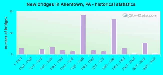
- New bridges - historical statistics
- 6Before 1900
- 51910-1919
- 71920-1929
- 41930-1939
- 31940-1949
- 371950-1959
- 41960-1969
- 31970-1979
- 331980-1989
- 61990-1999
- 12000-2009
- 112010-2019
- 12020-2022
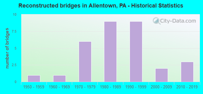
- Reconstructed bridges - Historical Statistics
- 11950-1959
- 11960-1969
- 61970-1979
- 91980-1989
- 91990-1999
- 22000-2009
- 32010-2019
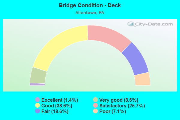
- Bridge Condition - Deck
- 1.4%Excellent
- 8.6%Very good
- 38.6%Good
- 25.7%Satisfactory
- 18.6%Fair
- 7.1%Poor
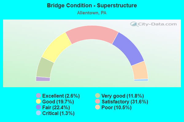
- Bridge Condition - Superstructure
- 2.6%Excellent
- 11.8%Very good
- 19.7%Good
- 31.6%Satisfactory
- 22.4%Fair
- 10.5%Poor
- 1.3%Critical
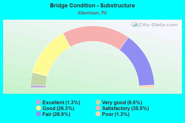
- Bridge Condition - Substructure
- 1.3%Excellent
- 6.6%Very good
- 26.3%Good
- 35.5%Satisfactory
- 28.9%Fair
- 1.3%Poor
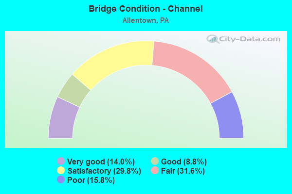
- Bridge Condition - Channel
- 14.0%Very good
- 8.8%Good
- 29.8%Satisfactory
- 31.6%Fair
- 15.8%Poor
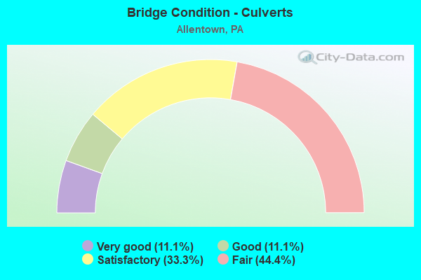
- Bridge Condition - Culverts
- 11.1%Very good
- 11.1%Good
- 33.3%Satisfactory
- 44.4%Fair
Find on map >> Show street view
Structure Number: 235, Location: 1 MI S OF MCSHERRYSTOWN (Lat: 39.790744, Lng: -77.019158), Route carried "on" structure: State highway , Year Built: 1957, Status: Open, Structure Length: 2.01m (6.59ft), Average Daily Traffic: 3,692 (year 2022), Truck Traffic: 6%, Average Future Daily Traffic: 4,329 (year 2032), Design Load: HS 20, Features Intersected: PLUM CREEK, Facility Carried by Structure: SR 2006
Minimum Vertical Clearance: 30+ m (98+ ft), Kilometerpoint: 15.702, Lanes on structure: 2, Owner: State Highway Agency, Approaching Roadway Width: 7.6m (24.9ft), Skew: 1 degrees, Material/Design: Prestressed concrete, Design/Construction: Box Beam or Girders - Multiple, Number Of Spans In Main Unit: 2, Length of Maximum Span: 9.1m (29.9ft), Curb or Sidewalk Widths: Left: 0.3m (1.0ft), Right: 0.3m (1.0ft), Curb-To-Curb Width: 9.6m (31.5ft), Out-to-Out Width: 10.2m (33.5ft)
Condition: Deck: Fair, Superstructure: Fair, Substructure: Satisfactory, Channel: Fair, Operating Rating: 46.3 metric tons, Method Used To Determine Operating Rating: Load Factor (LF), Inventory Rating: 25.4 metric tons, Method Used To Determine Inventory Rating: Load Factor (LF), Structural Evaluation: Somewhat better than minimum adequacy, Deck Geometry: Meets minimum limits, Waterway Adequacy: Better than present minimum criteria, Approach Roadway Alignment: Equal to present desirable criteria, Length Of Structure Improvement: 2.70m (8.86ft), Designated Inspection Frequency: Every 24 months, Inspection Date: March 2021, Bridge Improvement Cost: $21,000, Roadway Improvement Cost: $61,000, Total Project Cost: $279,000, Deck Structure Type: Other, Wearing Surface/Protective System: Wearing Surface: Bituminous
Find on map >> Show street view
Structure Number: 10717, Location: SOUTH COVENTRY TWP.05J11 (Lat: 40.171306, Lng: -75.690228), Route carried "on" structure: City street , Year Built: 1837, Year Reconstructed: 1983, Status: Posted for load, Structure Length: 2.07m (6.79ft), Average Daily Traffic: 1,662 (year 2019), Truck Traffic: 12%, Average Future Daily Traffic: 2,028 (year 2039), Design Load: HS 20+Mod, Features Intersected: FRENCH CREEK, Facility Carried by Structure: COVENTRYVILLE ROAD
Minimum Vertical Clearance: 30+ m (98+ ft), Kilometerpoint: 0.000, Lanes on structure: 1, Owner: County Highway Agency, Approaching Roadway Width: 6.4m (21.0ft), Material/Design: Steel, Design/Construction: Stringer/Multi-beam, Number Of Spans In Main Unit: 2, Length of Maximum Span: 9.8m (32.2ft), Curb-To-Curb Width: 4.4m (14.4ft), Out-to-Out Width: 5.2m (17.1ft)
Condition: Deck: Good, Superstructure: Satisfactory, Substructure: Fair, Channel: Poor, Operating Rating: 66.2 metric tons, Method Used To Determine Operating Rating: Load Factor (LF), Inventory Rating: 39.9 metric tons, Method Used To Determine Inventory Rating: Load Factor (LF), Structural Evaluation: Somewhat better than minimum adequacy, Deck Geometry: High priority of replacement, Waterway Adequacy: Equal to present minimum criteria, Approach Roadway Alignment: Better than present minimum criteria, Length Of Structure Improvement: 2.70m (8.86ft), Designated Inspection Frequency: Every 24 months, Other Special Inspection Frequency: Every 12 months, Inspection Date: April 2021, Other Special Inspection Date: April 2021, Bridge Improvement Cost: $8,000, Roadway Improvement Cost: $22,000, Total Project Cost: $102,000, Deck Structure Type: Concrete Cast-file-Place, Wearing Surface/Protective System: Wearing Surface: Monolithic Concrete, Deck Protection: Epoxy Coated Reinforcing
Find on map >> Show street view
Structure Number: 10744, Location: WEST DOWNINGTOWN INTERCHG (Lat: 40.070781, Lng: -75.679656), Route carried "on" structure: Interstate 76, Year Built: 1950, Year Reconstructed: 1990, Status: Open, Structure Length: 5.43m (17.81ft), Average Daily Traffic: 46,178 (year 2004), Truck Traffic: 19%, Average Future Daily Traffic: 66,798 (year 2030), Design Load: HS 20, Features Intersected: SR 0100
Minimum Vertical Clearance: 30+ m (98+ ft), Kilometerpoint: 0.000, Lanes on structure: 4, Lanes under structure: 8, Base Highway Network: Yes, Toll: On toll road, Owner: State Toll Authority, Approaching Roadway Width: 25.9m (85.0ft), Skew: 32 degrees, Material/Design: Steel, Design/Construction: Stringer/Multi-beam, Number Of Spans In Main Unit: 1, Length of Maximum Span: 51.8m (169.9ft), Curb or Sidewalk Widths: Left: 0.2m (0.7ft), Right: 0.2m (0.7ft), Curb-To-Curb Width: 25.9m (85.0ft), Out-to-Out Width: 27.6m (90.6ft)
Condition: Deck: Satisfactory, Superstructure: Satisfactory, Substructure: Fair, Operating Rating: 59.0 metric tons, Method Used To Determine Operating Rating: Load Factor (LF), Inventory Rating: 35.4 metric tons, Method Used To Determine Inventory Rating: Load Factor (LF), Structural Evaluation: Somewhat better than minimum adequacy, Deck Geometry: Superior to present desirable criteria, Underclear: High priority of corrective action, Approach Roadway Alignment: Equal to present desirable criteria, Length Of Structure Improvement: 6.30m (20.67ft), Designated Inspection Frequency: Every 24 months, Inspection Date: June 2020, Bridge Improvement Cost: $41,000, Roadway Improvement Cost: $121,000, Total Project Cost: $555,000, Deck Structure Type: Concrete Cast-file-Place, Wearing Surface/Protective System: Wearing Surface: Latex Concrete
Find on map >> Show street view
Structure Number: 22949, Location: US 22 OVER T-514 (Lat: 40.605125, Lng: -75.545472), Route carried "on" structure: US 22, Year Built: 1953, Year Reconstructed: 1988, Status: Open, Structure Length: 3.51m (11.52ft), Average Daily Traffic: 88,412 (year 2022), Truck Traffic: 5%, Average Future Daily Traffic: 113,423 (year 2032), Design Load: HS 20+Mod, Features Intersected: T-514(SPRINGHOUSE RD.)
Minimum Vertical Clearance: 30+ m (98+ ft), Kilometerpoint: 4.543, Lanes on structure: 2, Lanes under structure: 2, Base Highway Network: Yes, Owner: State Highway Agency, Approaching Roadway Width: 11.3m (37.1ft), Skew: 33 degrees, Material/Design: Steel continuous, Design/Construction: Stringer/Multi-beam, Number Of Spans In Main Unit: 3, Length of Maximum Span: 13.4m (44.0ft), Curb-To-Curb Width: 23.2m (76.1ft), Out-to-Out Width: 25.5m (83.7ft)
Condition: Deck: Good, Superstructure: Satisfactory, Substructure: Good, Operating Rating: 89.8 metric tons, Method Used To Determine Operating Rating: Load Factor (LF), Inventory Rating: 57.2 metric tons, Method Used To Determine Inventory Rating: Load Factor (LF), Structural Evaluation: Equal to present minimum criteria, Deck Geometry: Superior to present desirable criteria, Underclear: Meets minimum limits, Approach Roadway Alignment: Equal to present desirable criteria, Length Of Structure Improvement: 4.40m (14.44ft), Designated Inspection Frequency: Every 24 months, Inspection Date: July 2021, Deck Structure Type: Concrete Cast-file-Place, Wearing Surface/Protective System: Wearing Surface: Monolithic Concrete, Deck Protection: Epoxy Coated Reinforcing
Find on map >> Show street view
Structure Number: 2295, Location: US 22 OVER 28TH ST. (Lat: 40.610133, Lng: -75.524783), Route carried "on" structure: US 22, Year Built: 1953, Year Reconstructed: 1989, Status: Open, Structure Length: 3.72m (12.20ft), Average Daily Traffic: 88,412 (year 2022), Truck Traffic: 5%, Average Future Daily Traffic: 113,423 (year 2032), Design Load: HS 20+Mod, Features Intersected: T-862(28TH ST.)
Minimum Vertical Clearance: 30+ m (98+ ft), Kilometerpoint: 6.317, Lanes on structure: 4, Lanes under structure: 2, Base Highway Network: Yes, Owner: State Highway Agency, Approaching Roadway Width: 25.3m (83.0ft), Skew: 31 degrees, Material/Design: Steel continuous, Design/Construction: Stringer/Multi-beam, Number Of Spans In Main Unit: 3, Length of Maximum Span: 16.5m (54.1ft), Curb-To-Curb Width: 23.5m (77.1ft), Out-to-Out Width: 25.5m (83.7ft)
Condition: Deck: Satisfactory, Superstructure: Satisfactory, Substructure: Satisfactory, Operating Rating: 70.8 metric tons, Method Used To Determine Operating Rating: Load Factor (LF), Inventory Rating: 42.6 metric tons, Method Used To Determine Inventory Rating: Load Factor (LF), Structural Evaluation: Equal to present minimum criteria, Deck Geometry: Superior to present desirable criteria, Underclear: Meets minimum limits, Approach Roadway Alignment: Equal to present desirable criteria, Length Of Structure Improvement: 4.70m (15.42ft), Designated Inspection Frequency: Every 24 months, Inspection Date: September 2021, Deck Structure Type: Concrete Cast-file-Place, Wearing Surface/Protective System: Wearing Surface: Integral Concrete, Deck Protection: Epoxy Coated Reinforcing
Find on map >> Show street view
Structure Number: 22952, Location: US 22 OVER WHITEHALL AVE. (Lat: 40.611819, Lng: -75.518017), Route carried "on" structure: US 22, Year Built: 1953, Year Reconstructed: 1989, Status: Open, Structure Length: 4.60m (15.09ft), Average Daily Traffic: 88,412 (year 2022), Truck Traffic: 5%, Average Future Daily Traffic: 113,423 (year 2032), Design Load: HS 20+Mod, Features Intersected: T-616(WHITEHALL AVE.)
Minimum Vertical Clearance: 30+ m (98+ ft), Kilometerpoint: 7.150, Lanes on structure: 4, Lanes under structure: 2, Base Highway Network: Yes, Owner: State Highway Agency, Approaching Roadway Width: 11.9m (39.0ft), Skew: 34 degrees, Material/Design: Steel continuous, Design/Construction: Stringer/Multi-beam, Number Of Spans In Main Unit: 3, Length of Maximum Span: 21.3m (69.9ft), Curb-To-Curb Width: 23.5m (77.1ft), Out-to-Out Width: 25.5m (83.7ft)
Condition: Deck: Good, Superstructure: Satisfactory, Substructure: Satisfactory, Operating Rating: 63.5 metric tons, Method Used To Determine Operating Rating: Load Factor (LF), Inventory Rating: 38.1 metric tons, Method Used To Determine Inventory Rating: Load Factor (LF), Structural Evaluation: Equal to present minimum criteria, Deck Geometry: Superior to present desirable criteria, Underclear: Meets minimum limits, Approach Roadway Alignment: Equal to present desirable criteria, Length Of Structure Improvement: 5.50m (18.04ft), Designated Inspection Frequency: Every 24 months, Inspection Date: June 2021, Deck Structure Type: Concrete Cast-file-Place, Wearing Surface/Protective System: Wearing Surface: Monolithic Concrete, Deck Protection: Epoxy Coated Reinforcing
Find on map >> Show street view
Structure Number: 22955, Location: OVER 19TH ST./ ROTH AVE. (Lat: 40.615808, Lng: -75.506089), Route carried "on" structure: US 22, Year Built: 1953, Year Reconstructed: 1984, Status: Open, Structure Length: 9.20m (30.18ft), Average Daily Traffic: 88,412 (year 2022), Truck Traffic: 5%, Average Future Daily Traffic: 113,423 (year 2032), Design Load: HS 20+Mod, Features Intersected: LR 163* ROTH AVE.&19TH S
Minimum Vertical Clearance: 30+ m (98+ ft), Kilometerpoint: 8.019, Lanes on structure: 4, Lanes under structure: 4, Base Highway Network: Yes, Owner: State Highway Agency, Approaching Roadway Width: 21.9m (71.9ft), Skew: 30 degrees, Material/Design: Steel, Design/Construction: Stringer/Multi-beam, Number Of Spans In Main Unit: 2, Number Of Approach Spans: 2, Length of Maximum Span: 38.1m (125.0ft), Curb-To-Curb Width: 19.5m (64.0ft), Out-to-Out Width: 21.8m (71.5ft)
Condition: Deck: Satisfactory, Superstructure: Satisfactory, Substructure: Satisfactory, Operating Rating: 87.1 metric tons, Method Used To Determine Operating Rating: Load Factor (LF), Inventory Rating: 51.7 metric tons, Method Used To Determine Inventory Rating: Load Factor (LF), Structural Evaluation: Equal to present minimum criteria, Deck Geometry: Somewhat better than minimum adequacy, Underclear: Superior to present desirable criteria, Approach Roadway Alignment: Equal to present desirable criteria, Length Of Structure Improvement: 10.20m (33.46ft), Designated Inspection Frequency: Every 24 months, Inspection Date: April 2021, Bridge Improvement Cost: $38,000, Roadway Improvement Cost: $111,000, Total Project Cost: $510,000, Deck Structure Type: Concrete Cast-file-Place, Wearing Surface/Protective System: Wearing Surface: Monolithic Concrete, Deck Protection: Epoxy Coated Reinforcing
Find on map >> Show street view
Structure Number: 22957, Location: 15TH ST.INTERCHANGE (Lat: 40.618500, Lng: -75.501122), Route carried "on" structure: US 22, Year Built: 1953, Year Reconstructed: 1984, Status: Open, Structure Length: 2.47m (8.10ft), Average Daily Traffic: 88,412 (year 2022), Truck Traffic: 5%, Average Future Daily Traffic: 113,423 (year 2032), Design Load: HS 20+Mod, Features Intersected: TWP.RD.603* 15TH STREET
Minimum Vertical Clearance: 30+ m (98+ ft), Kilometerpoint: 8.859, Lanes on structure: 6, Lanes under structure: 4, Base Highway Network: Yes, Owner: State Highway Agency, Approaching Roadway Width: 30.2m (99.1ft), Skew: 33 degrees, Material/Design: Steel, Design/Construction: Stringer/Multi-beam, Number Of Spans In Main Unit: 1, Length of Maximum Span: 22.9m (75.1ft), Curb-To-Curb Width: 29.4m (96.5ft), Out-to-Out Width: 31.4m (103.0ft)
Condition: Deck: Good, Superstructure: Satisfactory, Substructure: Satisfactory, Operating Rating: 90.7 metric tons, Method Used To Determine Operating Rating: Load Factor (LF), Inventory Rating: 54.4 metric tons, Method Used To Determine Inventory Rating: Load Factor (LF), Structural Evaluation: Equal to present minimum criteria, Deck Geometry: Better than present minimum criteria, Underclear: Meets minimum limits, Approach Roadway Alignment: Equal to present desirable criteria, Length Of Structure Improvement: 3.20m (10.50ft), Designated Inspection Frequency: Every 24 months, Inspection Date: September 2021, Deck Structure Type: Concrete Cast-file-Place, Wearing Surface/Protective System: Wearing Surface: Monolithic Concrete, Deck Protection: Epoxy Coated Reinforcing
Find on map >> Show street view
Structure Number: 22976, Location: US 22 OVER IRVING ST. (Lat: 40.638100, Lng: -75.447147), Route carried "on" structure: US 22, Year Built: 1952, Year Reconstructed: 1999, Status: Open, Structure Length: 3.44m (11.29ft), Average Daily Traffic: 101,210 (year 2022), Truck Traffic: 4%, Average Future Daily Traffic: 109,216 (year 2032), Design Load: HS 25 or greater, Features Intersected: T-638(IRVING ST.)
Minimum Vertical Clearance: 30+ m (98+ ft), Kilometerpoint: 13.837, Lanes on structure: 4, Lanes under structure: 2, Base Highway Network: Yes, Owner: State Highway Agency, Approaching Roadway Width: 15.8m (51.8ft), Skew: 1 degrees, Material/Design: Steel continuous, Design/Construction: Stringer/Multi-beam, Number Of Spans In Main Unit: 3, Length of Maximum Span: 15.2m (49.9ft), Curb or Sidewalk Widths: Left: 0.2m (0.7ft), Right: 0.2m (0.7ft), Curb-To-Curb Width: 31.7m (104.0ft), Out-to-Out Width: 33.6m (110.2ft)
Condition: Deck: Good, Superstructure: Good, Substructure: Good, Operating Rating: 82.6 metric tons, Method Used To Determine Operating Rating: Load Factor (LF), Inventory Rating: 49.0 metric tons, Method Used To Determine Inventory Rating: Load Factor (LF), Structural Evaluation: Better than present minimum criteria, Deck Geometry: Superior to present desirable criteria, Underclear: Equal to present minimum criteria, Approach Roadway Alignment: Equal to present desirable criteria, Length Of Structure Improvement: 4.30m (14.11ft), Designated Inspection Frequency: Every 48 months, Inspection Date: October 2019, Bridge Improvement Cost: $297,000, Roadway Improvement Cost: $874,000, Total Project Cost: $4,006,000, Deck Structure Type: Concrete Cast-file-Place, Wearing Surface/Protective System: Wearing Surface: Monolithic Concrete, Deck Protection: Epoxy Coated Reinforcing
Find on map >> Show street view
Structure Number: 2305, Location: 0.8 M.S.OF CEDAR CREST (Lat: 40.566142, Lng: -75.502544), Route carried "on" structure: Interstate 78, Year Built: 1958, Year Reconstructed: 1988, Status: Open, Structure Length: 20.15m (66.11ft), Average Daily Traffic: 90,738 (year 2022), Truck Traffic: 20%, Average Future Daily Traffic: 117,029 (year 2032), Design Load: HS 25 or greater, Features Intersected: SR 2010 & LT LEHIGH CR
Minimum Vertical Clearance: 30+ m (98+ ft), Kilometerpoint: 20.658, Lanes on structure: 6, Lanes under structure: 2, Base Highway Network: Yes, Owner: State Highway Agency, Approaching Roadway Width: 32.6m (107.0ft), Skew: 30 degrees, Material/Design: Concrete, Design/Construction: Arch - Deck, Number Of Spans In Main Unit: 1, Number Of Approach Spans: 9, Length of Maximum Span: 70.4m (231.0ft), Curb or Sidewalk Widths: Left: 0.2m (0.7ft), Right: 0.2m (0.7ft), Curb-To-Curb Width: 32.6m (107.0ft), Out-to-Out Width: 34.6m (113.5ft)
Condition: Deck: Satisfactory, Superstructure: Fair, Substructure: Fair, Channel: Very good, Operating Rating: 44.5 metric tons, Method Used To Determine Operating Rating: Load Factor (LF), Inventory Rating: 24.5 metric tons, Method Used To Determine Inventory Rating: Load Factor (LF), Structural Evaluation: Somewhat better than minimum adequacy, Deck Geometry: Superior to present desirable criteria, Underclear: Meets minimum limits, Waterway Adequacy: Superior to present desirable criteria, Approach Roadway Alignment: Equal to present desirable criteria, Length Of Structure Improvement: 20.80m (68.24ft), Designated Inspection Frequency: Every 24 months, Inspection Date: November 2019, Deck Structure Type: Concrete Cast-file-Place, Wearing Surface/Protective System: Wearing Surface: Monolithic Concrete, Deck Protection: Epoxy Coated Reinforcing
Find on map >> Show street view
Structure Number: 23052, Location: OVER OXFORD DRIVE (Lat: 40.565717, Lng: -75.497408), Route carried "on" structure: Interstate 78, Year Built: 1989, Status: Open, Structure Length: 1.92m (6.30ft), Average Daily Traffic: 90,738 (year 2022), Truck Traffic: 20%, Average Future Daily Traffic: 117,029 (year 2032), Design Load: HS 25 or greater, Features Intersected: SR 2007 (LR 39016)
Minimum Vertical Clearance: 30+ m (98+ ft), Kilometerpoint: 20.658, Lanes on structure: 6, Lanes under structure: 2, Base Highway Network: Yes, Owner: State Highway Agency, Approaching Roadway Width: 37.2m (122.0ft), Skew: 33 degrees, Material/Design: Prestressed concrete, Design/Construction: Box Beam or Girders - Single/Spread, Number Of Spans In Main Unit: 1, Length of Maximum Span: 18.9m (62.0ft), Curb or Sidewalk Widths: Left: 0.2m (0.7ft), Right: 0.2m (0.7ft), Curb-To-Curb Width: 36.3m (119.1ft), Out-to-Out Width: 38.3m (125.7ft)
Condition: Deck: Good, Superstructure: Satisfactory, Substructure: Satisfactory, Inventory Rating: 49.0 metric tons, Method Used To Determine Inventory Rating: Load Factor (LF), Structural Evaluation: Equal to present minimum criteria, Deck Geometry: Superior to present desirable criteria, Underclear: Equal to present minimum criteria, Approach Roadway Alignment: Equal to present desirable criteria, Length Of Structure Improvement: 2.60m (8.53ft), Designated Inspection Frequency: Every 48 months, Inspection Date: January 2020, Deck Structure Type: Concrete Cast-file-Place, Wearing Surface/Protective System: Wearing Surface: Monolithic Concrete, Deck Protection: Epoxy Coated Reinforcing
Find on map >> Show street view
Structure Number: 23056, Location: LEHIGH ST.EXIT 57(18A) (Lat: 40.564350, Lng: -75.484872), Route carried "on" structure: Interstate 78, Year Built: 1989, Status: Open, Structure Length: 3.51m (11.52ft), Average Daily Traffic: 100,864 (year 2022), Truck Traffic: 15%, Average Future Daily Traffic: 117,029 (year 2032), Design Load: HS 25 or greater, Features Intersected: SR 2005 (LR 158)LEHIGH
Minimum Vertical Clearance: 30+ m (98+ ft), Kilometerpoint: 22.270, Lanes on structure: 8, Lanes under structure: 8, Base Highway Network: Yes, Owner: State Highway Agency, Approaching Roadway Width: 52.7m (172.9ft), Skew: 31 degrees, Material/Design: Steel, Design/Construction: Stringer/Multi-beam, Number Of Spans In Main Unit: 1, Length of Maximum Span: 33.5m (109.9ft), Curb or Sidewalk Widths: Left: 0.2m (0.7ft), Right: 0.2m (0.7ft), Curb-To-Curb Width: 50.9m (167.0ft), Out-to-Out Width: 53.4m (175.2ft)
Condition: Deck: Good, Superstructure: Good, Substructure: Satisfactory, Operating Rating: 61.7 metric tons, Method Used To Determine Operating Rating: Load Factor (LF), Inventory Rating: 37.2 metric tons, Method Used To Determine Inventory Rating: Load Factor (LF), Structural Evaluation: Equal to present minimum criteria, Deck Geometry: Superior to present desirable criteria, Underclear: Equal to present minimum criteria, Approach Roadway Alignment: Equal to present desirable criteria, Length Of Structure Improvement: 4.40m (14.44ft), Designated Inspection Frequency: Every 48 months, Inspection Date: Febuary 2020, Deck Structure Type: Concrete Cast-file-Place, Wearing Surface/Protective System: Wearing Surface: Monolithic Concrete, Deck Protection: Epoxy Coated Reinforcing
Find on map >> Show street view
Structure Number: 23057, Location: NEAR LEHIGH ST.EXIT (Lat: 40.564131, Lng: -75.482658), Route carried "on" structure: Interstate 78, Year Built: 1989, Status: Open, Structure Length: 5.00m (16.40ft), Average Daily Traffic: 100,864 (year 2022), Truck Traffic: 15%, Average Future Daily Traffic: 117,029 (year 2032), Design Load: HS 25 or greater, Features Intersected: NORFOLK SOUTHERN RR
Minimum Vertical Clearance: 30+ m (98+ ft), Kilometerpoint: 22.270, Lanes on structure: 6, Base Highway Network: Yes, Owner: State Highway Agency, Approaching Roadway Width: 39.6m (129.9ft), Skew: 31 degrees, Material/Design: Prestressed concrete, Design/Construction: Box Beam or Girders - Single/Spread, Number Of Spans In Main Unit: 3, Length of Maximum Span: 20.1m (65.9ft), Curb or Sidewalk Widths: Left: 0.2m (0.7ft), Right: 0.2m (0.7ft), Curb-To-Curb Width: 38.7m (127.0ft), Out-to-Out Width: 40.5m (132.9ft)
Condition: Deck: Satisfactory, Superstructure: Satisfactory, Substructure: Satisfactory, Operating Rating: 82.6 metric tons, Method Used To Determine Operating Rating: Load Factor (LF), Inventory Rating: 48.1 metric tons, Method Used To Determine Inventory Rating: Load Factor (LF), Structural Evaluation: Equal to present minimum criteria, Deck Geometry: Superior to present desirable criteria, Underclear: High priority of corrective action, Approach Roadway Alignment: Equal to present desirable criteria, Length Of Structure Improvement: 5.90m (19.36ft), Designated Inspection Frequency: Every 48 months, Inspection Date: March 2020, Deck Structure Type: Concrete Cast-file-Place, Wearing Surface/Protective System: Wearing Surface: Monolithic Concrete, Deck Protection: Epoxy Coated Reinforcing
Find on map >> Show street view
Structure Number: 23059, Location: EMMAUS AVE.EXIT #58(18B) (Lat: 40.563475, Lng: -75.475981), Route carried "on" structure: Interstate 78, Year Built: 1989, Status: Open, Structure Length: 3.57m (11.71ft), Average Daily Traffic: 100,864 (year 2022), Truck Traffic: 15%, Average Future Daily Traffic: 117,029 (year 2032), Design Load: HS 20, Features Intersected: SR 2002 (LR 39013)
Minimum Vertical Clearance: 30+ m (98+ ft), Kilometerpoint: 23.073, Lanes on structure: 3, Lanes under structure: 8, Base Highway Network: Yes, Owner: State Highway Agency, Approaching Roadway Width: 40.2m (131.9ft), Skew: 31 degrees, Material/Design: Steel, Design/Construction: Stringer/Multi-beam, Number Of Spans In Main Unit: 1, Length of Maximum Span: 34.4m (112.9ft), Curb or Sidewalk Widths: Left: 0.2m (0.7ft), Right: 0.2m (0.7ft), Curb-To-Curb Width: 39.9m (130.9ft), Out-to-Out Width: 42.7m (140.1ft)
Condition: Deck: Good, Superstructure: Good, Substructure: Good, Operating Rating: 66.2 metric tons, Method Used To Determine Operating Rating: Load Factor (LF), Inventory Rating: 39.9 metric tons, Method Used To Determine Inventory Rating: Load Factor (LF), Structural Evaluation: Better than present minimum criteria, Deck Geometry: Superior to present desirable criteria, Underclear: Equal to present minimum criteria, Approach Roadway Alignment: Equal to present desirable criteria, Length Of Structure Improvement: 4.50m (14.76ft), Designated Inspection Frequency: Every 24 months, Inspection Date: January 2020, Deck Structure Type: Concrete Cast-file-Place, Wearing Surface/Protective System: Wearing Surface: Monolithic Concrete, Deck Protection: Epoxy Coated Reinforcing
Find on map >> Show street view
Structure Number: 2307, Location: SUMMIT LAWN EXIT #59(19) (Lat: 40.560225, Lng: -75.450261), Route carried "on" structure: State highway , Year Built: 1988, Status: Open, Structure Length: 8.96m (29.40ft), Average Daily Traffic: 5,033 (year 2021), Truck Traffic: 3%, Average Future Daily Traffic: 11,078 (year 2032), Design Load: HS 20, Features Intersected: I-78 & PA 309, Facility Carried by Structure: SR2059(W.ROCK RD.)
Minimum Vertical Clearance: 30+ m (98+ ft), Kilometerpoint: 0.000, Lanes on structure: 2, Lanes under structure: 7, Owner: State Highway Agency, Approaching Roadway Width: 13.4m (44.0ft), Material/Design: Steel continuous, Design/Construction: Stringer/Multi-beam, Number Of Spans In Main Unit: 2, Length of Maximum Span: 48.8m (160.1ft), Curb or Sidewalk Widths: Left: 0.2m (0.7ft), Right: 0.2m (0.7ft), Curb-To-Curb Width: 13.4m (44.0ft), Out-to-Out Width: 14.5m (47.6ft)
Condition: Deck: Good, Superstructure: Good, Substructure: Good, Operating Rating: 67.1 metric tons, Method Used To Determine Operating Rating: Load Factor (LF), Inventory Rating: 39.9 metric tons, Method Used To Determine Inventory Rating: Load Factor (LF), Structural Evaluation: Better than present minimum criteria, Deck Geometry: Equal to present minimum criteria, Underclear: Superior to present desirable criteria, Approach Roadway Alignment: Equal to present desirable criteria, Length Of Structure Improvement: 9.90m (32.48ft), Designated Inspection Frequency: Every 48 months, Inspection Date: October 2018, Deck Structure Type: Concrete Cast-file-Place, Wearing Surface/Protective System: Wearing Surface: Monolithic Concrete, Deck Protection: Epoxy Coated Reinforcing
Find on map >> Show street view
Structure Number: 23073, Location: I-78 OVER VERA CRUZ RD. (Lat: 40.556958, Lng: -75.439369), Route carried "on" structure: Interstate 78, Year Built: 1989, Year Reconstructed: 2000, Status: Open, Structure Length: 5.64m (18.50ft), Average Daily Traffic: 69,174 (year 2022), Truck Traffic: 28%, Average Future Daily Traffic: 80,261 (year 2032), Design Load: HS 25 or greater, Features Intersected: SR 2023(LR 39107)
Minimum Vertical Clearance: 30+ m (98+ ft), Kilometerpoint: 26.274, Lanes on structure: 6, Lanes under structure: 2, Base Highway Network: Yes, Owner: State Highway Agency, Approaching Roadway Width: 37.2m (122.0ft), Skew: 30 degrees, Material/Design: Prestressed concrete, Design/Construction: Box Beam or Girders - Single/Spread, Number Of Spans In Main Unit: 3, Length of Maximum Span: 21.6m (70.9ft), Curb or Sidewalk Widths: Left: 0.2m (0.7ft), Right: 0.2m (0.7ft), Curb-To-Curb Width: 37.2m (122.0ft), Out-to-Out Width: 38.3m (125.7ft)
Condition: Deck: Good, Superstructure: Good, Substructure: Good, Operating Rating: 88.9 metric tons, Method Used To Determine Operating Rating: Load Factor (LF), Inventory Rating: 39.0 metric tons, Method Used To Determine Inventory Rating: Load Factor (LF), Structural Evaluation: Better than present minimum criteria, Deck Geometry: Superior to present desirable criteria, Underclear: Equal to present desirable criteria, Approach Roadway Alignment: Equal to present desirable criteria, Length Of Structure Improvement: 6.60m (21.65ft), Designated Inspection Frequency: Every 48 months, Inspection Date: September 2018, Deck Structure Type: Concrete Cast-file-Place, Wearing Surface/Protective System: Wearing Surface: Monolithic Concrete, Deck Protection: Epoxy Coated Reinforcing
Find on map >> Show street view
Structure Number: 23079, Location: .5 M. EAST OF PA. 309 (Lat: 40.558569, Lng: -75.422739), Route carried "on" structure: Interstate 78, Year Built: 1989, Status: Open, Structure Length: 0.88m (2.89ft), Average Daily Traffic: 67,538 (year 2021), Truck Traffic: 25%, Average Future Daily Traffic: 80,261 (year 2032), Design Load: HS 20, Features Intersected: TRIB. TO SAUCON CREEK
Minimum Vertical Clearance: 30+ m (98+ ft), Kilometerpoint: 27.893, Lanes on structure: 4, Base Highway Network: Yes, Owner: State Highway Agency, Approaching Roadway Width: 6.4m (21.0ft), Skew: 24 degrees, Material/Design: Concrete, Design/Construction: Culvert, Number Of Spans In Main Unit: 2, Length of Maximum Span: 4.3m (14.1ft)
Condition: Channel: Satisfactory, Culverts: Good, Inventory Rating: 77.1 metric tons, Method Used To Determine Inventory Rating: Load Factor (LF), Structural Evaluation: Better than present minimum criteria, Waterway Adequacy: Superior to present desirable criteria, Approach Roadway Alignment: Equal to present desirable criteria, Length Of Structure Improvement: 1.60m (5.25ft), Designated Inspection Frequency: Every 48 months, Inspection Date: January 2019
Find on map >> Show street view
Structure Number: 23107, Location: PA.145SB OVER PA.309NB. (Lat: 40.557553, Lng: -75.436464), Route carried "on" structure: State highway 145, Year Built: 1958, Year Reconstructed: 1988, Status: Open, Structure Length: 2.50m (8.20ft), Average Daily Traffic: 4,308 (year 2021), Truck Traffic: 3%, Average Future Daily Traffic: 5,840 (year 2032), Design Load: HS 20, Features Intersected: PA 309 NB(LR 781)
Minimum Vertical Clearance: 30+ m (98+ ft), Kilometerpoint: 0.000, Lanes on structure: 1, Lanes under structure: 2, Base Highway Network: Yes, Owner: State Highway Agency, Approaching Roadway Width: 11.6m (38.1ft), Skew: 5 degrees, Material/Design: Steel, Design/Construction: Stringer/Multi-beam, Number Of Spans In Main Unit: 1, Length of Maximum Span: 23.8m (78.1ft), Curb or Sidewalk Widths: Left: 0.2m (0.7ft), Right: 0.2m (0.7ft), Curb-To-Curb Width: 11.6m (38.1ft), Out-to-Out Width: 12.6m (41.3ft)
Condition: Deck: Satisfactory, Superstructure: Satisfactory, Substructure: Satisfactory, Operating Rating: 82.6 metric tons, Method Used To Determine Operating Rating: Load Factor (LF), Inventory Rating: 49.0 metric tons, Method Used To Determine Inventory Rating: Load Factor (LF), Structural Evaluation: Equal to present minimum criteria, Deck Geometry: Somewhat better than minimum adequacy, Underclear: Somewhat better than minimum adequacy, Approach Roadway Alignment: Equal to present desirable criteria, Length Of Structure Improvement: 3.20m (10.50ft), Designated Inspection Frequency: Every 24 months, Inspection Date: January 2020, Deck Structure Type: Concrete Cast-file-Place, Wearing Surface/Protective System: Wearing Surface: Monolithic Concrete, Deck Protection: Epoxy Coated Reinforcing
Find on map >> Show street view
Structure Number: 23109, Location: SUSQUEHANNA ST. BRIDGE (Lat: 40.590372, Lng: -75.460989), Route carried "on" structure: State highway 145, Year Built: 1989, Status: Open, Structure Length: 8.75m (28.71ft), Average Daily Traffic: 14,292 (year 2022), Truck Traffic: 3%, Average Future Daily Traffic: 15,996 (year 2032), Design Load: HS 25 or greater, Features Intersected: TROUT CREEK & N.S. RR
Minimum Vertical Clearance: 30+ m (98+ ft), Kilometerpoint: 4.675, Lanes on structure: 3, Base Highway Network: Yes, Owner: City or Municipal Highway Agency, Approaching Roadway Width: 12.2m (40.0ft), Material/Design: Steel continuous, Design/Construction: Stringer/Multi-beam, Number Of Spans In Main Unit: 4, Length of Maximum Span: 24.7m (81.0ft), Curb or Sidewalk Widths: Left: 1.8m (5.9ft), Right: 1.5m (4.9ft), Curb-To-Curb Width: 12.2m (40.0ft), Out-to-Out Width: 16.6m (54.5ft)
Condition: Deck: Good, Superstructure: Good, Substructure: Good, Channel: Good, Operating Rating: 75.3 metric tons, Method Used To Determine Operating Rating: Load Factor (LF), Inventory Rating: 45.4 metric tons, Method Used To Determine Inventory Rating: Load Factor (LF), Structural Evaluation: Better than present minimum criteria, Deck Geometry: Meets minimum limits, Underclear: High priority of corrective action, Waterway Adequacy: Superior to present desirable criteria, Approach Roadway Alignment: Better than present minimum criteria, Length Of Structure Improvement: 9.50m (31.17ft), Designated Inspection Frequency: Every 24 months, Inspection Date: June 2020, Bridge Improvement Cost: $190,000, Roadway Improvement Cost: $560,000, Total Project Cost: $2,566,000, Deck Structure Type: Concrete Cast-file-Place, Wearing Surface/Protective System: Wearing Surface: Monolithic Concrete, Deck Protection: Epoxy Coated Reinforcing
Find on map >> Show street view
Structure Number: 2311, Location: LEHIGH STREET BRIDGE (Lat: 40.597092, Lng: -75.467153), Route carried "on" structure: State highway 145, Year Built: 1940, Status: Open, Structure Length: 3.54m (11.61ft), Average Daily Traffic: 13,396 (year 2021), Average Future Daily Traffic: 10,502 (year 2032), Design Load: HS 20+Mod, Features Intersected: LITTLE LEHIGH CREEK, Facility Carried by Structure: SOUTH LEHIGH ST.
Minimum Vertical Clearance: 30+ m (98+ ft), Kilometerpoint: 5.599, Lanes on structure: 3, Base Highway Network: Yes, Owner: County Highway Agency, Approaching Roadway Width: 13.1m (43.0ft), Skew: 1 degrees, Material/Design: Steel, Design/Construction: Stringer/Multi-beam, Number Of Spans In Main Unit: 2, Length of Maximum Span: 16.2m (53.1ft), Curb or Sidewalk Widths: Left: 2.6m (8.5ft), Right: 2.6m (8.5ft), Curb-To-Curb Width: 12.8m (42.0ft), Out-to-Out Width: 18.9m (62.0ft)
Condition: Deck: Poor, Superstructure: Poor, Substructure: Fair, Channel: Fair, Operating Rating: 53.5 metric tons, Method Used To Determine Operating Rating: Load Factor (LF), Inventory Rating: 31.8 metric tons, Method Used To Determine Inventory Rating: Load Factor (LF), Structural Evaluation: Meets minimum limits, Deck Geometry: Meets minimum limits, Waterway Adequacy: Equal to present minimum criteria, Approach Roadway Alignment: Better than present minimum criteria, Length Of Structure Improvement: 4.40m (14.44ft), Designated Inspection Frequency: Every 24 months, Other Special Inspection Frequency: Every 12 months, Inspection Date: May 2020, Other Special Inspection Date: May 2021, Bridge Improvement Cost: $83,000, Roadway Improvement Cost: $243,000, Total Project Cost: $1,116,000, Deck Structure Type: Open Grating
Find on map >> Show street view
Structure Number: 23111, Location: OVER SUMNER AVE. (Lat: 40.616853, Lng: -75.478678), Route carried "on" structure: State highway 145, Year Built: 1960, Year Reconstructed: 1989, Status: Open, Structure Length: 7.89m (25.89ft), Average Daily Traffic: 47,891 (year 2020), Truck Traffic: 1%, Average Future Daily Traffic: 46,849 (year 2032), Design Load: HS 20, Features Intersected: SUMNER AVE.
Minimum Vertical Clearance: 30+ m (98+ ft), Kilometerpoint: 8.285, Lanes on structure: 4, Lanes under structure: 2, Base Highway Network: Yes, Owner: State Highway Agency, Approaching Roadway Width: 15.2m (49.9ft), Skew: 1 degrees, Material/Design: Steel continuous, Design/Construction: Stringer/Multi-beam, Number Of Spans In Main Unit: 4, Length of Maximum Span: 22.6m (74.1ft), Curb or Sidewalk Widths: Left: 1.5m (4.9ft), Right: 1.5m (4.9ft), Curb-To-Curb Width: 15.2m (49.9ft), Out-to-Out Width: 19.1m (62.7ft)
Condition: Deck: Fair, Superstructure: Satisfactory, Substructure: Satisfactory, Operating Rating: 49.9 metric tons, Method Used To Determine Operating Rating: Load Factor (LF), Inventory Rating: 29.9 metric tons, Method Used To Determine Inventory Rating: Load Factor (LF), Structural Evaluation: Equal to present minimum criteria, Deck Geometry: High priority of corrective action, Underclear: Superior to present desirable criteria, Approach Roadway Alignment: Equal to present desirable criteria, Length Of Structure Improvement: 8.80m (28.87ft), Designated Inspection Frequency: Every 24 months, Inspection Date: August 2020, Deck Structure Type: Concrete Cast-file-Place, Wearing Surface/Protective System: Wearing Surface: Integral Concrete, Membrane: Epoxy
Find on map >> Show street view
Structure Number: 23112, Location: 7TH ST.OVER JORDAN CREEK (Lat: 40.623244, Lng: -75.481692), Route carried "on" structure: State highway 145, Year Built: 1929, Year Reconstructed: 2002, Status: Open, Structure Length: 5.91m (19.39ft), Average Daily Traffic: 47,891 (year 2020), Truck Traffic: 1%, Average Future Daily Traffic: 46,849 (year 2032), Design Load: HS 20, Features Intersected: JORDAN CREEK
Minimum Vertical Clearance: 30+ m (98+ ft), Kilometerpoint: 8.285, Lanes on structure: 4, Base Highway Network: Yes, Owner: State Highway Agency, Approaching Roadway Width: 18.3m (60.0ft), Skew: 21 degrees, Material/Design: Concrete, Design/Construction: Tee Beam, Number Of Spans In Main Unit: 4, Length of Maximum Span: 14.0m (45.9ft), Curb or Sidewalk Widths: Left: 1.8m (5.9ft), Right: 1.8m (5.9ft), Curb-To-Curb Width: 18.3m (60.0ft), Out-to-Out Width: 23.7m (77.8ft)
Condition: Deck: Fair, Superstructure: Fair, Substructure: Fair, Channel: Fair, Operating Rating: 47.2 metric tons, Method Used To Determine Operating Rating: Load Factor (LF), Inventory Rating: 28.1 metric tons, Method Used To Determine Inventory Rating: Load Factor (LF), Structural Evaluation: Somewhat better than minimum adequacy, Deck Geometry: Somewhat better than minimum adequacy, Waterway Adequacy: Equal to present minimum criteria, Approach Roadway Alignment: Equal to present desirable criteria, Length Of Structure Improvement: 6.90m (22.64ft), Designated Inspection Frequency: Every 24 months, Inspection Date: August 2020, Deck Structure Type: Concrete Cast-file-Place, Wearing Surface/Protective System: Wearing Surface: Integral Concrete
Find on map >> Show street view
Structure Number: 23148, Location: NEAR JCT SR 2036 (Lat: 40.547872, Lng: -75.423469), Route carried "on" structure: State highway 309, Year Built: 1929, Year Reconstructed: 1970, Status: Open, Structure Length: 2.38m (7.81ft), Average Daily Traffic: 25,271 (year 2020), Truck Traffic: 12%, Average Future Daily Traffic: 41,972 (year 2032), Design Load: HS 20, Features Intersected: SAUCON CREEK
Minimum Vertical Clearance: 30+ m (98+ ft), Kilometerpoint: 5.655, Lanes on structure: 4, Base Highway Network: Yes, Owner: State Highway Agency, Approaching Roadway Width: 21.3m (69.9ft), Skew: 30 degrees, Material/Design: Concrete, Design/Construction: Tee Beam, Number Of Spans In Main Unit: 2, Length of Maximum Span: 11.6m (38.1ft), Curb-To-Curb Width: 21.3m (69.9ft), Out-to-Out Width: 23.2m (76.1ft)
Condition: Deck: Satisfactory, Superstructure: Satisfactory, Substructure: Fair, Channel: Poor, Operating Rating: 47.2 metric tons, Method Used To Determine Operating Rating: Load Factor (LF), Inventory Rating: 28.1 metric tons, Method Used To Determine Inventory Rating: Load Factor (LF), Structural Evaluation: Somewhat better than minimum adequacy, Deck Geometry: Superior to present desirable criteria, Waterway Adequacy: Equal to present desirable criteria, Approach Roadway Alignment: Equal to present desirable criteria, Length Of Structure Improvement: 3.10m (10.17ft), Designated Inspection Frequency: Every 24 months, Inspection Date: December 2019, Bridge Improvement Cost: $54,000, Roadway Improvement Cost: $158,000, Total Project Cost: $726,000, Deck Structure Type: Concrete Cast-file-Place, Wearing Surface/Protective System: Wearing Surface: Epoxy Overlay
Find on map >> Show street view
Structure Number: 23151, Location: PA.309 OVER I-78 (Lat: 40.554533, Lng: -75.431894), Route carried "on" structure: State highway 309, Year Built: 1988, Status: Open, Structure Length: 11.49m (37.70ft), Average Daily Traffic: 49,356 (year 2022), Truck Traffic: 8%, Average Future Daily Traffic: 60,441 (year 2032), Design Load: HS 25 or greater, Features Intersected: I-78 (LR 1045)
Minimum Vertical Clearance: 30+ m (98+ ft), Kilometerpoint: 7.569, Lanes on structure: 4, Lanes under structure: 12, Base Highway Network: Yes, Owner: State Highway Agency, Approaching Roadway Width: 22.6m (74.1ft), Skew: 34 degrees, Material/Design: Steel continuous, Design/Construction: Stringer/Multi-beam, Number Of Spans In Main Unit: 2, Number Of Approach Spans: 2, Length of Maximum Span: 39.9m (130.9ft), Curb or Sidewalk Widths: Left: 0.2m (0.7ft), Right: 0.2m (0.7ft), Curb-To-Curb Width: 22.9m (75.1ft), Out-to-Out Width: 24.5m (80.4ft)
Condition: Deck: Satisfactory, Superstructure: Satisfactory, Substructure: Satisfactory, Operating Rating: 46.3 metric tons, Method Used To Determine Operating Rating: Load Factor (LF), Inventory Rating: 28.1 metric tons, Method Used To Determine Inventory Rating: Load Factor (LF), Structural Evaluation: Equal to present minimum criteria, Deck Geometry: Superior to present desirable criteria, Underclear: Equal to present minimum criteria, Approach Roadway Alignment: Equal to present desirable criteria, Length Of Structure Improvement: 12.50m (41.01ft), Designated Inspection Frequency: Every 24 months, Inspection Date: April 2020, Deck Structure Type: Concrete Cast-file-Place, Wearing Surface/Protective System: Wearing Surface: Monolithic Concrete, Deck Protection: Epoxy Coated Reinforcing
Find on map >> Show street view
Structure Number: 23215, Location: TILGHMAN W.OF CEDAR CREST (Lat: 40.595458, Lng: -75.535750), Route carried "on" structure: State highway , Year Built: 1936, Status: Open, Structure Length: 1.83m (6.00ft), Average Daily Traffic: 31,562 (year 2021), Truck Traffic: 2%, Average Future Daily Traffic: 27,727 (year 2032), Design Load: HS 20, Features Intersected: PRIVATE RD.& L.CEDAR CK., Facility Carried by Structure: SR 1002 (LR 443)
Minimum Vertical Clearance: 30+ m (98+ ft), Kilometerpoint: 8.164, Lanes on structure: 2, Owner: State Highway Agency, Approaching Roadway Width: 15.2m (49.9ft), Material/Design: Concrete, Design/Construction: Arch - Deck, Number Of Spans In Main Unit: 1, Length of Maximum Span: 18.3m (60.0ft), Curb-To-Curb Width: 14.5m (47.6ft), Out-to-Out Width: 16.5m (54.1ft)
Condition: Superstructure: Satisfactory, Substructure: Satisfactory, Channel: Fair, Operating Rating: 71.7 metric tons, Method Used To Determine Operating Rating: Allowable Stress (AS), Inventory Rating: 51.7 metric tons, Method Used To Determine Inventory Rating: Allowable Stress (AS), Structural Evaluation: Equal to present minimum criteria, Deck Geometry: Superior to present desirable criteria, Waterway Adequacy: Superior to present desirable criteria, Approach Roadway Alignment: Equal to present desirable criteria, Length Of Structure Improvement: 2.50m (8.20ft), Designated Inspection Frequency: Every 24 months, Inspection Date: April 2021
Find on map >> Show street view
Structure Number: 23216, Location: TILGHMAN ST BRIDGE (Lat: 40.614414, Lng: -75.466908), Route carried "on" structure: State highway , Year Built: 1986, Status: Open, Structure Length: 21.37m (70.11ft), Average Daily Traffic: 5,807 (year 2020), Truck Traffic: 2%, Average Future Daily Traffic: 14,589 (year 2032), Design Load: HS 20, Features Intersected: JORDAN CREEK & STREETS, Facility Carried by Structure: SR 1002 (LR 157)
Minimum Vertical Clearance: 30+ m (98+ ft), Kilometerpoint: 13.900, Lanes on structure: 2, Lanes under structure: 12, Base Highway Network: Yes, Owner: State Highway Agency, Approaching Roadway Width: 11.0m (36.1ft), Material/Design: Prestressed concrete, Design/Construction: Stringer/Multi-beam, Number Of Spans In Main Unit: 8, Length of Maximum Span: 31.1m (102.0ft), Curb or Sidewalk Widths: Left: 2.4m (7.9ft), Right: 2.4m (7.9ft), Curb-To-Curb Width: 11.0m (36.1ft), Out-to-Out Width: 16.5m (54.1ft)
Condition: Deck: Satisfactory, Superstructure: Satisfactory, Substructure: Fair, Channel: Very good, Operating Rating: 93.4 metric tons, Method Used To Determine Operating Rating: Load Factor (LF), Inventory Rating: 56.2 metric tons, Method Used To Determine Inventory Rating: Load Factor (LF), Structural Evaluation: Somewhat better than minimum adequacy, Deck Geometry: Meets minimum limits, Underclear: Equal to present minimum criteria, Waterway Adequacy: Superior to present desirable criteria, Approach Roadway Alignment: Equal to present desirable criteria, Length Of Structure Improvement: 21.90m (71.85ft), Designated Inspection Frequency: Every 24 months, Inspection Date: August 2020, Bridge Improvement Cost: $237,000, Roadway Improvement Cost: $697,000, Total Project Cost: $3,197,000, Deck Structure Type: Concrete Cast-file-Place, Wearing Surface/Protective System: Wearing Surface: Monolithic Concrete, Deck Protection: Epoxy Coated Reinforcing
Find on map >> Show street view
Structure Number: 23217, Location: TILGHMAN ST.VIADUCT (Lat: 40.616417, Lng: -75.459436), Route carried "on" structure: State highway , Year Built: 1929, Year Reconstructed: 1995, Status: Closed, Structure Length: 42.28m (138.71ft), Average Daily Traffic: 17,770 (year 2022), Truck Traffic: 4%, Average Future Daily Traffic: 39,382 (year 2032), Design Load: HS 20, Features Intersected: LEHIGH RIVER CORMAN RR, Facility Carried by Structure: SR1002TILGHMAN/157
Minimum Vertical Clearance: 30+ m (98+ ft), Kilometerpoint: 15.461, Lanes on structure: 2, Lanes under structure: 8, Base Highway Network: Yes, Owner: State Highway Agency, Approaching Roadway Width: 11.0m (36.1ft), Material/Design: Concrete, Design/Construction: Arch - Deck, Number Of Spans In Main Unit: 12, Length of Maximum Span: 56.4m (185.0ft), Curb or Sidewalk Widths: Left: 2.4m (7.9ft), Right: 2.4m (7.9ft), Curb-To-Curb Width: 11.0m (36.1ft), Out-to-Out Width: 16.4m (53.8ft)
Condition: Deck: Poor, Superstructure: Poor, Substructure: Fair, Channel: Satisfactory, Operating Rating: 49.0 metric tons, Method Used To Determine Operating Rating: Field evaluation and documented engineering judgment, Inventory Rating: 32.7 metric tons, Method Used To Determine Inventory Rating: Field evaluation and documented engineering judgment, Structural Evaluation: Meets minimum limits, Deck Geometry: Meets minimum limits, Waterway Adequacy: Superior to present desirable criteria, Approach Roadway Alignment: Equal to present desirable criteria, Length Of Structure Improvement: 38.70m (126.97ft), Designated Inspection Frequency: Every 24 months, Underwater Inspection Frequency: Every 60 months, Inspection Date: Febuary 2020, Underwater Inspection Date: December 2019, Bridge Improvement Cost: $499,000, Roadway Improvement Cost: $1,469,000, Total Project Cost: $6,733,000, Deck Structure Type: Concrete Cast-file-Place, Wearing Surface/Protective System: Wearing Surface: Other
Find on map >> Show street view
Structure Number: 23218, Location: EAST OF DAUPHIN STREET (Lat: 40.619597, Lng: -75.453667), Route carried "on" structure: State highway , Year Built: 1929, Status: Open, Structure Length: 1.95m (6.40ft), Average Daily Traffic: 16,467 (year 2022), Truck Traffic: 2%, Average Future Daily Traffic: 24,645 (year 2032), Features Intersected: ABANDONED RAILROAD, Facility Carried by Structure: UNION BLVD
Minimum Vertical Clearance: 30+ m (98+ ft), Kilometerpoint: 15.461, Lanes on structure: 2, Base Highway Network: Yes, Owner: City or Municipal Highway Agency, Approaching Roadway Width: 11.0m (36.1ft), Skew: 2 degrees, Material/Design: Concrete, Design/Construction: Tee Beam, Number Of Spans In Main Unit: 1, Length of Maximum Span: 18.3m (60.0ft), Curb or Sidewalk Widths: Left: 2.4m (7.9ft), Right: 2.4m (7.9ft), Curb-To-Curb Width: 11.0m (36.1ft), Out-to-Out Width: 16.8m (55.1ft)
Condition: Deck: Satisfactory, Superstructure: Fair, Substructure: Fair, Operating Rating: 54.4 metric tons, Method Used To Determine Operating Rating: Load Factor (LF), Inventory Rating: 32.7 metric tons, Method Used To Determine Inventory Rating: Load Factor (LF), Structural Evaluation: Somewhat better than minimum adequacy, Deck Geometry: Meets minimum limits, Approach Roadway Alignment: Better than present minimum criteria, Length Of Structure Improvement: 2.70m (8.86ft), Designated Inspection Frequency: Every 24 months, Inspection Date: April 2020, Bridge Improvement Cost: $28,000, Roadway Improvement Cost: $83,000, Total Project Cost: $381,000, Deck Structure Type: Concrete Cast-file-Place, Wearing Surface/Protective System: Wearing Surface: Bituminous
Find on map >> Show street view
Structure Number: 23243, Location: FRONT STREET,ALLENTOWN (Lat: 40.619397, Lng: -75.462000), Route carried "on" structure: State highway , Year Built: 1910, Status: Open, Structure Length: 1.01m (3.31ft), Average Daily Traffic: 18,825 (year 2022), Truck Traffic: 3%, Average Future Daily Traffic: 21,390 (year 2032), Design Load: HS 20, Features Intersected: RR ABANDONED, Facility Carried by Structure: SR 1015 (LR 39035)
Minimum Vertical Clearance: 30+ m (98+ ft), Kilometerpoint: 0.000, Lanes on structure: 2, Owner: Railroad, Approaching Roadway Width: 10.4m (34.1ft), Skew: 1 degrees, Material/Design: Masonry, Design/Construction: Culvert, Number Of Spans In Main Unit: 1, Length of Maximum Span: 9.1m (29.9ft), Curb or Sidewalk Widths: Left: 2.4m (7.9ft), Right: 2.4m (7.9ft), Curb-To-Curb Width: 10.4m (34.1ft), Out-to-Out Width: 15.7m (51.5ft)
Condition: Culverts: Fair, Operating Rating: 49.0 metric tons, Method Used To Determine Operating Rating: Field evaluation and documented engineering judgment, Inventory Rating: 32.7 metric tons, Method Used To Determine Inventory Rating: Field evaluation and documented engineering judgment, Structural Evaluation: Somewhat better than minimum adequacy, Deck Geometry: Meets minimum limits, Approach Roadway Alignment: Equal to present desirable criteria, Length Of Structure Improvement: 1.60m (5.25ft), Designated Inspection Frequency: Every 24 months, Inspection Date: March 2021
Find on map >> Show street view
Structure Number: 23248, Location: CEDAR CREST BOULEVARD (Lat: 40.588667, Lng: -75.524714), Route carried "on" structure: State highway , Year Built: 1957, Year Reconstructed: 2012, Status: Open, Structure Length: 1.92m (6.30ft), Average Daily Traffic: 15,339 (year 2020), Truck Traffic: 2%, Average Future Daily Traffic: 27,934 (year 2032), Design Load: HL 93, Features Intersected: CEDAR CREEK, Facility Carried by Structure: SR 1019(LR 557)
Minimum Vertical Clearance: 30+ m (98+ ft), Kilometerpoint: 2.364, Lanes on structure: 2, Base Highway Network: Yes, Owner: State Highway Agency, Approaching Roadway Width: 12.2m (40.0ft), Material/Design: Prestressed concrete, Design/Construction: Box Beam or Girders - Single/Spread, Number Of Spans In Main Unit: 1, Length of Maximum Span: 18.6m (61.0ft), Curb-To-Curb Width: 14.2m (46.6ft), Out-to-Out Width: 14.8m (48.6ft)
Condition: Deck: Very good, Superstructure: Very good, Substructure: Good, Channel: Satisfactory, Operating Rating: 67.1 metric tons, Method Used To Determine Operating Rating: Assigned ratings based on Load and Resistance Factor Design (LRFD) reported by rating factor (RF) using HL93 loadings, Inventory Rating: 40.2 metric tons, Method Used To Determine Inventory Rating: Assigned ratings based on Load and Resistance Factor Design (LRFD) reported by rating factor (RF) using HL93 loadings, Structural Evaluation: Better than present minimum criteria, Deck Geometry: Superior to present desirable criteria, Waterway Adequacy: Equal to present desirable criteria, Approach Roadway Alignment: Equal to present desirable criteria, Length Of Structure Improvement: 2.60m (8.53ft), Designated Inspection Frequency: Every 48 months, Inspection Date: May 2020, Bridge Improvement Cost: $9,000, Roadway Improvement Cost: $27,000, Total Project Cost: $123,000, Wearing Surface/Protective System: Wearing Surface: Monolithic Concrete, Deck Protection: Epoxy Coated Reinforcing
Find on map >> Show street view
Structure Number: 2325, Location: CEDAR CREST INTERCHANGE (Lat: 40.609600, Lng: -75.531681), Route carried "on" structure: State highway , Year Built: 1953, Year Reconstructed: 1989, Status: Open, Structure Length: 4.66m (15.29ft), Average Daily Traffic: 14,093 (year 2020), Truck Traffic: 3%, Average Future Daily Traffic: 24,578 (year 2032), Design Load: HS 20, Features Intersected: US 22(LR 771), Facility Carried by Structure: SR 1019 (LR 557)
Minimum Vertical Clearance: 30+ m (98+ ft), Kilometerpoint: 4.760, Lanes on structure: 4, Lanes under structure: 8, Owner: State Highway Agency, Approaching Roadway Width: 18.3m (60.0ft), Material/Design: Steel, Design/Construction: Stringer/Multi-beam, Number Of Spans In Main Unit: 1, Number Of Approach Spans: 2, Length of Maximum Span: 26.8m (87.9ft), Curb-To-Curb Width: 18.3m (60.0ft), Out-to-Out Width: 19.4m (63.6ft)
Condition: Deck: Good, Superstructure: Satisfactory, Substructure: Satisfactory, Operating Rating: 76.2 metric tons, Method Used To Determine Operating Rating: Load Factor (LF), Inventory Rating: 45.4 metric tons, Method Used To Determine Inventory Rating: Load Factor (LF), Structural Evaluation: Equal to present minimum criteria, Deck Geometry: Somewhat better than minimum adequacy, Underclear: Meets minimum limits, Approach Roadway Alignment: Equal to present desirable criteria, Length Of Structure Improvement: 5.50m (18.04ft), Designated Inspection Frequency: Every 24 months, Inspection Date: April 2021, Deck Structure Type: Concrete Cast-file-Place, Wearing Surface/Protective System: Wearing Surface: Monolithic Concrete, Deck Protection: Epoxy Coated Reinforcing
Find on map >> Show street view
Structure Number: 23251, Location: INT.W/IRON BRIDGE RD. (Lat: 40.631203, Lng: -75.540114), Route carried "on" structure: State highway , Year Built: 1957, Year Reconstructed: 1976, Status: Open, Structure Length: 3.72m (12.20ft), Average Daily Traffic: 14,610 (year 2022), Truck Traffic: 4%, Average Future Daily Traffic: 15,930 (year 2032), Design Load: HS 20, Features Intersected: JORDAN CREEK, Facility Carried by Structure: SR 1019 (LR 39040)
Minimum Vertical Clearance: 30+ m (98+ ft), Kilometerpoint: 7.091, Lanes on structure: 2, Base Highway Network: Yes, Owner: State Highway Agency, Approaching Roadway Width: 8.5m (27.9ft), Material/Design: Steel, Design/Construction: Stringer/Multi-beam, Number Of Spans In Main Unit: 2, Length of Maximum Span: 17.7m (58.1ft), Curb or Sidewalk Widths: Left: 0.5m (1.6ft), Right: 0.5m (1.6ft), Curb-To-Curb Width: 8.5m (27.9ft), Out-to-Out Width: 10.2m (33.5ft)
Condition: Deck: Satisfactory, Superstructure: Satisfactory, Substructure: Satisfactory, Channel: Fair, Operating Rating: 66.2 metric tons, Method Used To Determine Operating Rating: Load Factor (LF), Inventory Rating: 39.9 metric tons, Method Used To Determine Inventory Rating: Load Factor (LF), Structural Evaluation: Equal to present minimum criteria, Deck Geometry: High priority of replacement, Waterway Adequacy: Equal to present minimum criteria, Approach Roadway Alignment: Better than present minimum criteria, Length Of Structure Improvement: 4.70m (15.42ft), Designated Inspection Frequency: Every 48 months, Inspection Date: January 2020, Bridge Improvement Cost: $11,000, Roadway Improvement Cost: $33,000, Total Project Cost: $151,000, Deck Structure Type: Concrete Cast-file-Place, Wearing Surface/Protective System: Wearing Surface: Bituminous, Membrane: Preformed Fabric
Find on map >> Show street view
Structure Number: 23269, Location: OXFORD DRIVE (Lat: 40.569044, Lng: -75.499300), Route carried "on" structure: State highway , Year Built: 1960, Year Reconstructed: 1980, Status: Open, Structure Length: 6.89m (22.60ft), Average Daily Traffic: 6,575 (year 2020), Truck Traffic: 2%, Average Future Daily Traffic: 12,803 (year 2032), Design Load: HS 20, Features Intersected: L.LEHIGH & TOWPATH, Facility Carried by Structure: SR 2007 (LR 39016)
Minimum Vertical Clearance: 30+ m (98+ ft), Kilometerpoint: 1.138, Lanes on structure: 2, Owner: State Highway Agency, Approaching Roadway Width: 11.6m (38.1ft), Material/Design: Prestressed concrete, Design/Construction: Stringer/Multi-beam, Number Of Spans In Main Unit: 3, Length of Maximum Span: 23.2m (76.1ft), Curb or Sidewalk Widths: Left: 0.5m (1.6ft), Right: 0.5m (1.6ft), Curb-To-Curb Width: 9.1m (29.9ft), Out-to-Out Width: 10.8m (35.4ft)
Condition: Deck: Satisfactory, Superstructure: Satisfactory, Substructure: Satisfactory, Channel: Satisfactory, Operating Rating: 44.5 metric tons, Method Used To Determine Operating Rating: Load Factor (LF), Inventory Rating: 15.4 metric tons, Method Used To Determine Inventory Rating: Load Factor (LF), Structural Evaluation: High priority of corrective action, Deck Geometry: Meets minimum limits, Waterway Adequacy: Superior to present desirable criteria, Approach Roadway Alignment: Equal to present desirable criteria, Length Of Structure Improvement: 7.80m (25.59ft), Designated Inspection Frequency: Every 24 months, Inspection Date: September 2021, Deck Structure Type: Concrete Cast-file-Place, Wearing Surface/Protective System: Wearing Surface: Latex Concrete
Find on map >> Show street view
Structure Number: 23271, Location: FISH HATCHERY ROAD (Lat: 40.563400, Lng: -75.512208), Route carried "on" structure: State highway , Year Built: 1939, Status: Open, Structure Length: 5.21m (17.09ft), Average Daily Traffic: 6,662 (year 2022), Truck Traffic: 2%, Average Future Daily Traffic: 9,336 (year 2032), Design Load: HS 20, Features Intersected: LITTLE LEHIGH CREEK, Facility Carried by Structure: SR 2010 (LR 39109)
Minimum Vertical Clearance: 30+ m (98+ ft), Kilometerpoint: 0.000, Lanes on structure: 2, Owner: State Highway Agency, Approaching Roadway Width: 10.1m (33.1ft), Skew: 3 degrees, Material/Design: Steel, Design/Construction: Stringer/Multi-beam, Number Of Spans In Main Unit: 4, Length of Maximum Span: 12.8m (42.0ft), Curb or Sidewalk Widths: Left: 1.5m (4.9ft), Right: 0.0m, Curb-To-Curb Width: 6.8m (22.3ft), Out-to-Out Width: 8.9m (29.2ft)
Condition: Deck: Poor, Superstructure: Fair, Substructure: Fair, Channel: Poor, Operating Rating: 55.3 metric tons, Method Used To Determine Operating Rating: Load Factor (LF), Inventory Rating: 32.7 metric tons, Method Used To Determine Inventory Rating: Load Factor (LF), Structural Evaluation: Somewhat better than minimum adequacy, Deck Geometry: High priority of replacement, Waterway Adequacy: Better than present minimum criteria, Approach Roadway Alignment: Equal to present desirable criteria, Length Of Structure Improvement: 6.20m (20.34ft), Designated Inspection Frequency: Every 24 months, Inspection Date: November 2019, Bridge Improvement Cost: $34,000, Roadway Improvement Cost: $99,000, Total Project Cost: $456,000, Deck Structure Type: Concrete Cast-file-Place, Wearing Surface/Protective System: Wearing Surface: Bituminous
Find on map >> Show street view
Structure Number: 23309, Location: LIMEPORT PIKE (Lat: 40.545569, Lng: -75.436767), Route carried "on" structure: State highway , Year Built: 1927, Status: Open, Structure Length: 1.37m (4.49ft), Average Daily Traffic: 6,684 (year 2022), Truck Traffic: 7%, Average Future Daily Traffic: 7,846 (year 2032), Design Load: HS 20, Features Intersected: SAUCON CREEK, Facility Carried by Structure: SR 2029(LR 39002)
Minimum Vertical Clearance: 30+ m (98+ ft), Kilometerpoint: 15.535, Lanes on structure: 2, Owner: State Highway Agency, Approaching Roadway Width: 7.9m (25.9ft), Material/Design: Concrete, Design/Construction: Tee Beam, Number Of Spans In Main Unit: 1, Length of Maximum Span: 12.5m (41.0ft), Curb-To-Curb Width: 7.1m (23.3ft), Out-to-Out Width: 7.6m (24.9ft)
Condition: Deck: Fair, Superstructure: Fair, Substructure: Fair, Channel: Fair, Operating Rating: 59.0 metric tons, Method Used To Determine Operating Rating: Load Factor (LF), Inventory Rating: 35.4 metric tons, Method Used To Determine Inventory Rating: Load Factor (LF), Structural Evaluation: Somewhat better than minimum adequacy, Deck Geometry: High priority of replacement, Waterway Adequacy: Somewhat better than minimum adequacy, Approach Roadway Alignment: Equal to present desirable criteria, Length Of Structure Improvement: 2.10m (6.89ft), Designated Inspection Frequency: Every 24 months, Inspection Date: May 2021, Bridge Improvement Cost: $10,000, Roadway Improvement Cost: $30,000, Total Project Cost: $136,000, Deck Structure Type: Concrete Cast-file-Place, Wearing Surface/Protective System: Wearing Surface: Bituminous
Find on map >> Show street view
Structure Number: 2331, Location: LIMEPORT PK.@ SAUCON VAL. (Lat: 40.546372, Lng: -75.436431), Route carried "on" structure: State highway , Year Built: 1953, Status: Open, Structure Length: 1.52m (4.99ft), Average Daily Traffic: 6,684 (year 2022), Truck Traffic: 7%, Average Future Daily Traffic: 7,846 (year 2032), Design Load: HS 20, Features Intersected: TRIB. SAUCON CREEK, Facility Carried by Structure: SR 2029(LR 39002)
Minimum Vertical Clearance: 30+ m (98+ ft), Kilometerpoint: 15.535, Lanes on structure: 2, Owner: State Highway Agency, Approaching Roadway Width: 9.1m (29.9ft), Material/Design: Steel, Design/Construction: Stringer/Multi-beam, Number Of Spans In Main Unit: 2, Length of Maximum Span: 7.0m (23.0ft), Curb-To-Curb Width: 9.2m (30.2ft), Out-to-Out Width: 10.1m (33.1ft)
Condition: Deck: Fair, Superstructure: Fair, Substructure: Satisfactory, Channel: Fair, Operating Rating: 55.3 metric tons, Method Used To Determine Operating Rating: Load Factor (LF), Inventory Rating: 33.6 metric tons, Method Used To Determine Inventory Rating: Load Factor (LF), Structural Evaluation: Somewhat better than minimum adequacy, Deck Geometry: High priority of corrective action, Waterway Adequacy: Better than present minimum criteria, Approach Roadway Alignment: Equal to present desirable criteria, Length Of Structure Improvement: 2.20m (7.22ft), Designated Inspection Frequency: Every 24 months, Inspection Date: Febuary 2021, Bridge Improvement Cost: $5,000, Roadway Improvement Cost: $15,000, Total Project Cost: $70,000, Deck Structure Type: Closed Grating, Wearing Surface/Protective System: Wearing Surface: Bituminous
Find on map >> Show street view
Structure Number: 23319, Location: OAKHURST DR. OVER I-78 (Lat: 40.563522, Lng: -75.415389), Route carried "on" structure: State highway , Year Built: 1989, Status: Open, Structure Length: 13.35m (43.80ft), Average Daily Traffic: 999 (year 2020), Truck Traffic: 4%, Average Future Daily Traffic: 1,169 (year 2032), Design Load: HS 25 or greater, Features Intersected: I-78(LR 1045), Facility Carried by Structure: SR2038(LR 39076)
Minimum Vertical Clearance: 30+ m (98+ ft), Kilometerpoint: 2.269, Lanes on structure: 2, Lanes under structure: 8, Owner: State Highway Agency, Approaching Roadway Width: 11.6m (38.1ft), Skew: 5 degrees, Material/Design: Steel continuous, Design/Construction: Stringer/Multi-beam, Number Of Spans In Main Unit: 2, Number Of Approach Spans: 2, Length of Maximum Span: 45.7m (149.9ft), Curb or Sidewalk Widths: Left: 0.2m (0.7ft), Right: 0.2m (0.7ft), Curb-To-Curb Width: 11.6m (38.1ft), Out-to-Out Width: 12.6m (41.3ft)
Condition: Deck: Good, Superstructure: Satisfactory, Substructure: Satisfactory, Operating Rating: 70.8 metric tons, Method Used To Determine Operating Rating: Load Factor (LF), Inventory Rating: 42.6 metric tons, Method Used To Determine Inventory Rating: Load Factor (LF), Structural Evaluation: Equal to present minimum criteria, Deck Geometry: Better than present minimum criteria, Underclear: Equal to present minimum criteria, Approach Roadway Alignment: Better than present minimum criteria, Length Of Structure Improvement: 14.30m (46.92ft), Designated Inspection Frequency: Every 48 months, Inspection Date: Febuary 2019, Deck Structure Type: Concrete Cast-file-Place, Wearing Surface/Protective System: Wearing Surface: Monolithic Concrete, Deck Protection: Epoxy Coated Reinforcing