Bridge Statistics for Allenwood, New Jersey (NJ)
Condition, Traffic, Stress, Structural Evaluation, Project Costs
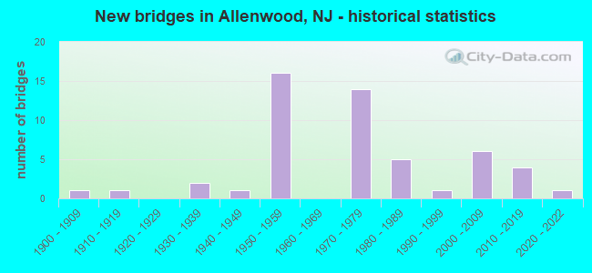
- New bridges - historical statistics
- 11900-1909
- 11910-1919
- 21930-1939
- 11940-1949
- 161950-1959
- 141970-1979
- 51980-1989
- 11990-1999
- 62000-2009
- 42010-2019
- 12020-2022
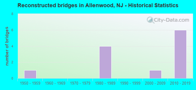
- Reconstructed bridges - Historical Statistics
- 11950-1959
- 01960-1969
- 01970-1979
- 41980-1989
- 01990-1999
- 12000-2009
- 62010-2019

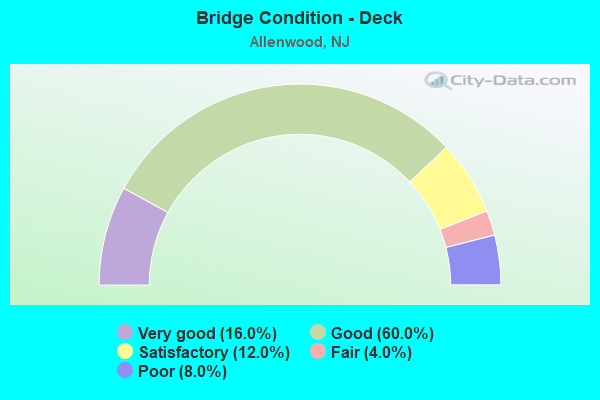
- Bridge Condition - Deck
- 16.0%Very good
- 60.0%Good
- 12.0%Satisfactory
- 4.0%Fair
- 8.0%Poor
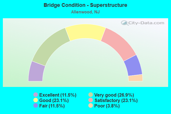
- Bridge Condition - Superstructure
- 11.5%Excellent
- 26.9%Very good
- 23.1%Good
- 23.1%Satisfactory
- 11.5%Fair
- 3.8%Poor
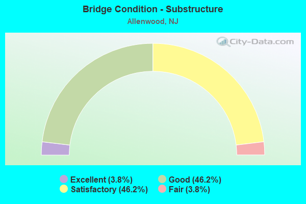
- Bridge Condition - Substructure
- 3.8%Excellent
- 46.2%Good
- 46.2%Satisfactory
- 3.8%Fair
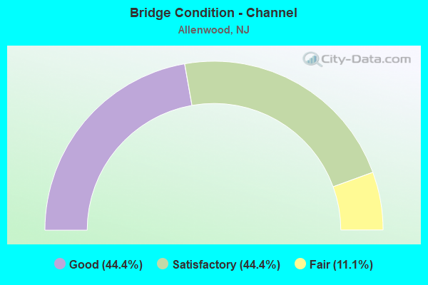
- Bridge Condition - Channel
- 44.4%Good
- 44.4%Satisfactory
- 11.1%Fair
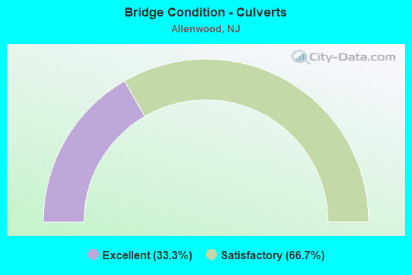
- Bridge Condition - Culverts
- 33.3%Excellent
- 66.7%Satisfactory
Find on map >> Show street view
Structure Number: 13000W2, Location: 1.18 miles N. of CR 549 (Lat: 40.143331, Lng: -74.117219), Route carried "on" structure: Other road , Year Built: 1982, Status: Open, Structure Length: 2.90m (9.51ft), Average Daily Traffic: 5,560 (year 2021), Truck Traffic: 3%, Average Future Daily Traffic: 6,785 (year 2041), Design Load: HS 20+Mod, Features Intersected: MANASQUAN RIVER, Facility Carried by Structure: HOSPITAL ROAD
Minimum Vertical Clearance: 30+ m (98+ ft), Kilometerpoint: 0.000, Lanes on structure: 2, Owner: County Highway Agency, Approaching Roadway Width: 7.9m (25.9ft), Material/Design: Prestressed concrete, Design/Construction: Box Beam or Girders - Multiple, Number Of Spans In Main Unit: 3, Length of Maximum Span: 9.1m (29.9ft), Curb or Sidewalk Widths: Left: 1.5m (4.9ft), Right: 0.6m (2.0ft), Curb-To-Curb Width: 7.9m (25.9ft), Out-to-Out Width: 10.1m (33.1ft)
Condition: Deck: Good, Superstructure: Good, Substructure: Satisfactory, Channel: Satisfactory, Operating Rating: 56.2 metric tons, Method Used To Determine Operating Rating: Load Factor (LF), Inventory Rating: 33.6 metric tons, Method Used To Determine Inventory Rating: Load Factor (LF), Structural Evaluation: Equal to present minimum criteria, Deck Geometry: High priority of replacement, Waterway Adequacy: Equal to present desirable criteria, Approach Roadway Alignment: Equal to present desirable criteria, Length Of Structure Improvement: 2.90m (9.51ft), Designated Inspection Frequency: Every 24 months, Underwater Inspection Frequency: Every 48 months, Inspection Date: May 2021, Underwater Inspection Date: July 2021, Bridge Improvement Cost: $907,000, Roadway Improvement Cost: $165,000, Total Project Cost: $1,441,000 ( Estimate for 2021), Deck Structure Type: Concrete Cast-file-Place
Find on map >> Show street view
Structure Number: 13000W3, Location: 1.08 miles south of NJ34. (Lat: 40.136981, Lng: -74.107989), Route carried "on" structure: County highway 21, Year Built: 1900, Year Reconstructed: 1992, Status: Open, Structure Length: 5.61m (18.41ft), Average Daily Traffic: 4,795 (year 2021), Truck Traffic: 1%, Average Future Daily Traffic: 5,851 (year 2041), Features Intersected: MANASQUAN RIVER, Facility Carried by Structure: ALLENWD-LAKEWD.RD.
Minimum Vertical Clearance: 30+ m (98+ ft), Kilometerpoint: 11.909, Lanes on structure: 2, Owner: County Highway Agency, Approaching Roadway Width: 7.0m (23.0ft), Navigation Control: Yes ( Vertical Clearance: 1.5m (4.9ft), Horizontal Clearance: 18.3m (60.0ft)), Material/Design: Steel, Design/Construction: Truss - Thru, Number Of Spans In Main Unit: 2, Length of Maximum Span: 27.1m (88.9ft), Curb-To-Curb Width: 7.1m (23.3ft), Out-to-Out Width: 7.6m (24.9ft)
Condition: Deck: Poor, Superstructure: Satisfactory, Substructure: Satisfactory, Channel: Satisfactory, Operating Rating: 51.7 metric tons, Method Used To Determine Operating Rating: Load Factor (LF), Inventory Rating: 30.8 metric tons, Method Used To Determine Inventory Rating: Load Factor (LF), Structural Evaluation: Equal to present minimum criteria, Deck Geometry: High priority of replacement, Waterway Adequacy: Equal to present minimum criteria, Approach Roadway Alignment: High priority of corrective action, Length Of Structure Improvement: 6.61m (21.69ft), Designated Inspection Frequency: Every 24 months, Underwater Inspection Frequency: Every 48 months, Inspection Date: May 2021, Underwater Inspection Date: August 2019, Bridge Improvement Cost: $7,202,000, Roadway Improvement Cost: $1,080,000, Total Project Cost: $10,353,000 ( Estimate for 2021), Deck Structure Type: Steel plate, Wearing Surface/Protective System: Wearing Surface: Bituminous
Find on map >> Show street view
Structure Number: 1300W18, Location: 1 ML E OF GRDN ST PRKWY (Lat: 40.177581, Lng: -74.090469), Route carried "on" structure: City street , Year Built: 1915, Year Reconstructed: 1964, Status: Open, Structure Length: 0.79m (2.59ft), Average Daily Traffic: 5,306 (year 2021), Truck Traffic: 4%, Average Future Daily Traffic: 6,474 (year 2041), Features Intersected: WRECK POND BROOK, Facility Carried by Structure: ALLENWOOD ROAD
Minimum Vertical Clearance: 30+ m (98+ ft), Kilometerpoint: 1.593, Lanes on structure: 2, Owner: County Highway Agency, Approaching Roadway Width: 7.9m (25.9ft), Material/Design: Steel, Design/Construction: Stringer/Multi-beam, Number Of Spans In Main Unit: 1, Length of Maximum Span: 7.0m (23.0ft), Curb-To-Curb Width: 7.8m (25.6ft), Out-to-Out Width: 7.9m (25.9ft)
Condition: Deck: Poor, Superstructure: Poor, Substructure: Satisfactory, Channel: Good, Operating Rating: 29.0 metric tons, Method Used To Determine Operating Rating: Load Factor (LF), Inventory Rating: 17.2 metric tons, Method Used To Determine Inventory Rating: Load Factor (LF), Structural Evaluation: Meets minimum limits, Deck Geometry: High priority of replacement, Waterway Adequacy: Better than present minimum criteria, Approach Roadway Alignment: Equal to present desirable criteria, Length Of Structure Improvement: 0.79m (2.59ft), Designated Inspection Frequency: Every 24 months, Underwater Inspection Frequency: Every 24 months, Inspection Date: May 2021, Underwater Inspection Date: June 2021, Bridge Improvement Cost: $463,000, Roadway Improvement Cost: $319,000, Total Project Cost: $1,109,000 ( Estimate for 2021), Deck Structure Type: Concrete Cast-file-Place, Wearing Surface/Protective System: Wearing Surface: Bituminous
Find on map >> Show street view
Structure Number: 130715, Location: 1.6 MILE NORTH OF 35 JCT (Lat: 40.135811, Lng: -74.089989), Route carried "on" structure: State highway 34, Year Built: 2021, Status: Open, Structure Length: 4.36m (14.30ft), Average Daily Traffic: 41,125 (year 2021), Truck Traffic: 4%, Average Future Daily Traffic: 49,870 (year 2041), Design Load: HL 93, Features Intersected: Frmr Freehol&Jamesbrg RR
Minimum Vertical Clearance: 30+ m (98+ ft), Kilometerpoint: 2.607, Lanes on structure: 4, Base Highway Network: Yes, Owner: State Highway Agency, Approaching Roadway Width: 29.5m (96.8ft), Skew: 24 degrees, Material/Design: Concrete, Design/Construction: Culvert, Number Of Spans In Main Unit: 1, Length of Maximum Span: 7.3m (24.0ft)
Condition: Culverts: Excellent, Operating Rating: 42.1 metric tons, Method Used To Determine Operating Rating: Assigned ratings based on Load and Resistance Factor Design (LRFD) reported by rating factor (RF) using HL93 loadings, Inventory Rating: 32.4 metric tons, Method Used To Determine Inventory Rating: Assigned ratings based on Load and Resistance Factor Design (LRFD) reported by rating factor (RF) using HL93 loadings, Structural Evaluation: Equal to present desirable criteria, Approach Roadway Alignment: Equal to present minimum criteria, Designated Inspection Frequency: Every 24 months, Inspection Date: September 2021, Bridge Improvement Cost: $2,247,000, Roadway Improvement Cost: $225,000, Total Project Cost: $2,842,000 ( Estimate for 2020), Wearing Surface/Protective System: Wearing Surface: Bituminous
Find on map >> Show street view
Structure Number: 1307151, Location: 2.16 MILES S OF I-195 JCT (Lat: 40.140769, Lng: -74.092050), Route carried "on" structure: State highway 34, Year Built: 1936, Status: Open, Structure Length: 2.01m (6.59ft), Average Daily Traffic: 38,657 (year 2020), Truck Traffic: 4%, Average Future Daily Traffic: 47,169 (year 2040), Features Intersected: ATLANTIC AVE (524 SPUR)
Minimum Vertical Clearance: 30+ m (98+ ft), Kilometerpoint: 3.170, Lanes on structure: 4, Lanes under structure: 2, Base Highway Network: Yes, Owner: State Highway Agency, Approaching Roadway Width: 16.5m (54.1ft), Skew: 22 degrees, Material/Design: Steel, Design/Construction: Stringer/Multi-beam, Number Of Spans In Main Unit: 1, Length of Maximum Span: 18.6m (61.0ft), Curb or Sidewalk Widths: Left: 1.9m (6.2ft), Right: 0.4m (1.3ft), Curb-To-Curb Width: 16.5m (54.1ft), Out-to-Out Width: 19.5m (64.0ft)
Condition: Deck: Fair, Superstructure: Fair, Substructure: Satisfactory, Operating Rating: 55.3 metric tons, Method Used To Determine Operating Rating: Load Factor (LF), Inventory Rating: 32.7 metric tons, Method Used To Determine Inventory Rating: Load Factor (LF), Structural Evaluation: Somewhat better than minimum adequacy, Deck Geometry: Meets minimum limits, Underclear: Meets minimum limits, Approach Roadway Alignment: Better than present minimum criteria, Designated Inspection Frequency: Every 24 months, Inspection Date: June 2020, Deck Structure Type: Concrete Cast-file-Place, Wearing Surface/Protective System: Wearing Surface: Bituminous
Find on map >> Show street view
Structure Number: 1307155, Location: AT JCT WITH I-195 (Lat: 40.169781, Lng: -74.106100), Route carried "on" structure: State highway 34, Year Built: 1974, Status: Open, Structure Length: 5.46m (17.91ft), Average Daily Traffic: 32,995 (year 2020), Truck Traffic: 4%, Average Future Daily Traffic: 40,297 (year 2040), Design Load: HS 20, Features Intersected: I-195 & NJ 138
Minimum Vertical Clearance: 30+ m (98+ ft), Kilometerpoint: 6.647, Lanes on structure: 6, Lanes under structure: 6, Base Highway Network: Yes, Owner: State Highway Agency, Approaching Roadway Width: 24.4m (80.1ft), Skew: 22 degrees, Material/Design: Steel, Design/Construction: Stringer/Multi-beam, Number Of Spans In Main Unit: 2, Length of Maximum Span: 26.5m (86.9ft), Curb or Sidewalk Widths: Left: 1.8m (5.9ft), Right: 1.8m (5.9ft), Curb-To-Curb Width: 24.4m (80.1ft), Out-to-Out Width: 34.7m (113.8ft)
Condition: Deck: Satisfactory, Superstructure: Satisfactory, Substructure: Satisfactory, Inventory Rating: 54.4 metric tons, Method Used To Determine Inventory Rating: Load Factor (LF), Structural Evaluation: Equal to present minimum criteria, Deck Geometry: Somewhat better than minimum adequacy, Underclear: High priority of corrective action, Approach Roadway Alignment: Equal to present desirable criteria, Length Of Structure Improvement: 5.46m (17.91ft), Designated Inspection Frequency: Every 24 months, Inspection Date: September 2020, Bridge Improvement Cost: $904,000, Roadway Improvement Cost: $136,000, Total Project Cost: $1,293,000 ( Estimate for 2020), Deck Structure Type: Concrete Cast-file-Place, Wearing Surface/Protective System: Wearing Surface: Monolithic Concrete
Find on map >> Show street view
Structure Number: 131715, Location: 0.4 MI W RTS 138 & 18 JCT (Lat: 40.171669, Lng: -74.078331), Route carried "on" structure: State highway 138, Year Built: 1941, Status: Open, Structure Length: 0.73m (2.40ft), Average Daily Traffic: 27,380 (year 2021), Truck Traffic: 5%, Average Future Daily Traffic: 32,856 (year 2041), Features Intersected: N BRANCH WRECK POND
Minimum Vertical Clearance: 30+ m (98+ ft), Kilometerpoint: 2.350, Lanes on structure: 4, Base Highway Network: Yes, Owner: State Highway Agency, Approaching Roadway Width: 24.4m (80.1ft), Skew: 21 degrees, Material/Design: Concrete, Design/Construction: Slab, Number Of Spans In Main Unit: 1, Length of Maximum Span: 6.7m (22.0ft), Curb-To-Curb Width: 24.4m (80.1ft), Out-to-Out Width: 36.0m (118.1ft)
Condition: Superstructure: Good, Substructure: Fair, Channel: Satisfactory, Operating Rating: 53.5 metric tons, Method Used To Determine Operating Rating: Load Factor (LF), Inventory Rating: 31.8 metric tons, Method Used To Determine Inventory Rating: Load Factor (LF), Structural Evaluation: Somewhat better than minimum adequacy, Deck Geometry: Superior to present desirable criteria, Waterway Adequacy: Somewhat better than minimum adequacy, Approach Roadway Alignment: Equal to present desirable criteria, Designated Inspection Frequency: Every 24 months, Inspection Date: June 2021
Find on map >> Show street view
Structure Number: 1317152, Location: 0.27 MI EAST OF RT 34 (Lat: 40.170019, Lng: -74.101481), Route carried "on" structure: State highway 138, Year Built: 1974, Status: Open, Structure Length: 5.49m (18.01ft), Average Daily Traffic: 24,134 (year 2021), Truck Traffic: 5%, Average Future Daily Traffic: 28,961 (year 2041), Design Load: HS 20+Mod, Features Intersected: GSP SB AND RAMPS A,D & J
Minimum Vertical Clearance: 30+ m (98+ ft), Kilometerpoint: 0.451, Lanes on structure: 3, Lanes under structure: 6, Base Highway Network: Yes, Owner: State Highway Agency, Approaching Roadway Width: 12.8m (42.0ft), Skew: 1 degrees, Material/Design: Steel, Design/Construction: Stringer/Multi-beam, Number Of Spans In Main Unit: 2, Length of Maximum Span: 33.5m (109.9ft), Curb or Sidewalk Widths: Left: 0.2m (0.7ft), Right: 1.8m (5.9ft), Curb-To-Curb Width: 12.9m (42.3ft), Out-to-Out Width: 15.5m (50.9ft)
Condition: Deck: Good, Superstructure: Satisfactory, Substructure: Satisfactory, Inventory Rating: 61.7 metric tons, Method Used To Determine Inventory Rating: Load Factor (LF), Structural Evaluation: Equal to present minimum criteria, Deck Geometry: High priority of replacement, Underclear: Equal to present minimum criteria, Approach Roadway Alignment: Equal to present desirable criteria, Length Of Structure Improvement: 5.49m (18.01ft), Designated Inspection Frequency: Every 24 months, Inspection Date: April 2021, Bridge Improvement Cost: $47,000, Roadway Improvement Cost: $12,000, Total Project Cost: $65,000 ( Estimate for 2021), Deck Structure Type: Concrete Cast-file-Place, Wearing Surface/Protective System: Wearing Surface: Monolithic Concrete
Find on map >> Show street view
Structure Number: 1317154, Location: 0.35 EAST OF RT 34 (Lat: 40.170081, Lng: -74.099919), Route carried "on" structure: State highway 138, Year Built: 1974, Status: Open, Structure Length: 5.94m (19.49ft), Average Daily Traffic: 24,134 (year 2021), Truck Traffic: 5%, Average Future Daily Traffic: 28,961 (year 2041), Design Load: HS 20+Mod, Features Intersected: GSP NB & RAMPS F & I
Minimum Vertical Clearance: 30+ m (98+ ft), Kilometerpoint: 0.579, Lanes on structure: 3, Lanes under structure: 7, Base Highway Network: Yes, Owner: State Highway Agency, Approaching Roadway Width: 12.8m (42.0ft), Skew: 1 degrees, Material/Design: Steel, Design/Construction: Stringer/Multi-beam, Number Of Spans In Main Unit: 2, Length of Maximum Span: 36.6m (120.1ft), Curb or Sidewalk Widths: Left: 0.2m (0.7ft), Right: 1.8m (5.9ft), Curb-To-Curb Width: 12.9m (42.3ft), Out-to-Out Width: 15.5m (50.9ft)
Condition: Deck: Good, Superstructure: Good, Substructure: Satisfactory, Inventory Rating: 60.8 metric tons, Method Used To Determine Inventory Rating: Load Factor (LF), Structural Evaluation: Equal to present minimum criteria, Deck Geometry: High priority of replacement, Underclear: Equal to present minimum criteria, Approach Roadway Alignment: Better than present minimum criteria, Length Of Structure Improvement: 5.94m (19.49ft), Designated Inspection Frequency: Every 24 months, Inspection Date: April 2021, Bridge Improvement Cost: $47,000, Roadway Improvement Cost: $12,000, Total Project Cost: $59,000 ( Estimate for 2021), Deck Structure Type: Concrete Cast-file-Place, Wearing Surface/Protective System: Wearing Surface: Monolithic Concrete
Find on map >> Show street view
Structure Number: 1506016, Location: 1.7 MI NORTH EXIT 90 GSP (Lat: 40.114200, Lng: -74.123111), Route carried "on" structure: County highway 549, Year Built: 1979, Status: Open, Structure Length: 0.76m (2.49ft), Average Daily Traffic: 6,395 (year 2020), Truck Traffic: 4%, Average Future Daily Traffic: 7,800 (year 2020), Design Load: HS 20+Mod, Features Intersected: SAWMILL CREEK
Minimum Vertical Clearance: 30+ m (98+ ft), Kilometerpoint: 22.563, Lanes on structure: 2, Owner: County Highway Agency, Approaching Roadway Width: 12.2m (40.0ft), Skew: 3 degrees, Material/Design: Concrete, Design/Construction: Culvert, Number Of Spans In Main Unit: 1, Length of Maximum Span: 6.7m (22.0ft), Curb or Sidewalk Widths: Left: 1.2m (3.9ft), Right: 0.3m (1.0ft), Curb-To-Curb Width: 12.3m (40.4ft), Out-to-Out Width: 14.3m (46.9ft)
Condition: Channel: Good, Culverts: Satisfactory, Operating Rating: 73.5 metric tons, Method Used To Determine Operating Rating: Load Factor (LF), Inventory Rating: 43.5 metric tons, Method Used To Determine Inventory Rating: Load Factor (LF), Structural Evaluation: Equal to present minimum criteria, Deck Geometry: Somewhat better than minimum adequacy, Waterway Adequacy: Superior to present desirable criteria, Approach Roadway Alignment: Equal to present desirable criteria, Designated Inspection Frequency: Every 24 months, Inspection Date: April 2020
Find on map >> Show street view
Structure Number: 1506018, Location: 0.9 mi E of RT 549 (Lat: 40.109600, Lng: -74.117239), Route carried "on" structure: City street , Year Built: 1975, Status: Open, Structure Length: 0.73m (2.40ft), Average Daily Traffic: 6,765 (year 2020), Truck Traffic: 3%, Average Future Daily Traffic: 8,255 (year 2040), Design Load: HS 20+Mod, Features Intersected: SAWMILL CREEK, Facility Carried by Structure: LANES MILL RD
Minimum Vertical Clearance: 30+ m (98+ ft), Kilometerpoint: 1.448, Lanes on structure: 2, Owner: County Highway Agency, Approaching Roadway Width: 14.0m (45.9ft), Skew: 3 degrees, Material/Design: Concrete, Design/Construction: Culvert, Number Of Spans In Main Unit: 1, Length of Maximum Span: 7.3m (24.0ft), Curb or Sidewalk Widths: Left: 1.2m (3.9ft), Right: 1.2m (3.9ft), Curb-To-Curb Width: 14.0m (45.9ft), Out-to-Out Width: 17.1m (56.1ft)
Condition: Channel: Satisfactory, Culverts: Satisfactory, Inventory Rating: 56.2 metric tons, Method Used To Determine Inventory Rating: Load Factor (LF), Structural Evaluation: Equal to present minimum criteria, Deck Geometry: Superior to present desirable criteria, Waterway Adequacy: Superior to present desirable criteria, Approach Roadway Alignment: Equal to present desirable criteria, Designated Inspection Frequency: Every 24 months, Inspection Date: April 2020
Find on map >> Show street view
Structure Number: 3490001, Location: 0.6MI SW OF RT524&30 JCT (Lat: 40.151000, Lng: -74.126881), Route carried "on" structure: State lands road , Year Built: 1995, Status: Open, Structure Length: 2.13m (6.99ft), Average Daily Traffic: 11 (year 2021), Truck Traffic: 1%, Average Future Daily Traffic: 13 (year 2041), Features Intersected: MANASQUAN RIVER, Facility Carried by Structure: GOLF COURSE BRIDGE
Minimum Vertical Clearance: 30+ m (98+ ft), Kilometerpoint: 0.000, Lanes on structure: 1, Owner: State Agenciy, Approaching Roadway Width: 4.9m (16.1ft), Material/Design: Steel, Design/Construction: Truss - Thru, Number Of Spans In Main Unit: 1, Length of Maximum Span: 21.3m (69.9ft), Curb-To-Curb Width: 4.7m (15.4ft), Out-to-Out Width: 5.2m (17.1ft)
Condition: Deck: Good, Superstructure: Good, Substructure: Good, Channel: Good, Operating Rating: 44.5 metric tons, Method Used To Determine Operating Rating: Field evaluation and documented engineering judgment, Inventory Rating: 32.7 metric tons, Method Used To Determine Inventory Rating: Field evaluation and documented engineering judgment, Structural Evaluation: Better than present minimum criteria, Deck Geometry: Better than present minimum criteria, Waterway Adequacy: Better than present minimum criteria, Approach Roadway Alignment: Better than present minimum criteria, Designated Inspection Frequency: Every 24 months, Critical Feature Inspection Frequency: Every 24 months, Inspection Date: October 2021, Critical Feature Inspection Date: October 2021, Bridge Improvement Cost: $245,000, Roadway Improvement Cost: $20,000, Total Project Cost: $342,000 ( Estimate for 2015), Deck Structure Type: Wood or Timber
Find on map >> Show street view
Structure Number: 360948N, Location: 1 MI S OF MANASQUAN RIVER (Lat: 40.126478, Lng: -74.125567), Route carried "on" structure: Other road GSP, Year Built: 1954, Year Reconstructed: 2015, Status: Open, Structure Length: 1.62m (5.31ft), Average Daily Traffic: 65,700 (year 2021), Truck Traffic: 3%, Average Future Daily Traffic: 80,150 (year 2041), Design Load: HL 93, Features Intersected: HERBERTSVILLE RD (549)
Minimum Vertical Clearance: 30+ m (98+ ft), Kilometerpoint: 152.614, Lanes on structure: 4, Lanes under structure: 2, Base Highway Network: Yes, Toll: On toll road, Owner: State Toll Authority, Approaching Roadway Width: 22.1m (72.5ft), Skew: 2 degrees, Material/Design: Steel, Design/Construction: Stringer/Multi-beam, Number Of Spans In Main Unit: 1, Length of Maximum Span: 14.6m (47.9ft), Curb-To-Curb Width: 22.1m (72.5ft), Out-to-Out Width: 23.2m (76.1ft)
Condition: Deck: Good, Superstructure: Very good, Substructure: Good, Operating Rating: 50.5 metric tons, Method Used To Determine Operating Rating: Load and Resistance Factor Rating (LRFR) rating reported by rating factor(RF) method using HL-93 loadings, Inventory Rating: 38.9 metric tons, Method Used To Determine Inventory Rating: Load and Resistance Factor Rating (LRFR) rating reported by rating factor(RF) method using HL-93 loadings, Structural Evaluation: Better than present minimum criteria, Deck Geometry: Equal to present desirable criteria, Underclear: Meets minimum limits, Approach Roadway Alignment: Equal to present desirable criteria, Length Of Structure Improvement: 3.32m (10.89ft), Designated Inspection Frequency: Every 24 months, Inspection Date: May 2021, Bridge Improvement Cost: $200,000, Roadway Improvement Cost: $100,000, Total Project Cost: $800,000 ( Estimate for 2015), Deck Structure Type: Concrete Cast-file-Place, Wearing Surface/Protective System: Wearing Surface: Monolithic Concrete, Deck Protection: Epoxy Coated Reinforcing
Find on map >> Show street view
Structure Number: 360949S, Location: 0.6 MI S of MANASQUAN R. (Lat: 40.126897, Lng: -74.126028), Route carried "on" structure: Other road GSP, Year Built: 1954, Year Reconstructed: 2015, Status: Open, Structure Length: 1.62m (5.31ft), Average Daily Traffic: 66,800 (year 2021), Truck Traffic: 3%, Average Future Daily Traffic: 81,500 (year 2041), Design Load: HL 93, Features Intersected: HERBERTSVILLE RD (549)
Minimum Vertical Clearance: 30+ m (98+ ft), Kilometerpoint: 152.614, Lanes on structure: 4, Lanes under structure: 2, Base Highway Network: Yes, Toll: On toll road, Owner: State Toll Authority, Approaching Roadway Width: 22.6m (74.1ft), Skew: 2 degrees, Material/Design: Steel, Design/Construction: Stringer/Multi-beam, Number Of Spans In Main Unit: 1, Length of Maximum Span: 14.3m (46.9ft), Curb-To-Curb Width: 22.6m (74.1ft), Out-to-Out Width: 23.8m (78.1ft)
Condition: Deck: Good, Superstructure: Excellent, Substructure: Good, Operating Rating: 45.7 metric tons, Method Used To Determine Operating Rating: Load and Resistance Factor Rating (LRFR) rating reported by rating factor(RF) method using HL-93 loadings, Inventory Rating: 35.3 metric tons, Method Used To Determine Inventory Rating: Load and Resistance Factor Rating (LRFR) rating reported by rating factor(RF) method using HL-93 loadings, Structural Evaluation: Better than present minimum criteria, Deck Geometry: Superior to present desirable criteria, Underclear: Meets minimum limits, Approach Roadway Alignment: Equal to present desirable criteria, Designated Inspection Frequency: Every 24 months, Inspection Date: May 2021, Deck Structure Type: Concrete Cast-file-Place, Wearing Surface/Protective System: Wearing Surface: Monolithic Concrete, Deck Protection: Epoxy Coated Reinforcing
Find on map >> Show street view
Structure Number: 360954N, Location: 3.4 MI N OF RTS70&88 CIR (Lat: 40.132661, Lng: -74.119831), Route carried "on" structure: Other road GSP, Year Built: 1953, Year Reconstructed: 2015, Status: Open, Structure Length: 1.52m (4.99ft), Average Daily Traffic: 62,950 (year 2021), Truck Traffic: 3%, Average Future Daily Traffic: 76,800 (year 2041), Design Load: HL 93, Features Intersected: SQUANKUM RD (CR 21)
Minimum Vertical Clearance: 30+ m (98+ ft), Kilometerpoint: 153.451, Lanes on structure: 4, Lanes under structure: 2, Base Highway Network: Yes, Toll: On toll road, Owner: State Toll Authority, Approaching Roadway Width: 22.3m (73.2ft), Skew: 1 degrees, Material/Design: Steel, Design/Construction: Stringer/Multi-beam, Number Of Spans In Main Unit: 1, Length of Maximum Span: 15.2m (49.9ft), Curb-To-Curb Width: 22.3m (73.2ft), Out-to-Out Width: 23.4m (76.8ft)
Condition: Deck: Very good, Superstructure: Excellent, Substructure: Good, Operating Rating: 52.2 metric tons, Method Used To Determine Operating Rating: Load and Resistance Factor Rating (LRFR) rating reported by rating factor(RF) method using HL-93 loadings, Inventory Rating: 40.2 metric tons, Method Used To Determine Inventory Rating: Load and Resistance Factor Rating (LRFR) rating reported by rating factor(RF) method using HL-93 loadings, Structural Evaluation: Better than present minimum criteria, Deck Geometry: Superior to present desirable criteria, Underclear: Meets minimum limits, Approach Roadway Alignment: Equal to present desirable criteria, Designated Inspection Frequency: Every 24 months, Inspection Date: May 2021, Deck Structure Type: Concrete Cast-file-Place, Wearing Surface/Protective System: Wearing Surface: Monolithic Concrete, Deck Protection: Epoxy Coated Reinforcing
Find on map >> Show street view
Structure Number: 360954S, Location: 3.4 MI N OF RTS70&88 CIR (Lat: 40.132883, Lng: -74.120483), Route carried "on" structure: Other road GSP, Year Built: 1953, Year Reconstructed: 2015, Status: Open, Structure Length: 1.52m (4.99ft), Average Daily Traffic: 62,950 (year 2021), Truck Traffic: 3%, Average Future Daily Traffic: 76,800 (year 2041), Design Load: HL 93, Features Intersected: SQUANKUM ROAD (CR 21)
Minimum Vertical Clearance: 30+ m (98+ ft), Kilometerpoint: 153.451, Lanes on structure: 4, Lanes under structure: 2, Base Highway Network: Yes, Toll: On toll road, Owner: State Toll Authority, Approaching Roadway Width: 22.6m (74.1ft), Skew: 2 degrees, Material/Design: Steel, Design/Construction: Stringer/Multi-beam, Number Of Spans In Main Unit: 1, Length of Maximum Span: 14.0m (45.9ft), Curb-To-Curb Width: 22.6m (74.1ft), Out-to-Out Width: 23.8m (78.1ft)
Condition: Deck: Good, Superstructure: Excellent, Substructure: Good, Operating Rating: 64.5 metric tons, Method Used To Determine Operating Rating: Load and Resistance Factor Rating (LRFR) rating reported by rating factor(RF) method using HL-93 loadings, Inventory Rating: 49.6 metric tons, Method Used To Determine Inventory Rating: Load and Resistance Factor Rating (LRFR) rating reported by rating factor(RF) method using HL-93 loadings, Structural Evaluation: Better than present minimum criteria, Deck Geometry: Superior to present desirable criteria, Underclear: Meets minimum limits, Approach Roadway Alignment: Equal to present desirable criteria, Designated Inspection Frequency: Every 24 months, Inspection Date: May 2021, Deck Structure Type: Concrete Cast-file-Place, Wearing Surface/Protective System: Wearing Surface: Monolithic Concrete, Deck Protection: Epoxy Coated Reinforcing
Find on map >> Show street view
Structure Number: 360967N, Location: 0.93 MI S OF GSP&NJ34 JCT (Lat: 40.149069, Lng: -74.106444), Route carried "on" structure: County highway 524, Year Built: 1983, Status: Open, Structure Length: 4.75m (15.58ft), Average Daily Traffic: 5,313 (year 2020), Truck Traffic: 3%, Average Future Daily Traffic: 6,380 (year 2040), Design Load: HS 20+Mod, Features Intersected: GSP NB, Facility Carried by Structure: ATLANTIC AVE.
Minimum Vertical Clearance: 30+ m (98+ ft), Kilometerpoint: 57.775, Lanes on structure: 2, Lanes under structure: 4, Owner: State Toll Authority, Approaching Roadway Width: 9.4m (30.8ft), Skew: 3 degrees, Material/Design: Steel, Design/Construction: Stringer/Multi-beam, Number Of Spans In Main Unit: 1, Length of Maximum Span: 45.7m (149.9ft), Curb or Sidewalk Widths: Left: 1.5m (4.9ft), Right: 0.0m, Curb-To-Curb Width: 9.2m (30.2ft), Out-to-Out Width: 11.5m (37.7ft)
Condition: Deck: Good, Superstructure: Satisfactory, Substructure: Satisfactory, Operating Rating: 71.6 metric tons, Method Used To Determine Operating Rating: Load and Resistance Factor Rating (LRFR) rating reported by rating factor(RF) method using HL-93 loadings, Inventory Rating: 55.4 metric tons, Method Used To Determine Inventory Rating: Load and Resistance Factor Rating (LRFR) rating reported by rating factor(RF) method using HL-93 loadings, Structural Evaluation: Equal to present minimum criteria, Deck Geometry: High priority of corrective action, Underclear: Meets minimum limits, Approach Roadway Alignment: Equal to present minimum criteria, Designated Inspection Frequency: Every 24 months, Inspection Date: May 2020, Bridge Improvement Cost: $400,000, Roadway Improvement Cost: $50,000, Total Project Cost: $500,000 ( Estimate for 2016), Deck Structure Type: Concrete Cast-file-Place, Wearing Surface/Protective System: Wearing Surface: Monolithic Concrete, Deck Protection: Epoxy Coated Reinforcing
Find on map >> Show street view
Structure Number: 360968S, Location: 0.93 MI S OF GSP&NJ34 JCT (Lat: 40.149711, Lng: -74.107089), Route carried "on" structure: County highway 524, Year Built: 1985, Status: Open, Structure Length: 4.75m (15.58ft), Average Daily Traffic: 4,950 (year 2020), Truck Traffic: 3%, Average Future Daily Traffic: 6,960 (year 2040), Design Load: HS 20+Mod, Features Intersected: GSP SB
Minimum Vertical Clearance: 30+ m (98+ ft), Kilometerpoint: 57.775, Lanes on structure: 2, Lanes under structure: 4, Owner: State Toll Authority, Approaching Roadway Width: 9.1m (29.9ft), Skew: 3 degrees, Material/Design: Steel, Design/Construction: Stringer/Multi-beam, Number Of Spans In Main Unit: 1, Length of Maximum Span: 45.7m (149.9ft), Curb or Sidewalk Widths: Left: 1.5m (4.9ft), Right: 0.0m, Curb-To-Curb Width: 9.3m (30.5ft), Out-to-Out Width: 11.5m (37.7ft)
Condition: Deck: Good, Superstructure: Satisfactory, Substructure: Satisfactory, Operating Rating: 71.6 metric tons, Method Used To Determine Operating Rating: Load and Resistance Factor Rating (LRFR) rating reported by rating factor(RF) method using HL-93 loadings, Inventory Rating: 55.4 metric tons, Method Used To Determine Inventory Rating: Load and Resistance Factor Rating (LRFR) rating reported by rating factor(RF) method using HL-93 loadings, Structural Evaluation: Equal to present minimum criteria, Deck Geometry: Meets minimum limits, Underclear: Meets minimum limits, Approach Roadway Alignment: Equal to present minimum criteria, Designated Inspection Frequency: Every 24 months, Inspection Date: May 2020, Deck Structure Type: Concrete Cast-file-Place, Wearing Surface/Protective System: Wearing Surface: Monolithic Concrete, Deck Protection: Epoxy Coated Reinforcing
Find on map >> Show street view
Structure Number: 360976N, Location: 0.55 Mi S of NJ138&GSP JC (Lat: 40.161792, Lng: -74.101975), Route carried "on" structure: Other road GSP, Year Built: 1953, Year Reconstructed: 2015, Status: Open, Structure Length: 7.22m (23.69ft), Average Daily Traffic: 59,696 (year 2020), Truck Traffic: 3%, Average Future Daily Traffic: 72,840 (year 2040), Design Load: H 20, Features Intersected: NJ 34
Minimum Vertical Clearance: 30+ m (98+ ft), Kilometerpoint: 157.152, Lanes on structure: 5, Lanes under structure: 4, Base Highway Network: Yes, Toll: On toll road, Owner: State Toll Authority, Approaching Roadway Width: 25.6m (84.0ft), Skew: 5 degrees, Material/Design: Steel, Design/Construction: Stringer/Multi-beam, Number Of Spans In Main Unit: 2, Length of Maximum Span: 34.4m (112.9ft), Curb-To-Curb Width: 25.6m (84.0ft), Out-to-Out Width: 26.8m (87.9ft)
Condition: Deck: Good, Superstructure: Very good, Substructure: Good, Operating Rating: 44.1 metric tons, Method Used To Determine Operating Rating: Load and Resistance Factor Rating (LRFR) rating reported by rating factor(RF) method using HL-93 loadings, Inventory Rating: 34.0 metric tons, Method Used To Determine Inventory Rating: Load and Resistance Factor Rating (LRFR) rating reported by rating factor(RF) method using HL-93 loadings, Structural Evaluation: Better than present minimum criteria, Deck Geometry: Better than present minimum criteria, Underclear: Equal to present minimum criteria, Approach Roadway Alignment: Equal to present desirable criteria, Designated Inspection Frequency: Every 24 months, Inspection Date: May 2020, Deck Structure Type: Concrete Cast-file-Place, Wearing Surface/Protective System: Wearing Surface: Monolithic Concrete, Deck Protection: Epoxy Coated Reinforcing
Find on map >> Show street view
Structure Number: 360976S, Location: .6 MI S OF NJ38&GSP JCT (Lat: 40.161142, Lng: -74.103142), Route carried "on" structure: Other road GSP, Year Built: 1972, Year Reconstructed: 2016, Status: Open, Structure Length: 2.74m (8.99ft), Average Daily Traffic: 51,285 (year 2020), Truck Traffic: 3%, Average Future Daily Traffic: 62,568 (year 2040), Design Load: HS 20, Features Intersected: SB EXIT RAMP A
Minimum Vertical Clearance: 30+ m (98+ ft), Kilometerpoint: 156.975, Lanes on structure: 4, Lanes under structure: 1, Base Highway Network: Yes, Toll: On toll road, Owner: State Toll Authority, Approaching Roadway Width: 21.9m (71.9ft), Skew: 5 degrees, Material/Design: Steel, Design/Construction: Stringer/Multi-beam, Number Of Spans In Main Unit: 1, Length of Maximum Span: 24.7m (81.0ft), Curb-To-Curb Width: 21.9m (71.9ft), Out-to-Out Width: 23.1m (75.8ft)
Condition: Deck: Good, Superstructure: Very good, Substructure: Good, Operating Rating: 55.1 metric tons, Method Used To Determine Operating Rating: Load and Resistance Factor Rating (LRFR) rating reported by rating factor(RF) method using HL-93 loadings, Inventory Rating: 42.4 metric tons, Method Used To Determine Inventory Rating: Load and Resistance Factor Rating (LRFR) rating reported by rating factor(RF) method using HL-93 loadings, Structural Evaluation: Better than present minimum criteria, Deck Geometry: Better than present minimum criteria, Underclear: Equal to present minimum criteria, Approach Roadway Alignment: Equal to present desirable criteria, Designated Inspection Frequency: Every 24 months, Inspection Date: May 2020, Deck Structure Type: Concrete Cast-file-Place, Wearing Surface/Protective System: Wearing Surface: Monolithic Concrete, Deck Protection: Epoxy Coated Reinforcing
Find on map >> Show street view
Structure Number: 360977A, Location: 0.5MI S OF NJ 38&GSP JCT (Lat: 40.163761, Lng: -74.103031), Route carried "on" structure: Ramp Other road GSP, Year Built: 1953, Year Reconstructed: 1986, Status: Open, Structure Length: 6.83m (22.41ft), Average Daily Traffic: 9,400 (year 2020), Truck Traffic: 3%, Average Future Daily Traffic: 13,271 (year 2040), Design Load: H 20, Features Intersected: NJ 34, Facility Carried by Structure: Parkway Ramp 98SBX
Minimum Vertical Clearance: 30+ m (98+ ft), Kilometerpoint: 156.975, Lanes on structure: 1, Lanes under structure: 4, Toll: On toll road, Owner: State Toll Authority, Approaching Roadway Width: 12.2m (40.0ft), Skew: 5 degrees, Material/Design: Steel, Design/Construction: Stringer/Multi-beam, Number Of Spans In Main Unit: 2, Length of Maximum Span: 32.3m (106.0ft), Curb-To-Curb Width: 12.2m (40.0ft), Out-to-Out Width: 13.4m (44.0ft)
Condition: Deck: Satisfactory, Superstructure: Satisfactory, Substructure: Satisfactory, Operating Rating: 38.2 metric tons, Method Used To Determine Operating Rating: Load and Resistance Factor Rating (LRFR) rating reported by rating factor(RF) method using HL-93 loadings, Inventory Rating: 29.5 metric tons, Method Used To Determine Inventory Rating: Load and Resistance Factor Rating (LRFR) rating reported by rating factor(RF) method using HL-93 loadings, Structural Evaluation: Equal to present minimum criteria, Deck Geometry: Superior to present desirable criteria, Underclear: Equal to present minimum criteria, Approach Roadway Alignment: Superior to present desirable criteria, Designated Inspection Frequency: Every 24 months, Inspection Date: May 2020, Deck Structure Type: Concrete Cast-file-Place, Wearing Surface/Protective System: Wearing Surface: Bituminous, Deck Protection: Epoxy Coated Reinforcing
Find on map >> Show street view
Structure Number: 360977S, Location: 0.52mi S of NJ 138&GSP Jc (Lat: 40.163081, Lng: -74.102692), Route carried "on" structure: Other road GSP, Year Built: 1972, Year Reconstructed: 2014, Status: Open, Structure Length: 7.83m (25.69ft), Average Daily Traffic: 107,232 (year 2020), Truck Traffic: 3%, Average Future Daily Traffic: 130,823 (year 2040), Design Load: HS 20+Mod, Features Intersected: NJ 34
Minimum Vertical Clearance: 30+ m (98+ ft), Kilometerpoint: 157.152, Lanes on structure: 4, Lanes under structure: 4, Base Highway Network: Yes, Toll: On toll road, Owner: State Toll Authority, Approaching Roadway Width: 21.9m (71.9ft), Skew: 5 degrees, Material/Design: Steel, Design/Construction: Stringer/Multi-beam, Number Of Spans In Main Unit: 2, Length of Maximum Span: 38.7m (127.0ft), Curb-To-Curb Width: 21.9m (71.9ft), Out-to-Out Width: 23.1m (75.8ft)
Condition: Deck: Good, Superstructure: Very good, Substructure: Good, Operating Rating: 47.3 metric tons, Method Used To Determine Operating Rating: Load and Resistance Factor Rating (LRFR) rating reported by rating factor(RF) method using HL-93 loadings, Inventory Rating: 36.3 metric tons, Method Used To Determine Inventory Rating: Load and Resistance Factor Rating (LRFR) rating reported by rating factor(RF) method using HL-93 loadings, Structural Evaluation: Better than present minimum criteria, Deck Geometry: Better than present minimum criteria, Underclear: Equal to present minimum criteria, Approach Roadway Alignment: Better than present minimum criteria, Designated Inspection Frequency: Every 24 months, Inspection Date: May 2020, Deck Structure Type: Concrete Cast-file-Place, Wearing Surface/Protective System: Wearing Surface: Monolithic Concrete, Deck Protection: Epoxy Coated Reinforcing
Find on map >> Show street view
Structure Number: 360982N, Location: 1.48 Mi w of NJ 18&138JCT (Lat: 40.170100, Lng: -74.099519), Route carried "on" structure: State highway 138, Year Built: 2007, Status: Open, Structure Length: 5.79m (19.00ft), Average Daily Traffic: 22,915 (year 2020), Truck Traffic: 5%, Average Future Daily Traffic: 30,836 (year 2040), Design Load: HS 20, Features Intersected: GSP NB & INT.98 NB RAMP
Minimum Vertical Clearance: 30+ m (98+ ft), Kilometerpoint: 0.579, Lanes on structure: 3, Lanes under structure: 7, Base Highway Network: Yes, Owner: State Toll Authority, Approaching Roadway Width: 16.2m (53.1ft), Skew: 1 degrees, Material/Design: Steel continuous, Design/Construction: Stringer/Multi-beam, Number Of Spans In Main Unit: 2, Length of Maximum Span: 32.0m (105.0ft), Curb-To-Curb Width: 16.2m (53.1ft), Out-to-Out Width: 17.2m (56.4ft)
Condition: Deck: Good, Superstructure: Good, Substructure: Good, Operating Rating: 61.9 metric tons, Method Used To Determine Operating Rating: Load and Resistance Factor Rating (LRFR) rating reported by rating factor(RF) method using HL-93 loadings, Inventory Rating: 47.6 metric tons, Method Used To Determine Inventory Rating: Load and Resistance Factor Rating (LRFR) rating reported by rating factor(RF) method using HL-93 loadings, Structural Evaluation: Better than present minimum criteria, Deck Geometry: Equal to present minimum criteria, Underclear: High priority of corrective action, Approach Roadway Alignment: Equal to present desirable criteria, Designated Inspection Frequency: Every 24 months, Inspection Date: May 2020, Deck Structure Type: Concrete Cast-file-Place, Wearing Surface/Protective System: Wearing Surface: Monolithic Concrete, Deck Protection: Epoxy Coated Reinforcing
Find on map >> Show street view
Structure Number: 360982S, Location: 1.56 Mi W OF NJ 18&138JCT (Lat: 40.170050, Lng: -74.101200), Route carried "on" structure: State highway 138, Year Built: 2007, Status: Open, Structure Length: 5.49m (18.01ft), Average Daily Traffic: 21,860 (year 2020), Truck Traffic: 5%, Average Future Daily Traffic: 30,232 (year 2040), Design Load: HS 20, Features Intersected: GSP SB & INT.98 SB RAMP
Minimum Vertical Clearance: 30+ m (98+ ft), Kilometerpoint: 0.451, Lanes on structure: 3, Lanes under structure: 6, Base Highway Network: Yes, Owner: State Toll Authority, Approaching Roadway Width: 16.2m (53.1ft), Skew: 1 degrees, Material/Design: Steel continuous, Design/Construction: Stringer/Multi-beam, Number Of Spans In Main Unit: 2, Length of Maximum Span: 32.0m (105.0ft), Curb-To-Curb Width: 16.2m (53.1ft), Out-to-Out Width: 17.2m (56.4ft)
Condition: Deck: Good, Superstructure: Good, Substructure: Good, Operating Rating: 59.3 metric tons, Method Used To Determine Operating Rating: Load and Resistance Factor Rating (LRFR) rating reported by rating factor(RF) method using HL-93 loadings, Inventory Rating: 45.7 metric tons, Method Used To Determine Inventory Rating: Load and Resistance Factor Rating (LRFR) rating reported by rating factor(RF) method using HL-93 loadings, Structural Evaluation: Better than present minimum criteria, Deck Geometry: Better than present minimum criteria, Underclear: Equal to present minimum criteria, Approach Roadway Alignment: Equal to present desirable criteria, Designated Inspection Frequency: Every 24 months, Inspection Date: May 2020, Deck Structure Type: Concrete Cast-file-Place, Wearing Surface/Protective System: Wearing Surface: Monolithic Concrete, Deck Protection: Epoxy Coated Reinforcing
Find on map >> Show street view
Structure Number: 360987S, Location: 0.54 Mi N of GSP&NJ138 JC (Lat: 40.177969, Lng: -74.100889), Route carried "on" structure: Other road GSP, Year Built: 1954, Year Reconstructed: 1985, Status: Open, Structure Length: 3.11m (10.20ft), Average Daily Traffic: 68,034 (year 2020), Truck Traffic: 3%, Average Future Daily Traffic: 81,640 (year 2040), Design Load: H 20, Features Intersected: W. HURLEY POND ROAD, Facility Carried by Structure: Parkway S
Minimum Vertical Clearance: 30+ m (98+ ft), Kilometerpoint: 158.955, Lanes on structure: 6, Lanes under structure: 2, Base Highway Network: Yes, Toll: On toll road, Owner: State Toll Authority, Approaching Roadway Width: 30.2m (99.1ft), Skew: 1 degrees, Material/Design: Steel, Design/Construction: Stringer/Multi-beam, Number Of Spans In Main Unit: 3, Length of Maximum Span: 12.8m (42.0ft), Curb-To-Curb Width: 29.3m (96.1ft), Out-to-Out Width: 30.4m (99.7ft)
Condition: Deck: Satisfactory, Superstructure: Fair, Substructure: Satisfactory, Operating Rating: 43.7 metric tons, Method Used To Determine Operating Rating: Load and Resistance Factor Rating (LRFR) rating reported by rating factor(RF) method using HL-93 loadings, Inventory Rating: 33.7 metric tons, Method Used To Determine Inventory Rating: Load and Resistance Factor Rating (LRFR) rating reported by rating factor(RF) method using HL-93 loadings, Structural Evaluation: Somewhat better than minimum adequacy, Deck Geometry: Better than present minimum criteria, Underclear: Meets minimum limits, Approach Roadway Alignment: Better than present minimum criteria, Designated Inspection Frequency: Every 24 months, Inspection Date: May 2020, Deck Structure Type: Concrete Cast-file-Place, Wearing Surface/Protective System: Wearing Surface: Monolithic Concrete, Deck Protection: Epoxy Coated Reinforcing
Find on map >> Show street view
Structure Number: 360988N, Location: 0.54 MI N OF GSP&NJ138 JC (Lat: 40.177861, Lng: -74.099389), Route carried "on" structure: Other road GSP, Year Built: 1953, Year Reconstructed: 1985, Status: Open, Structure Length: 3.11m (10.20ft), Average Daily Traffic: 70,686 (year 2020), Truck Traffic: 3%, Average Future Daily Traffic: 84,823 (year 2040), Design Load: H 20, Features Intersected: W. HURLEY POND ROAD, Facility Carried by Structure: Parkway N
Minimum Vertical Clearance: 30+ m (98+ ft), Kilometerpoint: 158.955, Lanes on structure: 5, Lanes under structure: 2, Base Highway Network: Yes, Toll: On toll road, Owner: State Toll Authority, Approaching Roadway Width: 29.0m (95.1ft), Skew: 1 degrees, Material/Design: Steel, Design/Construction: Stringer/Multi-beam, Number Of Spans In Main Unit: 3, Length of Maximum Span: 12.8m (42.0ft), Curb-To-Curb Width: 29.3m (96.1ft), Out-to-Out Width: 30.4m (99.7ft)
Condition: Deck: Good, Superstructure: Fair, Substructure: Satisfactory, Operating Rating: 37.6 metric tons, Method Used To Determine Operating Rating: Load and Resistance Factor Rating (LRFR) rating reported by rating factor(RF) method using HL-93 loadings, Inventory Rating: 28.8 metric tons, Method Used To Determine Inventory Rating: Load and Resistance Factor Rating (LRFR) rating reported by rating factor(RF) method using HL-93 loadings, Structural Evaluation: Somewhat better than minimum adequacy, Deck Geometry: Superior to present desirable criteria, Underclear: Meets minimum limits, Approach Roadway Alignment: Better than present minimum criteria, Designated Inspection Frequency: Every 24 months, Inspection Date: May 2020, Deck Structure Type: Concrete Cast-file-Place, Wearing Surface/Protective System: Wearing Surface: Monolithic Concrete, Deck Protection: Epoxy Coated Reinforcing
Find on map >> Show street view
Structure Number: 370958S, Location: 2.3 MI S. of RT 34 & 195 (Lat: 40.138089, Lng: -74.114419), Route carried "on" structure: Other road GSP, Year Built: 2015, Status: Open, Structure Length: 5.12m (16.80ft), Average Daily Traffic: 57,936 (year 2021), Truck Traffic: 3%, Average Future Daily Traffic: 70,682 (year 2041), Design Load: HL 93, Features Intersected: MANASQUAN RIVER
Minimum Vertical Clearance: 30+ m (98+ ft), Kilometerpoint: 154.272, Lanes on structure: 4, Base Highway Network: Yes, Toll: On toll road, Owner: State Toll Authority, Approaching Roadway Width: 21.9m (71.9ft), Skew: 1 degrees, Material/Design: Steel, Design/Construction: Stringer/Multi-beam, Number Of Spans In Main Unit: 1, Length of Maximum Span: 33.8m (110.9ft), Curb-To-Curb Width: 21.9m (71.9ft), Out-to-Out Width: 23.1m (75.8ft)
Condition: Deck: Very good, Superstructure: Very good, Substructure: Excellent, Channel: Fair, Operating Rating: 57.0 metric tons, Method Used To Determine Operating Rating: Load and Resistance Factor Rating (LRFR) rating reported by rating factor(RF) method using HL-93 loadings, Inventory Rating: 44.1 metric tons, Method Used To Determine Inventory Rating: Load and Resistance Factor Rating (LRFR) rating reported by rating factor(RF) method using HL-93 loadings, Structural Evaluation: Equal to present desirable criteria, Deck Geometry: Better than present minimum criteria, Waterway Adequacy: Equal to present desirable criteria, Approach Roadway Alignment: Equal to present desirable criteria, Designated Inspection Frequency: Every 24 months, Inspection Date: June 2021, Deck Structure Type: Concrete Cast-file-Place, Wearing Surface/Protective System: Wearing Surface: Monolithic Concrete, Deck Protection: Epoxy Coated Reinforcing
Find on map >> Show street view
Structure Number: 370959N, Location: 2.3 MI S. of RT. 34 & 195 (Lat: 40.137889, Lng: -74.113189), Route carried "on" structure: Other road GSP, Year Built: 2015, Status: Open, Structure Length: 5.36m (17.59ft), Average Daily Traffic: 62,216 (year 2021), Truck Traffic: 3%, Average Future Daily Traffic: 75,904 (year 2041), Design Load: HL 93, Features Intersected: MANASQUAN RIVER
Minimum Vertical Clearance: 30+ m (98+ ft), Kilometerpoint: 154.272, Lanes on structure: 4, Base Highway Network: Yes, Toll: On toll road, Owner: State Toll Authority, Approaching Roadway Width: 21.9m (71.9ft), Skew: 2 degrees, Material/Design: Steel, Design/Construction: Stringer/Multi-beam, Number Of Spans In Main Unit: 1, Length of Maximum Span: 36.0m (118.1ft), Curb-To-Curb Width: 21.9m (71.9ft), Out-to-Out Width: 23.1m (75.8ft)
Condition: Deck: Very good, Superstructure: Very good, Substructure: Good, Channel: Good, Operating Rating: 58.0 metric tons, Method Used To Determine Operating Rating: Load and Resistance Factor Rating (LRFR) rating reported by rating factor(RF) method using HL-93 loadings, Inventory Rating: 44.7 metric tons, Method Used To Determine Inventory Rating: Load and Resistance Factor Rating (LRFR) rating reported by rating factor(RF) method using HL-93 loadings, Structural Evaluation: Better than present minimum criteria, Deck Geometry: Better than present minimum criteria, Waterway Adequacy: Equal to present desirable criteria, Approach Roadway Alignment: Equal to present desirable criteria, Designated Inspection Frequency: Every 24 months, Inspection Date: June 2021, Deck Structure Type: Concrete Cast-file-Place, Wearing Surface/Protective System: Wearing Surface: Monolithic Concrete, Deck Protection: Epoxy Coated Reinforcing
Find on map >> Show street view
Structure Number: 370975N, Location: 0.11 MI S. OF NJ 34 (Lat: 40.160311, Lng: -74.102269), Route carried "on" structure: Other road GSP, Year Built: 2016, Status: Open, Structure Length: 2.26m (7.41ft), Average Daily Traffic: 65,160 (year 2020), Truck Traffic: 3%, Average Future Daily Traffic: 79,495 (year 2040), Design Load: H 20, Features Intersected: SB EXIT RAMP A
Minimum Vertical Clearance: 30+ m (98+ ft), Kilometerpoint: 156.975, Lanes on structure: 5, Lanes under structure: 1, Base Highway Network: Yes, Toll: On toll road, Owner: State Toll Authority, Approaching Roadway Width: 25.6m (84.0ft), Skew: 3 degrees, Material/Design: Steel, Design/Construction: Stringer/Multi-beam, Number Of Spans In Main Unit: 1, Length of Maximum Span: 20.7m (67.9ft), Curb-To-Curb Width: 25.6m (84.0ft), Out-to-Out Width: 26.7m (87.6ft)
Condition: Deck: Very good, Superstructure: Very good, Substructure: Good, Operating Rating: 51.5 metric tons, Method Used To Determine Operating Rating: Load and Resistance Factor Rating (LRFR) rating reported by rating factor(RF) method using HL-93 loadings, Inventory Rating: 39.5 metric tons, Method Used To Determine Inventory Rating: Load and Resistance Factor Rating (LRFR) rating reported by rating factor(RF) method using HL-93 loadings, Structural Evaluation: Better than present minimum criteria, Deck Geometry: Better than present minimum criteria, Underclear: Equal to present minimum criteria, Approach Roadway Alignment: Equal to present desirable criteria, Designated Inspection Frequency: Every 24 months, Inspection Date: May 2020, Deck Structure Type: Concrete Cast-file-Place, Wearing Surface/Protective System: Wearing Surface: Monolithic Concrete, Deck Protection: Epoxy Coated Reinforcing
Find on map >> Show street view
Structure Number: 1307151, Location: 2.16 MILES S OF I-195 JCT (Lat: 40.140769, Lng: -74.092050), Route carried "under" structure: Spur County highway 524, Year Built: 1936, Structure Length: 0. m, Average Daily Traffic: 10,141 (year 2020), Truck Traffic: 4%, Features Intersected: ATLANTIC AVE (524 SPUR), Facility Carried by Structure: NJ ROUTE 34
Minimum Vertical Clearance: 4.30m (14.11ft), Kilometerpoint: 1.400, Lanes on structure: 4, Lanes under structure: 2, Material/Design: Steel, Design/Construction: Stringer/Multi-beam, Length of Maximum Span: 18.6m (61.0ft)
Find on map >> Show street view
Structure Number: 1307155, Location: AT JCT WITH I-195 (Lat: 40.169781, Lng: -74.106100), Route carried "under" structure: Interstate 195, Year Built: 1974, Structure Length: 0. m, Average Daily Traffic: 66,679 (year 2020), Truck Traffic: 9%, Features Intersected: I-195 & NJ 138, Facility Carried by Structure: NJ 34
Minimum Vertical Clearance: 4.62m (15.16ft), Kilometerpoint: 54.991, Lanes on structure: 6, Lanes under structure: 6, Material/Design: Steel, Design/Construction: Stringer/Multi-beam, Length of Maximum Span: 26.5m (86.9ft)
Find on map >> Show street view
Structure Number: 1317152, Location: 0.27 MI EAST OF RT 34 (Lat: 40.170019, Lng: -74.101481), Route carried "under" structure: Other road GSP, Year Built: 1974, Structure Length: 0. m, Average Daily Traffic: 22,032 (year 2021), Truck Traffic: 5%, Features Intersected: GSP SB AND RAMPS A,D & J, Facility Carried by Structure: NJ RT 138 EB
Minimum Vertical Clearance: 5.26m (17.26ft), Kilometerpoint: 158.086, Lanes on structure: 3, Lanes under structure: 4, Material/Design: Steel, Design/Construction: Stringer/Multi-beam, Length of Maximum Span: 33.5m (109.9ft)
Find on map >> Show street view
Structure Number: 1317152, Location: 0.27 MI EAST OF RT 34 (Lat: 40.170019, Lng: -74.101481), Route carried "under" structure: Ramp Other road GSP, Year Built: 1974, Structure Length: 0. m, Average Daily Traffic: 18,319 (year 2021), Truck Traffic: 5%, Features Intersected: GSP SB AND RAMPS A,D & J, Facility Carried by Structure: NJ RT 138 EB
Minimum Vertical Clearance: 5.33m (17.49ft), Kilometerpoint: 158.086, Lanes on structure: 3, Lanes under structure: 2, Material/Design: Steel, Design/Construction: Stringer/Multi-beam, Length of Maximum Span: 33.5m (109.9ft)
Find on map >> Show street view
Structure Number: 1317154, Location: 0.35 EAST OF RT 34 (Lat: 40.170081, Lng: -74.099919), Route carried "under" structure: Other road GSP, Year Built: 1974, Structure Length: 0. m, Average Daily Traffic: 22,736 (year 2021), Truck Traffic: 5%, Features Intersected: GSP NB & RAMPS F & I, Facility Carried by Structure: NJ RT 138 EB
Minimum Vertical Clearance: 5.68m (18.64ft), Kilometerpoint: 158.086, Lanes on structure: 3, Lanes under structure: 4, Material/Design: Steel, Design/Construction: Stringer/Multi-beam, Length of Maximum Span: 36.6m (120.1ft)
Find on map >> Show street view
Structure Number: 1317154, Location: 0.35 EAST OF RT 34 (Lat: 40.170081, Lng: -74.099919), Route carried "under" structure: Ramp Other road GSP, Year Built: 1974, Structure Length: 0. m, Average Daily Traffic: 19,304 (year 2021), Truck Traffic: 5%, Features Intersected: GSP NB & RAMPS F & I, Facility Carried by Structure: NJ RT 138 EB
Minimum Vertical Clearance: 5.92m (19.42ft), Kilometerpoint: 158.086, Lanes on structure: 3, Lanes under structure: 3, Material/Design: Steel, Design/Construction: Stringer/Multi-beam, Length of Maximum Span: 36.6m (120.1ft)
Find on map >> Show street view
Structure Number: 360948N, Location: 1 MI S OF MANASQUAN RIVER (Lat: 40.126478, Lng: -74.125567), Route carried "under" structure: County highway 549, Year Built: 1954, Structure Length: 0. m, Average Daily Traffic: 14,328 (year 2021), Truck Traffic: 4%, Features Intersected: HERBERTSVILLE RD (549), Facility Carried by Structure: GSP NB
Minimum Vertical Clearance: 4.65m (15.26ft), Kilometerpoint: 24.076, Lanes on structure: 4, Lanes under structure: 2, Material/Design: Steel, Design/Construction: Stringer/Multi-beam, Length of Maximum Span: 14.6m (47.9ft)
Find on map >> Show street view
Structure Number: 360949S, Location: 0.6 MI S of MANASQUAN R. (Lat: 40.126897, Lng: -74.126028), Route carried "under" structure: County highway 549, Year Built: 1954, Structure Length: 0. m, Average Daily Traffic: 14,328 (year 2021), Truck Traffic: 4%, Features Intersected: HERBERTSVILLE RD (549), Facility Carried by Structure: GSP SB
Minimum Vertical Clearance: 4.47m (14.67ft), Kilometerpoint: 24.140, Lanes on structure: 4, Lanes under structure: 2, Material/Design: Steel, Design/Construction: Stringer/Multi-beam, Length of Maximum Span: 14.3m (46.9ft)
Find on map >> Show street view
Structure Number: 360954N, Location: 3.4 MI N OF RTS70&88 CIR (Lat: 40.132661, Lng: -74.119831), Route carried "under" structure: County highway 21, Year Built: 1953, Structure Length: 0. m, Average Daily Traffic: 2,913 (year 2021), Truck Traffic: 3%, Features Intersected: SQUANKUM RD (CR 21), Facility Carried by Structure: GSP NB
Minimum Vertical Clearance: 4.44m (14.57ft), Kilometerpoint: 10.573, Lanes on structure: 4, Lanes under structure: 2, Material/Design: Steel, Design/Construction: Stringer/Multi-beam, Length of Maximum Span: 15.2m (49.9ft)
Find on map >> Show street view
Structure Number: 360954S, Location: 3.4 MI N OF RTS70&88 CIR (Lat: 40.132883, Lng: -74.120483), Route carried "under" structure: County highway 21, Year Built: 1953, Structure Length: 0. m, Average Daily Traffic: 2,913 (year 2021), Truck Traffic: 3%, Features Intersected: SQUANKUM ROAD (CR 21), Facility Carried by Structure: GSP SB
Minimum Vertical Clearance: 5.28m (17.32ft), Kilometerpoint: 10.541, Lanes on structure: 4, Lanes under structure: 2, Material/Design: Steel, Design/Construction: Stringer/Multi-beam, Length of Maximum Span: 14.0m (45.9ft)
Find on map >> Show street view
Structure Number: 360967N, Location: 0.93 MI S OF GSP&NJ34 JCT (Lat: 40.149069, Lng: -74.106444), Route carried "under" structure: Other road GSP, Year Built: 1983, Structure Length: 0. m, Average Daily Traffic: 37,330 (year 2020), Truck Traffic: 1%, Features Intersected: GSP NB, Facility Carried by Structure: ATLANTIC AVE.
Minimum Vertical Clearance: 4.67m (15.32ft), Kilometerpoint: 155.656, Lanes on structure: 2, Lanes under structure: 4, Toll: On toll road, Material/Design: Steel, Design/Construction: Stringer/Multi-beam, Length of Maximum Span: 45.7m (149.9ft)
Find on map >> Show street view
Structure Number: 360968S, Location: 0.93 MI S OF GSP&NJ34 JCT (Lat: 40.149711, Lng: -74.107089), Route carried "under" structure: Other road GSP, Year Built: 1985, Structure Length: 0. m, Average Daily Traffic: 57,324 (year 2020), Truck Traffic: 5%, Features Intersected: GSP SB, Facility Carried by Structure: ATLANTIC A (CR524)
Minimum Vertical Clearance: 4.85m (15.91ft), Kilometerpoint: 155.656, Lanes on structure: 2, Lanes under structure: 4, Toll: On toll road, Material/Design: Steel, Design/Construction: Stringer/Multi-beam, Length of Maximum Span: 45.7m (149.9ft)
Find on map >> Show street view
Structure Number: 360976N, Location: 0.55 Mi S of NJ138&GSP JC (Lat: 40.161792, Lng: -74.101975), Route carried "under" structure: State highway 34, Year Built: 1953, Structure Length: 0. m, Average Daily Traffic: 51,479 (year 2020), Truck Traffic: 5%, Features Intersected: NJ 34, Facility Carried by Structure: GSP NB
Minimum Vertical Clearance: 5.03m (16.50ft), Kilometerpoint: 5.665, Lanes on structure: 5, Lanes under structure: 4, Material/Design: Steel, Design/Construction: Stringer/Multi-beam, Length of Maximum Span: 34.4m (112.9ft)
Find on map >> Show street view
Structure Number: 360976S, Location: .6 MI S OF NJ38&GSP JCT (Lat: 40.161142, Lng: -74.103142), Route carried "under" structure: Ramp Other road GSP, Year Built: 1972, Structure Length: 0. m, Average Daily Traffic: 52,304 (year 2020), Truck Traffic: 1%, Features Intersected: SB EXIT RAMP A
Minimum Vertical Clearance: 4.80m (15.75ft), Kilometerpoint: 156.975, Lanes on structure: 4, Lanes under structure: 1, Toll: On toll road, Material/Design: Steel, Design/Construction: Stringer/Multi-beam, Length of Maximum Span: 24.7m (81.0ft)
Find on map >> Show street view
Structure Number: 360977A, Location: 0.5MI S OF NJ 38&GSP JCT (Lat: 40.163761, Lng: -74.103031), Route carried "under" structure: State highway 34, Year Built: 1953, Structure Length: 0. m, Average Daily Traffic: 56,475 (year 2020), Truck Traffic: 4%, Features Intersected: NJ 34, Facility Carried by Structure: Parkway Ramp 98SBX
Minimum Vertical Clearance: 5.52m (18.11ft), Kilometerpoint: 5.906, Lanes on structure: 1, Lanes under structure: 4, Material/Design: Steel, Design/Construction: Stringer/Multi-beam, Length of Maximum Span: 32.3m (106.0ft)
Find on map >> Show street view
Structure Number: 360977S, Location: 0.52mi S of NJ 138&GSP Jc (Lat: 40.163081, Lng: -74.102692), Route carried "under" structure: State highway 34, Year Built: 1972, Structure Length: 0. m, Average Daily Traffic: 55,517 (year 2020), Truck Traffic: 4%, Features Intersected: NJ 34, Facility Carried by Structure: GSP SB
Minimum Vertical Clearance: 4.93m (16.17ft), Kilometerpoint: 5.810, Lanes on structure: 4, Lanes under structure: 4, Material/Design: Steel, Design/Construction: Stringer/Multi-beam, Length of Maximum Span: 38.7m (127.0ft)
Find on map >> Show street view
Structure Number: 360982N, Location: 1.48 Mi w of NJ 18&138JCT (Lat: 40.170100, Lng: -74.099519), Route carried "under" structure: Other road GSP, Year Built: 2007, Structure Length: 0. m, Average Daily Traffic: 34,037 (year 2020), Truck Traffic: 1%, Features Intersected: GSP NB & INT.98 NB RAMP, Facility Carried by Structure: NJ 138 WB
Minimum Vertical Clearance: 7.14m (23.43ft), Kilometerpoint: 158.086, Lanes on structure: 3, Lanes under structure: 4, Toll: Toll bridge, Material/Design: Steel continuous, Design/Construction: Stringer/Multi-beam, Length of Maximum Span: 32.0m (105.0ft)
Find on map >> Show street view
Structure Number: 360982N, Location: 1.48 Mi w of NJ 18&138JCT (Lat: 40.170100, Lng: -74.099519), Route carried "under" structure: Ramp Other road GSP, Year Built: 2007, Structure Length: 0. m, Average Daily Traffic: 10,404 (year 2020), Truck Traffic: 1%, Features Intersected: GSP NB & INT.98 NB RAMP, Facility Carried by Structure: NJ 138 WB
Minimum Vertical Clearance: 7.70m (25.26ft), Kilometerpoint: 158.086, Lanes on structure: 3, Lanes under structure: 3, Toll: On toll road, Material/Design: Steel continuous, Design/Construction: Stringer/Multi-beam, Length of Maximum Span: 32.0m (105.0ft)
Find on map >> Show street view
Structure Number: 360982S, Location: 1.56 Mi W OF NJ 18&138JCT (Lat: 40.170050, Lng: -74.101200), Route carried "under" structure: Other road GSP, Year Built: 2007, Structure Length: 0. m, Average Daily Traffic: 54,470 (year 2020), Truck Traffic: 1%, Features Intersected: GSP SB & INT.98 SB RAMP, Facility Carried by Structure: NJ 138 WB
Minimum Vertical Clearance: 5.31m (17.42ft), Kilometerpoint: 158.086, Lanes on structure: 3, Lanes under structure: 4, Toll: On toll road, Material/Design: Steel continuous, Design/Construction: Stringer/Multi-beam, Length of Maximum Span: 32.0m (105.0ft)
Find on map >> Show street view
Structure Number: 360982S, Location: 1.56 Mi W OF NJ 18&138JCT (Lat: 40.170050, Lng: -74.101200), Route carried "under" structure: Ramp Other road GSP, Year Built: 2007, Structure Length: 0. m, Average Daily Traffic: 10,200 (year 2020), Truck Traffic: 1%, Features Intersected: GSP SB & INT.98 SB RAMP, Facility Carried by Structure: NJ 138 WB
Minimum Vertical Clearance: 5.31m (17.42ft), Kilometerpoint: 158.086, Lanes on structure: 3, Lanes under structure: 2, Toll: On toll road, Material/Design: Steel continuous, Design/Construction: Stringer/Multi-beam, Length of Maximum Span: 32.0m (105.0ft)
Find on map >> Show street view
Structure Number: 360987S, Location: 0.54 Mi N of GSP&NJ138 JC (Lat: 40.177969, Lng: -74.100889), Route carried "under" structure: City street , Year Built: 1954, Structure Length: 0. m, Average Daily Traffic: 2,497 (year 2020), Truck Traffic: 3%, Features Intersected: W. HURLEY POND ROAD, Facility Carried by Structure: Parkway S
Minimum Vertical Clearance: 4.50m (14.76ft), Kilometerpoint: 0.000, Lanes on structure: 6, Lanes under structure: 2, Material/Design: Steel, Design/Construction: Stringer/Multi-beam, Length of Maximum Span: 12.8m (42.0ft)