Bridge Statistics for Alpharetta, Georgia (GA)
Condition, Traffic, Stress, Structural Evaluation, Project Costs
- National Bridge Inventory (NBI) Statistics
- 58Number of bridges
- 669ft / 204mTotal length
- $131,833,000Total costs
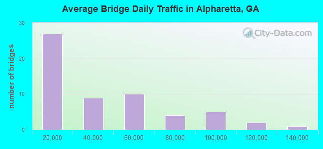
- 2,015,440Total average daily traffic
- 28,817Total average daily truck traffic
- National Bridge Inventory (NBI) Registered Bridges for Alpharetta
- No street view available for this location
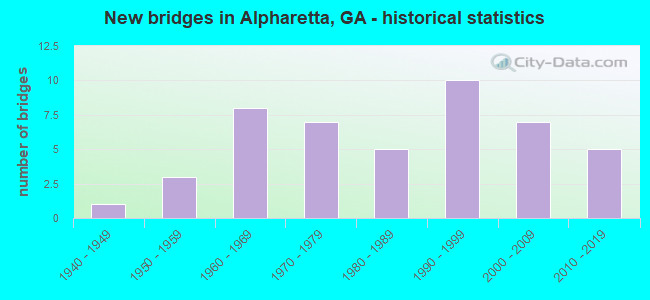
- New bridges - historical statistics
- 11940-1949
- 31950-1959
- 81960-1969
- 71970-1979
- 51980-1989
- 101990-1999
- 72000-2009
- 52010-2019
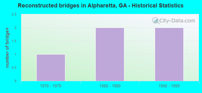
- Reconstructed bridges - Historical Statistics
- 11970-1979
- 21980-1989
- 21990-1999
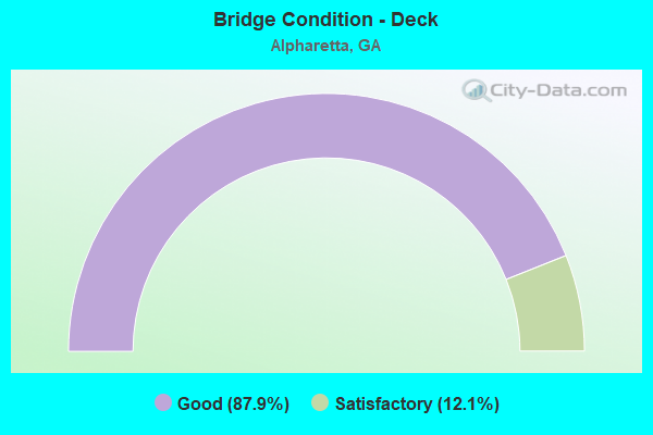
- Bridge Condition - Deck
- 87.9%Good
- 12.1%Satisfactory
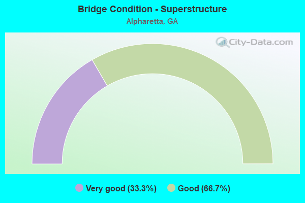
- Bridge Condition - Superstructure
- 33.3%Very good
- 66.7%Good
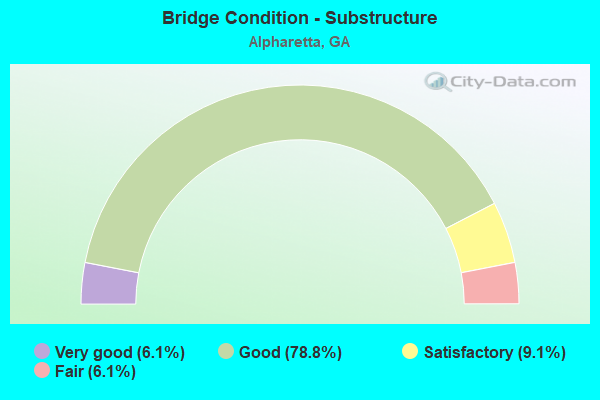
- Bridge Condition - Substructure
- 6.1%Very good
- 78.8%Good
- 9.1%Satisfactory
- 6.1%Fair
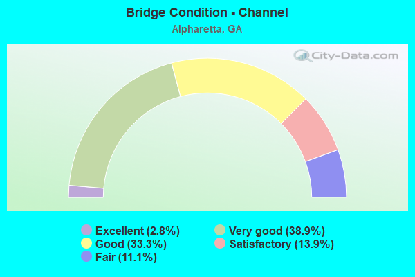
- Bridge Condition - Channel
- 2.8%Excellent
- 38.9%Very good
- 33.3%Good
- 13.9%Satisfactory
- 11.1%Fair
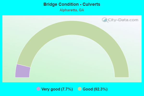
- Bridge Condition - Culverts
- 7.7%Very good
- 92.3%Good
Find on map >> Show street view
Structure Number: 1215292, Location: 2 MI SW OF ALPHARETTA (Lat: 34.070689, Lng: -84.325408), Route carried "on" structure: County highway 189, Year Built: 2001, Status: Open, Structure Length: 1.01m (3.31ft), Average Daily Traffic: 1,940 (year 2011), Truck Traffic: 1%, Average Future Daily Traffic: 2,910 (year 2031), Design Load: HS 20+Mod, Features Intersected: FOE KILLER CREEK TRIB, Facility Carried by Structure: HARRIS ROAD
Minimum Vertical Clearance: 30+ m (98+ ft), Kilometerpoint: 0.000, Lanes on structure: 3, Base Highway Network: Yes, Owner: City or Municipal Highway Agency, Approaching Roadway Width: 8.2m (26.9ft), Skew: 1 degrees, Material/Design: Concrete, Design/Construction: Culvert, Number Of Spans In Main Unit: 3, Length of Maximum Span: 3.0m (9.8ft), Curb or Sidewalk Widths: Left: 1.5m (4.9ft), Right: 1.5m (4.9ft)
Condition: Channel: Very good, Culverts: Good, Operating Rating: 55.3 metric tons, Method Used To Determine Operating Rating: Field evaluation and documented engineering judgment, Inventory Rating: 32.6 metric tons, Method Used To Determine Inventory Rating: Field evaluation and documented engineering judgment, Structural Evaluation: Better than present minimum criteria, Waterway Adequacy: Equal to present desirable criteria, Approach Roadway Alignment: Equal to present desirable criteria, Designated Inspection Frequency: Every 24 months, Inspection Date: August 2021, Bridge Improvement Cost: $164,000, Roadway Improvement Cost: $16,000, Total Project Cost: $246,000
Find on map >> Show street view
Structure Number: 1215295, Location: N ORTH ALPHARETTA CITY LI (Lat: 34.088267, Lng: -84.261772), Route carried "on" structure: US 19, Year Built: 2002, Status: Open, Structure Length: 10.42m (34.19ft), Average Daily Traffic: 88,400 (year 2011), Truck Traffic: 1%, Average Future Daily Traffic: 132,600 (year 2031), Design Load: HS 20+Mod, Features Intersected: M-9412 WINDWARD PKWY.
Minimum Vertical Clearance: 30+ m (98+ ft), Kilometerpoint: 33.796, Lanes on structure: 7, Lanes under structure: 8, Base Highway Network: Yes, Owner: State Highway Agency, Approaching Roadway Width: 40.2m (131.9ft), Skew: 34 degrees, Material/Design: Prestressed concrete, Design/Construction: Stringer/Multi-beam, Number Of Spans In Main Unit: 4, Length of Maximum Span: 39.9m (130.9ft), Curb-To-Curb Width: 40.7m (133.5ft), Out-to-Out Width: 42.4m (139.1ft)
Condition: Deck: Good, Superstructure: Very good, Substructure: Good, Operating Rating: 37.1 metric tons, Method Used To Determine Operating Rating: Load Factor (LF), Inventory Rating: 21.7 metric tons, Method Used To Determine Inventory Rating: Load Factor (LF), Structural Evaluation: Somewhat better than minimum adequacy, Deck Geometry: Superior to present desirable criteria, Underclear: Equal to present minimum criteria, Approach Roadway Alignment: Equal to present desirable criteria, Designated Inspection Frequency: Every 24 months, Inspection Date: October 2021, Bridge Improvement Cost: $3,158,000, Roadway Improvement Cost: $316,000, Total Project Cost: $4,738,000, Deck Structure Type: Concrete Cast-file-Place
Find on map >> Show street view
Structure Number: 1215341, Location: IN CITY LIMITS OF ALPHARE (Lat: 34.077478, Lng: -84.206389), Route carried "on" structure: City street 64, Year Built: 2011, Status: Open, Structure Length: 1.46m (4.79ft), Average Daily Traffic: 9,930 (year 2012), Truck Traffic: 1%, Average Future Daily Traffic: 14,895 (year 2032), Design Load: HS 20+Mod, Features Intersected: CANEY CREEK, Facility Carried by Structure: DOUGLAS ROAD
Minimum Vertical Clearance: 30+ m (98+ ft), Kilometerpoint: 1.609, Lanes on structure: 2, Base Highway Network: Yes, Owner: City or Municipal Highway Agency, Approaching Roadway Width: 6.7m (22.0ft), Material/Design: Prestressed concrete, Design/Construction: Box Beam or Girders - Multiple, Number Of Spans In Main Unit: 1, Length of Maximum Span: 14.6m (47.9ft), Curb or Sidewalk Widths: Left: 2.2m (7.2ft), Right: 2.2m (7.2ft), Curb-To-Curb Width: 9.6m (31.5ft), Out-to-Out Width: 14.8m (48.6ft)
Condition: Deck: Good, Superstructure: Good, Substructure: Very good, Channel: Very good, Operating Rating: 67.1 metric tons, Method Used To Determine Operating Rating: Load Factor (LF), Inventory Rating: 39.9 metric tons, Method Used To Determine Inventory Rating: Load Factor (LF), Structural Evaluation: Better than present minimum criteria, Deck Geometry: High priority of corrective action, Waterway Adequacy: Better than present minimum criteria, Approach Roadway Alignment: Equal to present minimum criteria, Designated Inspection Frequency: Every 24 months, Inspection Date: September 2021, Bridge Improvement Cost: $188,000, Roadway Improvement Cost: $19,000, Total Project Cost: $281,000, Deck Structure Type: Concrete Precast Panels, Wearing Surface/Protective System: Wearing Surface: Bituminous
Find on map >> Show street view
Structure Number: 1215352, Location: 2 MI SE OF ALPHARETTA (Lat: 34.050708, Lng: -84.269278), Route carried "on" structure: County highway 85, Year Built: 2011, Status: Open, Structure Length: 6.40m (21.00ft), Average Daily Traffic: 6,800 (year 2007), Truck Traffic: 1%, Average Future Daily Traffic: 10,200 (year 2030), Design Load: HS 20+Mod, Features Intersected: BIG CREEK, Facility Carried by Structure: KIMBALL BRIDGE RD
Minimum Vertical Clearance: 30+ m (98+ ft), Kilometerpoint: 3.219, Lanes on structure: 2, Base Highway Network: Yes, Owner: City or Municipal Highway Agency, Approaching Roadway Width: 9.8m (32.2ft), Material/Design: Prestressed concrete, Design/Construction: Stringer/Multi-beam, Number Of Spans In Main Unit: 3, Length of Maximum Span: 29.0m (95.1ft), Curb or Sidewalk Widths: Left: 1.8m (5.9ft), Right: 1.8m (5.9ft), Curb-To-Curb Width: 11.0m (36.1ft), Out-to-Out Width: 15.8m (51.8ft)
Condition: Deck: Good, Superstructure: Very good, Substructure: Good, Channel: Excellent, Operating Rating: 58.9 metric tons, Method Used To Determine Operating Rating: Load Factor (LF), Inventory Rating: 32.6 metric tons, Method Used To Determine Inventory Rating: Load Factor (LF), Structural Evaluation: Better than present minimum criteria, Deck Geometry: Meets minimum limits, Waterway Adequacy: Equal to present desirable criteria, Approach Roadway Alignment: Equal to present desirable criteria, Designated Inspection Frequency: Every 24 months, Inspection Date: September 2021, Bridge Improvement Cost: $821,000, Roadway Improvement Cost: $82,000, Total Project Cost: $1,231,000, Deck Structure Type: Concrete Cast-file-Place
Find on map >> Show street view
Structure Number: 1215364, Location: IN ALPHARETTA (Lat: 34.047447, Lng: -84.303700), Route carried "on" structure: City street 9407, Year Built: 2015, Status: Open, Structure Length: 9.20m (30.18ft), Average Daily Traffic: 21,870 (year 2017), Truck Traffic: 4%, Average Future Daily Traffic: 23,020 (year 2037), Design Load: HL 93, Features Intersected: SR 400 (US 19), Facility Carried by Structure: ENCORE PARKWAY
Minimum Vertical Clearance: 8.15m (26.74ft), Kilometerpoint: 3.219, Lanes on structure: 4, Lanes under structure: 8, Owner: State Highway Agency, Approaching Roadway Width: 9.1m (29.9ft), Skew: 30 degrees, Material/Design: Prestressed concrete, Design/Construction: Stringer/Multi-beam, Number Of Spans In Main Unit: 2, Length of Maximum Span: 46.0m (150.9ft), Curb or Sidewalk Widths: Left: 1.2m (3.9ft), Right: 1.2m (3.9ft), Curb-To-Curb Width: 16.5m (54.1ft), Out-to-Out Width: 35.3m (115.8ft)
Condition: Deck: Good, Superstructure: Very good, Substructure: Good, Operating Rating: 94.3 metric tons, Method Used To Determine Operating Rating: Load Factor (LF), Inventory Rating: 39.0 metric tons, Method Used To Determine Inventory Rating: Load Factor (LF), Structural Evaluation: Better than present minimum criteria, Deck Geometry: Meets minimum limits, Underclear: Superior to present desirable criteria, Approach Roadway Alignment: Equal to present minimum criteria, Length Of Structure Improvement: 11.03m (36.19ft), Designated Inspection Frequency: Every 24 months, Inspection Date: August 2021, Bridge Improvement Cost: $26,788,000, Roadway Improvement Cost: $2,679,000, Total Project Cost: $40,182,000 ( Estimate for 2016), Deck Structure Type: Concrete Cast-file-Place
Find on map >> Show street view
Structure Number: 1215391, Location: IN WEST ALPHARETTA (Lat: 34.078158, Lng: -84.344369), Route carried "on" structure: City street 9410, Year Built: 2019, Status: Open, Structure Length: 1.28m (4.20ft), Average Daily Traffic: 17,190 (year 2011), Truck Traffic: 1%, Average Future Daily Traffic: 25,785 (year 2031), Design Load: HL 93, Features Intersected: FOE KILLER CREEK TRIB, Facility Carried by Structure: RUCKER ROAD
Minimum Vertical Clearance: 30+ m (98+ ft), Kilometerpoint: 1.609, Lanes on structure: 2, Base Highway Network: Yes, Owner: City or Municipal Highway Agency, Approaching Roadway Width: 7.3m (24.0ft), Material/Design: Concrete, Design/Construction: Culvert, Number Of Spans In Main Unit: 1, Length of Maximum Span: 12.2m (40.0ft), Curb or Sidewalk Widths: Left: 2.4m (7.9ft), Right: 2.4m (7.9ft)
Condition: Channel: Very good, Culverts: Very good, Operating Rating: 72.5 metric tons, Method Used To Determine Operating Rating: Field evaluation and documented engineering judgment, Inventory Rating: 37.1 metric tons, Method Used To Determine Inventory Rating: Field evaluation and documented engineering judgment, Structural Evaluation: Equal to present desirable criteria, Waterway Adequacy: Equal to present desirable criteria, Approach Roadway Alignment: Equal to present desirable criteria, Length Of Structure Improvement: 1.52m (4.99ft), Designated Inspection Frequency: Every 24 months, Inspection Date: August 2021, Bridge Improvement Cost: $3,700,000, Roadway Improvement Cost: $370,000, Total Project Cost: $5,550,000 ( Estimate for 2019)
Find on map >> Show street view
Structure Number: 1170011, Location: 6 MI SW OF CUMMING (Lat: 34.129608, Lng: -84.210578), Route carried "under" structure: US 19, Structure Length: 0. m, Average Daily Traffic: 42,100 (year 2000), Truck Traffic: 1%, Features Intersected: CR 53 PINE GROVE ROAD, Facility Carried by Structure: SHILOH ROAD
Minimum Vertical Clearance: 5.46m (17.91ft), Kilometerpoint: 4.828, Lanes on structure: 2, Length of Maximum Span: 0.0m
Find on map >> Show street view
Structure Number: 1170042, Location: 8 MI SW OF CUMMING (Lat: 34.114628, Lng: -84.222942), Route carried "under" structure: US 19, Structure Length: 0. m, Average Daily Traffic: 42,100 (year 2000), Truck Traffic: 1%, Features Intersected: FAS 2883 MCFARLAND RD, Facility Carried by Structure: MCFARLAND ROAD
Minimum Vertical Clearance: 5.89m (19.32ft), Kilometerpoint: 1.609, Lanes on structure: 8, Length of Maximum Span: 0.0m
Find on map >> Show street view
Structure Number: 1170042, Location: 8 MI SW OF CUMMING (Lat: 34.114628, Lng: -84.222942), Route carried "under" structure: US 19, Structure Length: 0. m, Average Daily Traffic: 42,100 (year 2000), Features Intersected: FAS 2883 MCFARLAND RD, Facility Carried by Structure: MCFARLAND ROAD
Minimum Vertical Clearance: 4.97m (16.31ft), Kilometerpoint: 1.609, Lanes on structure: 8, Length of Maximum Span: 0.0m
Find on map >> Show street view
Structure Number: 1175059, Location: 0.65 MI N FULTON CO LN (Lat: 34.108019, Lng: -84.236800), Route carried "under" structure: US 19, Structure Length: 0. m, Average Daily Traffic: 49,000 (year 2000), Truck Traffic: 1%, Features Intersected: CR 456 UNION HILL ROAD, Facility Carried by Structure: UNION HILL ROAD
Minimum Vertical Clearance: 5.51m (18.08ft), Kilometerpoint: 1.609, Lanes on structure: 4, Length of Maximum Span: 0.0m
Find on map >> Show street view
Structure Number: 1210075, Location: IN NE ALPHARETTA (Lat: 34.068750, Lng: -84.271969), Route carried "under" structure: US 19, Structure Length: 0. m, Average Daily Traffic: 86,500 (year 2002), Truck Traffic: 1%, Features Intersected: SR 120 STATE BRIDGE ROAD, Facility Carried by Structure: OLD MILTON PARKWAY
Minimum Vertical Clearance: 5.28m (17.32ft), Kilometerpoint: 32.187, Lanes on structure: 8, Length of Maximum Span: 0.0m
Find on map >> Show street view
Structure Number: 1210285, Location: APP .5 MI W JCT FAS 2349 (Lat: 34.102647, Lng: -84.244444), Route carried "under" structure: US 19, Structure Length: 0. m, Average Daily Traffic: 66,700 (year 1999), Truck Traffic: 1%, Features Intersected: S-2564 MCGINNIS FERRY RD, Facility Carried by Structure: McGINNIS FERRY RD
Minimum Vertical Clearance: 5.63m (18.47ft), Kilometerpoint: 35.406, Lanes on structure: 2, Length of Maximum Span: 0.0m
Find on map >> Show street view
Structure Number: 1210299, Location: 0.85 MI N OF SR 120 (Lat: 34.074756, Lng: -84.268800), Route carried "under" structure: US 19, Structure Length: 0. m, Average Daily Traffic: 86,500 (year 1999), Truck Traffic: 1%, Features Intersected: M-9411 WEBB BRIDGE ROAD, Facility Carried by Structure: WEBB BRIDGE ROAD
Minimum Vertical Clearance: 5.23m (17.16ft), Kilometerpoint: 32.187, Lanes on structure: 2, Length of Maximum Span: 0.0m
Find on map >> Show street view
Structure Number: 1210303, Location: 11.3 MI N OF I-285 (Lat: 34.054439, Lng: -84.285658), Route carried "under" structure: US 19, Structure Length: 0. m, Average Daily Traffic: 95,700 (year 2002), Truck Traffic: 1%, Features Intersected: M-9409 HAYNES BRIDGE RD., Facility Carried by Structure: HAYNES BRIDGE RD
Minimum Vertical Clearance: 6.57m (21.56ft), Kilometerpoint: 28.968, Lanes on structure: 8, Length of Maximum Span: 0.0m
Find on map >> Show street view
Structure Number: 1210475, Location: IN EAST ALPHARETTA (Lat: 34.060450, Lng: -84.276269), Route carried "under" structure: US 19, Structure Length: 0. m, Average Daily Traffic: 95,700 (year 2002), Truck Traffic: 1%, Features Intersected: CR 85 KIMBALL BRIDGE RD., Facility Carried by Structure: KIMBALL BRIDGE RD.
Minimum Vertical Clearance: 6.83m (22.41ft), Kilometerpoint: 30.578, Lanes on structure: 2, Length of Maximum Span: 0.0m
Find on map >> Show street view
Structure Number: 1210732, Location: IN SOUTH ALPHARETTA (Lat: 34.039192, Lng: -84.311331), Route carried "under" structure: County highway 9486, Structure Length: 0. m, Average Daily Traffic: 49,800 (year 1999), Truck Traffic: 1%, Features Intersected: SR 400 (US 19), Facility Carried by Structure: US 19
Minimum Vertical Clearance: 5.56m (18.24ft), Kilometerpoint: 3.219, Lanes on structure: 8, Length of Maximum Span: 0.0m
Find on map >> Show street view
Structure Number: 1215295, Location: N ORTH ALPHARETTA CITY LI (Lat: 34.088267, Lng: -84.261772), Route carried "under" structure: City street 9412, Structure Length: 0. m, Average Daily Traffic: 14,300 (year 2003), Truck Traffic: 4%, Features Intersected: SR 400 (US 19), Facility Carried by Structure: US 19
Minimum Vertical Clearance: 6.60m (21.65ft), Kilometerpoint: 3.219, Lanes on structure: 7, Length of Maximum Span: 0.0m
Find on map >> Show street view
Structure Number: 1215364, Location: IN ALPHARETTA (Lat: 34.047447, Lng: -84.303700), Route carried "under" structure: US 19, Structure Length: 0. m, Average Daily Traffic: 113,100 (year 1999), Truck Traffic: 4%, Features Intersected: ENCORE PARKWAY, Facility Carried by Structure: ENCORE PARKWAY
Minimum Vertical Clearance: 7.46m (24.48ft), Kilometerpoint: 27.359, Lanes on structure: 4, Length of Maximum Span: 0.0m