Bridge Statistics for Altoona, Pennsylvania (PA)
Condition, Traffic, Stress, Structural Evaluation, Project Costs

- New bridges - historical statistics
- 11900-1909
- 11910-1919
- 11920-1929
- 41930-1939
- 41940-1949
- 41950-1959
- 51960-1969
- 121970-1979
- 121980-1989
- 171990-1999
- 62000-2009
- 82010-2019
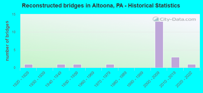
- Reconstructed bridges - Historical Statistics
- 11920-1929
- 01930-1939
- 11940-1949
- 11950-1959
- 01960-1969
- 11970-1979
- 01980-1989
- 01990-1999
- 132000-2009
- 32010-2019
- 12020-2022
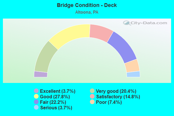
- Bridge Condition - Deck
- 3.7%Excellent
- 20.4%Very good
- 27.8%Good
- 14.8%Satisfactory
- 22.2%Fair
- 7.4%Poor
- 3.7%Serious
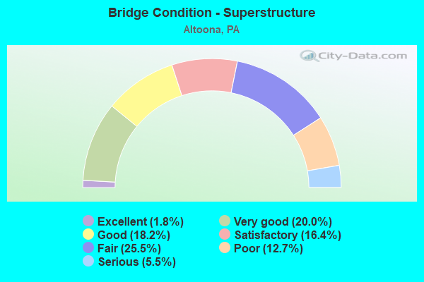
- Bridge Condition - Superstructure
- 1.8%Excellent
- 20.0%Very good
- 18.2%Good
- 16.4%Satisfactory
- 25.5%Fair
- 12.7%Poor
- 5.5%Serious
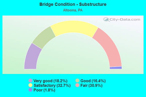
- Bridge Condition - Substructure
- 18.2%Very good
- 16.4%Good
- 32.7%Satisfactory
- 30.9%Fair
- 1.8%Poor
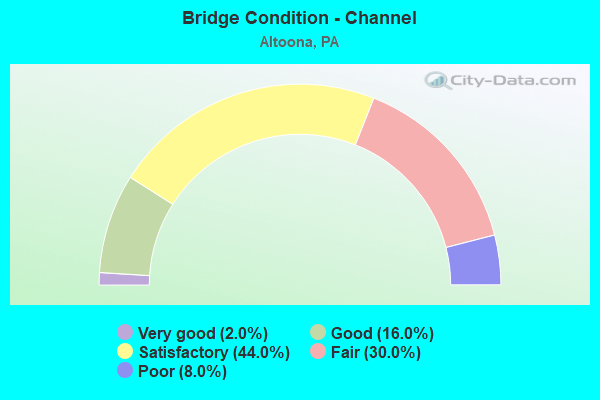
- Bridge Condition - Channel
- 2.0%Very good
- 16.0%Good
- 44.0%Satisfactory
- 30.0%Fair
- 8.0%Poor
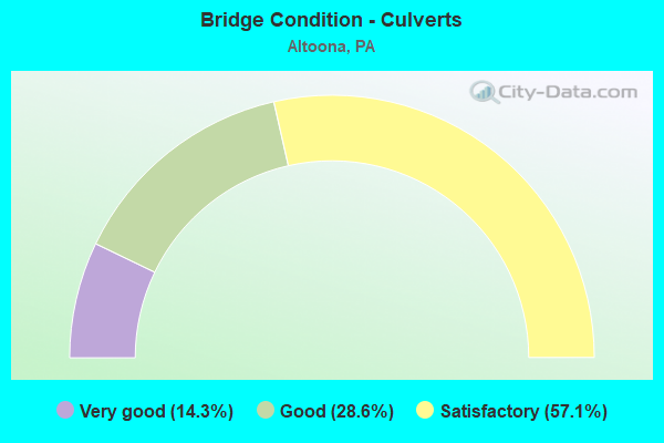
- Bridge Condition - Culverts
- 14.3%Very good
- 28.6%Good
- 57.1%Satisfactory
Find on map >> Show street view
Structure Number: 5983, Location: 29TH ST.@ BEALE AVENUE (Lat: 40.498697, Lng: -78.412700), Route carried "on" structure: City street , Year Built: 1990, Status: Open, Structure Length: 1.04m (3.41ft), Average Daily Traffic: 4,698 (year 2021), Truck Traffic: 4%, Average Future Daily Traffic: 6,328 (year 2041), Design Load: HS 25 or greater, Features Intersected: NORFOLK SOUTHERN, Facility Carried by Structure: 29TH STREET
Minimum Vertical Clearance: 30+ m (98+ ft), Kilometerpoint: 0.000, Lanes on structure: 2, Owner: City or Municipal Highway Agency, Approaching Roadway Width: 7.3m (24.0ft), Material/Design: Prestressed concrete, Design/Construction: Box Beam or Girders - Multiple, Number Of Spans In Main Unit: 1, Length of Maximum Span: 9.8m (32.2ft), Curb or Sidewalk Widths: Left: 1.9m (6.2ft), Right: 1.9m (6.2ft), Curb-To-Curb Width: 7.3m (24.0ft), Out-to-Out Width: 12.4m (40.7ft)
Condition: Deck: Satisfactory, Superstructure: Good, Substructure: Fair, Inventory Rating: 56.2 metric tons, Method Used To Determine Inventory Rating: Load Factor (LF), Structural Evaluation: Somewhat better than minimum adequacy, Deck Geometry: High priority of replacement, Underclear: High priority of corrective action, Approach Roadway Alignment: Better than present minimum criteria, Length Of Structure Improvement: 1.70m (5.58ft), Designated Inspection Frequency: Every 24 months, Inspection Date: October 2021, Bridge Improvement Cost: $11,000, Roadway Improvement Cost: $32,000, Total Project Cost: $147,000, Deck Structure Type: Concrete Cast-file-Place, Wearing Surface/Protective System: Wearing Surface: Monolithic Concrete, Deck Protection: Epoxy Coated Reinforcing
Find on map >> Show street view
Structure Number: 5984, Location: 31ST.STREET, ALTOONA (Lat: 40.496100, Lng: -78.413019), Route carried "on" structure: City street , Year Built: 1995, Status: Open, Structure Length: 1.13m (3.71ft), Average Daily Traffic: 5,432 (year 2021), Truck Traffic: 4%, Average Future Daily Traffic: 7,316 (year 2041), Design Load: HS 25 or greater, Features Intersected: MILL RUN CREEK, Facility Carried by Structure: 31ST STREET
Minimum Vertical Clearance: 30+ m (98+ ft), Kilometerpoint: 0.000, Lanes on structure: 2, Owner: City or Municipal Highway Agency, Approaching Roadway Width: 8.5m (27.9ft), Skew: 4 degrees, Material/Design: Concrete, Design/Construction: Culvert, Number Of Spans In Main Unit: 2, Length of Maximum Span: 3.7m (12.1ft), Curb-To-Curb Width: 9.4m (30.8ft), Out-to-Out Width: 36.9m (121.1ft)
Condition: Channel: Satisfactory, Culverts: Satisfactory, Operating Rating: 78.0 metric tons, Method Used To Determine Operating Rating: Load Factor (LF), Inventory Rating: 47.2 metric tons, Method Used To Determine Inventory Rating: Load Factor (LF), Structural Evaluation: Equal to present minimum criteria, Deck Geometry: High priority of corrective action, Waterway Adequacy: Equal to present minimum criteria, Approach Roadway Alignment: Equal to present desirable criteria, Length Of Structure Improvement: 1.70m (5.58ft), Designated Inspection Frequency: Every 24 months, Inspection Date: July 2021
Find on map >> Show street view
Structure Number: 5985, Location: 37 TH ST,ALTOONA (Lat: 40.489736, Lng: -78.417408), Route carried "on" structure: City street , Year Built: 1985, Status: Open, Structure Length: 6.22m (20.41ft), Average Daily Traffic: 4,878 (year 2019), Truck Traffic: 3%, Average Future Daily Traffic: 6,570 (year 2039), Design Load: HS 20+Mod, Features Intersected: NORFOLK SOUTHERN RR, Facility Carried by Structure: 37TH STREET
Minimum Vertical Clearance: 30+ m (98+ ft), Kilometerpoint: 0.000, Lanes on structure: 2, Owner: City or Municipal Highway Agency, Approaching Roadway Width: 9.8m (32.2ft), Material/Design: Prestressed concrete, Design/Construction: Box Beam or Girders - Multiple, Number Of Spans In Main Unit: 1, Number Of Approach Spans: 3, Length of Maximum Span: 22.9m (75.1ft), Curb or Sidewalk Widths: Left: 0.2m (0.7ft), Right: 1.5m (4.9ft), Curb-To-Curb Width: 9.4m (30.8ft), Out-to-Out Width: 12.1m (39.7ft)
Condition: Deck: Satisfactory, Superstructure: Fair, Substructure: Fair, Operating Rating: 59.0 metric tons, Method Used To Determine Operating Rating: Load Factor (LF), Inventory Rating: 19.1 metric tons, Method Used To Determine Inventory Rating: Load Factor (LF), Structural Evaluation: Somewhat better than minimum adequacy, Deck Geometry: Meets minimum limits, Underclear: High priority of corrective action, Approach Roadway Alignment: Better than present minimum criteria, Length Of Structure Improvement: 7.70m (25.26ft), Designated Inspection Frequency: Every 24 months, Inspection Date: June 2021, Deck Structure Type: Concrete Cast-file-Place, Wearing Surface/Protective System: Wearing Surface: Monolithic Concrete, Deck Protection: Epoxy Coated Reinforcing
Find on map >> Show street view
Structure Number: 5986, Location: 58TH.ST. & KISSEL AVE. (Lat: 40.475767, Lng: -78.428644), Route carried "on" structure: City street , Year Built: 1994, Status: Open, Structure Length: 1.68m (5.51ft), Average Daily Traffic: 5,566 (year 2020), Truck Traffic: 5%, Average Future Daily Traffic: 7,497 (year 2040), Design Load: HS 25 or greater, Features Intersected: BURGOON RUN, Facility Carried by Structure: 58TH STREET
Minimum Vertical Clearance: 30+ m (98+ ft), Kilometerpoint: 0.000, Lanes on structure: 2, Owner: City or Municipal Highway Agency, Approaching Roadway Width: 11.0m (36.1ft), Skew: 3 degrees, Material/Design: Concrete, Design/Construction: Culvert, Number Of Spans In Main Unit: 2, Length of Maximum Span: 6.7m (22.0ft), Curb-To-Curb Width: 11.0m (36.1ft), Out-to-Out Width: 12.1m (39.7ft)
Condition: Channel: Fair, Culverts: Satisfactory, Operating Rating: 67.1 metric tons, Method Used To Determine Operating Rating: Load Factor (LF), Inventory Rating: 39.9 metric tons, Method Used To Determine Inventory Rating: Load Factor (LF), Structural Evaluation: Equal to present minimum criteria, Deck Geometry: Meets minimum limits, Waterway Adequacy: Better than present minimum criteria, Approach Roadway Alignment: Equal to present desirable criteria, Length Of Structure Improvement: 2.40m (7.87ft), Designated Inspection Frequency: Every 24 months, Inspection Date: June 2020
Find on map >> Show street view
Structure Number: 5987, Location: BROAD AVE OVER BURGOON RU (Lat: 40.477550, Lng: -78.429567), Route carried "on" structure: City street , Year Built: 1940, Status: Open, Structure Length: 1.49m (4.89ft), Average Daily Traffic: 1,424 (year 2021), Truck Traffic: 1%, Average Future Daily Traffic: 1,918 (year 2041), Features Intersected: BURGOON RUN, Facility Carried by Structure: BROAD AVENUE
Minimum Vertical Clearance: 30+ m (98+ ft), Kilometerpoint: 0.000, Lanes on structure: 2, Owner: City or Municipal Highway Agency, Approaching Roadway Width: 5.2m (17.1ft), Material/Design: Concrete, Design/Construction: Tee Beam, Number Of Spans In Main Unit: 1, Length of Maximum Span: 13.7m (44.9ft), Curb or Sidewalk Widths: Left: 0.0m, Right: 1.7m (5.6ft), Curb-To-Curb Width: 7.8m (25.6ft), Out-to-Out Width: 10.1m (33.1ft)
Condition: Deck: Fair, Superstructure: Poor, Substructure: Satisfactory, Channel: Fair, Operating Rating: 49.0 metric tons, Method Used To Determine Operating Rating: Field evaluation and documented engineering judgment, Inventory Rating: 29.0 metric tons, Method Used To Determine Inventory Rating: Field evaluation and documented engineering judgment, Structural Evaluation: Meets minimum limits, Deck Geometry: Meets minimum limits, Waterway Adequacy: Better than present minimum criteria, Approach Roadway Alignment: Somewhat better than minimum adequacy, Length Of Structure Improvement: 1.90m (6.23ft), Designated Inspection Frequency: Every 24 months, Inspection Date: September 2021, Bridge Improvement Cost: $58,000, Roadway Improvement Cost: $264,000, Total Project Cost: $784,000, Deck Structure Type: Concrete Cast-file-Place, Wearing Surface/Protective System: Wearing Surface: Bituminous
Find on map >> Show street view
Structure Number: 5988, Location: COLERIDGE AVE.,ALTOONA (Lat: 40.479669, Lng: -78.405750), Route carried "on" structure: City street , Year Built: 1963, Year Reconstructed: 2019, Status: Open, Structure Length: 2.13m (6.99ft), Average Daily Traffic: 2,200 (year 2019), Truck Traffic: 2%, Average Future Daily Traffic: 2,963 (year 2039), Design Load: HS 20, Features Intersected: MILL RUN CREEK, Facility Carried by Structure: COLERIDGE AVENUE
Minimum Vertical Clearance: 30+ m (98+ ft), Kilometerpoint: 0.000, Lanes on structure: 2, Owner: City or Municipal Highway Agency, Approaching Roadway Width: 9.1m (29.9ft), Skew: 1 degrees, Material/Design: Prestressed concrete, Design/Construction: Box Beam or Girders - Multiple, Number Of Spans In Main Unit: 2, Length of Maximum Span: 10.1m (33.1ft), Curb or Sidewalk Widths: Left: 1.5m (4.9ft), Right: 1.5m (4.9ft), Curb-To-Curb Width: 9.1m (29.9ft), Out-to-Out Width: 13.0m (42.7ft)
Condition: Deck: Excellent, Superstructure: Fair, Substructure: Satisfactory, Channel: Good, Operating Rating: 78.0 metric tons, Method Used To Determine Operating Rating: Load Factor (LF), Inventory Rating: 13.6 metric tons, Method Used To Determine Inventory Rating: Load Factor (LF), Structural Evaluation: Meets minimum limits, Deck Geometry: Meets minimum limits, Waterway Adequacy: Equal to present desirable criteria, Approach Roadway Alignment: Equal to present desirable criteria, Length Of Structure Improvement: 2.70m (8.86ft), Designated Inspection Frequency: Every 24 months, Inspection Date: November 2019, Bridge Improvement Cost: $72,000, Roadway Improvement Cost: $264,000, Total Project Cost: $969,000, Deck Structure Type: Concrete Precast Panels, Wearing Surface/Protective System: Wearing Surface: Monolithic Concrete, Deck Protection: Epoxy Coated Reinforcing
Find on map >> Show street view
Structure Number: 5989, Location: OAK AVE.@ 58TH ST,ALTOONA (Lat: 40.479383, Lng: -78.431131), Route carried "on" structure: City street , Year Built: 1993, Status: Open, Structure Length: 1.58m (5.18ft), Average Daily Traffic: 3,153 (year 2019), Truck Traffic: 3%, Average Future Daily Traffic: 4,247 (year 2039), Design Load: HS 25 or greater, Features Intersected: BURGOON RUN, Facility Carried by Structure: OAK AVENUE
Minimum Vertical Clearance: 30+ m (98+ ft), Kilometerpoint: 0.000, Lanes on structure: 2, Owner: City or Municipal Highway Agency, Approaching Roadway Width: 10.4m (34.1ft), Skew: 2 degrees, Material/Design: Prestressed concrete, Design/Construction: Box Beam or Girders - Multiple, Number Of Spans In Main Unit: 1, Length of Maximum Span: 15.2m (49.9ft), Curb or Sidewalk Widths: Left: 0.2m (0.7ft), Right: 0.2m (0.7ft), Curb-To-Curb Width: 11.3m (37.1ft), Out-to-Out Width: 12.3m (40.4ft)
Condition: Deck: Fair, Superstructure: Satisfactory, Substructure: Satisfactory, Channel: Satisfactory, Operating Rating: 90.7 metric tons, Method Used To Determine Operating Rating: Load Factor (LF), Inventory Rating: 44.5 metric tons, Method Used To Determine Inventory Rating: Load Factor (LF), Structural Evaluation: Equal to present minimum criteria, Deck Geometry: Somewhat better than minimum adequacy, Waterway Adequacy: Better than present minimum criteria, Approach Roadway Alignment: Better than present minimum criteria, Length Of Structure Improvement: 2.30m (7.55ft), Designated Inspection Frequency: Every 24 months, Inspection Date: September 2021, Deck Structure Type: Concrete Cast-file-Place, Wearing Surface/Protective System: Wearing Surface: Monolithic Concrete, Deck Protection: Epoxy Coated Reinforcing
Find on map >> Show street view
Structure Number: 5991, Location: PINE AVE AT 31ST STREET (Lat: 40.500553, Lng: -78.422483), Route carried "on" structure: City street , Year Built: 1993, Status: Open, Structure Length: 0.94m (3.08ft), Average Daily Traffic: 1,546 (year 2021), Truck Traffic: 5%, Average Future Daily Traffic: 2,082 (year 2041), Design Load: HS 25 or greater, Features Intersected: MILL RUN, Facility Carried by Structure: PINE AVENUE
Minimum Vertical Clearance: 30+ m (98+ ft), Kilometerpoint: 0.000, Lanes on structure: 2, Owner: City or Municipal Highway Agency, Approaching Roadway Width: 9.4m (30.8ft), Skew: 2 degrees, Material/Design: Prestressed concrete, Design/Construction: Box Beam or Girders - Multiple, Number Of Spans In Main Unit: 1, Length of Maximum Span: 7.6m (24.9ft), Curb or Sidewalk Widths: Left: 2.6m (8.5ft), Right: 2.6m (8.5ft), Curb-To-Curb Width: 9.1m (29.9ft), Out-to-Out Width: 14.9m (48.9ft)
Condition: Deck: Fair, Superstructure: Fair, Substructure: Fair, Channel: Satisfactory, Operating Rating: 88.9 metric tons, Method Used To Determine Operating Rating: Load Factor (LF), Inventory Rating: 29.9 metric tons, Method Used To Determine Inventory Rating: Load Factor (LF), Structural Evaluation: Somewhat better than minimum adequacy, Deck Geometry: Somewhat better than minimum adequacy, Waterway Adequacy: Better than present minimum criteria, Approach Roadway Alignment: Equal to present desirable criteria, Length Of Structure Improvement: 1.60m (5.25ft), Designated Inspection Frequency: Every 24 months, Inspection Date: June 2021, Deck Structure Type: Other, Wearing Surface/Protective System: Wearing Surface: Bituminous, Membrane: Preformed Fabric
Find on map >> Show street view
Structure Number: 5993, Location: W.CHESTNUT AVE.& 31ST.STR (Lat: 40.497814, Lng: -78.417728), Route carried "on" structure: City street , Year Built: 1930, Status: Open, Structure Length: 0.88m (2.89ft), Average Daily Traffic: 1,848 (year 2021), Truck Traffic: 2%, Average Future Daily Traffic: 2,489 (year 2041), Features Intersected: MILL RUN, Facility Carried by Structure: WEST CHESTNUT AVE.
Minimum Vertical Clearance: 30+ m (98+ ft), Kilometerpoint: 0.000, Lanes on structure: 2, Owner: City or Municipal Highway Agency, Approaching Roadway Width: 9.1m (29.9ft), Material/Design: Concrete continuous, Design/Construction: Slab, Number Of Spans In Main Unit: 2, Length of Maximum Span: 4.3m (14.1ft), Curb or Sidewalk Widths: Left: 1.3m (4.3ft), Right: 1.7m (5.6ft), Curb-To-Curb Width: 11.2m (36.7ft), Out-to-Out Width: 15.3m (50.2ft)
Condition: Deck: Poor, Superstructure: Poor, Substructure: Fair, Channel: Satisfactory, Operating Rating: 42.6 metric tons, Method Used To Determine Operating Rating: Field evaluation and documented engineering judgment, Inventory Rating: 25.4 metric tons, Method Used To Determine Inventory Rating: Field evaluation and documented engineering judgment, Structural Evaluation: Meets minimum limits, Deck Geometry: Equal to present minimum criteria, Waterway Adequacy: Better than present minimum criteria, Approach Roadway Alignment: Equal to present desirable criteria, Length Of Structure Improvement: 1.10m (3.61ft), Designated Inspection Frequency: Every 24 months, Other Special Inspection Frequency: Every 12 months, Inspection Date: October 2021, Other Special Inspection Date: October 2021, Bridge Improvement Cost: $44,000, Roadway Improvement Cost: $222,000, Total Project Cost: $589,000, Deck Structure Type: Concrete Cast-file-Place, Wearing Surface/Protective System: Wearing Surface: Bituminous, Membrane: Preformed Fabric
Find on map >> Show street view
Structure Number: 5994, Location: WALNUT AVE.@ 31ST.STREET (Lat: 40.499678, Lng: -78.420408), Route carried "on" structure: City street , Year Built: 1993, Status: Open, Structure Length: 0.88m (2.89ft), Average Daily Traffic: 1,280 (year 2021), Truck Traffic: 3%, Average Future Daily Traffic: 1,724 (year 2041), Design Load: HS 25 or greater, Features Intersected: MILL RUN, Facility Carried by Structure: WALNUT AVENUE
Minimum Vertical Clearance: 30+ m (98+ ft), Kilometerpoint: 0.000, Lanes on structure: 2, Owner: City or Municipal Highway Agency, Approaching Roadway Width: 9.1m (29.9ft), Skew: 1 degrees, Material/Design: Prestressed concrete, Design/Construction: Box Beam or Girders - Multiple, Number Of Spans In Main Unit: 1, Length of Maximum Span: 7.3m (24.0ft), Curb or Sidewalk Widths: Left: 2.6m (8.5ft), Right: 2.6m (8.5ft), Curb-To-Curb Width: 9.1m (29.9ft), Out-to-Out Width: 14.9m (48.9ft)
Condition: Deck: Fair, Superstructure: Fair, Substructure: Fair, Channel: Satisfactory, Operating Rating: 77.1 metric tons, Method Used To Determine Operating Rating: Load Factor (LF), Inventory Rating: 31.8 metric tons, Method Used To Determine Inventory Rating: Load Factor (LF), Structural Evaluation: Somewhat better than minimum adequacy, Deck Geometry: Somewhat better than minimum adequacy, Waterway Adequacy: Better than present minimum criteria, Approach Roadway Alignment: Equal to present desirable criteria, Length Of Structure Improvement: 1.50m (4.92ft), Designated Inspection Frequency: Every 24 months, Inspection Date: May 2021, Deck Structure Type: Other, Wearing Surface/Protective System: Wearing Surface: Bituminous
Find on map >> Show street view
Structure Number: 5995, Location: W SPRUCE AVE @ 31ST STR. (Lat: 40.500267, Lng: -78.421339), Route carried "on" structure: City street , Year Built: 1980, Year Reconstructed: 2016, Status: Open, Structure Length: 0.91m (2.99ft), Average Daily Traffic: 1,006 (year 2020), Truck Traffic: 3%, Average Future Daily Traffic: 1,355 (year 2040), Design Load: HS 20, Features Intersected: MILL RUN, Facility Carried by Structure: W SPRUCE AVENUE
Minimum Vertical Clearance: 30+ m (98+ ft), Kilometerpoint: 0.000, Lanes on structure: 2, Owner: City or Municipal Highway Agency, Approaching Roadway Width: 9.1m (29.9ft), Skew: 2 degrees, Material/Design: Prestressed concrete, Design/Construction: Box Beam or Girders - Multiple, Number Of Spans In Main Unit: 1, Length of Maximum Span: 9.1m (29.9ft), Curb or Sidewalk Widths: Left: 2.7m (8.9ft), Right: 2.7m (8.9ft), Curb-To-Curb Width: 9.1m (29.9ft), Out-to-Out Width: 15.2m (49.9ft)
Condition: Deck: Very good, Superstructure: Fair, Substructure: Fair, Channel: Fair, Inventory Rating: 55.3 metric tons, Method Used To Determine Inventory Rating: Load Factor (LF), Structural Evaluation: Somewhat better than minimum adequacy, Deck Geometry: Somewhat better than minimum adequacy, Waterway Adequacy: Better than present minimum criteria, Approach Roadway Alignment: Better than present minimum criteria, Length Of Structure Improvement: 1.20m (3.94ft), Designated Inspection Frequency: Every 24 months, Inspection Date: August 2020, Bridge Improvement Cost: $48,000, Roadway Improvement Cost: $251,000, Total Project Cost: $645,000, Deck Structure Type: Concrete Cast-file-Place, Wearing Surface/Protective System: Wearing Surface: Epoxy Overlay, Membrane: Epoxy, Deck Protection: Epoxy Coated Reinforcing
Find on map >> Show street view
Structure Number: 42004, Location: ALTOONA, JUNIATA (Lat: 40.532436, Lng: -78.386403), Route carried "on" structure: State highway , Year Built: 2003, Status: Open, Structure Length: 1.01m (3.31ft), Average Daily Traffic: 8,986 (year 2021), Truck Traffic: 4%, Average Future Daily Traffic: 12,766 (year 2032), Design Load: HS 25 or greater, Features Intersected: SPRING RUN, Facility Carried by Structure: SR 4013
Minimum Vertical Clearance: 30+ m (98+ ft), Kilometerpoint: 1.814, Lanes on structure: 5, Owner: State Highway Agency, Approaching Roadway Width: 21.9m (71.9ft), Skew: 20 degrees, Material/Design: Concrete, Design/Construction: Culvert, Number Of Spans In Main Unit: 2, Length of Maximum Span: 4.6m (15.1ft), Curb or Sidewalk Widths: Left: 0.0m, Right: 1.5m (4.9ft)
Condition: Channel: Fair, Culverts: Very good, Operating Rating: 89.8 metric tons, Method Used To Determine Operating Rating: Load Factor (LF), Inventory Rating: 89.8 metric tons, Method Used To Determine Inventory Rating: Load Factor (LF), Structural Evaluation: Equal to present desirable criteria, Waterway Adequacy: Equal to present desirable criteria, Approach Roadway Alignment: Equal to present desirable criteria, Length Of Structure Improvement: 1.60m (5.25ft), Designated Inspection Frequency: Every 48 months, Inspection Date: April 2019
Find on map >> Show street view
Structure Number: 42212, Location: 2 MI SW OF ALTOONA (Lat: 40.485750, Lng: -78.433208), Route carried "on" structure: City street , Year Built: 2003, Status: Open, Structure Length: 1.46m (4.79ft), Average Daily Traffic: 532 (year 2021), Truck Traffic: 1%, Average Future Daily Traffic: 682 (year 2041), Design Load: HS 25 or greater, Features Intersected: BURGOON RUN, Facility Carried by Structure: T406,58TH STREET
Minimum Vertical Clearance: 30+ m (98+ ft), Kilometerpoint: 0.000, Lanes on structure: 2, Owner: Town or Township Highway Agency, Approaching Roadway Width: 9.8m (32.2ft), Skew: 1 degrees, Material/Design: Prestressed concrete, Design/Construction: Box Beam or Girders - Single/Spread, Number Of Spans In Main Unit: 1, Length of Maximum Span: 14.0m (45.9ft), Curb or Sidewalk Widths: Left: 0.2m (0.7ft), Right: 0.2m (0.7ft), Curb-To-Curb Width: 9.8m (32.2ft), Out-to-Out Width: 10.6m (34.8ft)
Condition: Deck: Good, Superstructure: Good, Substructure: Good, Channel: Satisfactory, Operating Rating: 80.7 metric tons, Method Used To Determine Operating Rating: Load Factor (LF), Inventory Rating: 46.3 metric tons, Method Used To Determine Inventory Rating: Load Factor (LF), Structural Evaluation: Better than present minimum criteria, Deck Geometry: Equal to present minimum criteria, Waterway Adequacy: Better than present minimum criteria, Approach Roadway Alignment: Better than present minimum criteria, Length Of Structure Improvement: 2.10m (6.89ft), Designated Inspection Frequency: Every 24 months, Inspection Date: October 2021, Deck Structure Type: Concrete Cast-file-Place, Wearing Surface/Protective System: Wearing Surface: Monolithic Concrete, Deck Protection: Epoxy Coated Reinforcing
Find on map >> Show street view
Structure Number: 42872, Location: 7TH STREET BRIDGE (Lat: 40.518269, Lng: -78.394544), Route carried "on" structure: State highway , Year Built: 2005, Year Reconstructed: 2013, Status: Open, Structure Length: 16.49m (54.10ft), Average Daily Traffic: 12,169 (year 2022), Truck Traffic: 2%, Average Future Daily Traffic: 17,114 (year 2032), Design Load: HL 93, Features Intersected: NORFOLK SO. RR & 8TH AVE, Facility Carried by Structure: SR 4013 NBL
Minimum Vertical Clearance: 5.31m (17.42ft), Kilometerpoint: 0.000, Lanes on structure: 2, Lanes under structure: 2, Base Highway Network: Yes, Owner: State Highway Agency, Approaching Roadway Width: 11.6m (38.1ft), Skew: 10 degrees, Material/Design: Prestressed concrete, Design/Construction: Box Beam or Girders - Multiple, Number Of Spans In Main Unit: 5, Number Of Approach Spans: 1, Length of Maximum Span: 39.0m (128.0ft), Curb or Sidewalk Widths: Left: 0.2m (0.7ft), Right: 2.1m (6.9ft), Curb-To-Curb Width: 11.5m (37.7ft), Out-to-Out Width: 14.9m (48.9ft)
Condition: Deck: Good, Superstructure: Good, Substructure: Good, Operating Rating: 58.0 metric tons, Method Used To Determine Operating Rating: Assigned ratings based on Load and Resistance Factor Design (LRFD) reported by rating factor (RF) using HL93 loadings, Inventory Rating: 36.6 metric tons, Method Used To Determine Inventory Rating: Assigned ratings based on Load and Resistance Factor Design (LRFD) reported by rating factor (RF) using HL93 loadings, Structural Evaluation: Better than present minimum criteria, Deck Geometry: Equal to present minimum criteria, Underclear: Equal to present minimum criteria, Approach Roadway Alignment: Equal to present desirable criteria, Length Of Structure Improvement: 17.30m (56.76ft), Designated Inspection Frequency: Every 48 months, Inspection Date: November 2019, Deck Structure Type: Concrete Cast-file-Place, Wearing Surface/Protective System: Wearing Surface: Epoxy Overlay, Deck Protection: Epoxy Coated Reinforcing
Find on map >> Show street view
Structure Number: 44417, Location: 14th ST. OVER BRUSH RUN (Lat: 40.504961, Lng: -78.387319), Route carried "on" structure: City street , Year Built: 2004, Status: Open, Structure Length: 0.61m (2.00ft), Average Daily Traffic: 842 (year 2021), Truck Traffic: 2%, Average Future Daily Traffic: 1,134 (year 2041), Design Load: HS 20, Features Intersected: BRUSH RUN, Facility Carried by Structure: 14th STREET
Minimum Vertical Clearance: 30+ m (98+ ft), Kilometerpoint: 0.000, Lanes on structure: 2, Owner: City or Municipal Highway Agency, Approaching Roadway Width: 7.3m (24.0ft), Material/Design: Concrete, Design/Construction: Arch - Deck, Number Of Spans In Main Unit: 1, Length of Maximum Span: 6.1m (20.0ft), Curb-To-Curb Width: 7.4m (24.3ft), Out-to-Out Width: 8.4m (27.6ft)
Condition: Superstructure: Satisfactory, Substructure: Very good, Channel: Satisfactory, Operating Rating: 68.9 metric tons, Method Used To Determine Operating Rating: Load Factor (LF), Inventory Rating: 42.6 metric tons, Method Used To Determine Inventory Rating: Load Factor (LF), Structural Evaluation: Equal to present minimum criteria, Deck Geometry: Meets minimum limits, Waterway Adequacy: Equal to present minimum criteria, Approach Roadway Alignment: Equal to present desirable criteria, Designated Inspection Frequency: Every 24 months, Inspection Date: October 2021
Find on map >> Show street view
Structure Number: 46153, Location: ALTOONA, BROAD AVENUE (Lat: 40.497281, Lng: -78.416819), Route carried "on" structure: State highway , Year Built: 2010, Status: Open, Structure Length: 0.98m (3.22ft), Average Daily Traffic: 5,492 (year 2021), Truck Traffic: 5%, Average Future Daily Traffic: 5,556 (year 2032), Design Load: HL 93, Features Intersected: MILL RUN, Facility Carried by Structure: SR 4003, BROAD AVE
Minimum Vertical Clearance: 30+ m (98+ ft), Kilometerpoint: 1.630, Lanes on structure: 2, Base Highway Network: Yes, Owner: State Highway Agency, Approaching Roadway Width: 11.3m (37.1ft), Material/Design: Prestressed concrete, Design/Construction: Box Beam or Girders - Single/Spread, Number Of Spans In Main Unit: 1, Length of Maximum Span: 9.1m (29.9ft), Curb or Sidewalk Widths: Left: 2.1m (6.9ft), Right: 2.7m (8.9ft), Curb-To-Curb Width: 11.3m (37.1ft), Out-to-Out Width: 16.7m (54.8ft)
Condition: Deck: Very good, Superstructure: Very good, Substructure: Very good, Channel: Good, Operating Rating: 60.8 metric tons, Method Used To Determine Operating Rating: Load and Resistance Factor (LRFR), Inventory Rating: 47.2 metric tons, Method Used To Determine Inventory Rating: Load and Resistance Factor (LRFR), Structural Evaluation: Equal to present desirable criteria, Deck Geometry: Equal to present minimum criteria, Waterway Adequacy: Equal to present minimum criteria, Approach Roadway Alignment: Equal to present desirable criteria, Designated Inspection Frequency: Every 48 months, Inspection Date: April 2019, Deck Structure Type: Concrete Cast-file-Place, Wearing Surface/Protective System: Wearing Surface: Monolithic Concrete, Deck Protection: Epoxy Coated Reinforcing
Find on map >> Show street view
Structure Number: 47532, Location: 0.5 MILE SOUTH OF ALTOONA (Lat: 40.463175, Lng: -78.427075), Route carried "on" structure: State highway 764, Year Built: 2012, Status: Open, Structure Length: 1.89m (6.20ft), Average Daily Traffic: 11,896 (year 2021), Truck Traffic: 8%, Average Future Daily Traffic: 16,299 (year 2032), Design Load: HL 93, Features Intersected: SUGAR RUN
Minimum Vertical Clearance: 30+ m (98+ ft), Kilometerpoint: 2.596, Lanes on structure: 2, Base Highway Network: Yes, Owner: State Highway Agency, Approaching Roadway Width: 9.8m (32.2ft), Skew: 3 degrees, Material/Design: Steel, Design/Construction: Stringer/Multi-beam, Number Of Spans In Main Unit: 1, Length of Maximum Span: 17.4m (57.1ft), Curb or Sidewalk Widths: Left: 0.2m (0.7ft), Right: 0.2m (0.7ft), Curb-To-Curb Width: 9.8m (32.2ft), Out-to-Out Width: 10.8m (35.4ft)
Condition: Deck: Very good, Superstructure: Very good, Substructure: Very good, Channel: Good, Operating Rating: 47.6 metric tons, Method Used To Determine Operating Rating: Assigned ratings based on Load and Resistance Factor Design (LRFD) reported by rating factor (RF) using HL93 loadings, Inventory Rating: 36.6 metric tons, Method Used To Determine Inventory Rating: Assigned ratings based on Load and Resistance Factor Design (LRFD) reported by rating factor (RF) using HL93 loadings, Structural Evaluation: Equal to present desirable criteria, Deck Geometry: Meets minimum limits, Waterway Adequacy: Equal to present minimum criteria, Approach Roadway Alignment: Equal to present desirable criteria, Designated Inspection Frequency: Every 48 months, Inspection Date: Febuary 2019, Deck Structure Type: Concrete Cast-file-Place, Wearing Surface/Protective System: Wearing Surface: Epoxy Overlay, Deck Protection: Epoxy Coated Reinforcing
Find on map >> Show street view
Structure Number: 47535, Location: 0.2 MILE SOUTH OF ALTOONA (Lat: 40.468358, Lng: -78.426089), Route carried "on" structure: State highway 764, Year Built: 2012, Status: Open, Structure Length: 1.95m (6.40ft), Average Daily Traffic: 9,607 (year 2022), Truck Traffic: 3%, Average Future Daily Traffic: 13,940 (year 2032), Design Load: HL 93, Features Intersected: BURGOON RUN
Minimum Vertical Clearance: 30+ m (98+ ft), Kilometerpoint: 3.177, Lanes on structure: 3, Base Highway Network: Yes, Owner: State Highway Agency, Approaching Roadway Width: 8.5m (27.9ft), Skew: 1 degrees, Material/Design: Steel, Design/Construction: Stringer/Multi-beam, Number Of Spans In Main Unit: 1, Length of Maximum Span: 18.3m (60.0ft), Curb or Sidewalk Widths: Left: 0.2m (0.7ft), Right: 0.2m (0.7ft), Curb-To-Curb Width: 12.2m (40.0ft), Out-to-Out Width: 13.2m (43.3ft)
Condition: Deck: Very good, Superstructure: Very good, Substructure: Very good, Channel: Satisfactory, Operating Rating: 56.1 metric tons, Method Used To Determine Operating Rating: Assigned ratings based on Load and Resistance Factor Design (LRFD) reported by rating factor (RF) using HL93 loadings, Inventory Rating: 39.9 metric tons, Method Used To Determine Inventory Rating: Assigned ratings based on Load and Resistance Factor Design (LRFD) reported by rating factor (RF) using HL93 loadings, Structural Evaluation: Equal to present desirable criteria, Deck Geometry: Meets minimum limits, Waterway Adequacy: Equal to present desirable criteria, Approach Roadway Alignment: Equal to present desirable criteria, Designated Inspection Frequency: Every 48 months, Inspection Date: April 2019, Deck Structure Type: Concrete Cast-file-Place, Wearing Surface/Protective System: Wearing Surface: Epoxy Overlay, Deck Protection: Epoxy Coated Reinforcing
Find on map >> Show street view
Structure Number: 48355, Location: ORNERS CORNER (Lat: 40.558556, Lng: -78.390775), Route carried "on" structure: State highway , Year Built: 2013, Status: Open, Structure Length: 1.43m (4.69ft), Average Daily Traffic: 1,971 (year 2022), Truck Traffic: 2%, Average Future Daily Traffic: 3,803 (year 2034), Design Load: HL 93, Features Intersected: HOMERS GAP RUN, Facility Carried by Structure: SR 4015
Minimum Vertical Clearance: 30+ m (98+ ft), Kilometerpoint: 3.064, Lanes on structure: 2, Owner: State Highway Agency, Approaching Roadway Width: 9.1m (29.9ft), Skew: 4 degrees, Material/Design: Prestressed concrete, Design/Construction: Box Beam or Girders - Single/Spread, Number Of Spans In Main Unit: 1, Length of Maximum Span: 13.7m (44.9ft), Curb or Sidewalk Widths: Left: 0.2m (0.7ft), Right: 0.2m (0.7ft), Curb-To-Curb Width: 9.1m (29.9ft), Out-to-Out Width: 10.2m (33.5ft)
Condition: Deck: Good, Superstructure: Very good, Substructure: Good, Channel: Satisfactory, Operating Rating: 59.9 metric tons, Method Used To Determine Operating Rating: Assigned ratings based on Load and Resistance Factor Design (LRFD) reported by rating factor (RF) using HL93 loadings, Inventory Rating: 37.9 metric tons, Method Used To Determine Inventory Rating: Assigned ratings based on Load and Resistance Factor Design (LRFD) reported by rating factor (RF) using HL93 loadings, Structural Evaluation: Better than present minimum criteria, Deck Geometry: Somewhat better than minimum adequacy, Waterway Adequacy: Superior to present desirable criteria, Approach Roadway Alignment: Equal to present desirable criteria, Designated Inspection Frequency: Every 24 months, Inspection Date: March 2021, Deck Structure Type: Concrete Cast-file-Place, Wearing Surface/Protective System: Wearing Surface: Epoxy Overlay, Deck Protection: Epoxy Coated Reinforcing
Find on map >> Show street view
Structure Number: 48919, Location: PINECROFT (Lat: 40.569600, Lng: -78.350961), Route carried "on" structure: State highway , Year Built: 2014, Status: Open, Structure Length: 2.44m (8.01ft), Average Daily Traffic: 1,393 (year 2022), Truck Traffic: 1%, Average Future Daily Traffic: 1,416 (year 2034), Design Load: HL 93, Features Intersected: SANDY RUN, Facility Carried by Structure: SR 4018
Minimum Vertical Clearance: 30+ m (98+ ft), Kilometerpoint: 2.243, Lanes on structure: 2, Owner: State Highway Agency, Approaching Roadway Width: 8.5m (27.9ft), Skew: 4 degrees, Material/Design: Prestressed concrete, Design/Construction: Box Beam or Girders - Single/Spread, Number Of Spans In Main Unit: 1, Length of Maximum Span: 23.8m (78.1ft), Curb or Sidewalk Widths: Left: 0.2m (0.7ft), Right: 0.2m (0.7ft), Curb-To-Curb Width: 8.5m (27.9ft), Out-to-Out Width: 9.6m (31.5ft)
Condition: Deck: Very good, Superstructure: Very good, Substructure: Very good, Channel: Satisfactory, Operating Rating: 61.2 metric tons, Method Used To Determine Operating Rating: Assigned ratings based on Load and Resistance Factor Design (LRFD) reported by rating factor (RF) using HL93 loadings, Inventory Rating: 34.7 metric tons, Method Used To Determine Inventory Rating: Assigned ratings based on Load and Resistance Factor Design (LRFD) reported by rating factor (RF) using HL93 loadings, Structural Evaluation: Equal to present desirable criteria, Deck Geometry: Somewhat better than minimum adequacy, Waterway Adequacy: Superior to present desirable criteria, Approach Roadway Alignment: Equal to present desirable criteria, Designated Inspection Frequency: Every 48 months, Inspection Date: September 2018, Deck Structure Type: Concrete Cast-file-Place, Wearing Surface/Protective System: Wearing Surface: Monolithic Concrete, Deck Protection: Epoxy Coated Reinforcing
Find on map >> Show street view
Structure Number: 48942, Location: 2 MI SW OF ALTOONA (Lat: 40.467839, Lng: -78.439664), Route carried "on" structure: State highway , Year Built: 2014, Status: Open, Structure Length: 2.07m (6.79ft), Average Daily Traffic: 1,279 (year 2020), Truck Traffic: 1%, Average Future Daily Traffic: 2,590 (year 2034), Design Load: HL 93, Features Intersected: SUGAR RUN, Facility Carried by Structure: SR 4002
Minimum Vertical Clearance: 30+ m (98+ ft), Kilometerpoint: 9.469, Lanes on structure: 2, Owner: State Highway Agency, Approaching Roadway Width: 12.8m (42.0ft), Skew: 3 degrees, Material/Design: Prestressed concrete, Design/Construction: Box Beam or Girders - Single/Spread, Number Of Spans In Main Unit: 1, Length of Maximum Span: 20.1m (65.9ft), Curb or Sidewalk Widths: Left: 0.2m (0.7ft), Right: 0.2m (0.7ft), Curb-To-Curb Width: 12.7m (41.7ft), Out-to-Out Width: 13.7m (44.9ft)
Condition: Deck: Very good, Superstructure: Very good, Substructure: Very good, Channel: Good, Operating Rating: 47.6 metric tons, Method Used To Determine Operating Rating: Assigned ratings based on Load and Resistance Factor Design (LRFD) reported by rating factor (RF) using HL93 loadings, Inventory Rating: 36.9 metric tons, Method Used To Determine Inventory Rating: Assigned ratings based on Load and Resistance Factor Design (LRFD) reported by rating factor (RF) using HL93 loadings, Structural Evaluation: Equal to present desirable criteria, Deck Geometry: Better than present minimum criteria, Waterway Adequacy: Superior to present desirable criteria, Approach Roadway Alignment: Equal to present desirable criteria, Designated Inspection Frequency: Every 24 months, Inspection Date: June 2020, Deck Structure Type: Concrete Cast-file-Place, Wearing Surface/Protective System: Wearing Surface: Monolithic Concrete, Deck Protection: Epoxy Coated Reinforcing
Find on map >> Show street view
Structure Number: 52417, Location: VILLAGE OF PINECROFT (Lat: 40.569161, Lng: -78.347969), Route carried "on" structure: State highway , Year Built: 2015, Status: Open, Structure Length: 1.83m (6.00ft), Average Daily Traffic: 1,791 (year 2020), Truck Traffic: 4%, Average Future Daily Traffic: 2,539 (year 2035), Design Load: HL 93, Features Intersected: SANDY RUN, Facility Carried by Structure: SR 4019
Minimum Vertical Clearance: 30+ m (98+ ft), Kilometerpoint: 6.043, Lanes on structure: 2, Owner: State Highway Agency, Approaching Roadway Width: 11.6m (38.1ft), Skew: 1 degrees, Material/Design: Prestressed concrete, Design/Construction: Box Beam or Girders - Multiple, Number Of Spans In Main Unit: 1, Length of Maximum Span: 17.4m (57.1ft), Curb or Sidewalk Widths: Left: 0.2m (0.7ft), Right: 0.2m (0.7ft), Curb-To-Curb Width: 11.3m (37.1ft), Out-to-Out Width: 12.3m (40.4ft)
Condition: Deck: Good, Superstructure: Very good, Substructure: Very good, Channel: Fair, Operating Rating: 51.2 metric tons, Method Used To Determine Operating Rating: Assigned ratings based on Load and Resistance Factor Design (LRFD) reported by rating factor (RF) using HL93 loadings, Inventory Rating: 39.5 metric tons, Method Used To Determine Inventory Rating: Assigned ratings based on Load and Resistance Factor Design (LRFD) reported by rating factor (RF) using HL93 loadings, Structural Evaluation: Equal to present desirable criteria, Deck Geometry: Equal to present minimum criteria, Waterway Adequacy: Equal to present desirable criteria, Approach Roadway Alignment: Equal to present desirable criteria, Designated Inspection Frequency: Every 24 months, Inspection Date: September 2020, Deck Structure Type: Concrete Cast-file-Place, Wearing Surface/Protective System: Wearing Surface: Monolithic Concrete, Deck Protection: Epoxy Coated Reinforcing
Find on map >> Show street view
Structure Number: 53358, Location: CITY OF ALTOONA (Lat: 40.482667, Lng: -78.402433), Route carried "on" structure: State highway 36, Year Built: 2016, Status: Open, Structure Length: 1.95m (6.40ft), Average Daily Traffic: 9,525 (year 2021), Truck Traffic: 3%, Average Future Daily Traffic: 11,716 (year 2036), Design Load: HL 93, Features Intersected: MILL RUN
Minimum Vertical Clearance: 30+ m (98+ ft), Kilometerpoint: 26.604, Lanes on structure: 5, Owner: State Highway Agency, Approaching Roadway Width: 21.6m (70.9ft), Skew: 4 degrees, Material/Design: Prestressed concrete, Design/Construction: Box Beam or Girders - Single/Spread, Number Of Spans In Main Unit: 1, Length of Maximum Span: 18.9m (62.0ft), Curb or Sidewalk Widths: Left: 1.7m (5.6ft), Right: 1.7m (5.6ft), Curb-To-Curb Width: 21.7m (71.2ft), Out-to-Out Width: 25.8m (84.6ft)
Condition: Deck: Very good, Superstructure: Very good, Substructure: Very good, Channel: Good, Operating Rating: 50.2 metric tons, Method Used To Determine Operating Rating: Assigned ratings based on Load and Resistance Factor Design (LRFD) reported by rating factor (RF) using HL93 loadings, Inventory Rating: 35.6 metric tons, Method Used To Determine Inventory Rating: Assigned ratings based on Load and Resistance Factor Design (LRFD) reported by rating factor (RF) using HL93 loadings, Structural Evaluation: Equal to present desirable criteria, Deck Geometry: Somewhat better than minimum adequacy, Waterway Adequacy: Superior to present desirable criteria, Approach Roadway Alignment: Equal to present desirable criteria, Designated Inspection Frequency: Every 24 months, Inspection Date: Febuary 2020, Deck Structure Type: Concrete Cast-file-Place, Wearing Surface/Protective System: Wearing Surface: Monolithic Concrete, Deck Protection: Epoxy Coated Reinforcing
Find on map >> Show street view
Structure Number: 53662, Location: N 5th Ave over Kipple Run (Lat: 40.545844, Lng: -78.376603), Route carried "on" structure: City street , Year Built: 2003, Status: Open, Structure Length: 0.73m (2.40ft), Average Daily Traffic: 50 (year 2020), Average Future Daily Traffic: 67 (year 2040), Design Load: HS 25 or greater, Features Intersected: Kipple Run, Facility Carried by Structure: N 5th Avenue
Minimum Vertical Clearance: 30+ m (98+ ft), Kilometerpoint: 0.000, Lanes on structure: 2, Owner: City or Municipal Highway Agency, Approaching Roadway Width: 6.1m (20.0ft), Material/Design: Concrete, Design/Construction: Culvert, Number Of Spans In Main Unit: 2, Length of Maximum Span: 7.3m (24.0ft), Curb-To-Curb Width: 6.2m (20.3ft), Out-to-Out Width: 7.4m (24.3ft)
Condition: Channel: Poor, Culverts: Satisfactory, Operating Rating: 53.5 metric tons, Method Used To Determine Operating Rating: Load Factor (LF), Inventory Rating: 31.8 metric tons, Method Used To Determine Inventory Rating: Load Factor (LF), Structural Evaluation: Equal to present minimum criteria, Deck Geometry: Somewhat better than minimum adequacy, Waterway Adequacy: Better than present minimum criteria, Approach Roadway Alignment: Equal to present desirable criteria, Designated Inspection Frequency: Every 24 months, Inspection Date: October 2020, Wearing Surface/Protective System: Wearing Surface: Bituminous, Membrane: Preformed Fabric, Deck Protection: Epoxy Coated Reinforcing
Find on map >> Show street view
Structure Number: 5599, Location: VILLAGE OF LAKEMONT (Lat: 40.470239, Lng: -78.399108), Route carried "under" structure: State highway 36, Year Built: 1985, Structure Length: 0. m, Average Daily Traffic: 6,162 (year 2021), Truck Traffic: 6%, Features Intersected: PA 36, Facility Carried by Structure: I-99 / US 220 NBL
Minimum Vertical Clearance: 6.35m (20.83ft), Kilometerpoint: 24.687, Lanes on structure: 2, Lanes under structure: 2, Material/Design: Prestressed concrete, Design/Construction: Stringer/Multi-beam, Length of Maximum Span: 36.3m (119.1ft)
Find on map >> Show street view
Structure Number: 5599, Location: VILLAGE OF LAKEMONT (Lat: 40.470239, Lng: -78.399108), Route carried "under" structure: State highway 36, Year Built: 1985, Structure Length: 0. m, Average Daily Traffic: 6,663 (year 2021), Truck Traffic: 6%, Features Intersected: PA 36, Facility Carried by Structure: I-99 / US 220 NBL
Minimum Vertical Clearance: 6.73m (22.08ft), Kilometerpoint: 24.670, Lanes on structure: 2, Lanes under structure: 2, Material/Design: Prestressed concrete, Design/Construction: Stringer/Multi-beam, Length of Maximum Span: 36.3m (119.1ft)
Find on map >> Show street view
Structure Number: 56, Location: VILLAGE OF LAKEMONT (Lat: 40.470667, Lng: -78.399111), Route carried "under" structure: State highway 36, Year Built: 1985, Structure Length: 0. m, Average Daily Traffic: 6,663 (year 2021), Truck Traffic: 6%, Features Intersected: PA 36, Facility Carried by Structure: I-99 / US 220 SBL
Minimum Vertical Clearance: 4.80m (15.75ft), Kilometerpoint: 24.670, Lanes on structure: 2, Lanes under structure: 2, Material/Design: Prestressed concrete, Design/Construction: Box Beam or Girders - Multiple, Length of Maximum Span: 36.6m (120.1ft)
Find on map >> Show street view
Structure Number: 56, Location: VILLAGE OF LAKEMONT (Lat: 40.470667, Lng: -78.399111), Route carried "under" structure: State highway 36, Year Built: 1985, Structure Length: 0. m, Average Daily Traffic: 6,162 (year 2021), Truck Traffic: 6%, Features Intersected: PA 36, Facility Carried by Structure: I-99 / US 220 SBL
Minimum Vertical Clearance: 4.50m (14.76ft), Kilometerpoint: 24.687, Lanes on structure: 2, Lanes under structure: 2, Material/Design: Prestressed concrete, Design/Construction: Box Beam or Girders - Multiple, Length of Maximum Span: 36.6m (120.1ft)
Find on map >> Show street view
Structure Number: 5696, Location: 0.25 MI E OF ALTOONA (Lat: 40.515975, Lng: -78.365158), Route carried "under" structure: Interstate 99, Year Built: 1993, Structure Length: 0. m, Average Daily Traffic: 12,352 (year 2021), Truck Traffic: 16%, Features Intersected: I-99 / US 220, Facility Carried by Structure: SR 1013, KETTLE RD
Minimum Vertical Clearance: 6.83m (22.41ft), Kilometerpoint: 32.340, Lanes on structure: 2, Lanes under structure: 2, Material/Design: Prestressed concrete, Design/Construction: Stringer/Multi-beam, Length of Maximum Span: 37.8m (124.0ft)
Find on map >> Show street view
Structure Number: 5696, Location: 0.25 MI E OF ALTOONA (Lat: 40.515975, Lng: -78.365158), Route carried "under" structure: Interstate 99, Year Built: 1993, Structure Length: 0. m, Average Daily Traffic: 12,214 (year 2021), Truck Traffic: 15%, Features Intersected: I-99 / US 220, Facility Carried by Structure: SR 1013, KETTLE RD
Minimum Vertical Clearance: 5.26m (17.26ft), Kilometerpoint: 32.345, Lanes on structure: 2, Lanes under structure: 2, Material/Design: Prestressed concrete, Design/Construction: Stringer/Multi-beam, Length of Maximum Span: 37.8m (124.0ft)
Find on map >> Show street view
Structure Number: 5816, Location: ALTOONA,10TH & UNION AVE. (Lat: 40.511319, Lng: -78.407278), Route carried "under" structure: State highway 36, Year Built: 1975, Structure Length: 0. m, Average Daily Traffic: 10,478 (year 2022), Truck Traffic: 2%, Features Intersected: PA 36 (UNION AVE), Facility Carried by Structure: SR 4009 (SBL)
Minimum Vertical Clearance: 4.72m (15.49ft), Kilometerpoint: 30.174, Lanes on structure: 3, Lanes under structure: 2, Material/Design: Prestressed concrete, Design/Construction: Box Beam or Girders - Single/Spread, Length of Maximum Span: 18.9m (62.0ft)
Find on map >> Show street view
Structure Number: 5827, Location: ALTOONA,17TH.ST.BRIDGE (Lat: 40.512094, Lng: -78.405742), Route carried "under" structure: State highway , Year Built: 1973, Structure Length: 0. m, Average Daily Traffic: 7,267 (year 2020), Truck Traffic: 1%, Features Intersected: SR 4009_NORFOLK SO. RR, Facility Carried by Structure: SR 4010
Minimum Vertical Clearance: 5.74m (18.83ft), Kilometerpoint: 0.000, Lanes on structure: 4, Lanes under structure: 3, Material/Design: Prestressed concrete, Design/Construction: Box Beam or Girders - Multiple, Length of Maximum Span: 27.4m (89.9ft)
Find on map >> Show street view
Structure Number: 584, Location: 0.1 MI. E. OF ALTOONA (Lat: 40.493367, Lng: -78.383494), Route carried "under" structure: Interstate 99, Year Built: 1992, Structure Length: 0. m, Average Daily Traffic: 28,921 (year 2021), Truck Traffic: 14%, Features Intersected: I-99 / US 220, Facility Carried by Structure: SR 4010 (17TH ST)
Minimum Vertical Clearance: 7.62m (25.00ft), Kilometerpoint: 29.121, Lanes on structure: 2, Lanes under structure: 4, Material/Design: Prestressed concrete, Design/Construction: Stringer/Multi-beam, Length of Maximum Span: 39.3m (128.9ft)
Find on map >> Show street view
Structure Number: 584, Location: 0.1 MI. E. OF ALTOONA (Lat: 40.493367, Lng: -78.383494), Route carried "under" structure: Interstate 99, Year Built: 1992, Structure Length: 0. m, Average Daily Traffic: 12,214 (year 2021), Truck Traffic: 15%, Features Intersected: I-99 / US 220, Facility Carried by Structure: SR 4010 (17TH ST)
Minimum Vertical Clearance: 5.56m (18.24ft), Kilometerpoint: 29.129, Lanes on structure: 2, Lanes under structure: 2, Material/Design: Prestressed concrete, Design/Construction: Stringer/Multi-beam, Length of Maximum Span: 39.3m (128.9ft)
Find on map >> Show street view
Structure Number: 5845, Location: ALTOONA,8TH ST.BRIDGE (Lat: 40.517728, Lng: -78.395506), Route carried "under" structure: State highway , Year Built: 1973, Structure Length: 0. m, Average Daily Traffic: 7,267 (year 2020), Truck Traffic: 1%, Features Intersected: SR4009,8TH AVE,NORFOLK S, Facility Carried by Structure: SR 4013 (SBL)
Minimum Vertical Clearance: 4.67m (15.32ft), Kilometerpoint: 0.748, Lanes on structure: 2, Lanes under structure: 4, Material/Design: Prestressed concrete, Design/Construction: Box Beam or Girders - Multiple, Length of Maximum Span: 28.3m (92.8ft)
Find on map >> Show street view
Structure Number: 5845, Location: ALTOONA,8TH ST.BRIDGE (Lat: 40.517728, Lng: -78.395506), Route carried "under" structure: City street , Year Built: 1973, Structure Length: 0. m, Average Daily Traffic: 1 (year 2003), Features Intersected: SR4009,8TH AVE,NORFOLK S, Facility Carried by Structure: SR 4013 (SBL)
Minimum Vertical Clearance: 4.82m (15.81ft), Kilometerpoint: 0.000, Lanes on structure: 2, Lanes under structure: 4, Material/Design: Prestressed concrete, Design/Construction: Box Beam or Girders - Multiple, Length of Maximum Span: 28.3m (92.8ft)
Find on map >> Show street view
Structure Number: 42872, Location: 7TH STREET BRIDGE (Lat: 40.518269, Lng: -78.394544), Route carried "under" structure: City street , Year Built: 2005, Structure Length: 0. m, Average Daily Traffic: 50 (year 2005), Features Intersected: NORFOLK SO. RR & 8TH AVE, Facility Carried by Structure: SR 4013 NBL
Minimum Vertical Clearance: 4.62m (15.16ft), Kilometerpoint: 0.000, Lanes on structure: 2, Lanes under structure: 2, Material/Design: Prestressed concrete, Design/Construction: Box Beam or Girders - Multiple, Length of Maximum Span: 39.0m (128.0ft)