Bridge Statistics for Ames, Iowa (IA)
Condition, Traffic, Stress, Structural Evaluation, Project Costs
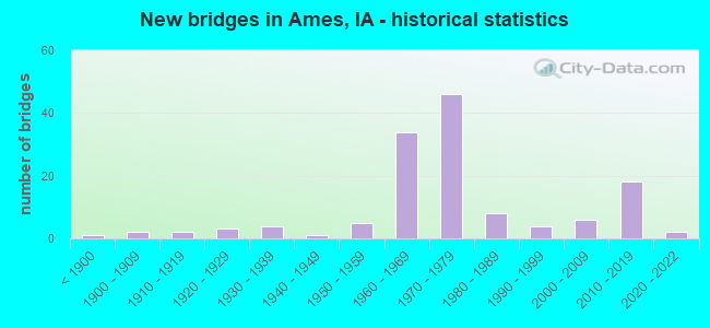
- New bridges - historical statistics
- 1Before 1900
- 21900-1909
- 21910-1919
- 31920-1929
- 41930-1939
- 11940-1949
- 51950-1959
- 341960-1969
- 461970-1979
- 81980-1989
- 41990-1999
- 62000-2009
- 182010-2019
- 22020-2022
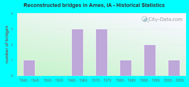
- Reconstructed bridges - Historical Statistics
- 11940-1949
- 01950-1959
- 31960-1969
- 31970-1979
- 11980-1989
- 21990-1999
- 12000-2009
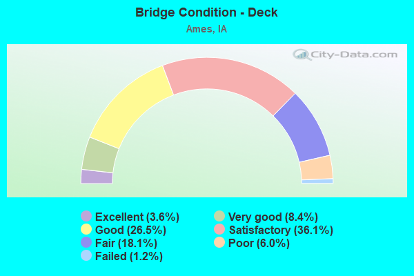
- Bridge Condition - Deck
- 3.6%Excellent
- 8.4%Very good
- 26.5%Good
- 36.1%Satisfactory
- 18.1%Fair
- 6.0%Poor
- 1.2%Failed
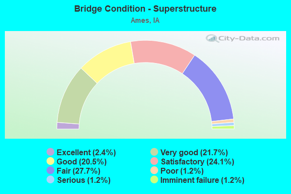
- Bridge Condition - Superstructure
- 2.4%Excellent
- 21.7%Very good
- 20.5%Good
- 24.1%Satisfactory
- 27.7%Fair
- 1.2%Poor
- 1.2%Serious
- 1.2%Imminent failure
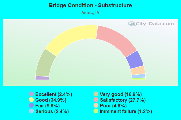
- Bridge Condition - Substructure
- 2.4%Excellent
- 16.9%Very good
- 34.9%Good
- 27.7%Satisfactory
- 9.6%Fair
- 4.8%Poor
- 2.4%Serious
- 1.2%Imminent failure
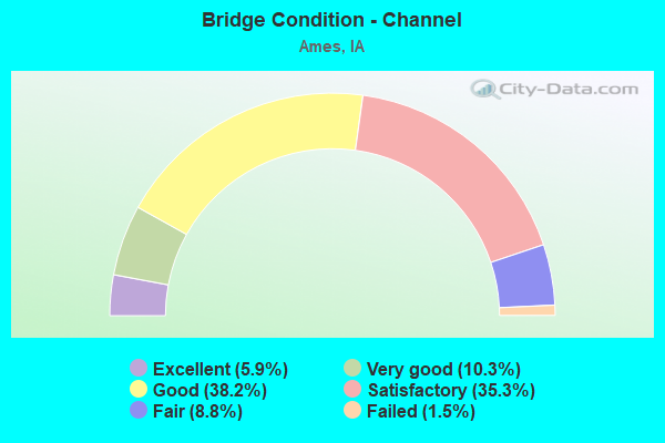
- Bridge Condition - Channel
- 5.9%Excellent
- 10.3%Very good
- 38.2%Good
- 35.3%Satisfactory
- 8.8%Fair
- 1.5%Failed
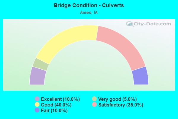
- Bridge Condition - Culverts
- 10.0%Excellent
- 5.0%Very good
- 40.0%Good
- 35.0%Satisfactory
- 10.0%Fair
Find on map >> Show street view
Structure Number: 505505, Location: 0.4 Mi N of S 16th Street (Lat: 42.020675, Lng: -93.620308), Route carried "on" structure: City street , Year Built: 2021, Status: Open, Structure Length: 8.14m (26.71ft), Average Daily Traffic: 4,089 (year 2021), Average Future Daily Traffic: 4,089 (year 2041), Design Load: HL 93, Features Intersected: OVERFLOW CHANNEL, Facility Carried by Structure: S GRAND AVE
Minimum Vertical Clearance: 30+ m (98+ ft), Kilometerpoint: 0.945, Lanes on structure: 2, Owner: City or Municipal Highway Agency, Maintenance Responsibility: Town or Township Highway Agency, Approaching Roadway Width: 9.1m (29.9ft), Material/Design: Prestressed concrete, Design/Construction: Stringer/Multi-beam, Number Of Spans In Main Unit: 3, Length of Maximum Span: 31.1m (102.0ft), Curb or Sidewalk Widths: Left: 3.7m (12.1ft), Right: 1.5m (4.9ft), Curb-To-Curb Width: 9.1m (29.9ft), Out-to-Out Width: 15.5m (50.9ft)
Condition: Deck: Very good, Superstructure: Very good, Substructure: Very good, Channel: Very good, Operating Rating: 53.8 metric tons, Method Used To Determine Operating Rating: Load and Resistance Factor Rating (LRFR) rating reported by rating factor(RF) method using HL-93 loadings, Inventory Rating: 41.5 metric tons, Method Used To Determine Inventory Rating: Load and Resistance Factor Rating (LRFR) rating reported by rating factor(RF) method using HL-93 loadings, Structural Evaluation: Equal to present desirable criteria, Deck Geometry: Meets minimum limits, Waterway Adequacy: Superior to present desirable criteria, Approach Roadway Alignment: Equal to present desirable criteria, Designated Inspection Frequency: Every 24 months, Inspection Date: November 2021, Deck Structure Type: Concrete Cast-file-Place, Wearing Surface/Protective System: Wearing Surface: Monolithic Concrete, Deck Protection: Epoxy Coated Reinforcing
Find on map >> Show street view
Structure Number: 60025, Location: 1.1 MI. W of SR. R-38 (Lat: 42.014050, Lng: -93.698706), Route carried "on" structure: County highway , Year Built: 1971, Status: Open, Structure Length: 8.66m (28.41ft), Average Daily Traffic: 170 (year 2019), Average Future Daily Traffic: 170 (year 2041), Design Load: H 20, Features Intersected: US 30, Facility Carried by Structure: 500TH AVE
Minimum Vertical Clearance: 30+ m (98+ ft), Kilometerpoint: 14.730, Lanes on structure: 2, Lanes under structure: 4, Owner: State Highway Agency, Approaching Roadway Width: 12.8m (42.0ft), Skew: 2 degrees, Material/Design: Prestressed concrete, Design/Construction: Stringer/Multi-beam, Number Of Spans In Main Unit: 4, Length of Maximum Span: 29.0m (95.1ft), Curb or Sidewalk Widths: Left: 0.3m (1.0ft), Right: 0.3m (1.0ft), Curb-To-Curb Width: 9.1m (29.9ft), Out-to-Out Width: 10.2m (33.5ft)
Condition: Deck: Good, Superstructure: Very good, Substructure: Good, Operating Rating: 71.6 metric tons, Method Used To Determine Operating Rating: Load Factor (LF), Inventory Rating: 22.7 metric tons, Method Used To Determine Inventory Rating: Load Factor (LF), Structural Evaluation: Equal to present minimum criteria, Deck Geometry: Equal to present minimum criteria, Underclear: Superior to present desirable criteria, Approach Roadway Alignment: Equal to present minimum criteria, Designated Inspection Frequency: Every 24 months, Inspection Date: October 2021, Deck Structure Type: Concrete Cast-file-Place, Wearing Surface/Protective System: Wearing Surface: Monolithic Concrete
Find on map >> Show street view
Structure Number: 6013, Location: 0.8 MILE WEST OF I-35 (Lat: 42.006289, Lng: -93.586367), Route carried "on" structure: City street , Year Built: 1994, Status: Open, Structure Length: 6.25m (20.51ft), Average Daily Traffic: 5,400 (year 2019), Average Future Daily Traffic: 5,400 (year 2040), Design Load: HS 20, Features Intersected: US 30, Facility Carried by Structure: S DAYTON AVE
Minimum Vertical Clearance: 30+ m (98+ ft), Kilometerpoint: 0.504, Lanes on structure: 2, Lanes under structure: 5, Owner: State Highway Agency, Approaching Roadway Width: 14.6m (47.9ft), Material/Design: Prestressed concrete, Design/Construction: Stringer/Multi-beam, Number Of Spans In Main Unit: 2, Length of Maximum Span: 30.8m (101.0ft), Curb-To-Curb Width: 13.4m (44.0ft), Out-to-Out Width: 14.4m (47.2ft)
Condition: Deck: Excellent, Superstructure: Satisfactory, Substructure: Very good, Operating Rating: 86.7 metric tons, Method Used To Determine Operating Rating: Load Factor (LF), Inventory Rating: 40.8 metric tons, Method Used To Determine Inventory Rating: Load Factor (LF), Structural Evaluation: Equal to present minimum criteria, Deck Geometry: Equal to present minimum criteria, Underclear: Equal to present minimum criteria, Approach Roadway Alignment: Somewhat better than minimum adequacy, Designated Inspection Frequency: Every 24 months, Inspection Date: August 2020, Deck Structure Type: Concrete Cast-file-Place, Wearing Surface/Protective System: Wearing Surface: Monolithic Concrete, Deck Protection: Epoxy Coated Reinforcing
Find on map >> Show street view
Structure Number: 6028, Location: 1.5 MI. E OF E JCT. US 61 (Lat: 41.807042, Lng: -90.539461), Route carried "on" structure: US 30, Year Built: 1970, Status: Open, Structure Length: 5.36m (17.59ft), Average Daily Traffic: 3,100 (year 2020), Truck Traffic: 18%, Average Future Daily Traffic: 3,100 (year 2040), Design Load: HS 20, Features Intersected: S 6TH AVE
Minimum Vertical Clearance: 30+ m (98+ ft), Kilometerpoint: 501.716, Lanes on structure: 2, Lanes under structure: 2, Base Highway Network: Yes, Owner: State Highway Agency, Approaching Roadway Width: 12.2m (40.0ft), Material/Design: Prestressed concrete, Design/Construction: Stringer/Multi-beam, Number Of Spans In Main Unit: 3, Length of Maximum Span: 27.7m (90.9ft), Curb-To-Curb Width: 12.2m (40.0ft), Out-to-Out Width: 13.2m (43.3ft)
Condition: Deck: Satisfactory, Superstructure: Good, Substructure: Good, Operating Rating: 85.6 metric tons, Method Used To Determine Operating Rating: Load Factor (LF), Inventory Rating: 33.1 metric tons, Method Used To Determine Inventory Rating: Load Factor (LF), Structural Evaluation: Better than present minimum criteria, Deck Geometry: Better than present minimum criteria, Underclear: Superior to present desirable criteria, Approach Roadway Alignment: Equal to present desirable criteria, Designated Inspection Frequency: Every 24 months, Inspection Date: December 2020, Deck Structure Type: Concrete Cast-file-Place, Wearing Surface/Protective System: Wearing Surface: Low Slump Concrete
Find on map >> Show street view
Structure Number: 602802, Location: 1.5 MI. E OF E JCT. US 61 (Lat: 41.807264, Lng: -90.538806), Route carried "on" structure: US 30, Year Built: 1970, Status: Open, Structure Length: 5.36m (17.59ft), Average Daily Traffic: 3,100 (year 2020), Truck Traffic: 18%, Average Future Daily Traffic: 3,100 (year 2040), Design Load: HS 20, Features Intersected: S 6TH AVE
Minimum Vertical Clearance: 30+ m (98+ ft), Kilometerpoint: 30.795, Lanes on structure: 2, Lanes under structure: 2, Owner: State Highway Agency, Approaching Roadway Width: 12.2m (40.0ft), Material/Design: Prestressed concrete, Design/Construction: Stringer/Multi-beam, Number Of Spans In Main Unit: 3, Length of Maximum Span: 28.0m (91.9ft), Curb-To-Curb Width: 12.2m (40.0ft), Out-to-Out Width: 13.2m (43.3ft)
Condition: Deck: Satisfactory, Superstructure: Good, Substructure: Good, Operating Rating: 67.3 metric tons, Method Used To Determine Operating Rating: Allowable Stress (AS), Inventory Rating: 27.8 metric tons, Method Used To Determine Inventory Rating: Allowable Stress (AS), Structural Evaluation: Equal to present minimum criteria, Deck Geometry: Better than present minimum criteria, Underclear: Superior to present desirable criteria, Approach Roadway Alignment: Equal to present desirable criteria, Designated Inspection Frequency: Every 24 months, Inspection Date: December 2020, Deck Structure Type: Concrete Cast-file-Place, Wearing Surface/Protective System: Wearing Surface: Low Slump Concrete
Find on map >> Show street view
Structure Number: 60283, Location: 0.7 MI. E OF W JCT US 61 (Lat: 41.816617, Lng: -90.568281), Route carried "on" structure: US 30, Year Built: 1970, Year Reconstructed: 1975, Status: Open, Structure Length: 12.95m (42.49ft), Average Daily Traffic: 6,600 (year 2020), Truck Traffic: 21%, Average Future Daily Traffic: 6,600 (year 2040), Design Load: HS 20, Features Intersected: SILVER CK & UP RR
Minimum Vertical Clearance: 30+ m (98+ ft), Kilometerpoint: 497.711, Lanes on structure: 2, Base Highway Network: Yes, Owner: State Highway Agency, Approaching Roadway Width: 12.2m (40.0ft), Skew: 1 degrees, Material/Design: Prestressed concrete, Design/Construction: Stringer/Multi-beam, Number Of Spans In Main Unit: 6, Length of Maximum Span: 27.7m (90.9ft), Curb-To-Curb Width: 12.2m (40.0ft), Out-to-Out Width: 13.3m (43.6ft)
Condition: Deck: Satisfactory, Superstructure: Fair, Substructure: Satisfactory, Channel: Satisfactory, Operating Rating: 77.5 metric tons, Method Used To Determine Operating Rating: Load Factor (LF), Inventory Rating: 33.1 metric tons, Method Used To Determine Inventory Rating: Load Factor (LF), Structural Evaluation: Somewhat better than minimum adequacy, Deck Geometry: Better than present minimum criteria, Underclear: Superior to present desirable criteria, Waterway Adequacy: Equal to present desirable criteria, Approach Roadway Alignment: Better than present minimum criteria, Designated Inspection Frequency: Every 24 months, Inspection Date: October 2020, Deck Structure Type: Concrete Cast-file-Place, Wearing Surface/Protective System: Wearing Surface: Low Slump Concrete
Find on map >> Show street view
Structure Number: 602832, Location: 0.7 MI. E OF W JCT. US 61 (Lat: 41.815500, Lng: -90.567747), Route carried "on" structure: US 30, Year Built: 1970, Year Reconstructed: 1975, Status: Open, Structure Length: 12.95m (42.49ft), Average Daily Traffic: 6,600 (year 2020), Truck Traffic: 21%, Average Future Daily Traffic: 6,600 (year 2040), Design Load: HS 20, Features Intersected: SILVER CK & UP RR
Minimum Vertical Clearance: 30+ m (98+ ft), Kilometerpoint: 33.719, Lanes on structure: 2, Owner: State Highway Agency, Approaching Roadway Width: 12.2m (40.0ft), Skew: 1 degrees, Material/Design: Prestressed concrete, Design/Construction: Stringer/Multi-beam, Number Of Spans In Main Unit: 6, Length of Maximum Span: 28.0m (91.9ft), Curb-To-Curb Width: 12.2m (40.0ft), Out-to-Out Width: 13.3m (43.6ft)
Condition: Deck: Satisfactory, Superstructure: Fair, Substructure: Satisfactory, Channel: Satisfactory, Operating Rating: 45.4 metric tons, Method Used To Determine Operating Rating: Load Factor (LF), Inventory Rating: 21.8 metric tons, Method Used To Determine Inventory Rating: Load Factor (LF), Structural Evaluation: Somewhat better than minimum adequacy, Deck Geometry: Better than present minimum criteria, Underclear: Superior to present desirable criteria, Waterway Adequacy: Equal to present desirable criteria, Approach Roadway Alignment: Equal to present desirable criteria, Designated Inspection Frequency: Every 24 months, Inspection Date: October 2020, Deck Structure Type: Concrete Cast-file-Place, Wearing Surface/Protective System: Wearing Surface: Low Slump Concrete
Find on map >> Show street view
Structure Number: 60284, Location: 0.9 MI. N OF N JCT US 30 (Lat: 41.838842, Lng: -90.568733), Route carried "on" structure: US 61, Year Built: 1974, Status: Open, Structure Length: 6.37m (20.90ft), Average Daily Traffic: 4,500 (year 2020), Truck Traffic: 24%, Average Future Daily Traffic: 4,500 (year 2041), Design Load: HS 20, Features Intersected: SILVER CREEK
Minimum Vertical Clearance: 30+ m (98+ ft), Kilometerpoint: 227.997, Lanes on structure: 2, Base Highway Network: Yes, Owner: State Highway Agency, Approaching Roadway Width: 12.2m (40.0ft), Material/Design: Prestressed concrete, Design/Construction: Stringer/Multi-beam, Number Of Spans In Main Unit: 3, Length of Maximum Span: 22.3m (73.2ft), Curb-To-Curb Width: 12.2m (40.0ft), Out-to-Out Width: 13.2m (43.3ft)
Condition: Deck: Satisfactory, Superstructure: Good, Substructure: Good, Channel: Satisfactory, Operating Rating: 67.2 metric tons, Method Used To Determine Operating Rating: Allowable Stress (AS), Inventory Rating: 37.9 metric tons, Method Used To Determine Inventory Rating: Allowable Stress (AS), Structural Evaluation: Better than present minimum criteria, Deck Geometry: Better than present minimum criteria, Waterway Adequacy: Equal to present minimum criteria, Approach Roadway Alignment: Equal to present desirable criteria, Designated Inspection Frequency: Every 24 months, Inspection Date: July 2021, Deck Structure Type: Concrete Cast-file-Place, Wearing Surface/Protective System: Wearing Surface: Low Slump Concrete
Find on map >> Show street view
Structure Number: 602842, Location: 0.9 mi. N of N Jct. US 30 (Lat: 41.839431, Lng: -90.569033), Route carried "on" structure: US 61, Year Built: 1974, Status: Open, Structure Length: 6.37m (20.90ft), Average Daily Traffic: 4,500 (year 2020), Truck Traffic: 24%, Average Future Daily Traffic: 4,500 (year 2041), Design Load: HS 20, Features Intersected: SILVER CREEK
Minimum Vertical Clearance: 30+ m (98+ ft), Kilometerpoint: 82.067, Lanes on structure: 2, Owner: State Highway Agency, Approaching Roadway Width: 12.2m (40.0ft), Material/Design: Prestressed concrete, Design/Construction: Stringer/Multi-beam, Number Of Spans In Main Unit: 3, Length of Maximum Span: 22.3m (73.2ft), Curb-To-Curb Width: 12.2m (40.0ft), Out-to-Out Width: 13.2m (43.3ft)
Condition: Deck: Satisfactory, Superstructure: Good, Substructure: Good, Channel: Good, Operating Rating: 65.6 metric tons, Method Used To Determine Operating Rating: Allowable Stress (AS), Inventory Rating: 44.0 metric tons, Method Used To Determine Inventory Rating: Allowable Stress (AS), Structural Evaluation: Better than present minimum criteria, Deck Geometry: Better than present minimum criteria, Waterway Adequacy: Better than present minimum criteria, Approach Roadway Alignment: Equal to present desirable criteria, Designated Inspection Frequency: Every 24 months, Inspection Date: July 2021, Deck Structure Type: Concrete Cast-file-Place, Wearing Surface/Protective System: Wearing Surface: Low Slump Concrete
Find on map >> Show street view
Structure Number: 60285, Location: 1.1 MI N OF N JCT. US 30 (Lat: 41.841747, Lng: -90.568517), Route carried "on" structure: US 61, Year Built: 1974, Status: Open, Structure Length: 4.60m (15.09ft), Average Daily Traffic: 4,500 (year 2020), Truck Traffic: 24%, Average Future Daily Traffic: 4,500 (year 2041), Design Load: HS 20, Features Intersected: 225TH STREET
Minimum Vertical Clearance: 30+ m (98+ ft), Kilometerpoint: 228.319, Lanes on structure: 2, Lanes under structure: 2, Base Highway Network: Yes, Owner: State Highway Agency, Approaching Roadway Width: 12.2m (40.0ft), Skew: 1 degrees, Material/Design: Prestressed concrete, Design/Construction: Stringer/Multi-beam, Number Of Spans In Main Unit: 3, Length of Maximum Span: 17.4m (57.1ft), Curb-To-Curb Width: 12.2m (40.0ft), Out-to-Out Width: 13.2m (43.3ft)
Condition: Deck: Satisfactory, Superstructure: Very good, Substructure: Good, Operating Rating: 59.4 metric tons, Method Used To Determine Operating Rating: Allowable Stress (AS), Inventory Rating: 43.1 metric tons, Method Used To Determine Inventory Rating: Allowable Stress (AS), Structural Evaluation: Better than present minimum criteria, Deck Geometry: Better than present minimum criteria, Underclear: Equal to present minimum criteria, Approach Roadway Alignment: Equal to present desirable criteria, Designated Inspection Frequency: Every 24 months, Inspection Date: July 2021, Deck Structure Type: Concrete Cast-file-Place, Wearing Surface/Protective System: Wearing Surface: Low Slump Concrete
Find on map >> Show street view
Structure Number: 60286, Location: AT N JCT. OF US 30 (Lat: 41.825292, Lng: -90.569281), Route carried "on" structure: US 30, Year Built: 1970, Status: Open, Structure Length: 7.83m (25.69ft), Average Daily Traffic: 605 (year 2020), Truck Traffic: 26%, Average Future Daily Traffic: 605 (year 2041), Design Load: HS 20, Features Intersected: US 30 & W.11TH ST, Facility Carried by Structure: NB US 61
Minimum Vertical Clearance: 30+ m (98+ ft), Kilometerpoint: 34.813, Lanes on structure: 3, Lanes under structure: 6, Owner: State Highway Agency, Approaching Roadway Width: 12.2m (40.0ft), Material/Design: Prestressed concrete, Design/Construction: Stringer/Multi-beam, Number Of Spans In Main Unit: 4, Length of Maximum Span: 23.5m (77.1ft), Curb-To-Curb Width: 16.3m (53.5ft), Out-to-Out Width: 17.4m (57.1ft)
Condition: Deck: Fair, Superstructure: Good, Substructure: Good, Operating Rating: 64.7 metric tons, Method Used To Determine Operating Rating: Allowable Stress (AS), Inventory Rating: 44.0 metric tons, Method Used To Determine Inventory Rating: Allowable Stress (AS), Structural Evaluation: Better than present minimum criteria, Deck Geometry: Better than present minimum criteria, Underclear: Superior to present desirable criteria, Approach Roadway Alignment: Equal to present desirable criteria, Designated Inspection Frequency: Every 24 months, Inspection Date: July 2021, Deck Structure Type: Concrete Cast-file-Place, Wearing Surface/Protective System: Wearing Surface: Low Slump Concrete
Find on map >> Show street view
Structure Number: 602862, Location: AT N JCT. OF US 30 (Lat: 41.825967, Lng: -90.569700), Route carried "on" structure: US 61, Year Built: 1970, Status: Open, Structure Length: 7.83m (25.69ft), Average Daily Traffic: 4,200 (year 2020), Truck Traffic: 25%, Average Future Daily Traffic: 4,200 (year 2041), Design Load: HS 20, Features Intersected: US 30 & W 11TH ST
Minimum Vertical Clearance: 30+ m (98+ ft), Kilometerpoint: 83.565, Lanes on structure: 3, Lanes under structure: 6, Owner: State Highway Agency, Approaching Roadway Width: 12.2m (40.0ft), Material/Design: Prestressed concrete, Design/Construction: Stringer/Multi-beam, Number Of Spans In Main Unit: 4, Length of Maximum Span: 23.5m (77.1ft), Curb-To-Curb Width: 16.3m (53.5ft), Out-to-Out Width: 17.4m (57.1ft)
Condition: Deck: Satisfactory, Superstructure: Good, Substructure: Good, Operating Rating: 65.6 metric tons, Method Used To Determine Operating Rating: Allowable Stress (AS), Inventory Rating: 44.9 metric tons, Method Used To Determine Inventory Rating: Allowable Stress (AS), Structural Evaluation: Better than present minimum criteria, Deck Geometry: Better than present minimum criteria, Underclear: Superior to present desirable criteria, Approach Roadway Alignment: Equal to present desirable criteria, Designated Inspection Frequency: Every 24 months, Inspection Date: July 2021, Deck Structure Type: Concrete Cast-file-Place, Wearing Surface/Protective System: Wearing Surface: Low Slump Concrete
Find on map >> Show street view
Structure Number: 60452, Location: 0.5 MI.S.OF JCT.US 30 (Lat: 41.802356, Lng: -90.567089), Route carried "on" structure: US 61, Year Built: 1981, Status: Open, Structure Length: 5.85m (19.19ft), Average Daily Traffic: 6,600 (year 2020), Truck Traffic: 17%, Average Future Daily Traffic: 6,600 (year 2041), Design Load: HS 20, Features Intersected: SILVER CREEK
Minimum Vertical Clearance: 30+ m (98+ ft), Kilometerpoint: 223.929, Lanes on structure: 2, Base Highway Network: Yes, Owner: State Highway Agency, Approaching Roadway Width: 12.8m (42.0ft), Skew: 3 degrees, Material/Design: Prestressed concrete, Design/Construction: Stringer/Multi-beam, Number Of Spans In Main Unit: 3, Length of Maximum Span: 21.0m (68.9ft), Curb-To-Curb Width: 12.2m (40.0ft), Out-to-Out Width: 13.2m (43.3ft)
Condition: Deck: Good, Superstructure: Good, Substructure: Good, Channel: Satisfactory, Operating Rating: 63.6 metric tons, Method Used To Determine Operating Rating: Allowable Stress (AS), Inventory Rating: 28.8 metric tons, Method Used To Determine Inventory Rating: Allowable Stress (AS), Structural Evaluation: Better than present minimum criteria, Deck Geometry: Better than present minimum criteria, Waterway Adequacy: Equal to present minimum criteria, Approach Roadway Alignment: Equal to present desirable criteria, Designated Inspection Frequency: Every 24 months, Inspection Date: July 2021, Deck Structure Type: Concrete Cast-file-Place, Wearing Surface/Protective System: Wearing Surface: Monolithic Concrete, Deck Protection: Epoxy Coated Reinforcing
Find on map >> Show street view
Structure Number: 60453, Location: 0.5 MI. S OF JCT.US 30 (Lat: 41.802911, Lng: -90.567367), Route carried "on" structure: US 61, Year Built: 1981, Status: Open, Structure Length: 6.00m (19.69ft), Average Daily Traffic: 6,600 (year 2020), Truck Traffic: 17%, Average Future Daily Traffic: 6,600 (year 2041), Design Load: HS 20, Features Intersected: SILVER CREEK
Minimum Vertical Clearance: 30+ m (98+ ft), Kilometerpoint: 86.139, Lanes on structure: 3, Owner: State Highway Agency, Approaching Roadway Width: 12.8m (42.0ft), Skew: 3 degrees, Material/Design: Prestressed concrete, Design/Construction: Stringer/Multi-beam, Number Of Spans In Main Unit: 3, Length of Maximum Span: 21.0m (68.9ft), Curb-To-Curb Width: 16.2m (53.1ft), Out-to-Out Width: 17.1m (56.1ft)
Condition: Deck: Good, Superstructure: Very good, Substructure: Good, Channel: Satisfactory, Operating Rating: 65.5 metric tons, Method Used To Determine Operating Rating: Allowable Stress (AS), Inventory Rating: 24.9 metric tons, Method Used To Determine Inventory Rating: Allowable Stress (AS), Structural Evaluation: Equal to present minimum criteria, Deck Geometry: Better than present minimum criteria, Waterway Adequacy: Equal to present minimum criteria, Approach Roadway Alignment: Equal to present desirable criteria, Designated Inspection Frequency: Every 24 months, Inspection Date: July 2021, Deck Structure Type: Concrete Cast-file-Place, Wearing Surface/Protective System: Wearing Surface: Monolithic Concrete, Deck Protection: Epoxy Coated Reinforcing
Find on map >> Show street view
Structure Number: 605765, Location: AT JUNCTION US 30 (Lat: 42.008861, Lng: -93.568594), Route carried "on" structure: Ramp Interstate 35, Year Built: 1964, Status: Open, Structure Length: 0.73m (2.40ft), Average Daily Traffic: 1,480 (year 2020), Truck Traffic: 17%, Average Future Daily Traffic: 1,480 (year 2041), Design Load: HS 20, Features Intersected: DRAINAGE DITCH
Minimum Vertical Clearance: 30+ m (98+ ft), Kilometerpoint: 0.404, Lanes on structure: 1, Owner: State Highway Agency, Approaching Roadway Width: 9.1m (29.9ft), Skew: 3 degrees, Material/Design: Concrete continuous, Design/Construction: Culvert, Number Of Spans In Main Unit: 2, Length of Maximum Span: 3.7m (12.1ft)
Condition: Channel: Good, Culverts: Satisfactory, Operating Rating: 27.8 metric tons, Method Used To Determine Operating Rating: Load Factor (LF), Inventory Rating: 16.7 metric tons, Method Used To Determine Inventory Rating: Load Factor (LF), Structural Evaluation: Meets minimum limits, Waterway Adequacy: Equal to present minimum criteria, Approach Roadway Alignment: Somewhat better than minimum adequacy, Designated Inspection Frequency: Every 24 months, Inspection Date: October 2021
Find on map >> Show street view
Structure Number: 60713, Location: 0.3 mi. W of E Jct. US 61 (Lat: 41.812600, Lng: -90.567950), Route carried "on" structure: City street , Year Built: 1975, Status: Open, Structure Length: 8.20m (26.90ft), Average Daily Traffic: 540 (year 2018), Average Future Daily Traffic: 540 (year 2040), Design Load: H 20, Features Intersected: US 30, Facility Carried by Structure: CO RD Y 62
Minimum Vertical Clearance: 30+ m (98+ ft), Kilometerpoint: 0.026, Lanes on structure: 2, Lanes under structure: 5, Owner: State Highway Agency, Approaching Roadway Width: 9.8m (32.2ft), Skew: 1 degrees, Material/Design: Prestressed concrete, Design/Construction: Stringer/Multi-beam, Number Of Spans In Main Unit: 4, Length of Maximum Span: 27.7m (90.9ft), Curb or Sidewalk Widths: Left: 0.3m (1.0ft), Right: 0.3m (1.0ft), Curb-To-Curb Width: 9.1m (29.9ft), Out-to-Out Width: 10.2m (33.5ft)
Condition: Deck: Satisfactory, Superstructure: Satisfactory, Substructure: Good, Operating Rating: 69.7 metric tons, Method Used To Determine Operating Rating: Load Factor (LF), Inventory Rating: 21.4 metric tons, Method Used To Determine Inventory Rating: Load Factor (LF), Structural Evaluation: Somewhat better than minimum adequacy, Deck Geometry: Equal to present minimum criteria, Underclear: Equal to present minimum criteria, Approach Roadway Alignment: Better than present minimum criteria, Designated Inspection Frequency: Every 24 months, Inspection Date: December 2020, Deck Structure Type: Concrete Cast-file-Place, Wearing Surface/Protective System: Wearing Surface: Monolithic Concrete
Find on map >> Show street view
Structure Number: 60714, Location: At E jct. of US 61 (Lat: 41.808656, Lng: -90.567467), Route carried "on" structure: US 30, Year Built: 1975, Status: Open, Structure Length: 8.69m (28.51ft), Average Daily Traffic: 1,480 (year 2020), Truck Traffic: 28%, Average Future Daily Traffic: 1,480 (year 2041), Design Load: HS 20, Features Intersected: US 30 & US 61
Minimum Vertical Clearance: 30+ m (98+ ft), Kilometerpoint: 499.376, Lanes on structure: 2, Lanes under structure: 5, Base Highway Network: Yes, Owner: State Highway Agency, Approaching Roadway Width: 15.2m (49.9ft), Skew: 31 degrees, Material/Design: Steel continuous, Design/Construction: Stringer/Multi-beam, Number Of Spans In Main Unit: 4, Length of Maximum Span: 26.8m (87.9ft), Curb-To-Curb Width: 14.6m (47.9ft), Out-to-Out Width: 15.7m (51.5ft)
Condition: Deck: Satisfactory, Superstructure: Good, Substructure: Good, Operating Rating: 46.1 metric tons, Method Used To Determine Operating Rating: Load Factor (LF), Inventory Rating: 27.6 metric tons, Method Used To Determine Inventory Rating: Load Factor (LF), Structural Evaluation: Equal to present minimum criteria, Deck Geometry: Superior to present desirable criteria, Underclear: Superior to present desirable criteria, Approach Roadway Alignment: Somewhat better than minimum adequacy, Designated Inspection Frequency: Every 24 months, Inspection Date: August 2021, Deck Structure Type: Concrete Cast-file-Place, Wearing Surface/Protective System: Wearing Surface: Low Slump Concrete
Find on map >> Show street view
Structure Number: 607216, Location: 1.2 mi. E of Jct. SR Y68 (Lat: 41.807575, Lng: -90.515028), Route carried "on" structure: US 30, Year Built: 1974, Status: Open, Structure Length: 0.67m (2.20ft), Average Daily Traffic: 8,200 (year 2020), Truck Traffic: 16%, Average Future Daily Traffic: 8,200 (year 2040), Design Load: HS 20, Features Intersected: DRAINAGE DITCH
Minimum Vertical Clearance: 30+ m (98+ ft), Kilometerpoint: 503.749, Lanes on structure: 4, Base Highway Network: Yes, Owner: State Highway Agency, Approaching Roadway Width: 12.2m (40.0ft), Skew: 21 degrees, Material/Design: Concrete continuous, Design/Construction: Culvert, Number Of Spans In Main Unit: 2, Length of Maximum Span: 3.0m (9.8ft)
Condition: Channel: Satisfactory, Culverts: Satisfactory, Operating Rating: 67.2 metric tons, Method Used To Determine Operating Rating: Load Factor (LF), Inventory Rating: 40.3 metric tons, Method Used To Determine Inventory Rating: Load Factor (LF), Structural Evaluation: Equal to present minimum criteria, Waterway Adequacy: Better than present minimum criteria, Approach Roadway Alignment: Equal to present desirable criteria, Designated Inspection Frequency: Every 24 months, Inspection Date: December 2020
Find on map >> Show street view
Structure Number: 69955, Location: 0.1 mi. N of Lincolnway (Lat: 42.025461, Lng: -93.639008), Route carried "on" structure: City street , Year Built: 1973, Status: Open, Structure Length: 0.76m (2.49ft), Average Daily Traffic: 5,100 (year 2019), Average Future Daily Traffic: 5,100 (year 2041), Design Load: HS 20, Features Intersected: COLLEGE CREEK, Facility Carried by Structure: BEACH ROAD
Minimum Vertical Clearance: 30+ m (98+ ft), Kilometerpoint: 0.227, Lanes on structure: 2, Owner: State Agenciy, Maintenance Responsibility: State Highway Agency, Approaching Roadway Width: 13.4m (44.0ft), Material/Design: Concrete continuous, Design/Construction: Culvert, Number Of Spans In Main Unit: 2, Length of Maximum Span: 3.7m (12.1ft), Curb or Sidewalk Widths: Left: 0.0m, Right: 2.4m (7.9ft)
Condition: Channel: Good, Culverts: Good, Operating Rating: 48.4 metric tons, Method Used To Determine Operating Rating: Load Factor (LF), Inventory Rating: 29.0 metric tons, Method Used To Determine Inventory Rating: Load Factor (LF), Structural Evaluation: Better than present minimum criteria, Waterway Adequacy: Better than present minimum criteria, Approach Roadway Alignment: Equal to present desirable criteria, Designated Inspection Frequency: Every 24 months, Inspection Date: August 2021
Find on map >> Show street view
Structure Number: 70068, Location: 1.9 mi. S of US 30 (Lat: 41.979850, Lng: -93.570481), Route carried "on" structure: Interstate 35, Year Built: 2017, Status: Open, Structure Length: 1.98m (6.50ft), Average Daily Traffic: 38,600 (year 2020), Truck Traffic: 21%, Average Future Daily Traffic: 38,600 (year 2041), Design Load: HL 93, Features Intersected: SOUTH SKUNK RVR OVERFLOW
Minimum Vertical Clearance: 30+ m (98+ ft), Kilometerpoint: 176.696, Lanes on structure: 4, Base Highway Network: Yes, Owner: State Highway Agency, Approaching Roadway Width: 14.6m (47.9ft), Skew: 20 degrees, Material/Design: Concrete, Design/Construction: Culvert, Number Of Spans In Main Unit: 4, Length of Maximum Span: 4.6m (15.1ft)
Condition: Channel: Excellent, Culverts: Excellent, Operating Rating: 43.7 metric tons, Method Used To Determine Operating Rating: Load and Resistance Factor Rating (LRFR) rating reported by rating factor(RF) method using HL-93 loadings, Inventory Rating: 33.7 metric tons, Method Used To Determine Inventory Rating: Load and Resistance Factor Rating (LRFR) rating reported by rating factor(RF) method using HL-93 loadings, Structural Evaluation: Superior to present desirable criteria, Waterway Adequacy: Superior to present desirable criteria, Approach Roadway Alignment: Equal to present desirable criteria, Designated Inspection Frequency: Every 24 months, Inspection Date: July 2021
Find on map >> Show street view
Structure Number: 700825, Location: I-35 TO US 30 INTERCHANGE (Lat: 42.005014, Lng: -93.570247), Route carried "on" structure: Ramp Interstate 35, Year Built: 2019, Status: Open, Structure Length: 51.79m (169.91ft), Average Daily Traffic: 6,700 (year 2020), Truck Traffic: 12%, Average Future Daily Traffic: 6,700 (year 2040), Design Load: HL 93, Features Intersected: I 35 & US 30
Minimum Vertical Clearance: 30+ m (98+ ft), Kilometerpoint: 0.301, Lanes on structure: 2, Lanes under structure: 10, Owner: State Highway Agency, Approaching Roadway Width: 12.2m (40.0ft), Material/Design: Steel continuous, Design/Construction: Stringer/Multi-beam, Number Of Spans In Main Unit: 7, Length of Maximum Span: 82.6m (271.0ft), Curb-To-Curb Width: 11.0m (36.1ft), Out-to-Out Width: 12.1m (39.7ft)
Condition: Deck: Excellent, Superstructure: Excellent, Substructure: Excellent, Operating Rating: 47.6 metric tons, Method Used To Determine Operating Rating: Load and Resistance Factor Rating (LRFR) rating reported by rating factor(RF) method using HL-93 loadings, Inventory Rating: 36.6 metric tons, Method Used To Determine Inventory Rating: Load and Resistance Factor Rating (LRFR) rating reported by rating factor(RF) method using HL-93 loadings, Structural Evaluation: Superior to present desirable criteria, Deck Geometry: Better than present minimum criteria, Underclear: Somewhat better than minimum adequacy, Approach Roadway Alignment: Equal to present desirable criteria, Designated Inspection Frequency: Every 24 months, Inspection Date: April 2020, Deck Structure Type: Concrete Cast-file-Place, Wearing Surface/Protective System: Wearing Surface: Monolithic Concrete, Deck Protection: Epoxy Coated Reinforcing
Find on map >> Show street view
Structure Number: 15225, Location: At Jct. U.S. 30 (Lat: 42.022192, Lng: -93.725719), Route carried "under" structure: US 30, Year Built: 1972, Structure Length: 0. m, Average Daily Traffic: 12,500 (year 2020), Truck Traffic: 12%, Features Intersected: US 30
Minimum Vertical Clearance: 30+ m (98+ ft), Kilometerpoint: 229.006, Lanes on structure: 1, Lanes under structure: 4, Material/Design: Steel continuous, Design/Construction: Stringer/Multi-beam, Length of Maximum Span: 39.6m (129.9ft)
Find on map >> Show street view
Structure Number: 15227, Location: 2.2 MILES WEST OF SR R38 (Lat: 42.019956, Lng: -93.718306), Route carried "under" structure: US 30, Year Built: 1973, Structure Length: 0. m, Average Daily Traffic: 12,500 (year 2020), Truck Traffic: 12%, Features Intersected: US 30, Facility Carried by Structure: X AVENUE
Minimum Vertical Clearance: 30+ m (98+ ft), Kilometerpoint: 229.636, Lanes on structure: 2, Lanes under structure: 4, Material/Design: Prestressed concrete, Design/Construction: Stringer/Multi-beam, Length of Maximum Span: 29.6m (97.1ft)
Find on map >> Show street view
Structure Number: 48682, Location: 1.5 MILES W OF JCT. US 69 (Lat: 42.002756, Lng: -93.639756), Route carried "under" structure: City street , Year Built: 1971, Structure Length: 0. m, Average Daily Traffic: 3,700 (year 2019), Features Intersected: UNIVERSITY BLVD, Facility Carried by Structure: EB US 30
Minimum Vertical Clearance: 30+ m (98+ ft), Kilometerpoint: 1.838, Lanes on structure: 2, Lanes under structure: 5, Material/Design: Prestressed concrete, Design/Construction: Stringer/Multi-beam, Length of Maximum Span: 29.6m (97.1ft)
Find on map >> Show street view
Structure Number: 48683, Location: 1.5 MILES W OF JCT US 69 (Lat: 42.003008, Lng: -93.639092), Route carried "under" structure: City street , Year Built: 1971, Structure Length: 0. m, Average Daily Traffic: 3,700 (year 2019), Features Intersected: UNIVERISTY BLVD, Facility Carried by Structure: WB US 30
Minimum Vertical Clearance: 30+ m (98+ ft), Kilometerpoint: 1.860, Lanes on structure: 2, Lanes under structure: 4, Material/Design: Prestressed concrete, Design/Construction: Stringer/Multi-beam, Length of Maximum Span: 29.6m (97.1ft)
Find on map >> Show street view
Structure Number: 4871, Location: AT JCT. OF US 69 (Lat: 42.004817, Lng: -93.610539), Route carried "under" structure: US 69, Year Built: 1963, Structure Length: 0. m, Average Daily Traffic: 11,300 (year 2020), Truck Traffic: 2%, Features Intersected: US 69 & BIKE PATH, Facility Carried by Structure: EB US 30
Minimum Vertical Clearance: 30+ m (98+ ft), Kilometerpoint: 185.229, Lanes on structure: 3, Lanes under structure: 4, Material/Design: Prestressed concrete, Design/Construction: Stringer/Multi-beam, Length of Maximum Span: 19.5m (64.0ft)
Find on map >> Show street view
Structure Number: 4872, Location: AT JCT. OF US 69 (Lat: 42.005075, Lng: -93.609792), Route carried "under" structure: US 69, Year Built: 1963, Structure Length: 0. m, Average Daily Traffic: 11,300 (year 2020), Truck Traffic: 2%, Features Intersected: US 69, Facility Carried by Structure: WB US 30
Minimum Vertical Clearance: 30+ m (98+ ft), Kilometerpoint: 185.255, Lanes on structure: 2, Lanes under structure: 4, Material/Design: Prestressed concrete, Design/Construction: Stringer/Multi-beam, Length of Maximum Span: 19.5m (64.0ft)
Find on map >> Show street view
Structure Number: 4898, Location: 0.1 MILE N OF LINCOLN WAY (Lat: 42.025036, Lng: -93.620392), Route carried "under" structure: US 69, Year Built: 1938, Structure Length: 0. m, Average Daily Traffic: 14,500 (year 2020), Truck Traffic: 2%, Features Intersected: US 69 (GRAND AVE.), Facility Carried by Structure: MAIN ST
Minimum Vertical Clearance: 30+ m (98+ ft), Kilometerpoint: 188.277, Lanes on structure: 2, Lanes under structure: 4, Material/Design: Steel continuous, Design/Construction: Stringer/Multi-beam, Length of Maximum Span: 14.3m (46.9ft)
Find on map >> Show street view
Structure Number: 49201, Location: 2.0 MILES S OF JCT 30/35 (Lat: 41.979417, Lng: -93.571367), Route carried "under" structure: Interstate 35, Year Built: 2017, Structure Length: 0. m, Average Daily Traffic: 38,600 (year 2020), Truck Traffic: 21%, Features Intersected: I 35, Facility Carried by Structure: E57 260TH ST
Minimum Vertical Clearance: 30+ m (98+ ft), Kilometerpoint: 176.650, Lanes on structure: 2, Lanes under structure: 4, Material/Design: Prestressed concrete, Design/Construction: Stringer/Multi-beam, Length of Maximum Span: 35.7m (117.1ft)
Find on map >> Show street view
Structure Number: 4921, Location: AT JUNCTION WITH US 30 (Lat: 42.007361, Lng: -93.571011), Route carried "under" structure: US 30, Year Built: 1964, Structure Length: 0. m, Average Daily Traffic: 6,300 (year 2020), Truck Traffic: 7%, Features Intersected: US 30, Facility Carried by Structure: I 35 NB
Minimum Vertical Clearance: 30+ m (98+ ft), Kilometerpoint: 242.267, Lanes on structure: 3, Lanes under structure: 6, Material/Design: Prestressed concrete, Design/Construction: Stringer/Multi-beam, Length of Maximum Span: 21.0m (68.9ft)
Find on map >> Show street view
Structure Number: 4922, Location: AT JUNCTION WITH US 30 (Lat: 42.008006, Lng: -93.571286), Route carried "under" structure: US 30, Year Built: 1964, Structure Length: 0. m, Average Daily Traffic: 6,050 (year 2020), Truck Traffic: 13%, Features Intersected: US 30, Facility Carried by Structure: I 35 SB
Minimum Vertical Clearance: 30+ m (98+ ft), Kilometerpoint: 242.242, Lanes on structure: 3, Lanes under structure: 6, Material/Design: Prestressed concrete, Design/Construction: Stringer/Multi-beam, Length of Maximum Span: 21.0m (68.9ft)
Find on map >> Show street view
Structure Number: 4927, Location: 1.8 MILES N OF JCT US 30 (Lat: 42.034322, Lng: -93.570350), Route carried "under" structure: City street , Year Built: 1966, Structure Length: 0. m, Average Daily Traffic: 3,950 (year 2019), Features Intersected: 13TH ST, Facility Carried by Structure: I-35 NB
Minimum Vertical Clearance: 30+ m (98+ ft), Kilometerpoint: 2.771, Lanes on structure: 2, Lanes under structure: 4, Material/Design: Prestressed concrete, Design/Construction: Stringer/Multi-beam, Length of Maximum Span: 21.9m (71.9ft)
Find on map >> Show street view
Structure Number: 4928, Location: 1.9 MILES N OF JCT US 30 (Lat: 42.034783, Lng: -93.570581), Route carried "under" structure: City street , Year Built: 1966, Structure Length: 0. m, Average Daily Traffic: 3,950 (year 2019), Features Intersected: 13TH ST, Facility Carried by Structure: I 35 SB
Minimum Vertical Clearance: 30+ m (98+ ft), Kilometerpoint: 2.747, Lanes on structure: 2, Lanes under structure: 4, Material/Design: Prestressed concrete, Design/Construction: Stringer/Multi-beam, Length of Maximum Span: 21.9m (71.9ft)
Find on map >> Show street view
Structure Number: 4929, Location: 4.9 MILES N OF JCT. US 30 (Lat: 42.077928, Lng: -93.567342), Route carried "under" structure: Interstate 35, Year Built: 1966, Structure Length: 0. m, Average Daily Traffic: 24,900 (year 2020), Truck Traffic: 24%, Features Intersected: I-35, Facility Carried by Structure: E29 190TH ST
Minimum Vertical Clearance: 30+ m (98+ ft), Kilometerpoint: 187.598, Lanes on structure: 2, Lanes under structure: 4, Material/Design: Prestressed concrete, Design/Construction: Stringer/Multi-beam, Length of Maximum Span: 21.0m (68.9ft)
Find on map >> Show street view
Structure Number: 493, Location: 2.1 MILES NORTH OF SR E29 (Lat: 42.106650, Lng: -93.558208), Route carried "under" structure: Interstate 35, Year Built: 1967, Structure Length: 0. m, Average Daily Traffic: 25,600 (year 2020), Truck Traffic: 24%, Features Intersected: I-35, Facility Carried by Structure: E23 170TH ST
Minimum Vertical Clearance: 30+ m (98+ ft), Kilometerpoint: 190.931, Lanes on structure: 2, Lanes under structure: 5, Material/Design: Steel continuous, Design/Construction: Stringer/Multi-beam, Length of Maximum Span: 27.7m (90.9ft)
Find on map >> Show street view
Structure Number: 494, Location: 1.0 MI NORTH OF JCT US 30 (Lat: 42.022803, Lng: -93.571689), Route carried "under" structure: Interstate 35, Year Built: 1966, Structure Length: 0. m, Average Daily Traffic: 29,500 (year 2020), Truck Traffic: 24%, Features Intersected: I-35, Facility Carried by Structure: LINCOLN WAY
Minimum Vertical Clearance: 30+ m (98+ ft), Kilometerpoint: 181.466, Lanes on structure: 2, Lanes under structure: 4, Material/Design: Prestressed concrete, Design/Construction: Stringer/Multi-beam, Length of Maximum Span: 20.7m (67.9ft)
Find on map >> Show street view
Structure Number: 314865, Location: AT JUNCTION SR R38 NB (Lat: 42.007961, Lng: -93.678597), Route carried "under" structure: US 30, Year Built: 1971, Structure Length: 0. m, Average Daily Traffic: 6,000 (year 2020), Truck Traffic: 13%, Features Intersected: US 30, Facility Carried by Structure: SR R38
Minimum Vertical Clearance: 30+ m (98+ ft), Kilometerpoint: 233.176, Lanes on structure: 2, Lanes under structure: 5, Material/Design: Prestressed concrete, Design/Construction: Stringer/Multi-beam, Length of Maximum Span: 29.6m (97.1ft)
Find on map >> Show street view
Structure Number: 50066, Location: 1.0 mile East of SR R38 (Lat: 42.006522, Lng: -93.658928), Route carried "under" structure: US 30, Year Built: 1971, Structure Length: 0. m, Average Daily Traffic: 21,600 (year 2020), Truck Traffic: 8%, Features Intersected: US 30, Facility Carried by Structure: STATE AVE
Minimum Vertical Clearance: 30+ m (98+ ft), Kilometerpoint: 234.834, Lanes on structure: 2, Lanes under structure: 4, Material/Design: Prestressed concrete, Design/Construction: Stringer/Multi-beam, Length of Maximum Span: 25.0m (82.0ft)
Find on map >> Show street view
Structure Number: 504465, Location: AT JUNCTION SR R38 (Lat: 42.008906, Lng: -93.678761), Route carried "under" structure: US 30, Year Built: 2001, Structure Length: 0. m, Average Daily Traffic: 6,000 (year 2020), Truck Traffic: 13%, Features Intersected: US 30, Facility Carried by Structure: S DAKOTA R38 SB
Minimum Vertical Clearance: 30+ m (98+ ft), Kilometerpoint: 233.157, Lanes on structure: 2, Lanes under structure: 5, Material/Design: Prestressed concrete, Design/Construction: Stringer/Multi-beam, Length of Maximum Span: 29.6m (97.1ft)
Find on map >> Show street view
Structure Number: 60025, Location: 1.1 MI. W of SR. R-38 (Lat: 42.014050, Lng: -93.698706), Route carried "under" structure: US 30, Year Built: 1971, Structure Length: 0. m, Average Daily Traffic: 13,700 (year 2020), Truck Traffic: 12%, Features Intersected: US 30, Facility Carried by Structure: 500TH AVE
Minimum Vertical Clearance: 30+ m (98+ ft), Kilometerpoint: 231.388, Lanes on structure: 2, Lanes under structure: 4, Material/Design: Prestressed concrete, Design/Construction: Stringer/Multi-beam, Length of Maximum Span: 29.0m (95.1ft)
Find on map >> Show street view
Structure Number: 6013, Location: 0.8 MILE WEST OF I-35 (Lat: 42.006289, Lng: -93.586367), Route carried "under" structure: US 30, Year Built: 1994, Structure Length: 0. m, Average Daily Traffic: 23,300 (year 2020), Truck Traffic: 7%, Features Intersected: US 30, Facility Carried by Structure: S DAYTON AVE
Minimum Vertical Clearance: 30+ m (98+ ft), Kilometerpoint: 240.985, Lanes on structure: 2, Lanes under structure: 5, Material/Design: Prestressed concrete, Design/Construction: Stringer/Multi-beam, Length of Maximum Span: 30.8m (101.0ft)
Find on map >> Show street view
Structure Number: 6028, Location: 1.5 MI. E OF E JCT. US 61 (Lat: 41.807042, Lng: -90.539461), Route carried "under" structure: City street , Year Built: 1970, Structure Length: 0. m, Average Daily Traffic: 2,410 (year 2018), Features Intersected: S 6TH AVE, Facility Carried by Structure: EB US 30
Minimum Vertical Clearance: 30+ m (98+ ft), Kilometerpoint: 0.320, Lanes on structure: 2, Lanes under structure: 2, Material/Design: Prestressed concrete, Design/Construction: Stringer/Multi-beam, Length of Maximum Span: 27.7m (90.9ft)
Find on map >> Show street view
Structure Number: 602802, Location: 1.5 MI. E OF E JCT. US 61 (Lat: 41.807264, Lng: -90.538806), Route carried "under" structure: City street , Year Built: 1970, Structure Length: 0. m, Average Daily Traffic: 2,410 (year 2018), Features Intersected: S 6TH AVE, Facility Carried by Structure: WB US 30
Minimum Vertical Clearance: 30+ m (98+ ft), Kilometerpoint: 0.348, Lanes on structure: 2, Lanes under structure: 2, Material/Design: Prestressed concrete, Design/Construction: Stringer/Multi-beam, Length of Maximum Span: 28.0m (91.9ft)
Find on map >> Show street view
Structure Number: 60285, Location: 1.1 MI N OF N JCT. US 30 (Lat: 41.841747, Lng: -90.568517), Route carried "under" structure: County highway , Year Built: 1974, Structure Length: 0. m, Average Daily Traffic: 80 (year 2014), Truck Traffic: 9%, Features Intersected: 225TH STREET, Facility Carried by Structure: NB US 61
Minimum Vertical Clearance: 30+ m (98+ ft), Kilometerpoint: 13.335, Lanes on structure: 2, Lanes under structure: 2, Material/Design: Prestressed concrete, Design/Construction: Stringer/Multi-beam, Length of Maximum Span: 17.4m (57.1ft)
Find on map >> Show street view
Structure Number: 60286, Location: AT N JCT. OF US 30 (Lat: 41.825292, Lng: -90.569281), Route carried "under" structure: US 30, Year Built: 1970, Structure Length: 0. m, Average Daily Traffic: 565 (year 2020), Truck Traffic: 25%, Features Intersected: US 30 & W.11TH ST, Facility Carried by Structure: NB US 61
Minimum Vertical Clearance: 30+ m (98+ ft), Kilometerpoint: 35.351, Lanes on structure: 3, Lanes under structure: 6, Material/Design: Prestressed concrete, Design/Construction: Stringer/Multi-beam, Length of Maximum Span: 23.5m (77.1ft)
Find on map >> Show street view
Structure Number: 60286, Location: AT N JCT. OF US 30 (Lat: 41.825292, Lng: -90.569281), Route carried "under" structure: City street , Year Built: 1970, Structure Length: 0. m, Average Daily Traffic: 1,630 (year 2018), Features Intersected: US 30 & W.11TH ST, Facility Carried by Structure: NB US 61
Minimum Vertical Clearance: 30+ m (98+ ft), Kilometerpoint: 3.304, Lanes on structure: 3, Lanes under structure: 6, Material/Design: Prestressed concrete, Design/Construction: Stringer/Multi-beam, Length of Maximum Span: 23.5m (77.1ft)
Find on map >> Show street view
Structure Number: 602862, Location: AT N JCT. OF US 30 (Lat: 41.825967, Lng: -90.569700), Route carried "under" structure: US 30, Year Built: 1970, Structure Length: 0. m, Average Daily Traffic: 1,315 (year 2020), Truck Traffic: 12%, Features Intersected: US 30 & W 11TH ST, Facility Carried by Structure: SB US 61
Minimum Vertical Clearance: 30+ m (98+ ft), Kilometerpoint: 35.380, Lanes on structure: 3, Lanes under structure: 6, Material/Design: Prestressed concrete, Design/Construction: Stringer/Multi-beam, Length of Maximum Span: 23.5m (77.1ft)
Find on map >> Show street view
Structure Number: 60713, Location: 0.3 mi. W of E Jct. US 61 (Lat: 41.812600, Lng: -90.567950), Route carried "under" structure: US 30, Year Built: 1975, Structure Length: 0. m, Average Daily Traffic: 13,200 (year 2020), Truck Traffic: 21%, Features Intersected: US 30, Facility Carried by Structure: CO RD Y 62
Minimum Vertical Clearance: 30+ m (98+ ft), Kilometerpoint: 498.148, Lanes on structure: 2, Lanes under structure: 5, Material/Design: Prestressed concrete, Design/Construction: Stringer/Multi-beam, Length of Maximum Span: 27.7m (90.9ft)
Find on map >> Show street view
Structure Number: 60714, Location: At E jct. of US 61 (Lat: 41.808656, Lng: -90.567467), Route carried "under" structure: US 61, Year Built: 1975, Structure Length: 0. m, Average Daily Traffic: 10,200 (year 2020), Truck Traffic: 19%, Features Intersected: US 30 & US 61, Facility Carried by Structure: US 30
Minimum Vertical Clearance: 30+ m (98+ ft), Kilometerpoint: 85.477, Lanes on structure: 2, Lanes under structure: 5, Material/Design: Steel continuous, Design/Construction: Stringer/Multi-beam, Length of Maximum Span: 26.8m (87.9ft)
Find on map >> Show street view
Structure Number: 60714, Location: At E jct. of US 61 (Lat: 41.808656, Lng: -90.567467), Route carried "under" structure: Ramp US 30, Year Built: 1975, Structure Length: 0. m, Average Daily Traffic: 1,480 (year 2020), Truck Traffic: 28%, Features Intersected: US 30 & US 61
Minimum Vertical Clearance: 30+ m (98+ ft), Kilometerpoint: 498.578, Lanes on structure: 2, Lanes under structure: 5, Material/Design: Steel continuous, Design/Construction: Stringer/Multi-beam, Length of Maximum Span: 26.8m (87.9ft)
Find on map >> Show street view
Structure Number: 700825, Location: I-35 TO US 30 INTERCHANGE (Lat: 42.005014, Lng: -93.570247), Route carried "under" structure: Interstate 35, Year Built: 2019, Structure Length: 0. m, Average Daily Traffic: 24,500 (year 2020), Truck Traffic: 26%, Features Intersected: I 35 & US 30
Minimum Vertical Clearance: 30+ m (98+ ft), Kilometerpoint: 179.658, Lanes on structure: 2, Lanes under structure: 10, Material/Design: Steel continuous, Design/Construction: Stringer/Multi-beam, Length of Maximum Span: 82.6m (271.0ft)
Find on map >> Show street view
Structure Number: 700825, Location: I-35 TO US 30 INTERCHANGE (Lat: 42.005014, Lng: -93.570247), Route carried "under" structure: US 30, Year Built: 2019, Structure Length: 0. m, Average Daily Traffic: 12,100 (year 2020), Truck Traffic: 13%, Features Intersected: I 35 & US 30, Facility Carried by Structure: I 35 FLY OVER RAMP
Minimum Vertical Clearance: 30+ m (98+ ft), Kilometerpoint: 242.139, Lanes on structure: 2, Lanes under structure: 10, Material/Design: Steel continuous, Design/Construction: Stringer/Multi-beam, Length of Maximum Span: 82.6m (271.0ft)
Find on map >> Show street view
Structure Number: 700825, Location: I-35 TO US 30 INTERCHANGE (Lat: 42.005014, Lng: -93.570247), Route carried "under" structure: Ramp Interstate 35, Year Built: 2019, Structure Length: 0. m, Average Daily Traffic: 1,840 (year 2020), Truck Traffic: 12%, Features Intersected: I 35 & US 30
Minimum Vertical Clearance: 30+ m (98+ ft), Kilometerpoint: 0.399, Lanes on structure: 2, Lanes under structure: 10, Material/Design: Steel continuous, Design/Construction: Stringer/Multi-beam, Length of Maximum Span: 82.6m (271.0ft)
Find on map >> Show street view
Structure Number: 700825, Location: I-35 TO US 30 INTERCHANGE (Lat: 42.005014, Lng: -93.570247), Route carried "under" structure: Ramp Interstate 35, Year Built: 2019, Structure Length: 0. m, Average Daily Traffic: 1,240 (year 2020), Truck Traffic: 20%, Features Intersected: I 35 & US 30
Minimum Vertical Clearance: 30+ m (98+ ft), Kilometerpoint: 0.084, Lanes on structure: 2, Lanes under structure: 10, Material/Design: Steel continuous, Design/Construction: Stringer/Multi-beam, Length of Maximum Span: 82.6m (271.0ft)