Bridge Statistics for Amory, Mississippi (MS)
Condition, Traffic, Stress, Structural Evaluation, Project Costs
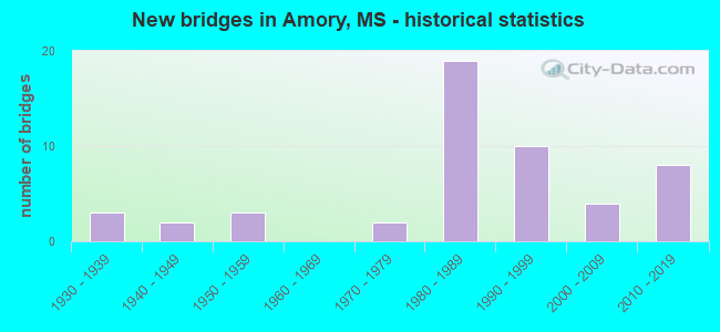
- New bridges - historical statistics
- 31930-1939
- 21940-1949
- 31950-1959
- 21970-1979
- 191980-1989
- 101990-1999
- 42000-2009
- 82010-2019
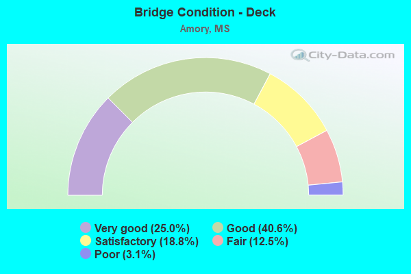
- Bridge Condition - Deck
- 25.0%Very good
- 40.6%Good
- 18.8%Satisfactory
- 12.5%Fair
- 3.1%Poor
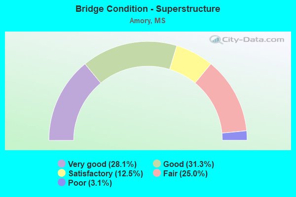
- Bridge Condition - Superstructure
- 28.1%Very good
- 31.3%Good
- 12.5%Satisfactory
- 25.0%Fair
- 3.1%Poor
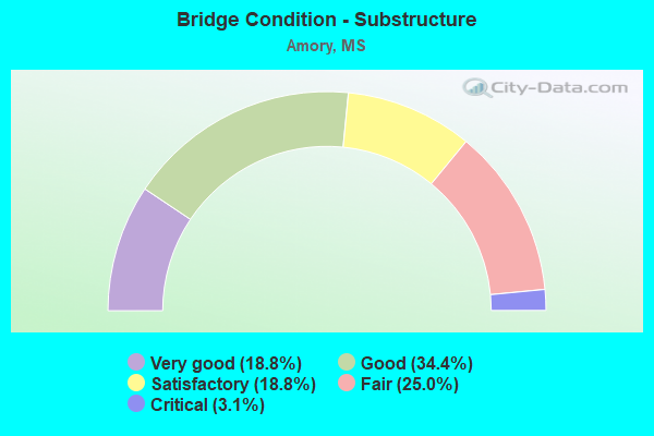
- Bridge Condition - Substructure
- 18.8%Very good
- 34.4%Good
- 18.8%Satisfactory
- 25.0%Fair
- 3.1%Critical
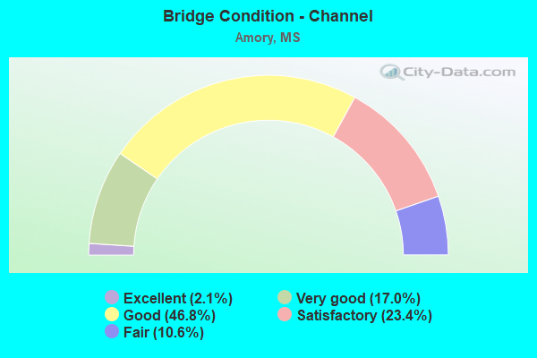
- Bridge Condition - Channel
- 2.1%Excellent
- 17.0%Very good
- 46.8%Good
- 23.4%Satisfactory
- 10.6%Fair
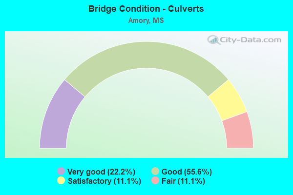
- Bridge Condition - Culverts
- 22.2%Very good
- 55.6%Good
- 11.1%Satisfactory
- 11.1%Fair
Find on map >> Show street view
Structure Number: 21000450770296B, Location: 4.0 MI S CLARKE CL (Lat: 31.791578, Lng: -88.681886), Route carried "on" structure: US 45, Year Built: 2000, Status: Open, Structure Length: 13.47m (44.19ft), Average Daily Traffic: 5,700 (year 2020), Truck Traffic: 23%, Average Future Daily Traffic: 6,100 (year 2040), Design Load: HS 20, Features Intersected: CARSON SAND CREEK
Minimum Vertical Clearance: 30+ m (98+ ft), Kilometerpoint: 45.953, Lanes on structure: 2, Base Highway Network: Yes (Inventory Route: 4, Subroute: 1), Owner: State Highway Agency, Approaching Roadway Width: 12.2m (40.0ft), Material/Design: Prestressed concrete, Design/Construction: Stringer/Multi-beam, Number Of Spans In Main Unit: 1, Number Of Approach Spans: 7, Length of Maximum Span: 36.5m (119.8ft), Curb-To-Curb Width: 12.2m (40.0ft), Out-to-Out Width: 13.1m (43.0ft)
Condition: Deck: Good, Superstructure: Very good, Substructure: Very good, Channel: Good, Operating Rating: 58.2 metric tons, Method Used To Determine Operating Rating: Load Factor (LF), Inventory Rating: 24.8 metric tons, Method Used To Determine Inventory Rating: Load Factor (LF), Structural Evaluation: Equal to present minimum criteria, Deck Geometry: Better than present minimum criteria, Waterway Adequacy: Equal to present desirable criteria, Approach Roadway Alignment: Superior to present desirable criteria, Designated Inspection Frequency: Every 24 months, Inspection Date: September 2021, Deck Structure Type: Concrete Cast-file-Place
Find on map >> Show street view
Structure Number: 21002780480043, Location: 3.5 MI W SR 25 SOUTH (Lat: 33.985622, Lng: -88.552319), Route carried "on" structure: US 278, Year Built: 1996, Status: Open, Structure Length: 31.76m (104.20ft), Average Daily Traffic: 5,800 (year 2020), Truck Traffic: 10%, Average Future Daily Traffic: 8,200 (year 2040), Design Load: HS 20, Features Intersected: TOMBIGBEE RIVER
Minimum Vertical Clearance: 30+ m (98+ ft), Kilometerpoint: 7.213, Lanes on structure: 2, Base Highway Network: Yes (Inventory Route: 27, Subroute: 1), Owner: State Highway Agency, Approaching Roadway Width: 13.4m (44.0ft), Material/Design: Steel continuous, Design/Construction: Stringer/Multi-beam, Number Of Spans In Main Unit: 3, Number Of Approach Spans: 9, Length of Maximum Span: 61.0m (200.1ft), Curb-To-Curb Width: 13.4m (44.0ft), Out-to-Out Width: 14.3m (46.9ft)
Condition: Deck: Good, Superstructure: Good, Substructure: Good, Channel: Good, Operating Rating: 61.9 metric tons, Method Used To Determine Operating Rating: Load Factor (LF), Inventory Rating: 27.1 metric tons, Method Used To Determine Inventory Rating: Load Factor (LF), Structural Evaluation: Equal to present minimum criteria, Deck Geometry: Equal to present minimum criteria, Waterway Adequacy: Equal to present desirable criteria, Approach Roadway Alignment: Equal to present desirable criteria, Designated Inspection Frequency: Every 24 months, Inspection Date: June 2021, Deck Structure Type: Concrete Cast-file-Place
Find on map >> Show street view
Structure Number: 21002780480048, Location: 3.0 MI W SR 25 SOUTH (Lat: 33.984464, Lng: -88.544544), Route carried "on" structure: US 278, Year Built: 1996, Status: Open, Structure Length: 34.19m (112.17ft), Average Daily Traffic: 5,800 (year 2020), Truck Traffic: 10%, Average Future Daily Traffic: 8,200 (year 2040), Design Load: HS 20, Features Intersected: TOMBIGBEE RIVER RELIEF
Minimum Vertical Clearance: 30+ m (98+ ft), Kilometerpoint: 7.944, Lanes on structure: 2, Base Highway Network: Yes (Inventory Route: 27, Subroute: 1), Owner: State Highway Agency, Approaching Roadway Width: 13.4m (44.0ft), Material/Design: Prestressed concrete continuous, Design/Construction: Stringer/Multi-beam, Number Of Spans In Main Unit: 28, Length of Maximum Span: 12.2m (40.0ft), Curb-To-Curb Width: 13.4m (44.0ft), Out-to-Out Width: 14.3m (46.9ft)
Condition: Deck: Good, Superstructure: Good, Substructure: Good, Channel: Good, Operating Rating: 62.3 metric tons, Method Used To Determine Operating Rating: Load Factor (LF), Inventory Rating: 37.3 metric tons, Method Used To Determine Inventory Rating: Load Factor (LF), Structural Evaluation: Better than present minimum criteria, Deck Geometry: Equal to present minimum criteria, Waterway Adequacy: Equal to present desirable criteria, Approach Roadway Alignment: Equal to present desirable criteria, Designated Inspection Frequency: Every 24 months, Inspection Date: June 2021, Deck Structure Type: Concrete Cast-file-Place
Find on map >> Show street view
Structure Number: 2100278048006, Location: 1.8 MI W SR 25 SOUTH (Lat: 33.981606, Lng: -88.523236), Route carried "on" structure: US 278, Year Built: 1981, Status: Open, Structure Length: 57.98m (190.22ft), Average Daily Traffic: 5,800 (year 2020), Truck Traffic: 10%, Average Future Daily Traffic: 8,200 (year 2040), Design Load: HS 20, Features Intersected: TENN TOM WATERWAY
Minimum Vertical Clearance: 30+ m (98+ ft), Kilometerpoint: 9.938, Lanes on structure: 2, Base Highway Network: Yes (Inventory Route: 27, Subroute: 1), Owner: State Highway Agency, Approaching Roadway Width: 14.0m (45.9ft), Navigation Control: Yes ( Vertical Clearance: 15.0m (49.2ft), Horizontal Clearance: 91.0m (298.6ft)), Material/Design: Steel continuous, Design/Construction: Stringer/Multi-beam, Number Of Spans In Main Unit: 3, Number Of Approach Spans: 9, Length of Maximum Span: 121.9m (399.9ft), Curb-To-Curb Width: 12.3m (40.4ft), Out-to-Out Width: 13.2m (43.3ft)
Condition: Deck: Good, Superstructure: Good, Substructure: Good, Channel: Good, Operating Rating: 64.0 metric tons, Method Used To Determine Operating Rating: Load Factor (LF), Inventory Rating: 27.4 metric tons, Method Used To Determine Inventory Rating: Load Factor (LF), Structural Evaluation: Equal to present minimum criteria, Deck Geometry: Somewhat better than minimum adequacy, Waterway Adequacy: Superior to present desirable criteria, Approach Roadway Alignment: Equal to present desirable criteria, Designated Inspection Frequency: Every 24 months, Inspection Date: April 2020, Deck Structure Type: Concrete Cast-file-Place
Find on map >> Show street view
Structure Number: 21002780480072, Location: 0.8 MI W SR 25 SOUTH (Lat: 33.978647, Lng: -88.503197), Route carried "on" structure: US 278, Year Built: 1936, Status: Open, Structure Length: 1.03m (3.38ft), Average Daily Traffic: 8,400 (year 2020), Truck Traffic: 6%, Average Future Daily Traffic: 12,000 (year 2040), Design Load: H 15, Features Intersected: ROUNDHOUSE BRANCH
Minimum Vertical Clearance: 30+ m (98+ ft), Kilometerpoint: 11.821, Lanes on structure: 2, Base Highway Network: Yes (Inventory Route: 27, Subroute: 1), Owner: State Highway Agency, Approaching Roadway Width: 11.0m (36.1ft), Skew: 2 degrees, Material/Design: Concrete, Design/Construction: Culvert, Number Of Spans In Main Unit: 3, Length of Maximum Span: 3.0m (9.8ft)
Condition: Channel: Good, Culverts: Good, Operating Rating: 63.2 metric tons, Method Used To Determine Operating Rating: Load Factor (LF), Inventory Rating: 37.8 metric tons, Method Used To Determine Inventory Rating: Load Factor (LF), Structural Evaluation: Better than present minimum criteria, Waterway Adequacy: Equal to present minimum criteria, Approach Roadway Alignment: Equal to present desirable criteria, Length Of Structure Improvement: 1.65m (5.41ft), Designated Inspection Frequency: Every 24 months, Inspection Date: June 2021, Bridge Improvement Cost: $97,000,000, Roadway Improvement Cost: $10,000,000, Total Project Cost: $146,000,000
Find on map >> Show street view
Structure Number: 21002780480117, Location: 3.2 MI E SR 25 NORTH (Lat: 33.954856, Lng: -88.435806), Route carried "on" structure: US 278, Year Built: 1936, Status: Open, Structure Length: 0.63m (2.07ft), Average Daily Traffic: 3,000 (year 2020), Truck Traffic: 9%, Average Future Daily Traffic: 3,000 (year 2040), Design Load: H 15, Features Intersected: CREEK
Minimum Vertical Clearance: 30+ m (98+ ft), Kilometerpoint: 19.162, Lanes on structure: 2, Base Highway Network: Yes (Inventory Route: 27, Subroute: 1), Owner: State Highway Agency, Approaching Roadway Width: 9.8m (32.2ft), Skew: 3 degrees, Material/Design: Concrete, Design/Construction: Culvert, Number Of Spans In Main Unit: 1, Length of Maximum Span: 5.5m (18.0ft)
Condition: Channel: Good, Culverts: Good, Operating Rating: 43.3 metric tons, Method Used To Determine Operating Rating: Load Factor (LF), Inventory Rating: 25.9 metric tons, Method Used To Determine Inventory Rating: Load Factor (LF), Structural Evaluation: Equal to present minimum criteria, Waterway Adequacy: Equal to present minimum criteria, Approach Roadway Alignment: Equal to present desirable criteria, Designated Inspection Frequency: Every 24 months, Inspection Date: June 2021
Find on map >> Show street view
Structure Number: 2100278048012, Location: 3.5 MI E SR 25 NORTH (Lat: 33.952236, Lng: -88.430558), Route carried "on" structure: US 278, Year Built: 1997, Status: Open, Structure Length: 8.58m (28.15ft), Average Daily Traffic: 3,000 (year 2020), Truck Traffic: 9%, Average Future Daily Traffic: 3,000 (year 2040), Design Load: HS 20, Features Intersected: WEAVER CREEK
Minimum Vertical Clearance: 30+ m (98+ ft), Kilometerpoint: 19.727, Lanes on structure: 2, Base Highway Network: Yes (Inventory Route: 27, Subroute: 1), Owner: State Highway Agency, Approaching Roadway Width: 13.4m (44.0ft), Material/Design: Prestressed concrete, Design/Construction: Stringer/Multi-beam, Number Of Spans In Main Unit: 1, Number Of Approach Spans: 5, Length of Maximum Span: 24.4m (80.1ft), Curb-To-Curb Width: 13.4m (44.0ft), Out-to-Out Width: 14.3m (46.9ft)
Condition: Deck: Good, Superstructure: Fair, Substructure: Good, Channel: Satisfactory, Operating Rating: 56.5 metric tons, Method Used To Determine Operating Rating: Load Factor (LF), Inventory Rating: 28.9 metric tons, Method Used To Determine Inventory Rating: Load Factor (LF), Structural Evaluation: Somewhat better than minimum adequacy, Deck Geometry: Better than present minimum criteria, Waterway Adequacy: Superior to present desirable criteria, Approach Roadway Alignment: Equal to present desirable criteria, Designated Inspection Frequency: Every 24 months, Inspection Date: June 2021, Deck Structure Type: Concrete Cast-file-Place
Find on map >> Show street view
Structure Number: 21002780480189, Location: 10.6 MI E SR 25 NORTH (Lat: 33.899178, Lng: -88.332128), Route carried "on" structure: US 278, Year Built: 1998, Status: Open, Structure Length: 5.39m (17.68ft), Average Daily Traffic: 2,300 (year 2020), Truck Traffic: 13%, Average Future Daily Traffic: 2,300 (year 2040), Design Load: HS 20, Features Intersected: BURLINGTON NORTHERN
Minimum Vertical Clearance: 30+ m (98+ ft), Kilometerpoint: 30.798, Lanes on structure: 2, Base Highway Network: Yes (Inventory Route: 27, Subroute: 1), Owner: State Highway Agency, Approaching Roadway Width: 13.4m (44.0ft), Skew: 3 degrees, Material/Design: Prestressed concrete continuous, Design/Construction: Stringer/Multi-beam, Number Of Spans In Main Unit: 3, Length of Maximum Span: 20.7m (67.9ft), Curb-To-Curb Width: 13.4m (44.0ft), Out-to-Out Width: 14.3m (46.9ft)
Condition: Deck: Good, Superstructure: Very good, Substructure: Good, Channel: Very good, Operating Rating: 67.8 metric tons, Method Used To Determine Operating Rating: Load Factor (LF), Inventory Rating: 38.1 metric tons, Method Used To Determine Inventory Rating: Load Factor (LF), Structural Evaluation: Better than present minimum criteria, Deck Geometry: Better than present minimum criteria, Underclear: Superior to present desirable criteria, Approach Roadway Alignment: Equal to present desirable criteria, Designated Inspection Frequency: Every 24 months, Inspection Date: Febuary 2021, Deck Structure Type: Concrete Cast-file-Place
Find on map >> Show street view
Structure Number: 31000060481482, Location: 1.2 MI W SR 371 (Lat: 34.031411, Lng: -88.536956), Route carried "on" structure: State highway 6, Year Built: 1959, Status: Open, Structure Length: 4.88m (16.01ft), Average Daily Traffic: 4,400 (year 2020), Truck Traffic: 14%, Average Future Daily Traffic: 4,400 (year 2040), Design Load: H 15, Features Intersected: RELIEF
Minimum Vertical Clearance: 30+ m (98+ ft), Kilometerpoint: 8.867, Lanes on structure: 2, Base Highway Network: Yes (, Subroute: 1), Owner: State Highway Agency, Approaching Roadway Width: 11.3m (37.1ft), Material/Design: Concrete, Design/Construction: Tee Beam, Number Of Spans In Main Unit: 1, Number Of Approach Spans: 4, Length of Maximum Span: 12.2m (40.0ft), Curb or Sidewalk Widths: Left: 0.5m (1.6ft), Right: 0.5m (1.6ft), Curb-To-Curb Width: 7.9m (25.9ft), Out-to-Out Width: 8.4m (27.6ft)
Condition: Deck: Satisfactory, Superstructure: Satisfactory, Substructure: Satisfactory, Channel: Good, Operating Rating: 38.1 metric tons, Method Used To Determine Operating Rating: Load Factor (LF), Inventory Rating: 22.9 metric tons, Method Used To Determine Inventory Rating: Load Factor (LF), Structural Evaluation: Equal to present minimum criteria, Deck Geometry: High priority of corrective action, Waterway Adequacy: Equal to present minimum criteria, Approach Roadway Alignment: Equal to present desirable criteria, Length Of Structure Improvement: 6.31m (20.70ft), Designated Inspection Frequency: Every 24 months, Inspection Date: May 2020, Bridge Improvement Cost: $576,000,000, Roadway Improvement Cost: $58,000,000, Total Project Cost: $999,999,000, Deck Structure Type: Concrete Cast-file-Place, Wearing Surface/Protective System: Wearing Surface: Bituminous
Find on map >> Show street view
Structure Number: 31000060481539, Location: 1.4 MI W SR 25 (Lat: 34.012297, Lng: -88.514483), Route carried "on" structure: State highway 6, Year Built: 1958, Year Reconstructed: 1991, Status: Open, Structure Length: 26.82m (87.99ft), Average Daily Traffic: 6,400 (year 2020), Truck Traffic: 14%, Average Future Daily Traffic: 6,400 (year 2040), Design Load: HS 15, Features Intersected: TOMBIGBEE RIVER
Minimum Vertical Clearance: 30+ m (98+ ft), Kilometerpoint: 11.835, Lanes on structure: 2, Base Highway Network: Yes (, Subroute: 1), Owner: State Highway Agency, Approaching Roadway Width: 11.3m (37.1ft), Material/Design: Concrete continuous, Design/Construction: Box Beam or Girders - Single/Spread, Number Of Spans In Main Unit: 3, Number Of Approach Spans: 32, Length of Maximum Span: 27.4m (89.9ft), Curb or Sidewalk Widths: Left: 0.5m (1.6ft), Right: 0.5m (1.6ft), Curb-To-Curb Width: 7.9m (25.9ft), Out-to-Out Width: 8.9m (29.2ft)
Condition: Deck: Satisfactory, Superstructure: Satisfactory, Substructure: Fair, Channel: Fair, Operating Rating: 55.3 metric tons, Method Used To Determine Operating Rating: Load Factor (LF), Inventory Rating: 33.1 metric tons, Method Used To Determine Inventory Rating: Load Factor (LF), Structural Evaluation: Somewhat better than minimum adequacy, Deck Geometry: High priority of corrective action, Waterway Adequacy: Equal to present minimum criteria, Approach Roadway Alignment: Equal to present desirable criteria, Length Of Structure Improvement: 32.11m (105.35ft), Designated Inspection Frequency: Every 24 months, Underwater Inspection Frequency: Every 60 months, Inspection Date: May 2020, Underwater Inspection Date: January 2022, Bridge Improvement Cost: $999,999,000, Roadway Improvement Cost: $321,000,000, Total Project Cost: $999,999,000, Deck Structure Type: Concrete Cast-file-Place, Wearing Surface/Protective System: Wearing Surface: Bituminous
Find on map >> Show street view
Structure Number: 31000060481542, Location: 1.0 MI W SR 25 (Lat: 34.007325, Lng: -88.507656), Route carried "on" structure: State highway 6, Year Built: 1981, Status: Open, Structure Length: 9.80m (32.15ft), Average Daily Traffic: 6,400 (year 2020), Truck Traffic: 14%, Average Future Daily Traffic: 6,400 (year 2040), Design Load: HS 20, Features Intersected: TOMBIGBEE RELIEF
Minimum Vertical Clearance: 30+ m (98+ ft), Kilometerpoint: 12.672, Lanes on structure: 2, Base Highway Network: Yes (, Subroute: 1), Owner: State Highway Agency, Approaching Roadway Width: 14.0m (45.9ft), Material/Design: Prestressed concrete continuous, Design/Construction: Stringer/Multi-beam, Number Of Spans In Main Unit: 8, Length of Maximum Span: 12.2m (40.0ft), Curb-To-Curb Width: 12.3m (40.4ft), Out-to-Out Width: 13.2m (43.3ft)
Condition: Deck: Good, Superstructure: Good, Substructure: Good, Channel: Very good, Operating Rating: 54.9 metric tons, Method Used To Determine Operating Rating: Load Factor (LF), Inventory Rating: 32.8 metric tons, Method Used To Determine Inventory Rating: Load Factor (LF), Structural Evaluation: Better than present minimum criteria, Deck Geometry: Somewhat better than minimum adequacy, Waterway Adequacy: Equal to present minimum criteria, Approach Roadway Alignment: Equal to present desirable criteria, Designated Inspection Frequency: Every 24 months, Inspection Date: May 2021, Deck Structure Type: Concrete Cast-file-Place
Find on map >> Show street view
Structure Number: 31000060481544, Location: 0.7 MI W SR 25 (Lat: 34.003206, Lng: -88.503558), Route carried "on" structure: State highway 6, Year Built: 1981, Status: Open, Structure Length: 61.03m (200.23ft), Average Daily Traffic: 6,400 (year 2020), Truck Traffic: 14%, Average Future Daily Traffic: 6,400 (year 2040), Design Load: HS 20, Features Intersected: TENN TOM WATERWAY
Minimum Vertical Clearance: 30+ m (98+ ft), Kilometerpoint: 13.267, Lanes on structure: 2, Lanes under structure: 1, Base Highway Network: Yes (, Subroute: 1), Owner: State Highway Agency, Approaching Roadway Width: 14.0m (45.9ft), Navigation Control: Yes ( Vertical Clearance: 16.0m (52.5ft), Horizontal Clearance: 91.0m (298.6ft)), Material/Design: Steel continuous, Design/Construction: Stringer/Multi-beam, Number Of Spans In Main Unit: 3, Number Of Approach Spans: 10, Length of Maximum Span: 121.9m (399.9ft), Curb-To-Curb Width: 12.3m (40.4ft), Out-to-Out Width: 13.2m (43.3ft)
Condition: Deck: Satisfactory, Superstructure: Good, Substructure: Good, Channel: Very good, Operating Rating: 64.0 metric tons, Method Used To Determine Operating Rating: Load Factor (LF), Inventory Rating: 27.4 metric tons, Method Used To Determine Inventory Rating: Load Factor (LF), Structural Evaluation: Equal to present minimum criteria, Deck Geometry: Somewhat better than minimum adequacy, Waterway Adequacy: Superior to present desirable criteria, Approach Roadway Alignment: Equal to present desirable criteria, Designated Inspection Frequency: Every 24 months, Inspection Date: April 2020, Deck Structure Type: Concrete Cast-file-Place
Find on map >> Show street view
Structure Number: 31000250481325, Location: 3.7 MI S US 278 (Lat: 33.922903, Lng: -88.471708), Route carried "on" structure: State highway 25, Year Built: 2017, Status: Open, Structure Length: 1.13m (3.71ft), Average Daily Traffic: 3,900 (year 2020), Truck Traffic: 6%, Average Future Daily Traffic: 3,900 (year 2040), Design Load: HS 20+Mod, Features Intersected: GREENBRIER BRANCH
Minimum Vertical Clearance: 30+ m (98+ ft), Kilometerpoint: 25.722, Lanes on structure: 2, Base Highway Network: Yes (Inventory Route: 2, Subroute: 2), Owner: State Highway Agency, Approaching Roadway Width: 8.5m (27.9ft), Material/Design: Concrete, Design/Construction: Culvert, Number Of Spans In Main Unit: 2, Length of Maximum Span: 5.5m (18.0ft)
Condition: Channel: Very good, Culverts: Good, Operating Rating: 49.0 metric tons, Method Used To Determine Operating Rating: Load Factor (LF), Inventory Rating: 32.7 metric tons, Method Used To Determine Inventory Rating: Load Factor (LF), Structural Evaluation: Better than present minimum criteria, Waterway Adequacy: Superior to present desirable criteria, Approach Roadway Alignment: Equal to present desirable criteria, Designated Inspection Frequency: Every 24 months, Underwater Inspection Frequency: Every 60 months, Inspection Date: June 2021, Underwater Inspection Date: January 2022
Find on map >> Show street view
Structure Number: 31000250481332A, Location: 3.0 MI S US 278 (Lat: 33.932733, Lng: -88.471111), Route carried "on" structure: State highway 25, Year Built: 2017, Status: Open, Structure Length: 6.47m (21.23ft), Average Daily Traffic: 3,900 (year 2020), Truck Traffic: 6%, Average Future Daily Traffic: 3,900 (year 2040), Design Load: HL 93, Features Intersected: HARMONY ROAD
Minimum Vertical Clearance: 30+ m (98+ ft), Kilometerpoint: 26.815, Lanes on structure: 2, Lanes under structure: 2, Base Highway Network: Yes (Inventory Route: 2, Subroute: 2), Owner: State Highway Agency, Approaching Roadway Width: 12.8m (42.0ft), Material/Design: Prestressed concrete continuous, Design/Construction: Stringer/Multi-beam, Number Of Spans In Main Unit: 3, Length of Maximum Span: 27.4m (89.9ft), Curb-To-Curb Width: 12.8m (42.0ft), Out-to-Out Width: 13.7m (44.9ft)
Condition: Deck: Good, Superstructure: Very good, Substructure: Very good, Operating Rating: 50.2 metric tons, Method Used To Determine Operating Rating: Load and Resistance Factor (LRFR), Inventory Rating: 38.7 metric tons, Method Used To Determine Inventory Rating: Load and Resistance Factor (LRFR), Structural Evaluation: Equal to present desirable criteria, Deck Geometry: Equal to present minimum criteria, Underclear: Superior to present desirable criteria, Approach Roadway Alignment: Equal to present desirable criteria, Designated Inspection Frequency: Every 24 months, Inspection Date: June 2021, Deck Structure Type: Concrete Cast-file-Place
Find on map >> Show street view
Structure Number: 31000250481339A, Location: 2.3 MI S US 278 (Lat: 33.943233, Lng: -88.472636), Route carried "on" structure: State highway 25, Year Built: 2017, Status: Open, Structure Length: 35.41m (116.17ft), Average Daily Traffic: 3,900 (year 2020), Truck Traffic: 6%, Average Future Daily Traffic: 3,900 (year 2040), Design Load: HL 93, Features Intersected: WEAVER CREEK
Minimum Vertical Clearance: 30+ m (98+ ft), Kilometerpoint: 27.991, Lanes on structure: 2, Base Highway Network: Yes (Inventory Route: 2, Subroute: 2), Owner: State Highway Agency, Approaching Roadway Width: 16.5m (54.1ft), Material/Design: Prestressed concrete, Design/Construction: Stringer/Multi-beam, Number Of Spans In Main Unit: 1, Number Of Approach Spans: 27, Length of Maximum Span: 24.4m (80.1ft), Curb-To-Curb Width: 16.5m (54.1ft), Out-to-Out Width: 17.3m (56.8ft)
Condition: Deck: Very good, Superstructure: Very good, Substructure: Very good, Channel: Very good, Operating Rating: 45.7 metric tons, Method Used To Determine Operating Rating: Load and Resistance Factor (LRFR), Inventory Rating: 34.8 metric tons, Method Used To Determine Inventory Rating: Load and Resistance Factor (LRFR), Structural Evaluation: Equal to present desirable criteria, Deck Geometry: Superior to present desirable criteria, Waterway Adequacy: Superior to present desirable criteria, Approach Roadway Alignment: Equal to present desirable criteria, Designated Inspection Frequency: Every 24 months, Inspection Date: June 2021, Deck Structure Type: Concrete Cast-file-Place
Find on map >> Show street view
Structure Number: 31000250481351A, Location: 1.1 MI S US 278 (Lat: 33.959647, Lng: -88.476033), Route carried "on" structure: State highway 25, Year Built: 2017, Status: Open, Structure Length: 8.15m (26.74ft), Average Daily Traffic: 3,900 (year 2020), Truck Traffic: 6%, Average Future Daily Traffic: 3,900 (year 2040), Design Load: HL 93, Features Intersected: COTTON GIN PORT ROAD
Minimum Vertical Clearance: 30+ m (98+ ft), Kilometerpoint: 29.849, Lanes on structure: 2, Lanes under structure: 2, Base Highway Network: Yes (Inventory Route: 2, Subroute: 2), Owner: State Highway Agency, Approaching Roadway Width: 12.8m (42.0ft), Skew: 1 degrees, Material/Design: Prestressed concrete, Design/Construction: Stringer/Multi-beam, Number Of Spans In Main Unit: 3, Length of Maximum Span: 29.0m (95.1ft), Curb-To-Curb Width: 12.8m (42.0ft), Out-to-Out Width: 13.7m (44.9ft)
Condition: Deck: Very good, Superstructure: Very good, Substructure: Very good, Operating Rating: 49.5 metric tons, Method Used To Determine Operating Rating: Load and Resistance Factor (LRFR), Inventory Rating: 38.2 metric tons, Method Used To Determine Inventory Rating: Load and Resistance Factor (LRFR), Structural Evaluation: Equal to present desirable criteria, Deck Geometry: Equal to present minimum criteria, Underclear: Superior to present desirable criteria, Approach Roadway Alignment: Equal to present desirable criteria, Designated Inspection Frequency: Every 24 months, Inspection Date: June 2021, Deck Structure Type: Concrete Cast-file-Place
Find on map >> Show street view
Structure Number: 31000250481353A, Location: 0.8 MI S US 278 (Lat: 33.963608, Lng: -88.474236), Route carried "on" structure: State highway 25, Year Built: 2017, Status: Open, Structure Length: 13.98m (45.87ft), Average Daily Traffic: 3,900 (year 2020), Truck Traffic: 6%, Average Future Daily Traffic: 3,900 (year 2040), Design Load: HL 93, Features Intersected: BNSF RR & RITTER ROAD
Minimum Vertical Clearance: 30+ m (98+ ft), Kilometerpoint: 30.320, Lanes on structure: 2, Lanes under structure: 2, Base Highway Network: Yes (Inventory Route: 2, Subroute: 2), Owner: State Highway Agency, Approaching Roadway Width: 12.8m (42.0ft), Skew: 2 degrees, Material/Design: Prestressed concrete, Design/Construction: Stringer/Multi-beam, Number Of Spans In Main Unit: 4, Length of Maximum Span: 37.2m (122.0ft), Curb-To-Curb Width: 12.8m (42.0ft), Out-to-Out Width: 13.7m (44.9ft)
Condition: Deck: Very good, Superstructure: Very good, Substructure: Very good, Operating Rating: 50.5 metric tons, Method Used To Determine Operating Rating: Load and Resistance Factor (LRFR), Inventory Rating: 39.0 metric tons, Method Used To Determine Inventory Rating: Load and Resistance Factor (LRFR), Structural Evaluation: Equal to present desirable criteria, Deck Geometry: Equal to present minimum criteria, Underclear: Superior to present desirable criteria, Approach Roadway Alignment: Equal to present desirable criteria, Designated Inspection Frequency: Every 24 months, Inspection Date: June 2021, Deck Structure Type: Concrete Cast-file-Place
Find on map >> Show street view
Structure Number: 31000250481378, Location: 0.1 MI N SR 6 (Lat: 33.995364, Lng: -88.491356), Route carried "on" structure: State highway 25, Year Built: 1984, Status: Open, Structure Length: 0.88m (2.89ft), Average Daily Traffic: 4,700 (year 2020), Truck Traffic: 7%, Average Future Daily Traffic: 6,600 (year 2040), Design Load: HS 20, Features Intersected: BURKETTS CREEK
Minimum Vertical Clearance: 30+ m (98+ ft), Kilometerpoint: 33.576, Lanes on structure: 2, Base Highway Network: Yes (Inventory Route: 2, Subroute: 3), Owner: State Highway Agency, Approaching Roadway Width: 12.2m (40.0ft), Material/Design: Concrete, Design/Construction: Culvert, Number Of Spans In Main Unit: 2, Length of Maximum Span: 4.3m (14.1ft)
Condition: Channel: Satisfactory, Culverts: Good, Operating Rating: 59.7 metric tons, Method Used To Determine Operating Rating: Load Factor (LF), Inventory Rating: 35.8 metric tons, Method Used To Determine Inventory Rating: Load Factor (LF), Structural Evaluation: Better than present minimum criteria, Waterway Adequacy: Equal to present minimum criteria, Approach Roadway Alignment: Equal to present desirable criteria, Designated Inspection Frequency: Every 24 months, Inspection Date: June 2021
Find on map >> Show street view
Structure Number: 31000250481391, Location: 1.4 MI N SR 6 (Lat: 34.006072, Lng: -88.475178), Route carried "on" structure: State highway 25, Year Built: 1983, Status: Open, Structure Length: 3.71m (12.17ft), Average Daily Traffic: 5,000 (year 2020), Truck Traffic: 6%, Average Future Daily Traffic: 7,000 (year 2040), Design Load: HS 20, Features Intersected: BURKETT CREEK DIVERSION
Minimum Vertical Clearance: 30+ m (98+ ft), Kilometerpoint: 35.615, Lanes on structure: 2, Base Highway Network: Yes (Inventory Route: 2, Subroute: 3), Owner: State Highway Agency, Approaching Roadway Width: 12.2m (40.0ft), Material/Design: Prestressed concrete, Design/Construction: Stringer/Multi-beam, Number Of Spans In Main Unit: 3, Length of Maximum Span: 12.2m (40.0ft), Curb-To-Curb Width: 12.2m (40.0ft), Out-to-Out Width: 13.0m (42.7ft)
Condition: Deck: Very good, Superstructure: Good, Substructure: Good, Channel: Excellent, Operating Rating: 55.9 metric tons, Method Used To Determine Operating Rating: Load Factor (LF), Inventory Rating: 33.5 metric tons, Method Used To Determine Inventory Rating: Load Factor (LF), Structural Evaluation: Better than present minimum criteria, Deck Geometry: Equal to present minimum criteria, Waterway Adequacy: Equal to present minimum criteria, Approach Roadway Alignment: Equal to present desirable criteria, Designated Inspection Frequency: Every 24 months, Inspection Date: June 2021, Deck Structure Type: Concrete Cast-file-Place
Find on map >> Show street view
Structure Number: 31000250481412, Location: 3.1 MI N SR 6 (Lat: 34.028003, Lng: -88.448947), Route carried "on" structure: State highway 25, Year Built: 1984, Status: Open, Structure Length: 1.01m (3.31ft), Average Daily Traffic: 3,800 (year 2020), Truck Traffic: 9%, Average Future Daily Traffic: 3,800 (year 2040), Design Load: HS 20, Features Intersected: TURNER BRANCH
Minimum Vertical Clearance: 30+ m (98+ ft), Kilometerpoint: 39.146, Lanes on structure: 2, Owner: State Highway Agency, Approaching Roadway Width: 12.2m (40.0ft), Material/Design: Concrete, Design/Construction: Culvert, Number Of Spans In Main Unit: 2, Length of Maximum Span: 4.9m (16.1ft)
Condition: Channel: Good, Culverts: Very good, Operating Rating: 54.2 metric tons, Method Used To Determine Operating Rating: Load Factor (LF), Inventory Rating: 32.4 metric tons, Method Used To Determine Inventory Rating: Load Factor (LF), Structural Evaluation: Equal to present desirable criteria, Waterway Adequacy: Better than present minimum criteria, Approach Roadway Alignment: Equal to present desirable criteria, Designated Inspection Frequency: Every 24 months, Inspection Date: June 2021
Find on map >> Show street view
Structure Number: 31000250481413, Location: 3.2 MI N SR 6 (Lat: 34.028569, Lng: -88.447172), Route carried "on" structure: State highway 25, Year Built: 1984, Status: Open, Structure Length: 0.63m (2.07ft), Average Daily Traffic: 3,800 (year 2020), Truck Traffic: 9%, Average Future Daily Traffic: 3,800 (year 2040), Design Load: HS 20, Features Intersected: MILE CREEK
Minimum Vertical Clearance: 30+ m (98+ ft), Kilometerpoint: 39.321, Lanes on structure: 2, Owner: State Highway Agency, Approaching Roadway Width: 12.2m (40.0ft), Material/Design: Concrete, Design/Construction: Culvert, Number Of Spans In Main Unit: 2, Length of Maximum Span: 3.0m (9.8ft)
Condition: Channel: Good, Culverts: Very good, Operating Rating: 39.6 metric tons, Method Used To Determine Operating Rating: Load Factor (LF), Inventory Rating: 23.7 metric tons, Method Used To Determine Inventory Rating: Load Factor (LF), Structural Evaluation: Equal to present minimum criteria, Waterway Adequacy: Equal to present desirable criteria, Approach Roadway Alignment: Equal to present desirable criteria, Designated Inspection Frequency: Every 24 months, Inspection Date: June 2021
Find on map >> Show street view
Structure Number: SA4800000000001, Location: SEC 32 T11S R 6E (Lat: 34.075556, Lng: -88.692472), Route carried "on" structure: County highway 319, Year Built: 1996, Status: Open, Structure Length: 2.84m (9.32ft), Average Daily Traffic: 50 (year 2015), Truck Traffic: 10%, Average Future Daily Traffic: 75 (year 2035), Design Load: HS 20, Features Intersected: TUBBALUBBA CRK, Facility Carried by Structure: PINE GROVE ROAD
Minimum Vertical Clearance: 30+ m (98+ ft), Kilometerpoint: 0.804, Lanes on structure: 2, Owner: County Highway Agency, Approaching Roadway Width: 5.5m (18.0ft), Material/Design: Concrete, Design/Construction: Channel Beam, Number Of Spans In Main Unit: 3, Length of Maximum Span: 9.5m (31.2ft), Curb or Sidewalk Widths: Left: 0.2m (0.7ft), Right: 0.2m (0.7ft), Curb-To-Curb Width: 8.1m (26.6ft), Out-to-Out Width: 8.5m (27.9ft)
Condition: Deck: Good, Superstructure: Good, Substructure: Very good, Channel: Very good, Operating Rating: 75.8 metric tons, Method Used To Determine Operating Rating: Load Factor (LF), Inventory Rating: 45.4 metric tons, Method Used To Determine Inventory Rating: Load Factor (LF), Structural Evaluation: Better than present minimum criteria, Deck Geometry: Equal to present minimum criteria, Waterway Adequacy: Equal to present desirable criteria, Approach Roadway Alignment: Equal to present desirable criteria, Designated Inspection Frequency: Every 24 months, Inspection Date: April 2021, Deck Structure Type: Concrete Precast Panels, Wearing Surface/Protective System: Wearing Surface: Monolithic Concrete
Find on map >> Show street view
Structure Number: SA4800000000026, Location: SEC 22 T12S R 7E B (Lat: 34.022647, Lng: -88.547022), Route carried "on" structure: County highway 233, Year Built: 1971, Status: Temporarily open, Structure Length: 0.94m (3.08ft), Average Daily Traffic: 370 (year 2022), Truck Traffic: 8%, Average Future Daily Traffic: 555 (year 2040), Design Load: H 10, Features Intersected: UNNAMED LOCAL BRANCH, Facility Carried by Structure: BIGBEE ROAD
Minimum Vertical Clearance: 30+ m (98+ ft), Kilometerpoint: 0.321, Lanes on structure: 1, Owner: County Highway Agency, Approaching Roadway Width: 4.6m (15.1ft), Material/Design: Steel, Design/Construction: Stringer/Multi-beam, Number Of Spans In Main Unit: 1, Length of Maximum Span: 9.4m (30.8ft), Curb-To-Curb Width: 4.8m (15.7ft), Out-to-Out Width: 4.8m (15.7ft)
Condition: Deck: Poor, Superstructure: Satisfactory, Substructure: Critical, Channel: Fair, Structural Evaluation: High priority of replacement, Deck Geometry: High priority of corrective action, Waterway Adequacy: Equal to present minimum criteria, Approach Roadway Alignment: Equal to present minimum criteria, Length Of Structure Improvement: 1.74m (5.71ft), Designated Inspection Frequency: Every 12 months, Inspection Date: Febuary 2022, Bridge Improvement Cost: $103,000, Roadway Improvement Cost: $10,000, Total Project Cost: $127,000 ( Estimate for 2016), Deck Structure Type: Wood or Timber, Wearing Surface/Protective System: Wearing Surface: Gravel
Find on map >> Show street view
Structure Number: SA4800000000031, Location: SEC 16 T12S R 8E (Lat: 34.035083, Lng: -88.466250), Route carried "on" structure: County highway 202, Year Built: 2008, Status: Open, Structure Length: 2.82m (9.25ft), Average Daily Traffic: 100 (year 2015), Truck Traffic: 10%, Average Future Daily Traffic: 120 (year 2035), Design Load: HS 20, Features Intersected: STANDIFER CK, Facility Carried by Structure: BLACKCAT ROAD
Minimum Vertical Clearance: 30+ m (98+ ft), Kilometerpoint: 1.609, Lanes on structure: 2, Owner: County Highway Agency, Approaching Roadway Width: 6.1m (20.0ft), Material/Design: Concrete, Design/Construction: Channel Beam, Number Of Spans In Main Unit: 3, Length of Maximum Span: 9.4m (30.8ft), Curb or Sidewalk Widths: Left: 0.2m (0.7ft), Right: 0.2m (0.7ft), Curb-To-Curb Width: 7.3m (24.0ft), Out-to-Out Width: 7.7m (25.3ft)
Condition: Deck: Very good, Superstructure: Very good, Substructure: Good, Channel: Good, Operating Rating: 72.5 metric tons, Method Used To Determine Operating Rating: Load Factor (LF), Inventory Rating: 43.5 metric tons, Method Used To Determine Inventory Rating: Load Factor (LF), Structural Evaluation: Better than present minimum criteria, Deck Geometry: Equal to present minimum criteria, Waterway Adequacy: Equal to present desirable criteria, Approach Roadway Alignment: High priority of corrective action, Designated Inspection Frequency: Every 24 months, Inspection Date: March 2021, Deck Structure Type: Concrete Precast Panels, Wearing Surface/Protective System: Wearing Surface: Monolithic Concrete
Find on map >> Show street view
Structure Number: SA4800000000052, Location: SEC 15 T12S R18E (Lat: 34.023889, Lng: -88.423889), Route carried "on" structure: County highway 532, Year Built: 1989, Status: Open, Structure Length: 0.97m (3.18ft), Average Daily Traffic: 250 (year 2015), Truck Traffic: 10%, Average Future Daily Traffic: 375 (year 2035), Design Load: HS 20, Features Intersected: FOURMILE CREEK, Facility Carried by Structure: MT. ZION ROAD
Minimum Vertical Clearance: 30+ m (98+ ft), Kilometerpoint: 10.138, Lanes on structure: 2, Owner: County Highway Agency, Approaching Roadway Width: 9.1m (29.9ft), Skew: 4 degrees, Material/Design: Concrete, Design/Construction: Culvert, Number Of Spans In Main Unit: 2, Length of Maximum Span: 3.0m (9.8ft)
Condition: Channel: Good, Culverts: Good, Operating Rating: 54.3 metric tons, Method Used To Determine Operating Rating: Load Factor (LF), Inventory Rating: 32.4 metric tons, Method Used To Determine Inventory Rating: Load Factor (LF), Structural Evaluation: Better than present minimum criteria, Waterway Adequacy: Better than present minimum criteria, Approach Roadway Alignment: Better than present minimum criteria, Designated Inspection Frequency: Every 24 months, Inspection Date: March 2021
Find on map >> Show street view
Structure Number: SA4800000000053, Location: SEC 20 T12S R18W (Lat: 34.006633, Lng: -88.461058), Route carried "on" structure: County highway 175, Year Built: 1989, Status: Open, Structure Length: 0.87m (2.85ft), Average Daily Traffic: 450 (year 2015), Truck Traffic: 10%, Average Future Daily Traffic: 600 (year 2035), Design Load: HS 20, Features Intersected: UNNAMED BR, Facility Carried by Structure: PHILLIPS SCHOUSE
Minimum Vertical Clearance: 30+ m (98+ ft), Kilometerpoint: 2.253, Lanes on structure: 2, Owner: County Highway Agency, Approaching Roadway Width: 7.9m (25.9ft), Skew: 1 degrees, Material/Design: Concrete, Design/Construction: Culvert, Number Of Spans In Main Unit: 3, Length of Maximum Span: 2.1m (6.9ft)
Condition: Channel: Good, Culverts: Good, Operating Rating: 32.7 metric tons, Method Used To Determine Operating Rating: Field evaluation and documented engineering judgment, Inventory Rating: 19.6 metric tons, Method Used To Determine Inventory Rating: Field evaluation and documented engineering judgment, Structural Evaluation: Somewhat better than minimum adequacy, Waterway Adequacy: Equal to present minimum criteria, Approach Roadway Alignment: Equal to present desirable criteria, Designated Inspection Frequency: Every 24 months, Inspection Date: March 2021
Find on map >> Show street view
Structure Number: SA4800000000054, Location: SEC 21 T12S R18W (Lat: 34.008889, Lng: -88.435278), Route carried "on" structure: County highway 175, Year Built: 1989, Status: Open, Structure Length: 0.82m (2.69ft), Average Daily Traffic: 450 (year 2015), Truck Traffic: 10%, Average Future Daily Traffic: 675 (year 2035), Design Load: HS 20, Features Intersected: TURNER BRANCH, Facility Carried by Structure: PHILLIPS SCHSE RD
Minimum Vertical Clearance: 30+ m (98+ ft), Kilometerpoint: 4.828, Lanes on structure: 2, Owner: County Highway Agency, Approaching Roadway Width: 7.9m (25.9ft), Material/Design: Concrete, Design/Construction: Culvert, Number Of Spans In Main Unit: 3, Length of Maximum Span: 2.4m (7.9ft)
Condition: Channel: Good, Culverts: Very good, Operating Rating: 54.1 metric tons, Method Used To Determine Operating Rating: Load Factor (LF) rating reported by rating factor (RF) method using MS18 loading, Inventory Rating: 32.4 metric tons, Method Used To Determine Inventory Rating: Load Factor (LF) rating reported by rating factor (RF) method using MS18 loading, Structural Evaluation: Equal to present desirable criteria, Waterway Adequacy: Equal to present desirable criteria, Approach Roadway Alignment: Equal to present desirable criteria, Designated Inspection Frequency: Every 24 months, Inspection Date: March 2021
Find on map >> Show street view
Structure Number: SA4800000000081, Location: SEC 6 T13S R18W (Lat: 33.963847, Lng: -88.464219), Route carried "on" structure: County highway 173, Year Built: 1998, Status: Open, Structure Length: 0.68m (2.23ft), Average Daily Traffic: 100 (year 2015), Truck Traffic: 10%, Average Future Daily Traffic: 150 (year 2035), Design Load: HS 20, Features Intersected: WEAVER CREEK, Facility Carried by Structure: RITTER ROAD
Minimum Vertical Clearance: 30+ m (98+ ft), Kilometerpoint: 8.851, Lanes on structure: 2, Owner: County Highway Agency, Approaching Roadway Width: 7.5m (24.6ft), Skew: 1 degrees, Material/Design: Concrete, Design/Construction: Culvert, Number Of Spans In Main Unit: 2, Length of Maximum Span: 3.0m (9.8ft)
Condition: Channel: Satisfactory, Culverts: Very good, Operating Rating: 56.2 metric tons, Method Used To Determine Operating Rating: Load Factor (LF), Inventory Rating: 33.7 metric tons, Method Used To Determine Inventory Rating: Load Factor (LF), Structural Evaluation: Equal to present desirable criteria, Waterway Adequacy: Better than present minimum criteria, Approach Roadway Alignment: Equal to present desirable criteria, Designated Inspection Frequency: Every 24 months, Inspection Date: March 2021
Find on map >> Show street view
Structure Number: SA4800000000082, Location: SEC_ 7_T13S_R18W B (Lat: 33.942778, Lng: -88.467222), Route carried "on" structure: County highway 171, Year Built: 1995, Status: Open, Structure Length: 4.70m (15.42ft), Average Daily Traffic: 120 (year 2015), Truck Traffic: 10%, Average Future Daily Traffic: 180 (year 2035), Design Load: HS 20, Features Intersected: WEAVER CREEK, Facility Carried by Structure: GOLF COURSE ROAD
Minimum Vertical Clearance: 30+ m (98+ ft), Kilometerpoint: 0.965, Lanes on structure: 2, Owner: County Highway Agency, Approaching Roadway Width: 7.9m (25.9ft), Material/Design: Concrete, Design/Construction: Channel Beam, Number Of Spans In Main Unit: 5, Length of Maximum Span: 9.4m (30.8ft), Curb or Sidewalk Widths: Left: 0.2m (0.7ft), Right: 0.2m (0.7ft), Curb-To-Curb Width: 8.1m (26.6ft), Out-to-Out Width: 8.5m (27.9ft)
Condition: Deck: Good, Superstructure: Good, Substructure: Satisfactory, Channel: Good, Operating Rating: 57.5 metric tons, Method Used To Determine Operating Rating: Load Factor (LF), Inventory Rating: 34.3 metric tons, Method Used To Determine Inventory Rating: Load Factor (LF), Structural Evaluation: Equal to present minimum criteria, Deck Geometry: Somewhat better than minimum adequacy, Waterway Adequacy: Equal to present desirable criteria, Approach Roadway Alignment: Equal to present desirable criteria, Designated Inspection Frequency: Every 24 months, Inspection Date: April 2021, Deck Structure Type: Concrete Precast Panels, Wearing Surface/Protective System: Wearing Surface: Bituminous
Find on map >> Show street view
Structure Number: SA4800000000086, Location: SEC 19 T13S R18W B (Lat: 33.921111, Lng: -88.474997), Route carried "on" structure: County highway 1633, Year Built: 1972, Status: Open, Structure Length: 0.80m (2.62ft), Average Daily Traffic: 400 (year 2015), Truck Traffic: 10%, Average Future Daily Traffic: 580 (year 2035), Design Load: HS 20, Features Intersected: GREENBRIAR CREEK, Facility Carried by Structure: OLD HIGHWAY 25
Minimum Vertical Clearance: 30+ m (98+ ft), Kilometerpoint: 7.081, Lanes on structure: 2, Owner: County Highway Agency, Approaching Roadway Width: 9.1m (29.9ft), Material/Design: Concrete, Design/Construction: Culvert, Number Of Spans In Main Unit: 2, Length of Maximum Span: 3.7m (12.1ft)
Condition: Channel: Good, Culverts: Good, Operating Rating: 56.9 metric tons, Method Used To Determine Operating Rating: Load Factor (LF), Inventory Rating: 34.0 metric tons, Method Used To Determine Inventory Rating: Load Factor (LF), Structural Evaluation: Better than present minimum criteria, Waterway Adequacy: Equal to present desirable criteria, Approach Roadway Alignment: Equal to present desirable criteria, Designated Inspection Frequency: Every 24 months, Inspection Date: April 2021
Find on map >> Show street view
Structure Number: SA4800000000088, Location: SEC 12 T13S R19W (Lat: 33.944722, Lng: -88.491667), Route carried "on" structure: County highway 245, Year Built: 1990, Status: Open, Structure Length: 5.58m (18.31ft), Average Daily Traffic: 180 (year 2015), Truck Traffic: 10%, Average Future Daily Traffic: 240 (year 2035), Design Load: HS 20, Features Intersected: WEAVER CREEK, Facility Carried by Structure: OLD HWY 25
Minimum Vertical Clearance: 30+ m (98+ ft), Kilometerpoint: 0.643, Lanes on structure: 2, Owner: County Highway Agency, Approaching Roadway Width: 7.3m (24.0ft), Material/Design: Concrete, Design/Construction: Channel Beam, Number Of Spans In Main Unit: 9, Length of Maximum Span: 9.4m (30.8ft), Curb or Sidewalk Widths: Left: 0.2m (0.7ft), Right: 0.2m (0.7ft), Curb-To-Curb Width: 8.1m (26.6ft), Out-to-Out Width: 8.5m (27.9ft)
Condition: Deck: Very good, Superstructure: Very good, Substructure: Satisfactory, Channel: Fair, Operating Rating: 58.8 metric tons, Method Used To Determine Operating Rating: Load Factor (LF), Inventory Rating: 35.3 metric tons, Method Used To Determine Inventory Rating: Load Factor (LF), Structural Evaluation: Equal to present minimum criteria, Deck Geometry: Somewhat better than minimum adequacy, Waterway Adequacy: Equal to present desirable criteria, Approach Roadway Alignment: Equal to present minimum criteria, Designated Inspection Frequency: Every 24 months, Inspection Date: April 2021, Deck Structure Type: Concrete Precast Panels, Wearing Surface/Protective System: Wearing Surface: Monolithic Concrete
Find on map >> Show street view
Structure Number: SA4800000000089, Location: SEC 22 T13S R19W (Lat: 33.917500, Lng: -88.516944), Route carried "on" structure: County highway 247, Year Built: 1995, Status: Open, Structure Length: 2.10m (6.89ft), Average Daily Traffic: 110 (year 2015), Truck Traffic: 10%, Average Future Daily Traffic: 165 (year 2035), Design Load: HS 20, Features Intersected: UNNAMED BRANCH, Facility Carried by Structure: BECKER BOTTOM ROAD
Minimum Vertical Clearance: 30+ m (98+ ft), Kilometerpoint: 0.321, Lanes on structure: 2, Owner: County Highway Agency, Approaching Roadway Width: 7.9m (25.9ft), Material/Design: Concrete, Design/Construction: Channel Beam, Number Of Spans In Main Unit: 3, Length of Maximum Span: 9.4m (30.8ft), Curb or Sidewalk Widths: Left: 0.2m (0.7ft), Right: 0.2m (0.7ft), Curb-To-Curb Width: 8.1m (26.6ft), Out-to-Out Width: 8.5m (27.9ft)
Condition: Deck: Very good, Superstructure: Very good, Substructure: Fair, Channel: Good, Operating Rating: 58.4 metric tons, Method Used To Determine Operating Rating: Load Factor (LF), Inventory Rating: 35.3 metric tons, Method Used To Determine Inventory Rating: Load Factor (LF), Structural Evaluation: Somewhat better than minimum adequacy, Deck Geometry: Somewhat better than minimum adequacy, Waterway Adequacy: Equal to present desirable criteria, Approach Roadway Alignment: Better than present minimum criteria, Designated Inspection Frequency: Every 24 months, Inspection Date: April 2021, Deck Structure Type: Concrete Precast Panels, Wearing Surface/Protective System: Wearing Surface: Monolithic Concrete
Find on map >> Show street view
Structure Number: SA480000000009, Location: SEC 24 T13S R19W (Lat: 33.905944, Lng: -88.490639), Route carried "on" structure: County highway 249, Year Built: 2008, Status: Posted for load, Structure Length: 1.74m (5.71ft), Average Daily Traffic: 80 (year 2015), Truck Traffic: 10%, Average Future Daily Traffic: 120 (year 2035), Design Load: H 15, Features Intersected: UNNAMED LOCAL BRANCH, Facility Carried by Structure: SCRIBNER LAKE ROAD
Minimum Vertical Clearance: 30+ m (98+ ft), Kilometerpoint: 4.023, Lanes on structure: 2, Owner: County Highway Agency, Approaching Roadway Width: 6.1m (20.0ft), Material/Design: Concrete, Design/Construction: Channel Beam, Number Of Spans In Main Unit: 3, Length of Maximum Span: 5.8m (19.0ft), Curb or Sidewalk Widths: Left: 0.2m (0.7ft), Right: 0.2m (0.7ft), Curb-To-Curb Width: 7.1m (23.3ft), Out-to-Out Width: 7.5m (24.6ft)
Condition: Deck: Good, Superstructure: Fair, Substructure: Satisfactory, Channel: Good, Operating Rating: 38.0 metric tons, Method Used To Determine Operating Rating: Load Factor (LF), Inventory Rating: 22.8 metric tons, Method Used To Determine Inventory Rating: Load Factor (LF), Structural Evaluation: Somewhat better than minimum adequacy, Deck Geometry: Somewhat better than minimum adequacy, Waterway Adequacy: Equal to present desirable criteria, Approach Roadway Alignment: Equal to present desirable criteria, Bridge Posting: Required (Relationship of Operating Rating to Maximum Legal Load: 0.1 - 9.9% below), Designated Inspection Frequency: Every 24 months, Inspection Date: May 2021, Deck Structure Type: Concrete Precast Panels, Wearing Surface/Protective System: Wearing Surface: Bituminous
Find on map >> Show street view
Structure Number: SA4800000000181, Location: SEC 36 T12S R19W (Lat: 33.982644, Lng: -88.485531), Route carried "on" structure: City street 8554, Year Built: 1988, Status: Posted for load, Structure Length: 0.67m (2.20ft), Average Daily Traffic: 217 (year 2018), Truck Traffic: 10%, Average Future Daily Traffic: 325 (year 2038), Design Load: H 15, Features Intersected: ROUNDHOUSE CK, Facility Carried by Structure: 3RD ST S, AMORY
Minimum Vertical Clearance: 30+ m (98+ ft), Kilometerpoint: 0.725, Lanes on structure: 2, Owner: City or Municipal Highway Agency, Approaching Roadway Width: 12.1m (39.7ft), Material/Design: Steel, Design/Construction: Stringer/Multi-beam, Number Of Spans In Main Unit: 1, Length of Maximum Span: 6.7m (22.0ft), Curb or Sidewalk Widths: Left: 0.2m (0.7ft), Right: 0.2m (0.7ft), Curb-To-Curb Width: 12.1m (39.7ft), Out-to-Out Width: 12.5m (41.0ft)
Condition: Deck: Satisfactory, Superstructure: Fair, Substructure: Fair, Channel: Satisfactory, Operating Rating: 41.4 metric tons, Method Used To Determine Operating Rating: Load Factor (LF), Inventory Rating: 24.8 metric tons, Method Used To Determine Inventory Rating: Load Factor (LF), Structural Evaluation: Somewhat better than minimum adequacy, Deck Geometry: Superior to present desirable criteria, Waterway Adequacy: Equal to present desirable criteria, Approach Roadway Alignment: Better than present minimum criteria, Length Of Structure Improvement: 1.74m (5.71ft), Designated Inspection Frequency: Every 24 months, Inspection Date: November 2021, Bridge Improvement Cost: $103,000, Roadway Improvement Cost: $10,000, Total Project Cost: $127,000 ( Estimate for 2015), Deck Structure Type: Concrete Cast-file-Place, Wearing Surface/Protective System: Wearing Surface: Bituminous
Find on map >> Show street view
Structure Number: SA4800000000182, Location: SEC 36 T12S R19W (Lat: 33.983206, Lng: -88.484503), Route carried "on" structure: City street 9565, Year Built: 1988, Status: Posted for load, Structure Length: 0.71m (2.33ft), Average Daily Traffic: 239 (year 2018), Truck Traffic: 10%, Average Future Daily Traffic: 325 (year 2038), Design Load: H 15, Features Intersected: ROUNDHOUSE CK, Facility Carried by Structure: 4TH ST S, AMORY
Minimum Vertical Clearance: 30+ m (98+ ft), Kilometerpoint: 0.320, Lanes on structure: 2, Owner: City or Municipal Highway Agency, Approaching Roadway Width: 12.0m (39.4ft), Material/Design: Steel, Design/Construction: Stringer/Multi-beam, Number Of Spans In Main Unit: 1, Length of Maximum Span: 7.1m (23.3ft), Curb or Sidewalk Widths: Left: 0.2m (0.7ft), Right: 0.2m (0.7ft), Curb-To-Curb Width: 12.1m (39.7ft), Out-to-Out Width: 12.5m (41.0ft)
Condition: Deck: Fair, Superstructure: Fair, Substructure: Fair, Channel: Satisfactory, Operating Rating: 21.4 metric tons, Method Used To Determine Operating Rating: Load Factor (LF), Inventory Rating: 12.8 metric tons, Method Used To Determine Inventory Rating: Load Factor (LF), Structural Evaluation: Meets minimum limits, Deck Geometry: Superior to present desirable criteria, Waterway Adequacy: Equal to present desirable criteria, Approach Roadway Alignment: Equal to present desirable criteria, Bridge Posting: Required (Relationship of Operating Rating to Maximum Legal Load: > 39.9% below), Length Of Structure Improvement: 1.74m (5.71ft), Designated Inspection Frequency: Every 24 months, Inspection Date: November 2021, Bridge Improvement Cost: $103,000, Roadway Improvement Cost: $10,000, Total Project Cost: $127,000 ( Estimate for 2015), Deck Structure Type: Concrete Cast-file-Place, Wearing Surface/Protective System: Wearing Surface: Bituminous
Find on map >> Show street view
Structure Number: SA4800000000183, Location: SEC 36 T12S R19W (Lat: 33.983769, Lng: -88.483472), Route carried "on" structure: City street 1226, Year Built: 1988, Status: Posted for load, Structure Length: 0.76m (2.49ft), Average Daily Traffic: 217 (year 2018), Truck Traffic: 10%, Average Future Daily Traffic: 271 (year 2038), Design Load: H 15, Features Intersected: ROUNDHOUSE, Facility Carried by Structure: 5TH ST S, AMORY
Minimum Vertical Clearance: 30+ m (98+ ft), Kilometerpoint: 0.239, Lanes on structure: 2, Owner: City or Municipal Highway Agency, Approaching Roadway Width: 12.0m (39.4ft), Material/Design: Steel, Design/Construction: Stringer/Multi-beam, Number Of Spans In Main Unit: 1, Length of Maximum Span: 7.6m (24.9ft), Curb or Sidewalk Widths: Left: 0.2m (0.7ft), Right: 0.2m (0.7ft), Curb-To-Curb Width: 12.1m (39.7ft), Out-to-Out Width: 12.5m (41.0ft)
Condition: Deck: Fair, Superstructure: Fair, Substructure: Fair, Channel: Satisfactory, Operating Rating: 24.9 metric tons, Method Used To Determine Operating Rating: Load Factor (LF), Inventory Rating: 14.9 metric tons, Method Used To Determine Inventory Rating: Load Factor (LF), Structural Evaluation: Meets minimum limits, Deck Geometry: Superior to present desirable criteria, Waterway Adequacy: Equal to present desirable criteria, Approach Roadway Alignment: Equal to present desirable criteria, Bridge Posting: Required (Relationship of Operating Rating to Maximum Legal Load: 30.0 - 39.9% below), Length Of Structure Improvement: 1.74m (5.71ft), Designated Inspection Frequency: Every 24 months, Inspection Date: November 2021, Bridge Improvement Cost: $103,000, Roadway Improvement Cost: $10,000, Total Project Cost: $127,000 ( Estimate for 2015), Deck Structure Type: Concrete Cast-file-Place, Wearing Surface/Protective System: Wearing Surface: Bituminous
Find on map >> Show street view
Structure Number: SA4800000000184, Location: SEC 36 T12S R19W (Lat: 33.984342, Lng: -88.482431), Route carried "on" structure: City street 1227, Year Built: 1988, Status: Posted for load, Structure Length: 0.76m (2.49ft), Average Daily Traffic: 217 (year 2018), Truck Traffic: 10%, Average Future Daily Traffic: 325 (year 2038), Design Load: H 15, Features Intersected: ROUNDHOUSE CK, Facility Carried by Structure: 6TH ST S, AMORY
Minimum Vertical Clearance: 30+ m (98+ ft), Kilometerpoint: 0.050, Lanes on structure: 2, Owner: City or Municipal Highway Agency, Approaching Roadway Width: 12.0m (39.4ft), Material/Design: Steel, Design/Construction: Stringer/Multi-beam, Number Of Spans In Main Unit: 1, Length of Maximum Span: 7.6m (24.9ft), Curb or Sidewalk Widths: Left: 0.2m (0.7ft), Right: 0.2m (0.7ft), Curb-To-Curb Width: 12.1m (39.7ft), Out-to-Out Width: 12.5m (41.0ft)
Condition: Deck: Satisfactory, Superstructure: Fair, Substructure: Fair, Channel: Satisfactory, Operating Rating: 25.7 metric tons, Method Used To Determine Operating Rating: Load Factor (LF), Inventory Rating: 15.4 metric tons, Method Used To Determine Inventory Rating: Load Factor (LF), Structural Evaluation: Meets minimum limits, Deck Geometry: Superior to present desirable criteria, Waterway Adequacy: Equal to present desirable criteria, Approach Roadway Alignment: Equal to present desirable criteria, Bridge Posting: Required (Relationship of Operating Rating to Maximum Legal Load: 20.0 - 29.9% below), Length Of Structure Improvement: 1.74m (5.71ft), Designated Inspection Frequency: Every 24 months, Inspection Date: November 2021, Bridge Improvement Cost: $103,000, Roadway Improvement Cost: $10,000, Total Project Cost: $127,000 ( Estimate for 2015), Deck Structure Type: Concrete Cast-file-Place, Wearing Surface/Protective System: Wearing Surface: Bituminous
Find on map >> Show street view
Structure Number: SA4800000000185, Location: SEC 25 T12S R19W (Lat: 33.996981, Lng: -88.482128), Route carried "on" structure: City street 1108, Year Built: 1985, Status: Open, Structure Length: 0.62m (2.03ft), Average Daily Traffic: 100 (year 2014), Average Future Daily Traffic: 150 (year 2034), Design Load: HS 20, Features Intersected: BURKETTS CREEK, Facility Carried by Structure: LEGION ST, AMORY
Minimum Vertical Clearance: 30+ m (98+ ft), Kilometerpoint: 0.129, Lanes on structure: 2, Owner: City or Municipal Highway Agency, Approaching Roadway Width: 6.4m (21.0ft), Material/Design: Concrete, Design/Construction: Culvert, Number Of Spans In Main Unit: 2, Length of Maximum Span: 2.9m (9.5ft)
Condition: Channel: Good, Culverts: Satisfactory, Operating Rating: 42.6 metric tons, Method Used To Determine Operating Rating: Allowable Stress (AS), Inventory Rating: 25.5 metric tons, Method Used To Determine Inventory Rating: Allowable Stress (AS), Structural Evaluation: Equal to present minimum criteria, Waterway Adequacy: Better than present minimum criteria, Approach Roadway Alignment: Equal to present desirable criteria, Designated Inspection Frequency: Every 24 months, Inspection Date: December 2020
Find on map >> Show street view
Structure Number: SA4800000000186, Location: SEC 25 T12S R19W (Lat: 33.996300, Lng: -88.485675), Route carried "on" structure: City street 1105, Year Built: 1985, Status: Open, Structure Length: 0.76m (2.49ft), Average Daily Traffic: 100 (year 2014), Average Future Daily Traffic: 150 (year 2034), Design Load: HS 20, Features Intersected: BURKETTS CREEK, Facility Carried by Structure: 8TH ST N, AMORY
Minimum Vertical Clearance: 30+ m (98+ ft), Kilometerpoint: 0.920, Lanes on structure: 2, Owner: City or Municipal Highway Agency, Approaching Roadway Width: 6.1m (20.0ft), Skew: 1 degrees, Material/Design: Concrete, Design/Construction: Culvert, Number Of Spans In Main Unit: 2, Length of Maximum Span: 3.3m (10.8ft)
Condition: Channel: Good, Culverts: Satisfactory, Operating Rating: 45.1 metric tons, Method Used To Determine Operating Rating: Allowable Stress (AS), Inventory Rating: 27.0 metric tons, Method Used To Determine Inventory Rating: Allowable Stress (AS), Structural Evaluation: Equal to present minimum criteria, Waterway Adequacy: Better than present minimum criteria, Approach Roadway Alignment: Equal to present minimum criteria, Designated Inspection Frequency: Every 24 months, Inspection Date: December 2020
Find on map >> Show street view
Structure Number: SA4800000000187, Location: SEC 25 T12S R19W (Lat: 33.996403, Lng: -88.486589), Route carried "on" structure: City street 1104, Year Built: 1985, Status: Posted for load, Structure Length: 0.78m (2.56ft), Average Daily Traffic: 100 (year 2014), Truck Traffic: 10%, Average Future Daily Traffic: 150 (year 2034), Design Load: HS 20, Features Intersected: BURKETTS CREEK, Facility Carried by Structure: MEADOWBKCIRC-AMORY
Minimum Vertical Clearance: 30+ m (98+ ft), Kilometerpoint: 0.018, Lanes on structure: 2, Owner: City or Municipal Highway Agency, Approaching Roadway Width: 9.1m (29.9ft), Skew: 1 degrees, Material/Design: Concrete, Design/Construction: Culvert, Number Of Spans In Main Unit: 2, Length of Maximum Span: 3.4m (11.2ft)
Condition: Channel: Fair, Culverts: Fair, Operating Rating: 18.5 metric tons, Method Used To Determine Operating Rating: Load Factor (LF), Inventory Rating: 11.1 metric tons, Method Used To Determine Inventory Rating: Load Factor (LF), Structural Evaluation: Meets minimum limits, Waterway Adequacy: Better than present minimum criteria, Approach Roadway Alignment: Somewhat better than minimum adequacy, Bridge Posting: Required (Relationship of Operating Rating to Maximum Legal Load: > 39.9% below), Designated Inspection Frequency: Every 12 months, Inspection Date: April 2021
Find on map >> Show street view
Structure Number: SA4800000000188, Location: SEC 25 T12S R19W (Lat: 33.996150, Lng: -88.490944), Route carried "on" structure: City street 5, Year Built: 1985, Status: Closed, Structure Length: 1.10m (3.61ft), Average Daily Traffic: 210 (year 2018), Truck Traffic: 10%, Average Future Daily Traffic: 315 (year 2038), Design Load: H 15, Features Intersected: BURKETTS CREEK, Facility Carried by Structure: 12TH AVE N, AMORY
Minimum Vertical Clearance: 30+ m (98+ ft), Kilometerpoint: 0.147, Lanes on structure: 1, Owner: City or Municipal Highway Agency, Approaching Roadway Width: 4.3m (14.1ft), Material/Design: Steel, Design/Construction: Stringer/Multi-beam, Number Of Spans In Main Unit: 1, Length of Maximum Span: 11.0m (36.1ft), Curb-To-Curb Width: 4.3m (14.1ft), Out-to-Out Width: 4.3m (14.1ft)
Condition: Deck: Fair, Superstructure: Fair, Substructure: Fair, Channel: Fair, Waterway Adequacy: Equal to present minimum criteria, Approach Roadway Alignment: Equal to present minimum criteria, Bridge Posting: Required (Relationship of Operating Rating to Maximum Legal Load: > 39.9% below), Length Of Structure Improvement: 1.74m (5.71ft), Designated Inspection Frequency: Every 24 months, Inspection Date: April 2021, Bridge Improvement Cost: $103,000, Roadway Improvement Cost: $10,000, Total Project Cost: $127,000 ( Estimate for 2016), Deck Structure Type: Concrete Cast-file-Place, Wearing Surface/Protective System: Wearing Surface: Bituminous
Find on map >> Show street view
Structure Number: SA4800000000189, Location: SEC 35 T12S R19W (Lat: 33.973000, Lng: -88.495111), Route carried "on" structure: County highway 245, Year Built: 1988, Status: Open, Structure Length: 0.61m (2.00ft), Average Daily Traffic: 350 (year 2021), Truck Traffic: 10%, Average Future Daily Traffic: 525 (year 2040), Design Load: HS 15, Features Intersected: ROUNDHOUSE BRANCH, Facility Carried by Structure: OLD HWY 25, AMORY
Minimum Vertical Clearance: 30+ m (98+ ft), Kilometerpoint: 4.400, Lanes on structure: 2, Owner: City or Municipal Highway Agency, Approaching Roadway Width: 5.5m (18.0ft), Material/Design: Steel, Design/Construction: Culvert, Number Of Spans In Main Unit: 2, Length of Maximum Span: 2.9m (9.5ft)
Condition: Channel: Satisfactory, Culverts: Fair, Operating Rating: 79.3 metric tons, Method Used To Determine Operating Rating: Load Factor (LF), Inventory Rating: 47.7 metric tons, Method Used To Determine Inventory Rating: Load Factor (LF), Structural Evaluation: Somewhat better than minimum adequacy, Waterway Adequacy: Better than present minimum criteria, Approach Roadway Alignment: Equal to present desirable criteria, Length Of Structure Improvement: 1.74m (5.71ft), Designated Inspection Frequency: Every 12 months, Inspection Date: July 2021, Bridge Improvement Cost: $103,000, Roadway Improvement Cost: $10,000, Total Project Cost: $127,000 ( Estimate for 2015)
Find on map >> Show street view
Structure Number: SA480000000019, Location: SEC 28 T12S R18W (Lat: 34.001525, Lng: -88.427556), Route carried "on" structure: County highway 530, Year Built: 1998, Status: Open, Structure Length: 1.74m (5.71ft), Average Daily Traffic: 80 (year 2014), Average Future Daily Traffic: 120 (year 2034), Design Load: H 15, Features Intersected: TURNER BRANCH, Facility Carried by Structure: KUYKENDALL RD
Minimum Vertical Clearance: 30+ m (98+ ft), Kilometerpoint: 0.610, Lanes on structure: 2, Owner: County Highway Agency, Approaching Roadway Width: 6.3m (20.7ft), Material/Design: Concrete, Design/Construction: Channel Beam, Number Of Spans In Main Unit: 3, Length of Maximum Span: 5.8m (19.0ft), Curb or Sidewalk Widths: Left: 0.2m (0.7ft), Right: 0.2m (0.7ft), Curb-To-Curb Width: 7.1m (23.3ft), Out-to-Out Width: 7.5m (24.6ft)
Condition: Deck: Good, Superstructure: Satisfactory, Substructure: Satisfactory, Channel: Good, Operating Rating: 59.5 metric tons, Method Used To Determine Operating Rating: Load Factor (LF), Inventory Rating: 35.6 metric tons, Method Used To Determine Inventory Rating: Load Factor (LF), Structural Evaluation: Equal to present minimum criteria, Deck Geometry: Somewhat better than minimum adequacy, Waterway Adequacy: Equal to present desirable criteria, Approach Roadway Alignment: Equal to present minimum criteria, Designated Inspection Frequency: Every 24 months, Inspection Date: March 2020, Deck Structure Type: Concrete Precast Panels, Wearing Surface/Protective System: Wearing Surface: Bituminous