Bridge Statistics for Amsterdam, New York (NY)
Condition, Traffic, Stress, Structural Evaluation, Project Costs
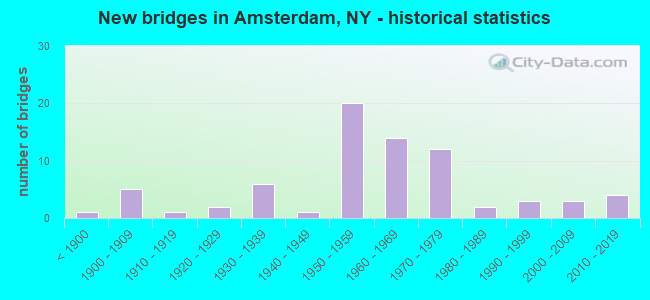
- New bridges - historical statistics
- 1Before 1900
- 51900-1909
- 11910-1919
- 21920-1929
- 61930-1939
- 11940-1949
- 201950-1959
- 141960-1969
- 121970-1979
- 21980-1989
- 31990-1999
- 32000-2009
- 42010-2019
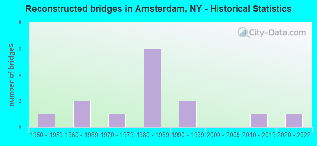
- Reconstructed bridges - Historical Statistics
- 11950-1959
- 21960-1969
- 11970-1979
- 61980-1989
- 21990-1999
- 02000-2009
- 12010-2019
- 12020-2022
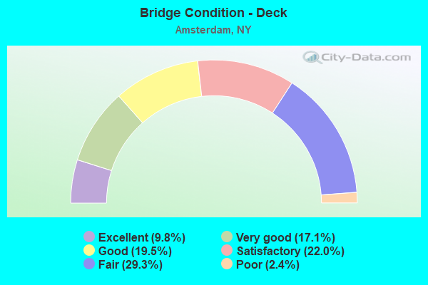
- Bridge Condition - Deck
- 9.8%Excellent
- 17.1%Very good
- 19.5%Good
- 22.0%Satisfactory
- 29.3%Fair
- 2.4%Poor
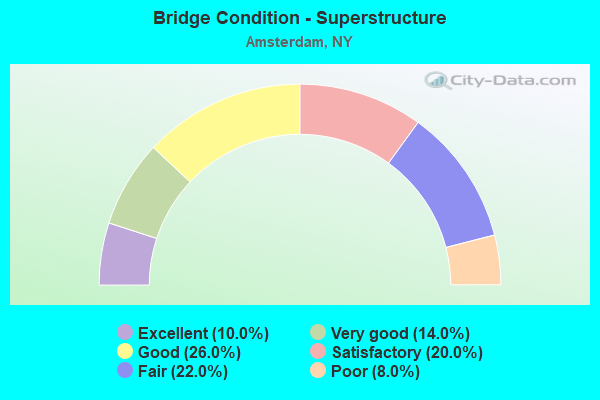
- Bridge Condition - Superstructure
- 10.0%Excellent
- 14.0%Very good
- 26.0%Good
- 20.0%Satisfactory
- 22.0%Fair
- 8.0%Poor
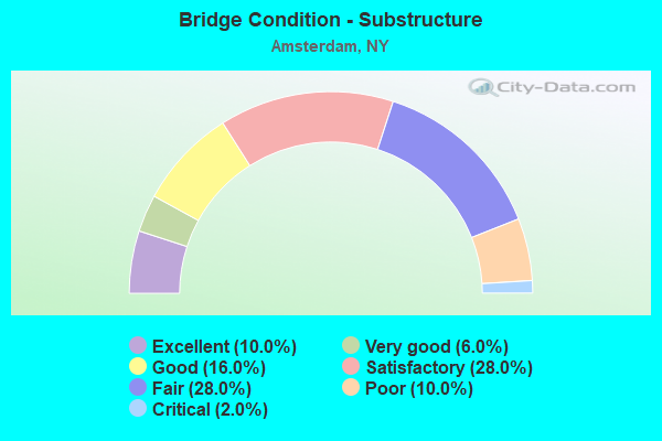
- Bridge Condition - Substructure
- 10.0%Excellent
- 6.0%Very good
- 16.0%Good
- 28.0%Satisfactory
- 28.0%Fair
- 10.0%Poor
- 2.0%Critical
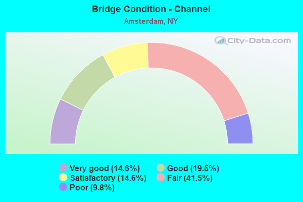
- Bridge Condition - Channel
- 14.6%Very good
- 19.5%Good
- 14.6%Satisfactory
- 41.5%Fair
- 9.8%Poor
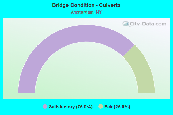
- Bridge Condition - Culverts
- 75.0%Satisfactory
- 25.0%Fair
Find on map >> Show street view
Structure Number: 33102, Location: .5 MILE SE OF MINAVILLE (Lat: 42.878281, Lng: -74.211419), Route carried "on" structure: Other road , Year Built: 1936, Status: Posted for load, Structure Length: 1.74m (5.71ft), Average Daily Traffic: 16 (year 2019), Truck Traffic: 4%, Average Future Daily Traffic: 22 (year 2039), Features Intersected: S CHUCTANUNDA CK, Facility Carried by Structure: CEMETERY DRIVE
Minimum Vertical Clearance: 30+ m (98+ ft), Kilometerpoint: 0.628, Lanes on structure: 1, Owner: County Highway Agency, Approaching Roadway Width: 3.7m (12.1ft), Material/Design: Steel, Design/Construction: Stringer/Multi-beam, Number Of Spans In Main Unit: 1, Length of Maximum Span: 16.7m (54.8ft), Curb-To-Curb Width: 5.0m (16.4ft), Out-to-Out Width: 6.1m (20.0ft)
Condition: Deck: Poor, Superstructure: Satisfactory, Substructure: Fair, Channel: Poor, Operating Rating: 10.4 metric tons, Method Used To Determine Operating Rating: Load and Resistance Factor Rating (LRFR) rating reported by rating factor(RF) method using HL-93 loadings, Inventory Rating: 8.1 metric tons, Method Used To Determine Inventory Rating: Load and Resistance Factor Rating (LRFR) rating reported by rating factor(RF) method using HL-93 loadings, Structural Evaluation: High priority of corrective action, Deck Geometry: High priority of corrective action, Waterway Adequacy: High priority of corrective action, Approach Roadway Alignment: Meets minimum limits, Bridge Posting: Required (Relationship of Operating Rating to Maximum Legal Load: > 39.9% below), Length Of Structure Improvement: 1.73m (5.68ft), Designated Inspection Frequency: Every 12 months, Inspection Date: June 2021, Bridge Improvement Cost: $263,000, Roadway Improvement Cost: $154,000, Total Project Cost: $418,000 ( Estimate for 2021), Deck Structure Type: Concrete Cast-file-Place, Wearing Surface/Protective System: Wearing Surface: Bituminous
Find on map >> Show street view
Structure Number: 331022, Location: 2.5 MI SE OF AMSTERDAM (Lat: 42.915631, Lng: -74.153347), Route carried "on" structure: County highway , Year Built: 1929, Status: Open, Structure Length: 2.13m (6.99ft), Average Daily Traffic: 215 (year 2019), Truck Traffic: 9%, Average Future Daily Traffic: 301 (year 2039), Features Intersected: TERWILLEGER CREEK, Facility Carried by Structure: CR152 PATTERSONVIL
Minimum Vertical Clearance: 30+ m (98+ ft), Kilometerpoint: 0.113, Lanes on structure: 2, Owner: County Highway Agency, Approaching Roadway Width: 6.1m (20.0ft), Skew: 3 degrees, Material/Design: Concrete, Design/Construction: Arch - Deck, Number Of Spans In Main Unit: 1, Length of Maximum Span: 20.7m (67.9ft), Curb-To-Curb Width: 7.5m (24.6ft), Out-to-Out Width: 8.6m (28.2ft)
Condition: Superstructure: Satisfactory, Substructure: Satisfactory, Channel: Fair, Operating Rating: 44.7 metric tons, Method Used To Determine Operating Rating: Field evaluation and documented engineering judgment, Inventory Rating: 17.4 metric tons, Method Used To Determine Inventory Rating: Field evaluation and documented engineering judgment, Structural Evaluation: Somewhat better than minimum adequacy, Deck Geometry: Somewhat better than minimum adequacy, Waterway Adequacy: Meets minimum limits, Approach Roadway Alignment: Meets minimum limits, Length Of Structure Improvement: 2.13m (6.99ft), Designated Inspection Frequency: Every 24 months, Inspection Date: March 2021, Bridge Improvement Cost: $856,000, Roadway Improvement Cost: $501,000, Total Project Cost: $1,358,000 ( Estimate for 2021), Wearing Surface/Protective System: Wearing Surface: Bituminous
Find on map >> Show street view
Structure Number: 331025, Location: 0.4 MILE N OF CRANESVILLE (Lat: 42.922744, Lng: -74.131806), Route carried "on" structure: County highway , Year Built: 2007, Status: Open, Structure Length: 1.49m (4.89ft), Average Daily Traffic: 244 (year 2020), Truck Traffic: 4%, Average Future Daily Traffic: 254 (year 2040), Design Load: HS 25 or greater, Features Intersected: EVAS KILL, Facility Carried by Structure: CR2 CRANES HOLLOW
Minimum Vertical Clearance: 30+ m (98+ ft), Kilometerpoint: 0.692, Lanes on structure: 2, Owner: County Highway Agency, Approaching Roadway Width: 9.1m (29.9ft), Skew: 2 degrees, Material/Design: Prestressed concrete, Design/Construction: Box Beam or Girders - Multiple, Number Of Spans In Main Unit: 1, Length of Maximum Span: 14.0m (45.9ft), Curb-To-Curb Width: 9.2m (30.2ft), Out-to-Out Width: 10.2m (33.5ft)
Condition: Deck: Fair, Superstructure: Very good, Substructure: Very good, Channel: Good, Operating Rating: 75.3 metric tons, Method Used To Determine Operating Rating: Load Factor (LF), Inventory Rating: 44.5 metric tons, Method Used To Determine Inventory Rating: Load Factor (LF), Structural Evaluation: Equal to present desirable criteria, Deck Geometry: Equal to present minimum criteria, Waterway Adequacy: Equal to present minimum criteria, Approach Roadway Alignment: Equal to present desirable criteria, Length Of Structure Improvement: 1.49m (4.89ft), Designated Inspection Frequency: Every 24 months, Inspection Date: June 2021, Bridge Improvement Cost: $336,000, Roadway Improvement Cost: $197,000, Total Project Cost: $533,000 ( Estimate for 2021), Deck Structure Type: Concrete Cast-file-Place, Wearing Surface/Protective System: Wearing Surface: Integral Concrete, Deck Protection: Epoxy Coated Reinforcing
Find on map >> Show street view
Structure Number: 331026, Location: .6 MI N OF CRANESVILLE (Lat: 42.925486, Lng: -74.129931), Route carried "on" structure: County highway , Year Built: 2019, Status: Open, Structure Length: 1.19m (3.90ft), Average Daily Traffic: 244 (year 2020), Truck Traffic: 4%, Average Future Daily Traffic: 254 (year 2040), Design Load: HL 93, Features Intersected: EVAS KILL, Facility Carried by Structure: CR2 CRANES HOLLOW
Minimum Vertical Clearance: 30+ m (98+ ft), Kilometerpoint: 1.046, Lanes on structure: 2, Owner: County Highway Agency, Approaching Roadway Width: 9.1m (29.9ft), Skew: 2 degrees, Material/Design: Concrete, Design/Construction: Frame, Number Of Spans In Main Unit: 1, Length of Maximum Span: 11.3m (37.1ft), Curb-To-Curb Width: 9.1m (29.9ft), Out-to-Out Width: 10.1m (33.1ft)
Condition: Superstructure: Excellent, Substructure: Excellent, Channel: Very good, Operating Rating: 63.5 metric tons, Method Used To Determine Operating Rating: Load Factor (LF), Inventory Rating: 38.1 metric tons, Method Used To Determine Inventory Rating: Load Factor (LF), Structural Evaluation: Superior to present desirable criteria, Deck Geometry: Equal to present minimum criteria, Waterway Adequacy: Meets minimum limits, Approach Roadway Alignment: Equal to present minimum criteria, Length Of Structure Improvement: 1.18m (3.87ft), Designated Inspection Frequency: Every 24 months, Inspection Date: October 2021, Bridge Improvement Cost: $530,000, Roadway Improvement Cost: $310,000, Total Project Cost: $840,000 ( Estimate for 2021)
Find on map >> Show street view
Structure Number: 331027, Location: .7 MI NE OF CRANESVILLE (Lat: 42.927381, Lng: -74.128317), Route carried "on" structure: County highway , Year Built: 1900, Year Reconstructed: 1966, Status: Open, Structure Length: 1.04m (3.41ft), Average Daily Traffic: 244 (year 2020), Truck Traffic: 4%, Average Future Daily Traffic: 254 (year 2040), Features Intersected: EVAS KILL, Facility Carried by Structure: CR2 CRANES HOLLOW
Minimum Vertical Clearance: 30+ m (98+ ft), Kilometerpoint: 1.287, Lanes on structure: 2, Owner: County Highway Agency, Approaching Roadway Width: 5.2m (17.1ft), Skew: 1 degrees, Material/Design: Masonry, Design/Construction: Arch - Deck, Number Of Spans In Main Unit: 1, Length of Maximum Span: 9.4m (30.8ft), Curb-To-Curb Width: 6.9m (22.6ft), Out-to-Out Width: 8.0m (26.2ft)
Condition: Deck: Fair, Superstructure: Fair, Substructure: Fair, Channel: Fair, Operating Rating: 45.4 metric tons, Method Used To Determine Operating Rating: Load Factor (LF), Inventory Rating: 40.8 metric tons, Method Used To Determine Inventory Rating: Load Factor (LF), Structural Evaluation: Somewhat better than minimum adequacy, Deck Geometry: Meets minimum limits, Waterway Adequacy: Meets minimum limits, Approach Roadway Alignment: Meets minimum limits, Length Of Structure Improvement: 1.03m (3.38ft), Designated Inspection Frequency: Every 24 months, Inspection Date: May 2021, Bridge Improvement Cost: $119,000, Roadway Improvement Cost: $70,000, Total Project Cost: $189,000 ( Estimate for 2021)
Find on map >> Show street view
Structure Number: 331028, Location: .9 MI NE OF CRANESVILLE (Lat: 42.928464, Lng: -74.127703), Route carried "on" structure: County highway , Year Built: 1900, Year Reconstructed: 1966, Status: Open, Structure Length: 1.07m (3.51ft), Average Daily Traffic: 147 (year 2017), Truck Traffic: 8%, Average Future Daily Traffic: 206 (year 2037), Features Intersected: EVAS KILL, Facility Carried by Structure: CR2 CRANES HOLLOW
Minimum Vertical Clearance: 30+ m (98+ ft), Kilometerpoint: 1.432, Lanes on structure: 2, Owner: County Highway Agency, Approaching Roadway Width: 4.6m (15.1ft), Material/Design: Masonry, Design/Construction: Arch - Deck, Number Of Spans In Main Unit: 1, Length of Maximum Span: 9.7m (31.8ft), Curb-To-Curb Width: 6.2m (20.3ft), Out-to-Out Width: 7.3m (24.0ft)
Condition: Deck: Fair, Superstructure: Fair, Substructure: Poor, Channel: Fair, Operating Rating: 46.5 metric tons, Method Used To Determine Operating Rating: Field evaluation and documented engineering judgment, Inventory Rating: 20.9 metric tons, Method Used To Determine Inventory Rating: Field evaluation and documented engineering judgment, Structural Evaluation: Meets minimum limits, Deck Geometry: Meets minimum limits, Waterway Adequacy: Meets minimum limits, Approach Roadway Alignment: Meets minimum limits, Length Of Structure Improvement: 1.06m (3.48ft), Designated Inspection Frequency: Every 24 months, Inspection Date: May 2021, Bridge Improvement Cost: $111,000, Roadway Improvement Cost: $65,000, Total Project Cost: $177,000 ( Estimate for 2021)
Find on map >> Show street view
Structure Number: 4425059, Location: 0.2 MI S JCT RTS 5 & 30 (Lat: 42.934928, Lng: -74.193067), Route carried "on" structure: State highway 30, Year Built: 1973, Status: Open, Structure Length: 28.99m (95.11ft), Average Daily Traffic: 16,058 (year 2017), Truck Traffic: 9%, Average Future Daily Traffic: 16,133 (year 2040), Design Load: HS 20, Features Intersected: E.W.ARTERIAL, MOHAWK RIV
Minimum Vertical Clearance: 4.97m (16.31ft), Kilometerpoint: 12.502, Lanes on structure: 5, Lanes under structure: 3, Base Highway Network: Yes, Owner: State Highway Agency, Approaching Roadway Width: 23.2m (76.1ft), Skew: 31 degrees, Navigation Control: Yes ( Vertical Clearance: 10.9m (35.8ft), Horizontal Clearance: 60.9m (199.8ft)), Material/Design: Steel continuous, Design/Construction: Stringer/Multi-beam, Number Of Spans In Main Unit: 6, Length of Maximum Span: 76.2m (250.0ft), Curb or Sidewalk Widths: Left: 1.8m (5.9ft), Right: 0.0m, Curb-To-Curb Width: 23.2m (76.1ft), Out-to-Out Width: 26.1m (85.6ft)
Condition: Deck: Satisfactory, Superstructure: Satisfactory, Substructure: Good, Channel: Very good, Operating Rating: 92.5 metric tons, Method Used To Determine Operating Rating: Field evaluation and documented engineering judgment, Inventory Rating: 32.7 metric tons, Method Used To Determine Inventory Rating: Field evaluation and documented engineering judgment, Structural Evaluation: Equal to present minimum criteria, Deck Geometry: Better than present minimum criteria, Underclear: High priority of corrective action, Waterway Adequacy: Equal to present minimum criteria, Approach Roadway Alignment: Equal to present desirable criteria, Length Of Structure Improvement: 28.98m (95.08ft), Designated Inspection Frequency: Every 24 months, Underwater Inspection Frequency: Every 60 months, Inspection Date: October 2021, Underwater Inspection Date: June 2021, Bridge Improvement Cost: $11,807,000, Roadway Improvement Cost: $6,914,000, Total Project Cost: $18,721,000 ( Estimate for 2021), Deck Structure Type: Concrete Cast-file-Place, Wearing Surface/Protective System: Wearing Surface: Latex Concrete
Find on map >> Show street view
Structure Number: 442505A, Location: 02MI S JCT RTS 5+30 (Lat: 42.935742, Lng: -74.192492), Route carried "on" structure: Ramp State highway 30, Year Built: 1973, Status: Open, Structure Length: 11.58m (37.99ft), Average Daily Traffic: 16,058 (year 2017), Truck Traffic: 9%, Average Future Daily Traffic: 16,133 (year 2040), Design Load: HS 20, Features Intersected: NYS ROUTE 5 EAST BOUND,
Minimum Vertical Clearance: 30+ m (98+ ft), Kilometerpoint: 12.727, Lanes on structure: 2, Lanes under structure: 5, Owner: State Highway Agency, Approaching Roadway Width: 9.8m (32.2ft), Material/Design: Steel continuous, Design/Construction: Stringer/Multi-beam, Number Of Spans In Main Unit: 4, Length of Maximum Span: 35.4m (116.1ft), Curb or Sidewalk Widths: Left: 1.8m (5.9ft), Right: 0.0m, Curb-To-Curb Width: 9.8m (32.2ft), Out-to-Out Width: 10.7m (35.1ft)
Condition: Deck: Excellent, Superstructure: Good, Substructure: Satisfactory, Channel: Good, Operating Rating: 90.0 metric tons, Method Used To Determine Operating Rating: Field evaluation and documented engineering judgment, Inventory Rating: 32.7 metric tons, Method Used To Determine Inventory Rating: Field evaluation and documented engineering judgment, Structural Evaluation: Equal to present minimum criteria, Deck Geometry: Equal to present minimum criteria, Underclear: High priority of corrective action, Waterway Adequacy: Equal to present minimum criteria, Approach Roadway Alignment: Equal to present desirable criteria, Length Of Structure Improvement: 11.58m (37.99ft), Designated Inspection Frequency: Every 24 months, Inspection Date: October 2021, Bridge Improvement Cost: $1,900,000, Roadway Improvement Cost: $1,113,000, Total Project Cost: $3,012,000 ( Estimate for 2021), Deck Structure Type: Concrete Cast-file-Place, Wearing Surface/Protective System: Wearing Surface: Monolithic Concrete
Find on map >> Show street view
Structure Number: 442505B, Location: 02MI S JCT RTS 5+30 (Lat: 42.935517, Lng: -74.192142), Route carried "on" structure: Ramp State highway 30, Year Built: 1973, Status: Open, Structure Length: 6.80m (22.31ft), Average Daily Traffic: 892 (year 2017), Truck Traffic: 8%, Average Future Daily Traffic: 896 (year 2040), Design Load: HS 20, Features Intersected: E W ARTERIAL
Minimum Vertical Clearance: 30+ m (98+ ft), Kilometerpoint: 0.032, Lanes on structure: 1, Lanes under structure: 2, Owner: State Highway Agency, Approaching Roadway Width: 7.9m (25.9ft), Material/Design: Steel continuous, Design/Construction: Stringer/Multi-beam, Number Of Spans In Main Unit: 2, Length of Maximum Span: 34.7m (113.8ft), Curb-To-Curb Width: 7.9m (25.9ft), Out-to-Out Width: 8.8m (28.9ft)
Condition: Deck: Excellent, Superstructure: Very good, Substructure: Good, Operating Rating: 95.8 metric tons, Method Used To Determine Operating Rating: Field evaluation and documented engineering judgment, Inventory Rating: 32.7 metric tons, Method Used To Determine Inventory Rating: Field evaluation and documented engineering judgment, Structural Evaluation: Better than present minimum criteria, Deck Geometry: Equal to present desirable criteria, Underclear: High priority of corrective action, Approach Roadway Alignment: Equal to present desirable criteria, Length Of Structure Improvement: 6.79m (22.28ft), Designated Inspection Frequency: Every 24 months, Inspection Date: October 2021, Bridge Improvement Cost: $950,000, Roadway Improvement Cost: $556,000, Total Project Cost: $1,506,000 ( Estimate for 2021), Deck Structure Type: Concrete Cast-file-Place, Wearing Surface/Protective System: Wearing Surface: Monolithic Concrete
Find on map >> Show street view
Structure Number: 5038799, Location: 04MI S JCT RTS 5S+160 (Lat: 42.918672, Lng: -74.177086), Route carried "on" structure: Interstate 90, Year Built: 1953, Year Reconstructed: 1980, Status: Open, Structure Length: 4.24m (13.91ft), Average Daily Traffic: 23,978 (year 2020), Truck Traffic: 28%, Average Future Daily Traffic: 26,670 (year 2040), Design Load: HS 20, Features Intersected: THAYER RD RTE 16
Minimum Vertical Clearance: 30+ m (98+ ft), Kilometerpoint: 54.384, Lanes on structure: 4, Lanes under structure: 2, Base Highway Network: Yes, Toll: On toll road, Owner: State Toll Authority, Approaching Roadway Width: 33.8m (110.9ft), Skew: 23 degrees, Material/Design: Steel, Design/Construction: Stringer/Multi-beam, Number Of Spans In Main Unit: 3, Length of Maximum Span: 17.1m (56.1ft), Curb-To-Curb Width: 33.5m (109.9ft), Out-to-Out Width: 34.4m (112.9ft)
Condition: Deck: Good, Superstructure: Good, Substructure: Good, Operating Rating: 25.4 metric tons, Method Used To Determine Operating Rating: Load Factor (LF), Inventory Rating: 10.9 metric tons, Method Used To Determine Inventory Rating: Load Factor (LF), Structural Evaluation: High priority of corrective action, Deck Geometry: Superior to present desirable criteria, Underclear: Meets minimum limits, Approach Roadway Alignment: Equal to present desirable criteria, Length Of Structure Improvement: 4.23m (13.88ft), Designated Inspection Frequency: Every 24 months, Inspection Date: September 2021, Bridge Improvement Cost: $2,946,000, Roadway Improvement Cost: $1,725,000, Total Project Cost: $4,671,000 ( Estimate for 2021), Deck Structure Type: Concrete Cast-file-Place, Wearing Surface/Protective System: Wearing Surface: Bituminous, Membrane: Other
Find on map >> Show street view
Structure Number: 551578, Location: 1.5MI SE OF CRANESVILLE (Lat: 42.902542, Lng: -74.125892), Route carried "on" structure: County highway , Year Built: 1952, Year Reconstructed: 1992, Status: Open, Structure Length: 6.40m (21.00ft), Average Daily Traffic: 61 (year 2018), Truck Traffic: 2%, Average Future Daily Traffic: 85 (year 2038), Design Load: HS 20, Features Intersected: 90IX EB, RTE I90, Facility Carried by Structure: BULLS HEAD ROAD
Minimum Vertical Clearance: 30+ m (98+ ft), Kilometerpoint: 8.689, Lanes on structure: 2, Lanes under structure: 4, Owner: State Toll Authority, Approaching Roadway Width: 6.1m (20.0ft), Skew: 1 degrees, Material/Design: Steel, Design/Construction: Stringer/Multi-beam, Number Of Spans In Main Unit: 4, Length of Maximum Span: 18.3m (60.0ft), Curb-To-Curb Width: 8.8m (28.9ft), Out-to-Out Width: 9.4m (30.8ft)
Condition: Deck: Very good, Superstructure: Good, Substructure: Good, Operating Rating: 58.1 metric tons, Method Used To Determine Operating Rating: Load Factor (LF), Inventory Rating: 32.7 metric tons, Method Used To Determine Inventory Rating: Load Factor (LF), Structural Evaluation: Better than present minimum criteria, Deck Geometry: Better than present minimum criteria, Underclear: High priority of corrective action, Approach Roadway Alignment: Equal to present desirable criteria, Length Of Structure Improvement: 6.40m (21.00ft), Designated Inspection Frequency: Every 24 months, Inspection Date: June 2021, Bridge Improvement Cost: $974,000, Roadway Improvement Cost: $570,000, Total Project Cost: $1,544,000 ( Estimate for 2021), Deck Structure Type: Concrete Cast-file-Place, Wearing Surface/Protective System: Wearing Surface: Integral Concrete, Deck Protection: Epoxy Coated Reinforcing
Find on map >> Show street view
Structure Number: 551579, Location: 0.8MI SW OF CRAHESVILLE (Lat: 42.910939, Lng: -74.145733), Route carried "on" structure: County highway , Year Built: 1953, Year Reconstructed: 1991, Status: Open, Structure Length: 8.78m (28.81ft), Average Daily Traffic: 215 (year 2019), Truck Traffic: 9%, Average Future Daily Traffic: 301 (year 2039), Design Load: HS 20+Mod, Features Intersected: 90IX EB, RTE I90, Facility Carried by Structure: PATTERSONVILLE RD
Minimum Vertical Clearance: 30+ m (98+ ft), Kilometerpoint: 0.885, Lanes on structure: 2, Lanes under structure: 4, Owner: State Toll Authority, Approaching Roadway Width: 6.7m (22.0ft), Skew: 4 degrees, Material/Design: Steel, Design/Construction: Stringer/Multi-beam, Number Of Spans In Main Unit: 4, Length of Maximum Span: 25.0m (82.0ft), Curb-To-Curb Width: 9.4m (30.8ft), Out-to-Out Width: 10.1m (33.1ft)
Condition: Deck: Very good, Superstructure: Satisfactory, Substructure: Good, Operating Rating: 58.1 metric tons, Method Used To Determine Operating Rating: Load Factor (LF), Inventory Rating: 32.7 metric tons, Method Used To Determine Inventory Rating: Load Factor (LF), Structural Evaluation: Equal to present minimum criteria, Deck Geometry: Equal to present minimum criteria, Underclear: High priority of corrective action, Approach Roadway Alignment: Equal to present desirable criteria, Length Of Structure Improvement: 8.77m (28.77ft), Designated Inspection Frequency: Every 24 months, Inspection Date: June 2021, Bridge Improvement Cost: $1,396,000, Roadway Improvement Cost: $817,000, Total Project Cost: $2,213,000 ( Estimate for 2021), Deck Structure Type: Concrete Cast-file-Place, Wearing Surface/Protective System: Wearing Surface: Bituminous, Membrane: Other, Deck Protection: Epoxy Coated Reinforcing
Find on map >> Show street view
Structure Number: 55158, Location: 1.3 MI W OF CRANESVILLE (Lat: 42.913031, Lng: -74.153758), Route carried "on" structure: Interstate 90, Year Built: 1952, Year Reconstructed: 1999, Status: Open, Structure Length: 1.52m (4.99ft), Average Daily Traffic: 23,978 (year 2020), Truck Traffic: 28%, Average Future Daily Traffic: 26,670 (year 2040), Design Load: HS 20+Mod, Features Intersected: TERWILLEGER CREEK
Minimum Vertical Clearance: 30+ m (98+ ft), Kilometerpoint: 56.395, Lanes on structure: 4, Base Highway Network: Yes, Toll: On Interstate toll segment, Owner: State Toll Authority, Approaching Roadway Width: 35.1m (115.2ft), Skew: 30 degrees, Material/Design: Concrete, Design/Construction: Arch - Deck, Number Of Spans In Main Unit: 1, Length of Maximum Span: 14.9m (48.9ft), Curb-To-Curb Width: 34.9m (114.5ft), Out-to-Out Width: 115.5m (378.9ft)
Condition: Superstructure: Very good, Substructure: Good, Channel: Fair, Operating Rating: 83.2 metric tons, Method Used To Determine Operating Rating: Field evaluation and documented engineering judgment, Inventory Rating: 32.7 metric tons, Method Used To Determine Inventory Rating: Field evaluation and documented engineering judgment, Structural Evaluation: Better than present minimum criteria, Deck Geometry: Superior to present desirable criteria, Waterway Adequacy: Meets minimum limits, Approach Roadway Alignment: Equal to present desirable criteria, Length Of Structure Improvement: 1.52m (4.99ft), Designated Inspection Frequency: Every 24 months, Inspection Date: June 2020, Bridge Improvement Cost: $4,132,000, Roadway Improvement Cost: $2,419,000, Total Project Cost: $6,551,000 ( Estimate for 2021), Wearing Surface/Protective System: Wearing Surface: Bituminous
Find on map >> Show street view
Structure Number: 551581, Location: 1.4 MI W OF CRANESVILLE (Lat: 42.913239, Lng: -74.154544), Route carried "on" structure: Interstate 90, Year Built: 1953, Year Reconstructed: 2003, Status: Open, Structure Length: 1.04m (3.41ft), Average Daily Traffic: 23,978 (year 2020), Truck Traffic: 28%, Average Future Daily Traffic: 26,670 (year 2040), Design Load: HS 20+Mod, Features Intersected: LANGLEY RD-CR 149
Minimum Vertical Clearance: 30+ m (98+ ft), Kilometerpoint: 56.331, Lanes on structure: 4, Lanes under structure: 2, Base Highway Network: Yes, Toll: On Interstate toll segment, Owner: State Toll Authority, Approaching Roadway Width: 23.8m (78.1ft), Skew: 30 degrees, Material/Design: Concrete, Design/Construction: Frame, Number Of Spans In Main Unit: 1, Length of Maximum Span: 9.1m (29.9ft), Curb-To-Curb Width: 34.6m (113.5ft), Out-to-Out Width: 39.1m (128.3ft)
Condition: Superstructure: Satisfactory, Substructure: Satisfactory, Operating Rating: 79.1 metric tons, Method Used To Determine Operating Rating: Field evaluation and documented engineering judgment, Inventory Rating: 32.7 metric tons, Method Used To Determine Inventory Rating: Field evaluation and documented engineering judgment, Structural Evaluation: Equal to present minimum criteria, Deck Geometry: Superior to present desirable criteria, Underclear: High priority of corrective action, Approach Roadway Alignment: Equal to present desirable criteria, Length Of Structure Improvement: 1.03m (3.38ft), Designated Inspection Frequency: Every 24 months, Inspection Date: June 2020, Bridge Improvement Cost: $2,236,000, Roadway Improvement Cost: $1,309,000, Total Project Cost: $3,545,000 ( Estimate for 2021), Wearing Surface/Protective System: Wearing Surface: Bituminous
Find on map >> Show street view
Structure Number: 551582, Location: AT S END OF AMSTERDAM (Lat: 42.922850, Lng: -74.196489), Route carried "on" structure: Ramp Other road , Year Built: 2014, Status: Open, Structure Length: 5.33m (17.49ft), Average Daily Traffic: 3,377 (year 2018), Truck Traffic: 28%, Average Future Daily Traffic: 3,890 (year 2040), Design Load: HS 25 or greater, Features Intersected: 90IX EB, RTE I90, Facility Carried by Structure: AMSTERDAM INTERCH
Minimum Vertical Clearance: 30+ m (98+ ft), Kilometerpoint: 0.322, Lanes on structure: 2, Lanes under structure: 5, Toll: On toll road, Owner: State Toll Authority, Approaching Roadway Width: 15.2m (49.9ft), Skew: 20 degrees, Material/Design: Steel continuous, Design/Construction: Stringer/Multi-beam, Number Of Spans In Main Unit: 2, Length of Maximum Span: 27.7m (90.9ft), Curb-To-Curb Width: 15.2m (49.9ft), Out-to-Out Width: 16.2m (53.1ft)
Condition: Deck: Very good, Superstructure: Excellent, Substructure: Excellent, Operating Rating: 56.4 metric tons, Method Used To Determine Operating Rating: Load and Resistance Factor Rating (LRFR) rating reported by rating factor(RF) method using HL-93 loadings, Inventory Rating: 42.8 metric tons, Method Used To Determine Inventory Rating: Load and Resistance Factor Rating (LRFR) rating reported by rating factor(RF) method using HL-93 loadings, Structural Evaluation: Superior to present desirable criteria, Deck Geometry: Superior to present desirable criteria, Underclear: Equal to present minimum criteria, Approach Roadway Alignment: Equal to present desirable criteria, Length Of Structure Improvement: 5.33m (17.49ft), Designated Inspection Frequency: Every 24 months, Inspection Date: August 2020, Bridge Improvement Cost: $1,750,000, Roadway Improvement Cost: $1,025,000, Total Project Cost: $2,775,000 ( Estimate for 2021), Deck Structure Type: Concrete Cast-file-Place, Wearing Surface/Protective System: Wearing Surface: Integral Concrete
Find on map >> Show street view
Structure Number: 551583, Location: 1 MI W I-90 EXIT 27 (Lat: 42.927403, Lng: -74.217692), Route carried "on" structure: Interstate 90, Year Built: 1952, Status: Open, Structure Length: 1.68m (5.51ft), Average Daily Traffic: 19,863 (year 2020), Truck Traffic: 31%, Average Future Daily Traffic: 22,093 (year 2040), Design Load: HS 25 or greater, Features Intersected: S CHUCTANUNDA CRK
Minimum Vertical Clearance: 30+ m (98+ ft), Kilometerpoint: 50.941, Lanes on structure: 4, Base Highway Network: Yes, Toll: On Interstate toll segment, Owner: State Toll Authority, Approaching Roadway Width: 24.4m (80.1ft), Skew: 31 degrees, Material/Design: Concrete, Design/Construction: Culvert, Number Of Spans In Main Unit: 2, Length of Maximum Span: 7.3m (24.0ft)
Condition: Channel: Poor, Culverts: Satisfactory, Operating Rating: 77.2 metric tons, Method Used To Determine Operating Rating: Field evaluation and documented engineering judgment, Inventory Rating: 36.7 metric tons, Method Used To Determine Inventory Rating: Field evaluation and documented engineering judgment, Structural Evaluation: Equal to present minimum criteria, Waterway Adequacy: Meets minimum limits, Approach Roadway Alignment: Equal to present desirable criteria, Length Of Structure Improvement: 1.67m (5.48ft), Designated Inspection Frequency: Every 24 months, Inspection Date: June 2020, Bridge Improvement Cost: $1,519,000, Roadway Improvement Cost: $889,000, Total Project Cost: $2,408,000 ( Estimate for 2021)
Find on map >> Show street view
Structure Number: 551584, Location: 1.3 MI W I-90 INT 27 (Lat: 42.929114, Lng: -74.225653), Route carried "on" structure: County highway , Year Built: 1953, Status: Open, Structure Length: 7.53m (24.70ft), Average Daily Traffic: 213 (year 2019), Truck Traffic: 4%, Average Future Daily Traffic: 298 (year 2039), Design Load: HS 20+Mod, Features Intersected: 90IX EB, 90IX, Facility Carried by Structure: SNOOKS CORNERS RD
Minimum Vertical Clearance: 30+ m (98+ ft), Kilometerpoint: 3.492, Lanes on structure: 2, Lanes under structure: 4, Owner: State Toll Authority, Approaching Roadway Width: 6.7m (22.0ft), Skew: 3 degrees, Material/Design: Steel, Design/Construction: Stringer/Multi-beam, Number Of Spans In Main Unit: 4, Length of Maximum Span: 22.3m (73.2ft), Curb or Sidewalk Widths: Left: 0.7m (2.3ft), Right: 0.7m (2.3ft), Curb-To-Curb Width: 7.9m (25.9ft), Out-to-Out Width: 10.1m (33.1ft)
Condition: Deck: Satisfactory, Superstructure: Fair, Substructure: Fair, Operating Rating: 73.5 metric tons, Method Used To Determine Operating Rating: Load Factor (LF), Inventory Rating: 43.5 metric tons, Method Used To Determine Inventory Rating: Load Factor (LF), Structural Evaluation: Somewhat better than minimum adequacy, Deck Geometry: Somewhat better than minimum adequacy, Underclear: High priority of corrective action, Approach Roadway Alignment: Equal to present desirable criteria, Length Of Structure Improvement: 7.52m (24.67ft), Designated Inspection Frequency: Every 24 months, Inspection Date: August 2021, Bridge Improvement Cost: $1,200,000, Roadway Improvement Cost: $703,000, Total Project Cost: $1,903,000 ( Estimate for 2021), Deck Structure Type: Concrete Cast-file-Place, Wearing Surface/Protective System: Wearing Surface: Bituminous
Find on map >> Show street view
Structure Number: 100295, Location: 0.9 MI W JCT RTS 5S & 30 (Lat: 42.933975, Lng: -74.214803), Route carried "under" structure: ServiceCity street , Year Built: 1956, Structure Length: 0. m, Average Daily Traffic: 156 (year 2018), Truck Traffic: 7%, Features Intersected: FLORIDA AVENUE, SO CHUCT, Facility Carried by Structure: RTE 5S
Minimum Vertical Clearance: 4.72m (15.49ft), Kilometerpoint: 0.290, Lanes on structure: 2, Lanes under structure: 2, Material/Design: Steel, Design/Construction: Stringer/Multi-beam, Length of Maximum Span: 21.9m (71.9ft)
Find on map >> Show street view
Structure Number: 100296, Location: 1.0 MI W JCT RTS 5S & 160 (Lat: 42.928342, Lng: -74.198450), Route carried "under" structure: State highway 30, Year Built: 1960, Structure Length: 0. m, Average Daily Traffic: 4,400 (year 1977), Features Intersected: 30 2504 2004 Northbound, Facility Carried by Structure: RTE 5S
Minimum Vertical Clearance: 4.45m (14.60ft), Kilometerpoint: 11.730, Lanes on structure: 2, Lanes under structure: 2, Material/Design: Steel, Design/Construction: Stringer/Multi-beam, Length of Maximum Span: 24.1m (79.1ft)
Find on map >> Show street view
Structure Number: 102105, Location: IN SOUTH AMSTERDAM (Lat: 42.923986, Lng: -74.201797), Route carried "under" structure: Interstate 90, Year Built: 1953, Structure Length: 0. m, Average Daily Traffic: 11,700 (year 1975), Features Intersected: 90IX EB, RTE I90, Facility Carried by Structure: RTE 30
Minimum Vertical Clearance: 4.78m (15.68ft), Kilometerpoint: 279.741, Lanes on structure: 2, Lanes under structure: 3, Toll: On Interstate toll segment, Material/Design: Steel, Design/Construction: Stringer/Multi-beam, Length of Maximum Span: 20.4m (66.9ft)
Find on map >> Show street view
Structure Number: 102106, Location: 0.3 MI N JCT RTS 5S & 30 (Lat: 42.930683, Lng: -74.196833), Route carried "under" structure: State highway 30, Year Built: 1960, Structure Length: 0. m, Average Daily Traffic: 18,770 (year 2012), Features Intersected: 30 NB 30 25042006, RTE 3, Facility Carried by Structure: GRIEME AVE
Minimum Vertical Clearance: 4.50m (14.76ft), Kilometerpoint: 11.842, Lanes on structure: 2, Lanes under structure: 2, Material/Design: Steel, Design/Construction: Stringer/Multi-beam, Length of Maximum Span: 24.0m (78.7ft)
Find on map >> Show street view
Structure Number: 1021079, Location: .5 MI N JCT SH 5S & SH 30 (Lat: 42.933056, Lng: -74.195050), Route carried "under" structure: City street , Year Built: 1960, Structure Length: 0. m, Average Daily Traffic: 100 (year 2011), Features Intersected: RECREATION TRAIL, CLEVEL, Facility Carried by Structure: RTE 30
Minimum Vertical Clearance: 5.66m (18.57ft), Kilometerpoint: 0.000, Lanes on structure: 6, Lanes under structure: 2, Material/Design: Steel, Design/Construction: Stringer/Multi-beam, Length of Maximum Span: 14.3m (46.9ft)
Find on map >> Show street view
Structure Number: 102108, Location: .6 MI N JCT SH 5S & SH 3 (Lat: 42.933744, Lng: -74.195317), Route carried "under" structure: City street , Year Built: 1960, Structure Length: 0. m, Average Daily Traffic: 500 (year 2013), Features Intersected: MINAVILLE STREET, Facility Carried by Structure: RTE 30
Minimum Vertical Clearance: 4.72m (15.49ft), Kilometerpoint: 0.000, Lanes on structure: 2, Lanes under structure: 2, Material/Design: Concrete, Design/Construction: Frame, Length of Maximum Span: 12.1m (39.7ft)
Find on map >> Show street view
Structure Number: 105189, Location: JCT OF RTS 67+30 (Lat: 42.940486, Lng: -74.189333), Route carried "under" structure: City street , Year Built: 1969, Structure Length: 0. m, Average Daily Traffic: 10,000 (year 1971), Features Intersected: RTE 67, SCHULER ST, CHUC, Facility Carried by Structure: RTE 30
Minimum Vertical Clearance: 5.33m (17.49ft), Kilometerpoint: 0.000, Lanes on structure: 2, Lanes under structure: 2, Material/Design: Steel, Design/Construction: Stringer/Multi-beam, Length of Maximum Span: 26.8m (87.9ft)
Find on map >> Show street view
Structure Number: 105189, Location: JCT OF RTS 67+30 (Lat: 42.940486, Lng: -74.189333), Route carried "under" structure: State highway 67, Year Built: 1969, Structure Length: 0. m, Average Daily Traffic: 13,000 (year 1970), Features Intersected: RTE 67, SCHULER ST, CHUC, Facility Carried by Structure: RTE 30
Minimum Vertical Clearance: 6.20m (20.34ft), Kilometerpoint: 3.926, Lanes on structure: 2, Lanes under structure: 2, Material/Design: Steel, Design/Construction: Stringer/Multi-beam, Length of Maximum Span: 26.8m (87.9ft)
Find on map >> Show street view
Structure Number: 106885, Location: 0.3 MI NW JCT RT30&MOHK R (Lat: 42.937944, Lng: -74.195194), Route carried "under" structure: City street , Year Built: 1979, Structure Length: 0. m, Features Intersected: PEARL STREET, Facility Carried by Structure: RAMP NY 5 EB TO NY
Minimum Vertical Clearance: 4.41m (14.47ft), Kilometerpoint: 0.000, Lanes on structure: 1, Lanes under structure: 1, Material/Design: Steel, Design/Construction: Stringer/Multi-beam, Length of Maximum Span: 27.1m (88.9ft)
Find on map >> Show street view
Structure Number: 227109, Location: 500 feet East of Route 30 (Lat: 42.934728, Lng: -74.190950), Route carried "under" structure: State highway , Year Built: 1999, Structure Length: 0. m, Features Intersected: Ramp from NY30NB, Front, Facility Carried by Structure: Pedestrian Walkway
Minimum Vertical Clearance: 6.60m (21.65ft), Kilometerpoint: 55.334, Lanes under structure: 1, Material/Design: Steel, Design/Construction: Truss - Thru, Length of Maximum Span: 46.6m (152.9ft)
Find on map >> Show street view
Structure Number: 4425059, Location: 0.2 MI S JCT RTS 5 & 30 (Lat: 42.934928, Lng: -74.193067), Route carried "under" structure: State highway , Year Built: 1973, Structure Length: 0. m, Average Daily Traffic: 3,000 (year 2021), Features Intersected: E.W.ARTERIAL, MOHAWK RIV, Facility Carried by Structure: RTE 30
Minimum Vertical Clearance: 5.53m (18.14ft), Kilometerpoint: 54.642, Lanes on structure: 5, Lanes under structure: 3, Material/Design: Steel continuous, Design/Construction: Stringer/Multi-beam, Length of Maximum Span: 76.2m (250.0ft)
Find on map >> Show street view
Structure Number: 442505A, Location: 02MI S JCT RTS 5+30 (Lat: 42.935742, Lng: -74.192492), Route carried "under" structure: State highway , Year Built: 1973, Structure Length: 0. m, Features Intersected: NYS ROUTE 5 EAST BOUND,, Facility Carried by Structure: RTE 30
Minimum Vertical Clearance: 6.10m (20.01ft), Kilometerpoint: 0.000, Lanes on structure: 2, Lanes under structure: 2, Material/Design: Steel continuous, Design/Construction: Stringer/Multi-beam, Length of Maximum Span: 35.4m (116.1ft)
Find on map >> Show street view
Structure Number: 442505B, Location: 02MI S JCT RTS 5+30 (Lat: 42.935517, Lng: -74.192142), Route carried "under" structure: State highway , Year Built: 1973, Structure Length: 0. m, Average Daily Traffic: 9,050 (year 1984), Features Intersected: E W ARTERIAL, Facility Carried by Structure: RTE 30
Minimum Vertical Clearance: 5.26m (17.26ft), Kilometerpoint: 54.642, Lanes on structure: 1, Lanes under structure: 2, Material/Design: Steel continuous, Design/Construction: Stringer/Multi-beam, Length of Maximum Span: 34.7m (113.8ft)
Find on map >> Show street view
Structure Number: 5038799, Location: 04MI S JCT RTS 5S+160 (Lat: 42.918672, Lng: -74.177086), Route carried "under" structure: County highway , Year Built: 1953, Structure Length: 0. m, Average Daily Traffic: 600 (year 2013), Truck Traffic: 5%, Features Intersected: THAYER RD RTE 16, Facility Carried by Structure: RTE 90I
Minimum Vertical Clearance: 4.75m (15.58ft), Kilometerpoint: 3.701, Lanes on structure: 4, Lanes under structure: 2, Material/Design: Steel, Design/Construction: Stringer/Multi-beam, Length of Maximum Span: 17.1m (56.1ft)
Find on map >> Show street view
Structure Number: 551578, Location: 1.5MI SE OF CRANESVILLE (Lat: 42.902542, Lng: -74.125892), Route carried "under" structure: Interstate 90, Year Built: 1952, Structure Length: 0. m, Average Daily Traffic: 17,300 (year 2021), Features Intersected: 90IX EB, RTE I90, Facility Carried by Structure: BULLS HEAD ROAD
Minimum Vertical Clearance: 4.45m (14.60ft), Kilometerpoint: 273.047, Lanes on structure: 2, Lanes under structure: 2, Toll: On Interstate toll segment, Material/Design: Steel, Design/Construction: Stringer/Multi-beam, Length of Maximum Span: 18.3m (60.0ft)
Find on map >> Show street view
Structure Number: 551579, Location: 0.8MI SW OF CRAHESVILLE (Lat: 42.910939, Lng: -74.145733), Route carried "under" structure: Interstate 90, Year Built: 1953, Structure Length: 0. m, Average Daily Traffic: 23,978 (year 2020), Truck Traffic: 28%, Features Intersected: 90IX EB, RTE I90, Facility Carried by Structure: PATTERSONVILLE RD
Minimum Vertical Clearance: 4.50m (14.76ft), Kilometerpoint: 56.959, Lanes on structure: 2, Lanes under structure: 2, Toll: On Interstate toll segment, Material/Design: Steel, Design/Construction: Stringer/Multi-beam, Length of Maximum Span: 25.0m (82.0ft)
Find on map >> Show street view
Structure Number: 551581, Location: 1.4 MI W OF CRANESVILLE (Lat: 42.913239, Lng: -74.154544), Route carried "under" structure: County highway , Year Built: 1953, Structure Length: 0. m, Average Daily Traffic: 61 (year 2010), Truck Traffic: 8%, Features Intersected: LANGLEY RD-CR 149, Facility Carried by Structure: RTE I90
Minimum Vertical Clearance: 4.45m (14.60ft), Kilometerpoint: 7.241, Lanes on structure: 4, Lanes under structure: 2, Material/Design: Concrete, Design/Construction: Frame, Length of Maximum Span: 9.1m (29.9ft)
Find on map >> Show street view
Structure Number: 551582, Location: AT S END OF AMSTERDAM (Lat: 42.922850, Lng: -74.196489), Route carried "under" structure: Interstate 90, Year Built: 2014, Structure Length: 0. m, Average Daily Traffic: 27,695 (year 2014), Features Intersected: 90IX EB, RTE I90, Facility Carried by Structure: AMSTERDAM INTERCH
Minimum Vertical Clearance: 5.26m (17.26ft), Kilometerpoint: 279.306, Lanes on structure: 2, Lanes under structure: 2, Toll: On Interstate toll segment, Material/Design: Steel continuous, Design/Construction: Stringer/Multi-beam, Length of Maximum Span: 27.7m (90.9ft)
Find on map >> Show street view
Structure Number: 551584, Location: 1.3 MI W I-90 INT 27 (Lat: 42.929114, Lng: -74.225653), Route carried "under" structure: Interstate , Year Built: 1953, Structure Length: 0. m, Average Daily Traffic: 12,024 (year 1977), Features Intersected: 90IX EB, 90IX, Facility Carried by Structure: SNOOKS CORNERS RD
Minimum Vertical Clearance: 4.32m (14.17ft), Kilometerpoint: 281.768, Lanes on structure: 2, Lanes under structure: 2, Toll: On Interstate toll segment, Material/Design: Steel, Design/Construction: Stringer/Multi-beam, Length of Maximum Span: 22.3m (73.2ft)
Find on map >> Show street view
Structure Number: 700256, Location: 10MI E JCT RTS 5+30 (Lat: 42.924128, Lng: -74.165392), Route carried "under" structure: State highway 5, Year Built: 1959, Structure Length: 0. m, Average Daily Traffic: 8,200 (year 1977), Features Intersected: RTE 5, Facility Carried by Structure: CSX TRANSPRTATION
Minimum Vertical Clearance: 4.39m (14.40ft), Kilometerpoint: 0.000, Lanes under structure: 4, Material/Design: Steel, Design/Construction: Girder and Floorbeam System, Length of Maximum Span: 24.9m (81.7ft)