Bridge Statistics for Anaconda-Deer Lodge County, Montana (MT)
Condition, Traffic, Stress, Structural Evaluation, Project Costs
- National Bridge Inventory (NBI) Statistics
- 96Number of bridges
- 679ft / 207mTotal length
- $2,030,000Total costs
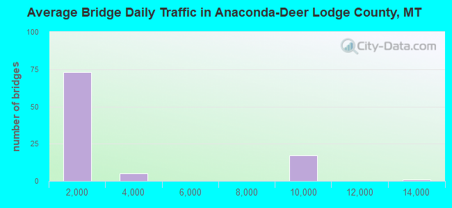
- 193,844Total average daily traffic
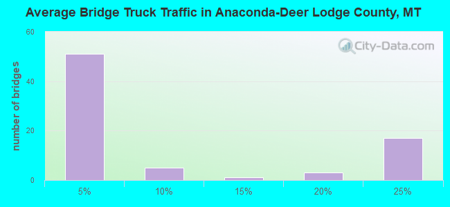
- 35,214Total average daily truck traffic
- National Bridge Inventory (NBI) Registered Bridges for Anaconda-Deer Lodge County
- No street view available for this location
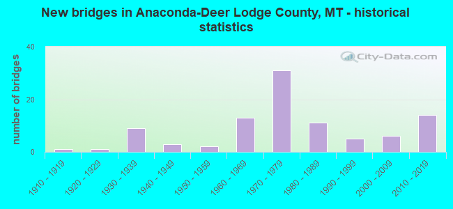
- New bridges - historical statistics
- 11910-1919
- 11920-1929
- 91930-1939
- 31940-1949
- 21950-1959
- 131960-1969
- 311970-1979
- 111980-1989
- 51990-1999
- 62000-2009
- 142010-2019
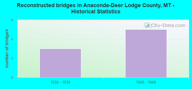
- Reconstructed bridges - Historical Statistics
- 31930-1939
- 51940-1949
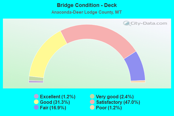
- Bridge Condition - Deck
- 1.2%Excellent
- 2.4%Very good
- 31.3%Good
- 47.0%Satisfactory
- 16.9%Fair
- 1.2%Poor
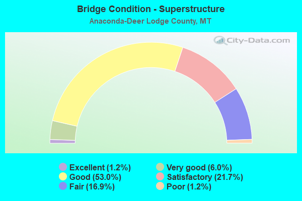
- Bridge Condition - Superstructure
- 1.2%Excellent
- 6.0%Very good
- 53.0%Good
- 21.7%Satisfactory
- 16.9%Fair
- 1.2%Poor
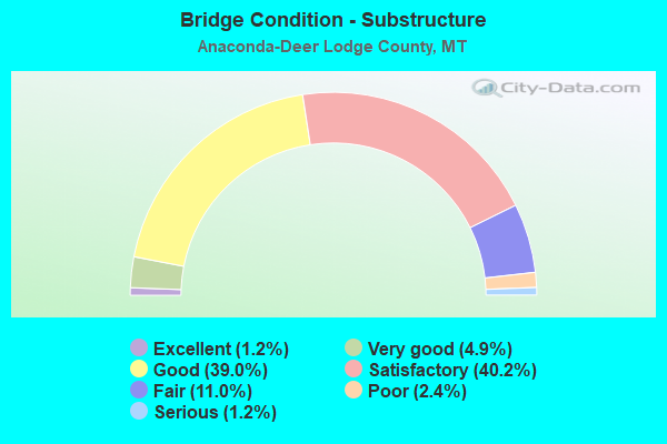
- Bridge Condition - Substructure
- 1.2%Excellent
- 4.9%Very good
- 39.0%Good
- 40.2%Satisfactory
- 11.0%Fair
- 2.4%Poor
- 1.2%Serious
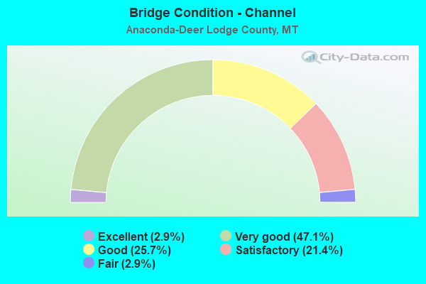
- Bridge Condition - Channel
- 2.9%Excellent
- 47.1%Very good
- 25.7%Good
- 21.4%Satisfactory
- 2.9%Fair
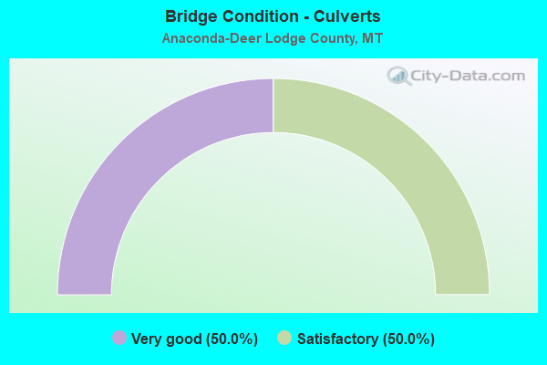
- Bridge Condition - Culverts
- 50.0%Very good
- 50.0%Satisfactory
Find on map >> Show street view
Structure Number: P00046053+00751, Location: 12M NW WISE RIVER (Lat: 45.883325, Lng: -113.143558), Route carried "on" structure: State highway 43, Year Built: 2006, Status: Open, Structure Length: 1.60m (5.25ft), Average Daily Traffic: 314 (year 2020), Truck Traffic: 5%, Average Future Daily Traffic: 341 (year 2040), Design Load: HL 93, Features Intersected: SEYMOUR CREEK
Minimum Vertical Clearance: 30+ m (98+ ft), Kilometerpoint: 85.170, Lanes on structure: 2, Base Highway Network: Yes, Owner: State Highway Agency, Approaching Roadway Width: 10.8m (35.4ft), Material/Design: Prestressed concrete, Design/Construction: Stringer/Multi-beam, Number Of Spans In Main Unit: 1, Length of Maximum Span: 16.0m (52.5ft), Curb-To-Curb Width: 10.8m (35.4ft), Out-to-Out Width: 11.5m (37.7ft)
Condition: Deck: Satisfactory, Superstructure: Good, Substructure: Good, Channel: Very good, Operating Rating: 74.4 metric tons, Method Used To Determine Operating Rating: Load and Resistance Factor (LRFR), Inventory Rating: 53.5 metric tons, Method Used To Determine Inventory Rating: Load and Resistance Factor (LRFR), Structural Evaluation: Better than present minimum criteria, Deck Geometry: Better than present minimum criteria, Waterway Adequacy: Equal to present desirable criteria, Approach Roadway Alignment: Equal to present desirable criteria, Designated Inspection Frequency: Every 24 months, Inspection Date: Febuary 2021, Deck Structure Type: Concrete Cast-file-Place, Wearing Surface/Protective System: Deck Protection: Epoxy Coated Reinforcing
Find on map >> Show street view
Structure Number: P00046054+03551, Location: 10M NW WISE RIVER (Lat: 45.883975, Lng: -113.117317), Route carried "on" structure: State highway 43, Year Built: 2006, Status: Open, Structure Length: 2.70m (8.86ft), Average Daily Traffic: 314 (year 2020), Truck Traffic: 5%, Average Future Daily Traffic: 341 (year 2040), Design Load: HL 93, Features Intersected: DEEP CREEK
Minimum Vertical Clearance: 30+ m (98+ ft), Kilometerpoint: 87.208, Lanes on structure: 2, Base Highway Network: Yes, Owner: State Highway Agency, Approaching Roadway Width: 14.4m (47.2ft), Skew: 2 degrees, Material/Design: Prestressed concrete, Design/Construction: Stringer/Multi-beam, Number Of Spans In Main Unit: 1, Length of Maximum Span: 27.0m (88.6ft), Curb-To-Curb Width: 14.4m (47.2ft), Out-to-Out Width: 15.1m (49.5ft)
Condition: Deck: Satisfactory, Superstructure: Good, Substructure: Satisfactory, Channel: Very good, Operating Rating: 71.7 metric tons, Method Used To Determine Operating Rating: Load and Resistance Factor (LRFR), Inventory Rating: 46.3 metric tons, Method Used To Determine Inventory Rating: Load and Resistance Factor (LRFR), Structural Evaluation: Equal to present minimum criteria, Deck Geometry: Superior to present desirable criteria, Waterway Adequacy: Equal to present desirable criteria, Approach Roadway Alignment: Equal to present desirable criteria, Designated Inspection Frequency: Every 24 months, Inspection Date: Febuary 2021, Deck Structure Type: Concrete Cast-file-Place, Wearing Surface/Protective System: Deck Protection: Epoxy Coated Reinforcing
Find on map >> Show street view
Structure Number: P00047006+07311, Location: WARM SPRINGS (Lat: 46.180531, Lng: -112.785156), Route carried "on" structure: State highway 48, Year Built: 1931, Year Reconstructed: 1949, Status: Open, Structure Length: 0.85m (2.79ft), Average Daily Traffic: 1,604 (year 2020), Truck Traffic: 1%, Average Future Daily Traffic: 1,684 (year 2040), Design Load: H 15, Features Intersected: WARM SPRINGS CREEK
Minimum Vertical Clearance: 30+ m (98+ ft), Kilometerpoint: 10.836, Lanes on structure: 2, Base Highway Network: Yes, Owner: State Highway Agency, Approaching Roadway Width: 11.0m (36.1ft), Material/Design: Concrete, Design/Construction: Tee Beam, Number Of Spans In Main Unit: 1, Length of Maximum Span: 8.2m (26.9ft), Curb-To-Curb Width: 11.0m (36.1ft), Out-to-Out Width: 11.9m (39.0ft)
Condition: Deck: Satisfactory, Superstructure: Satisfactory, Substructure: Fair, Channel: Very good, Operating Rating: 22.7 metric tons, Method Used To Determine Operating Rating: Load Factor (LF), Inventory Rating: 13.6 metric tons, Method Used To Determine Inventory Rating: Load Factor (LF), Structural Evaluation: Meets minimum limits, Deck Geometry: Equal to present minimum criteria, Waterway Adequacy: Equal to present desirable criteria, Approach Roadway Alignment: Equal to present desirable criteria, Designated Inspection Frequency: Every 24 months, Inspection Date: July 2021, Deck Structure Type: Other, Wearing Surface/Protective System: Wearing Surface: Bituminous
Find on map >> Show street view
Structure Number: S00273000+07001, Location: 2M NE ANACONDA (Lat: 46.137642, Lng: -112.891711), Route carried "on" structure: State highway 273, Year Built: 1988, Status: Open, Structure Length: 2.13m (6.99ft), Average Daily Traffic: 925 (year 2020), Average Future Daily Traffic: 971 (year 2040), Design Load: HS 20, Features Intersected: WARM SPRINGS CREEK
Minimum Vertical Clearance: 30+ m (98+ ft), Kilometerpoint: 0.879, Lanes on structure: 2, Owner: State Highway Agency, Approaching Roadway Width: 10.4m (34.1ft), Material/Design: Concrete continuous, Design/Construction: Slab, Number Of Spans In Main Unit: 3, Length of Maximum Span: 8.2m (26.9ft), Curb-To-Curb Width: 10.1m (33.1ft), Out-to-Out Width: 11.1m (36.4ft)
Condition: Deck: Satisfactory, Superstructure: Satisfactory, Substructure: Satisfactory, Channel: Very good, Operating Rating: 53.5 metric tons, Method Used To Determine Operating Rating: Load Factor (LF), Inventory Rating: 31.8 metric tons, Method Used To Determine Inventory Rating: Load Factor (LF), Structural Evaluation: Equal to present minimum criteria, Deck Geometry: Equal to present minimum criteria, Waterway Adequacy: Equal to present desirable criteria, Approach Roadway Alignment: Equal to present desirable criteria, Designated Inspection Frequency: Every 24 months, Inspection Date: July 2021, Deck Structure Type: Concrete Cast-file-Place, Wearing Surface/Protective System: Deck Protection: Epoxy Coated Reinforcing
Find on map >> Show street view
Structure Number: I00090191+08641, Location: 5M S DEER LODGE (Lat: 46.317383, Lng: -112.745222), Route carried "under" structure: ServiceState highway 39000, Year Built: 1975, Structure Length: 0. m, Average Daily Traffic: 100 (year 2022), Truck Traffic: 3%, Features Intersected: SEP SAGER LANE, Facility Carried by Structure: I 90
Minimum Vertical Clearance: 4.52m (14.83ft), Kilometerpoint: 0.022, Lanes on structure: 2, Lanes under structure: 2, Material/Design: Concrete continuous, Design/Construction: Slab, Length of Maximum Span: 9.1m (29.9ft)
Find on map >> Show street view
Structure Number: I00090191+08642, Location: 5M S DEER LODGE (Lat: 46.317378, Lng: -112.744881), Route carried "under" structure: ServiceState highway 39000, Year Built: 1975, Structure Length: 0. m, Average Daily Traffic: 100 (year 2022), Truck Traffic: 3%, Features Intersected: SEP SAGER LANE, Facility Carried by Structure: I 90
Minimum Vertical Clearance: 4.90m (16.08ft), Kilometerpoint: 0.048, Lanes on structure: 2, Lanes under structure: 2, Material/Design: Concrete continuous, Design/Construction: Slab, Length of Maximum Span: 9.1m (29.9ft)
Find on map >> Show street view
Structure Number: I00090197+05601, Location: 37M N WARM SPRINGS (Lat: 46.237486, Lng: -112.764975), Route carried "under" structure: State highway 273, Year Built: 1978, Structure Length: 0. m, Average Daily Traffic: 100 (year 2022), Truck Traffic: 3%, Features Intersected: INT GALEN, Facility Carried by Structure: I 90
Minimum Vertical Clearance: 4.97m (16.31ft), Kilometerpoint: 0.000, Lanes on structure: 2, Lanes under structure: 2, Material/Design: Prestressed concrete, Design/Construction: Stringer/Multi-beam, Length of Maximum Span: 18.7m (61.4ft)
Find on map >> Show street view
Structure Number: I00090197+05602, Location: 37M N WARM SPRINGS (Lat: 46.237486, Lng: -112.764625), Route carried "under" structure: State highway 273, Year Built: 1978, Structure Length: 0. m, Average Daily Traffic: 100 (year 2022), Truck Traffic: 3%, Features Intersected: INT GALEN, Facility Carried by Structure: I 90
Minimum Vertical Clearance: 5.33m (17.49ft), Kilometerpoint: 0.026, Lanes on structure: 2, Lanes under structure: 2, Material/Design: Prestressed concrete, Design/Construction: Stringer/Multi-beam, Length of Maximum Span: 18.7m (61.4ft)
Find on map >> Show street view
Structure Number: I00090199+06471, Location: 19M N WARM SPRINGS (Lat: 46.208556, Lng: -112.777306), Route carried "under" structure: ServiceCounty highway 12098, Year Built: 1978, Structure Length: 0. m, Average Daily Traffic: 100 (year 2022), Truck Traffic: 3%, Features Intersected: SEP PERKINS LANE, Facility Carried by Structure: I 90
Minimum Vertical Clearance: 4.11m (13.48ft), Kilometerpoint: 0.021, Lanes on structure: 2, Lanes under structure: 2, Material/Design: Concrete continuous, Design/Construction: Slab, Length of Maximum Span: 9.1m (29.9ft)
Find on map >> Show street view
Structure Number: I00090199+06472, Location: 19M N WARM SPRINGS (Lat: 46.208556, Lng: -112.776928), Route carried "under" structure: ServiceCounty highway 12098, Year Built: 1978, Structure Length: 0. m, Average Daily Traffic: 100 (year 2022), Truck Traffic: 3%, Features Intersected: SEP HUFFMAN LANE, Facility Carried by Structure: I 90
Minimum Vertical Clearance: 4.11m (13.48ft), Kilometerpoint: 0.050, Lanes on structure: 2, Lanes under structure: 2, Material/Design: Concrete continuous, Design/Construction: Slab, Length of Maximum Span: 9.1m (29.9ft)
Find on map >> Show street view
Structure Number: I00090201+05491, Location: WARM SPRINGS (Lat: 46.181567, Lng: -112.783956), Route carried "under" structure: State highway 48, Year Built: 1978, Structure Length: 0. m, Average Daily Traffic: 100 (year 2022), Truck Traffic: 3%, Features Intersected: INT WARM SPRINGS, Facility Carried by Structure: I 90
Minimum Vertical Clearance: 4.91m (16.11ft), Kilometerpoint: 0.000, Lanes on structure: 2, Lanes under structure: 2, Material/Design: Prestressed concrete, Design/Construction: Stringer/Multi-beam, Length of Maximum Span: 21.6m (70.9ft)
Find on map >> Show street view
Structure Number: I00090201+05492, Location: WARM SPRINGS (Lat: 46.181514, Lng: -112.783867), Route carried "under" structure: State highway 48, Year Built: 1978, Structure Length: 0. m, Average Daily Traffic: 100 (year 2022), Truck Traffic: 3%, Features Intersected: INT WARM SPRINGS, Facility Carried by Structure: I 90
Minimum Vertical Clearance: 5.18m (16.99ft), Kilometerpoint: 0.003, Lanes on structure: 2, Lanes under structure: 2, Material/Design: Prestressed concrete, Design/Construction: Stringer/Multi-beam, Length of Maximum Span: 21.6m (70.9ft)
Find on map >> Show street view
Structure Number: L12027000+01001, Location: 5M S WARM SPRINGS (Lat: 46.107383, Lng: -112.796853), Route carried "under" structure: Interstate 90, Year Built: 1964, Structure Length: 0. m, Average Daily Traffic: 8,817 (year 2020), Truck Traffic: 21%, Features Intersected: SEP I 90 003, Facility Carried by Structure: STEWART ST
Minimum Vertical Clearance: 5.28m (17.32ft), Kilometerpoint: 330.480, Lanes on structure: 2, Lanes under structure: 4, Material/Design: Prestressed concrete, Design/Construction: Stringer/Multi-beam, Length of Maximum Span: 17.2m (56.4ft)
Find on map >> Show street view
Structure Number: L39188000+01501, Location: 8M S DEER LODGE (Lat: 46.269950, Lng: -112.748353), Route carried "under" structure: Interstate 90, Year Built: 1978, Structure Length: 0. m, Average Daily Traffic: 8,559 (year 2020), Truck Traffic: 23%, Features Intersected: INT RACETRACK-I 90 001, Facility Carried by Structure: RACE TRACK RD
Minimum Vertical Clearance: 5.43m (17.81ft), Kilometerpoint: 311.789, Lanes on structure: 2, Lanes under structure: 4, Material/Design: Prestressed concrete, Design/Construction: Stringer/Multi-beam, Length of Maximum Span: 27.4m (89.9ft)
Find on map >> Show street view
Structure Number: P00019000+00001, Location: 6M S WARM SPRINGS (Lat: 46.095586, Lng: -112.792939), Route carried "under" structure: Interstate 90, Year Built: 1964, Structure Length: 0. m, Average Daily Traffic: 12,919 (year 2020), Truck Traffic: 14%, Features Intersected: INT I 90, Facility Carried by Structure: S 1
Minimum Vertical Clearance: 5.48m (17.98ft), Kilometerpoint: 331.854, Lanes on structure: 2, Lanes under structure: 4, Material/Design: Prestressed concrete, Design/Construction: Stringer/Multi-beam, Length of Maximum Span: 17.2m (56.4ft)