Bridge Statistics for Andover, Kansas (KS)
Condition, Traffic, Stress, Structural Evaluation, Project Costs
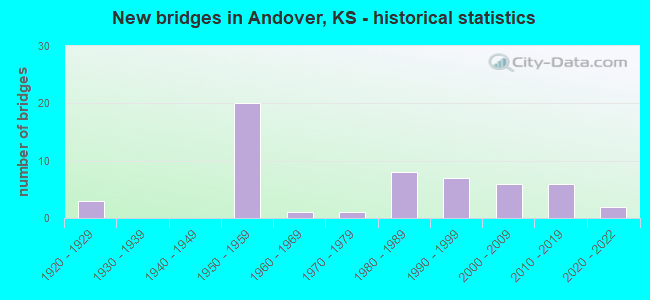
- New bridges - historical statistics
- 31920-1929
- 201950-1959
- 11960-1969
- 11970-1979
- 81980-1989
- 71990-1999
- 62000-2009
- 62010-2019
- 22020-2022
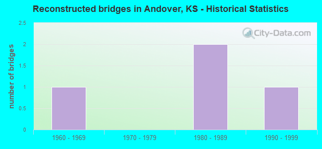
- Reconstructed bridges - Historical Statistics
- 11960-1969
- 01970-1979
- 21980-1989
- 11990-1999
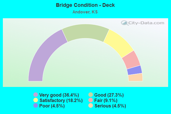
- Bridge Condition - Deck
- 36.4%Very good
- 27.3%Good
- 18.2%Satisfactory
- 9.1%Fair
- 4.5%Poor
- 4.5%Serious
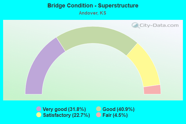
- Bridge Condition - Superstructure
- 31.8%Very good
- 40.9%Good
- 22.7%Satisfactory
- 4.5%Fair
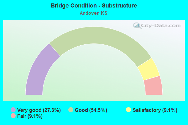
- Bridge Condition - Substructure
- 27.3%Very good
- 54.5%Good
- 9.1%Satisfactory
- 9.1%Fair
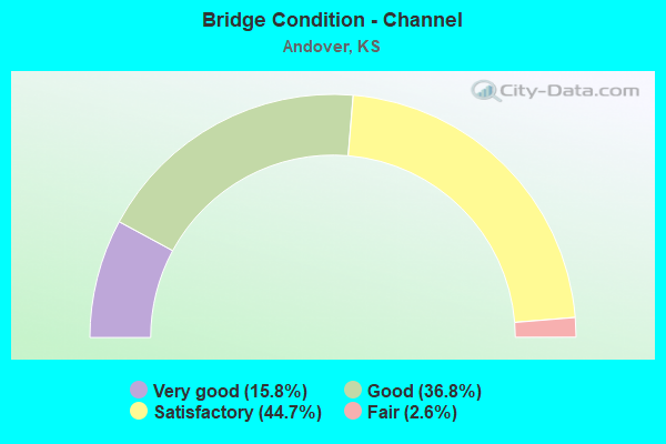
- Bridge Condition - Channel
- 15.8%Very good
- 36.8%Good
- 44.7%Satisfactory
- 2.6%Fair
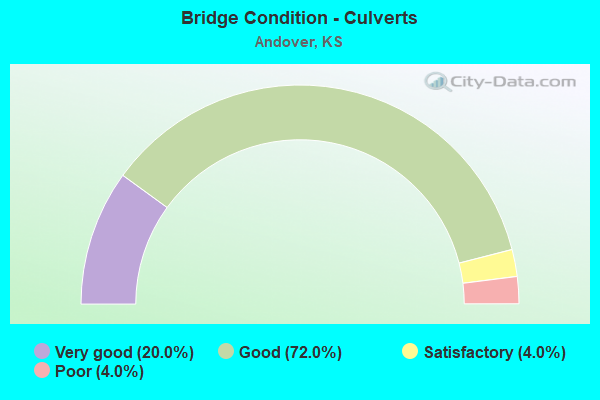
- Bridge Condition - Culverts
- 20.0%Very good
- 72.0%Good
- 4.0%Satisfactory
- 4.0%Poor
Find on map >> Show street view
Structure Number: 80041, Location: 6.4N OF ROSE HILL (Lat: 37.659133, Lng: -97.135469), Route carried "on" structure: City street 6875, Year Built: 2016, Status: Open, Structure Length: 7.22m (23.69ft), Average Daily Traffic: 7,310 (year 2016), Truck Traffic: 2%, Average Future Daily Traffic: 20,355 (year 2041), Design Load: HL 93, Features Intersected: FOUR MILE CREEK, Facility Carried by Structure: RS 71 843-13SB
Minimum Vertical Clearance: 30.47m (99.97ft), Kilometerpoint: 0.000, Lanes on structure: 2, Owner: City or Municipal Highway Agency, Approaching Roadway Width: 8.2m (26.9ft), Material/Design: Prestressed concrete continuous, Design/Construction: Slab, Number Of Spans In Main Unit: 3, Length of Maximum Span: 28.0m (91.9ft), Curb or Sidewalk Widths: Left: 1.5m (4.9ft), Right: 0.0m, Curb-To-Curb Width: 9.1m (29.9ft), Out-to-Out Width: 11.6m (38.1ft)
Condition: Deck: Very good, Superstructure: Very good, Substructure: Very good, Channel: Very good, Operating Rating: 97.1 metric tons, Method Used To Determine Operating Rating: Load and Resistance Factor (LRFR), Inventory Rating: 45.0 metric tons, Method Used To Determine Inventory Rating: Load and Resistance Factor (LRFR), Structural Evaluation: Equal to present desirable criteria, Deck Geometry: Meets minimum limits, Waterway Adequacy: Equal to present desirable criteria, Approach Roadway Alignment: Equal to present desirable criteria, Designated Inspection Frequency: Every 24 months, Inspection Date: December 2021, Deck Structure Type: Concrete Cast-file-Place, Wearing Surface/Protective System: Wearing Surface: Monolithic Concrete, Deck Protection: Epoxy Coated Reinforcing
Find on map >> Show street view
Structure Number: 80042, Location: 6.4N OF ROSE HILL (Lat: 37.659133, Lng: -97.135164), Route carried "on" structure: City street 6875, Year Built: 2016, Status: Open, Structure Length: 7.22m (23.69ft), Average Daily Traffic: 7,310 (year 2016), Truck Traffic: 2%, Average Future Daily Traffic: 20,355 (year 2041), Design Load: HL 93, Features Intersected: FOUR MILE CREEK, Facility Carried by Structure: RS 71 843-13NB
Minimum Vertical Clearance: 30.47m (99.97ft), Kilometerpoint: 0.000, Lanes on structure: 2, Owner: City or Municipal Highway Agency, Approaching Roadway Width: 8.2m (26.9ft), Material/Design: Prestressed concrete continuous, Design/Construction: Slab, Number Of Spans In Main Unit: 3, Length of Maximum Span: 28.0m (91.9ft), Curb or Sidewalk Widths: Left: 0.0m, Right: 3.0m (9.8ft), Curb-To-Curb Width: 9.1m (29.9ft), Out-to-Out Width: 13.1m (43.0ft)
Condition: Deck: Very good, Superstructure: Very good, Substructure: Very good, Channel: Very good, Operating Rating: 97.1 metric tons, Method Used To Determine Operating Rating: Load and Resistance Factor (LRFR), Inventory Rating: 45.0 metric tons, Method Used To Determine Inventory Rating: Load and Resistance Factor (LRFR), Structural Evaluation: Equal to present desirable criteria, Deck Geometry: Meets minimum limits, Waterway Adequacy: Equal to present desirable criteria, Approach Roadway Alignment: Equal to present desirable criteria, Designated Inspection Frequency: Every 24 months, Inspection Date: December 2021, Deck Structure Type: Concrete Cast-file-Place, Wearing Surface/Protective System: Wearing Surface: Monolithic Concrete, Deck Protection: Epoxy Coated Reinforcing
Find on map >> Show street view
Structure Number: 8005, Location: 0.3N OF ANDOVER (Lat: 37.718636, Lng: -97.135122), Route carried "on" structure: City street 72, Year Built: 1994, Status: Open, Structure Length: 1.56m (5.12ft), Average Daily Traffic: 7,456 (year 2012), Truck Traffic: 5%, Average Future Daily Traffic: 7,456 (year 2041), Design Load: HS 20, Features Intersected: REPUBLICAN CREEK
Minimum Vertical Clearance: 30.47m (99.97ft), Kilometerpoint: 0.000, Lanes on structure: 4, Owner: City or Municipal Highway Agency, Approaching Roadway Width: 14.5m (47.6ft), Material/Design: Concrete, Design/Construction: Culvert, Number Of Spans In Main Unit: 6, Length of Maximum Span: 2.4m (7.9ft), Curb or Sidewalk Widths: Left: 1.8m (5.9ft), Right: 1.8m (5.9ft)
Condition: Channel: Good, Culverts: Good, Operating Rating: 97.9 metric tons, Method Used To Determine Operating Rating: Load Factor (LF), Inventory Rating: 58.7 metric tons, Method Used To Determine Inventory Rating: Load Factor (LF), Structural Evaluation: Better than present minimum criteria, Waterway Adequacy: Equal to present minimum criteria, Approach Roadway Alignment: Equal to present desirable criteria, Designated Inspection Frequency: Every 24 months, Inspection Date: December 2021
Find on map >> Show street view
Structure Number: 8006, Location: 2.0N OF ANDOVER (Lat: 37.746792, Lng: -97.135292), Route carried "on" structure: County highway 72, Year Built: 1964, Status: Open, Structure Length: 1.33m (4.36ft), Average Daily Traffic: 2,730 (year 2019), Truck Traffic: 5%, Average Future Daily Traffic: 1,922 (year 2040), Design Load: H 15, Features Intersected: DRY CREEK, Facility Carried by Structure: SW Butler Rd.
Minimum Vertical Clearance: 30.47m (99.97ft), Kilometerpoint: 0.000, Lanes on structure: 2, Owner: County Highway Agency, Approaching Roadway Width: 7.3m (24.0ft), Material/Design: Concrete, Design/Construction: Culvert, Number Of Spans In Main Unit: 3, Length of Maximum Span: 4.3m (14.1ft), Curb-To-Curb Width: 12.2m (40.0ft), Out-to-Out Width: 12.6m (41.3ft)
Condition: Channel: Satisfactory, Culverts: Good, Operating Rating: 32.7 metric tons, Method Used To Determine Operating Rating: Load Factor (LF), Inventory Rating: 19.6 metric tons, Method Used To Determine Inventory Rating: Load Factor (LF), Structural Evaluation: Somewhat better than minimum adequacy, Deck Geometry: Equal to present minimum criteria, Waterway Adequacy: Equal to present desirable criteria, Approach Roadway Alignment: Equal to present desirable criteria, Designated Inspection Frequency: Every 24 months, Inspection Date: Febuary 2021
Find on map >> Show street view
Structure Number: 8114, Location: 2.0S 1.0W OF ANDOVER (Lat: 37.664875, Lng: -97.151542), Route carried "on" structure: County highway 1777, Year Built: 1959, Status: Posted for load, Structure Length: 1.14m (3.74ft), Average Daily Traffic: 3,647 (year 2016), Truck Traffic: 5%, Average Future Daily Traffic: 3,647 (year 2040), Design Load: H 15, Features Intersected: FOUR MILE CREEK, Facility Carried by Structure: W. Harry St.
Minimum Vertical Clearance: 30.47m (99.97ft), Kilometerpoint: 0.000, Lanes on structure: 2, Owner: County Highway Agency, Approaching Roadway Width: 6.7m (22.0ft), Material/Design: Concrete, Design/Construction: Culvert, Number Of Spans In Main Unit: 3, Length of Maximum Span: 3.7m (12.1ft), Curb-To-Curb Width: 9.1m (29.9ft), Out-to-Out Width: 9.8m (32.2ft)
Condition: Channel: Satisfactory, Culverts: Satisfactory, Operating Rating: 20.7 metric tons, Method Used To Determine Operating Rating: Load Factor (LF), Inventory Rating: 12.3 metric tons, Method Used To Determine Inventory Rating: Load Factor (LF), Structural Evaluation: High priority of corrective action, Deck Geometry: Meets minimum limits, Waterway Adequacy: Equal to present minimum criteria, Approach Roadway Alignment: Equal to present desirable criteria, Bridge Posting: Required (Relationship of Operating Rating to Maximum Legal Load: 10.0 - 19.9% below), Designated Inspection Frequency: Every 24 months, Inspection Date: January 2021, Wearing Surface/Protective System: Wearing Surface: Bituminous
Find on map >> Show street view
Structure Number: 80843006129, Location: IN ANDOVER (Lat: 37.723594, Lng: -97.134944), Route carried "on" structure: City street , Year Built: 1994, Status: Open, Structure Length: 0.77m (2.53ft), Average Daily Traffic: 800 (year 2012), Truck Traffic: 10%, Average Future Daily Traffic: 800 (year 2041), Design Load: HS 20, Features Intersected: SMALL STREAM, Facility Carried by Structure: LOCAL RD. (ENT)
Minimum Vertical Clearance: 30.47m (99.97ft), Kilometerpoint: 0.000, Lanes on structure: 2, Owner: City or Municipal Highway Agency, Approaching Roadway Width: 7.3m (24.0ft), Material/Design: Concrete, Design/Construction: Culvert, Number Of Spans In Main Unit: 3, Length of Maximum Span: 2.4m (7.9ft), Curb or Sidewalk Widths: Left: 0.0m, Right: 1.5m (4.9ft)
Condition: Channel: Good, Culverts: Good, Operating Rating: 61.5 metric tons, Method Used To Determine Operating Rating: Load Factor (LF), Inventory Rating: 36.9 metric tons, Method Used To Determine Inventory Rating: Load Factor (LF), Structural Evaluation: Better than present minimum criteria, Waterway Adequacy: Better than present minimum criteria, Approach Roadway Alignment: Equal to present desirable criteria, Designated Inspection Frequency: Every 24 months, Inspection Date: December 2021
Find on map >> Show street view
Structure Number: 8084300614, Location: E. 21ST. ST. IN ANDOVER (Lat: 37.723264, Lng: -97.134636), Route carried "on" structure: City street , Year Built: 1994, Status: Open, Structure Length: 0.77m (2.53ft), Average Daily Traffic: 5,235 (year 2012), Truck Traffic: 5%, Average Future Daily Traffic: 9,423 (year 2041), Design Load: HS 20, Features Intersected: SMALL STREAM, Facility Carried by Structure: LOCAL 8N0-27-3
Minimum Vertical Clearance: 30.47m (99.97ft), Kilometerpoint: 0.000, Lanes on structure: 5, Owner: City or Municipal Highway Agency, Approaching Roadway Width: 21.9m (71.9ft), Skew: 30 degrees, Material/Design: Concrete, Design/Construction: Culvert, Number Of Spans In Main Unit: 3, Length of Maximum Span: 2.4m (7.9ft), Curb or Sidewalk Widths: Left: 1.5m (4.9ft), Right: 3.0m (9.8ft)
Condition: Channel: Very good, Culverts: Good, Operating Rating: 61.5 metric tons, Method Used To Determine Operating Rating: Load Factor (LF), Inventory Rating: 36.9 metric tons, Method Used To Determine Inventory Rating: Load Factor (LF), Structural Evaluation: Better than present minimum criteria, Waterway Adequacy: Equal to present minimum criteria, Approach Roadway Alignment: Equal to present desirable criteria, Designated Inspection Frequency: Every 24 months, Inspection Date: December 2021, Wearing Surface/Protective System: Wearing Surface: Bituminous
Find on map >> Show street view
Structure Number: 80845006105, Location: 0.5W 3.0S OF BENTON (Lat: 37.744189, Lng: -97.116789), Route carried "on" structure: County highway 2035, Year Built: 2017, Status: Open, Structure Length: 4.37m (14.34ft), Average Daily Traffic: 125 (year 2019), Truck Traffic: 1%, Average Future Daily Traffic: 150 (year 2040), Design Load: HL 93, Features Intersected: Dry Creek, Facility Carried by Structure: SW Prairie Creek R
Minimum Vertical Clearance: 30.47m (99.97ft), Kilometerpoint: 0.000, Lanes on structure: 2, Owner: County Highway Agency, Approaching Roadway Width: 5.7m (18.7ft), Skew: 4 degrees, Material/Design: Concrete continuous, Design/Construction: Slab, Number Of Spans In Main Unit: 3, Length of Maximum Span: 17.1m (56.1ft), Curb-To-Curb Width: 9.1m (29.9ft), Out-to-Out Width: 9.8m (32.2ft)
Condition: Deck: Very good, Superstructure: Very good, Substructure: Very good, Channel: Satisfactory, Operating Rating: 90.6 metric tons, Method Used To Determine Operating Rating: Load Factor (LF), Inventory Rating: 55.8 metric tons, Method Used To Determine Inventory Rating: Load Factor (LF), Structural Evaluation: Equal to present desirable criteria, Deck Geometry: Equal to present minimum criteria, Waterway Adequacy: Better than present minimum criteria, Approach Roadway Alignment: Equal to present minimum criteria, Designated Inspection Frequency: Every 24 months, Inspection Date: Febuary 2021, Deck Structure Type: Concrete Cast-file-Place, Wearing Surface/Protective System: Wearing Surface: Monolithic Concrete, Deck Protection: Epoxy Coated Reinforcing
Find on map >> Show street view
Structure Number: 80845006189, Location: 1.0E 1.0S OF ANDOVER (Lat: 37.681119, Lng: -97.116858), Route carried "on" structure: County highway , Year Built: 1959, Status: Open, Structure Length: 0.70m (2.30ft), Average Future Daily Traffic: 25 (year 2040), Design Load: H 15, Features Intersected: SMALL STREAM, Facility Carried by Structure: Prairie Creek Rd
Minimum Vertical Clearance: 30.47m (99.97ft), Kilometerpoint: 0.000, Lanes on structure: 2, Owner: County Highway Agency, Approaching Roadway Width: 6.1m (20.0ft), Material/Design: Concrete, Design/Construction: Culvert, Number Of Spans In Main Unit: 3, Length of Maximum Span: 2.1m (6.9ft), Curb-To-Curb Width: 9.1m (29.9ft), Out-to-Out Width: 9.8m (32.2ft)
Condition: Channel: Satisfactory, Culverts: Good, Operating Rating: 23.3 metric tons, Method Used To Determine Operating Rating: Load Factor (LF), Inventory Rating: 14.0 metric tons, Method Used To Determine Inventory Rating: Load Factor (LF), Structural Evaluation: Meets minimum limits, Deck Geometry: Better than present minimum criteria, Waterway Adequacy: Somewhat better than minimum adequacy, Approach Roadway Alignment: Equal to present minimum criteria, Designated Inspection Frequency: Every 24 months, Inspection Date: Febuary 2021, Wearing Surface/Protective System: Wearing Surface: Gravel
Find on map >> Show street view
Structure Number: 8084510612, Location: 0.3W 3.5S OF BENTON (Lat: 37.738011, Lng: -97.113569), Route carried "on" structure: County highway 6474, Year Built: 2015, Status: Open, Structure Length: 3.73m (12.24ft), Average Daily Traffic: 175 (year 2019), Truck Traffic: 1%, Average Future Daily Traffic: 175 (year 2040), Design Load: HL 93, Features Intersected: DRY CREEK, Facility Carried by Structure: SW 60th
Minimum Vertical Clearance: 30.47m (99.97ft), Kilometerpoint: 0.000, Lanes on structure: 2, Owner: County Highway Agency, Approaching Roadway Width: 6.7m (22.0ft), Skew: 1 degrees, Material/Design: Concrete continuous, Design/Construction: Slab, Number Of Spans In Main Unit: 3, Length of Maximum Span: 14.6m (47.9ft), Curb or Sidewalk Widths: Left: 0.3m (1.0ft), Right: 0.3m (1.0ft), Curb-To-Curb Width: 9.1m (29.9ft), Out-to-Out Width: 9.8m (32.2ft)
Condition: Deck: Very good, Superstructure: Very good, Substructure: Very good, Channel: Good, Operating Rating: 95.0 metric tons, Method Used To Determine Operating Rating: Load Factor (LF), Inventory Rating: 56.8 metric tons, Method Used To Determine Inventory Rating: Load Factor (LF), Structural Evaluation: Equal to present desirable criteria, Deck Geometry: Equal to present minimum criteria, Waterway Adequacy: Better than present minimum criteria, Approach Roadway Alignment: Equal to present desirable criteria, Designated Inspection Frequency: Every 24 months, Inspection Date: Febuary 2021, Deck Structure Type: Concrete Cast-file-Place, Wearing Surface/Protective System: Wearing Surface: Monolithic Concrete, Deck Protection: Epoxy Coated Reinforcing
Find on map >> Show street view
Structure Number: 8084530618, Location: 1.3E OF ANDOVER (Lat: 37.693969, Lng: -97.111389), Route carried "on" structure: County highway 820, Year Built: 1954, Status: Posted for load, Structure Length: 0.98m (3.22ft), Average Daily Traffic: 300 (year 2019), Truck Traffic: 1%, Average Future Daily Traffic: 300 (year 2040), Features Intersected: BRANCH OF FOUR MILE CR., Facility Carried by Structure: SW 90th
Minimum Vertical Clearance: 30.47m (99.97ft), Kilometerpoint: 0.000, Lanes on structure: 2, Owner: County Highway Agency, Approaching Roadway Width: 7.0m (23.0ft), Material/Design: Steel, Design/Construction: Stringer/Multi-beam, Number Of Spans In Main Unit: 1, Length of Maximum Span: 8.8m (28.9ft), Curb-To-Curb Width: 6.1m (20.0ft), Out-to-Out Width: 6.1m (20.0ft)
Condition: Deck: Satisfactory, Superstructure: Satisfactory, Substructure: Fair, Channel: Satisfactory, Operating Rating: 18.9 metric tons, Method Used To Determine Operating Rating: Load Factor (LF), Inventory Rating: 11.2 metric tons, Method Used To Determine Inventory Rating: Load Factor (LF), Structural Evaluation: Meets minimum limits, Deck Geometry: Meets minimum limits, Waterway Adequacy: Equal to present minimum criteria, Approach Roadway Alignment: Equal to present desirable criteria, Bridge Posting: Required (Relationship of Operating Rating to Maximum Legal Load: 20.0 - 29.9% below), Designated Inspection Frequency: Every 24 months, Inspection Date: Febuary 2021, Deck Structure Type: Corrugated Steel, Wearing Surface/Protective System: Wearing Surface: Bituminous
Find on map >> Show street view
Structure Number: 8084530622, Location: 1.3E 2.0S OF ANDOVER (Lat: 37.664722, Lng: -97.111094), Route carried "on" structure: County highway 814, Year Built: 1920, Status: Open, Structure Length: 1.31m (4.30ft), Average Daily Traffic: 300 (year 2019), Truck Traffic: 1%, Average Future Daily Traffic: 300 (year 2040), Features Intersected: BRANCH OF FOUR MILE CR., Facility Carried by Structure: SW 110th
Minimum Vertical Clearance: 30.47m (99.97ft), Kilometerpoint: 0.000, Lanes on structure: 1, Owner: County Highway Agency, Approaching Roadway Width: 6.0m (19.7ft), Skew: 4 degrees, Material/Design: Concrete, Design/Construction: Tee Beam, Number Of Spans In Main Unit: 1, Length of Maximum Span: 12.8m (42.0ft), Curb-To-Curb Width: 4.7m (15.4ft), Out-to-Out Width: 5.6m (18.4ft)
Condition: Deck: Satisfactory, Superstructure: Satisfactory, Substructure: Satisfactory, Channel: Satisfactory, Operating Rating: 46.6 metric tons, Method Used To Determine Operating Rating: Load Factor (LF), Inventory Rating: 27.8 metric tons, Method Used To Determine Inventory Rating: Load Factor (LF), Structural Evaluation: Equal to present minimum criteria, Deck Geometry: High priority of replacement, Waterway Adequacy: Better than present minimum criteria, Approach Roadway Alignment: Equal to present minimum criteria, Length Of Structure Improvement: 1.31m (4.30ft), Designated Inspection Frequency: Every 24 months, Inspection Date: Febuary 2021, Bridge Improvement Cost: $45,000, Roadway Improvement Cost: $4,000, Total Project Cost: $68,000, Deck Structure Type: Concrete Cast-file-Place, Wearing Surface/Protective System: Wearing Surface: Monolithic Concrete
Find on map >> Show street view
Structure Number: 8084540612, Location: 3.5S OF BENTON (Lat: 37.738042, Lng: -97.110197), Route carried "on" structure: County highway , Year Built: 1920, Status: Open, Structure Length: 1.52m (4.99ft), Average Daily Traffic: 175 (year 2019), Truck Traffic: 1%, Average Future Daily Traffic: 175 (year 2040), Features Intersected: DRY CREEK, Facility Carried by Structure: SW 60th
Minimum Vertical Clearance: 30.47m (99.97ft), Kilometerpoint: 0.000, Lanes on structure: 1, Owner: County Highway Agency, Approaching Roadway Width: 6.7m (22.0ft), Material/Design: Concrete, Design/Construction: Tee Beam, Number Of Spans In Main Unit: 1, Length of Maximum Span: 14.0m (45.9ft), Curb-To-Curb Width: 4.7m (15.4ft), Out-to-Out Width: 5.5m (18.0ft)
Condition: Deck: Fair, Superstructure: Satisfactory, Substructure: Fair, Channel: Satisfactory, Operating Rating: 33.8 metric tons, Method Used To Determine Operating Rating: Load Factor (LF), Inventory Rating: 20.3 metric tons, Method Used To Determine Inventory Rating: Load Factor (LF), Structural Evaluation: Somewhat better than minimum adequacy, Deck Geometry: High priority of replacement, Waterway Adequacy: Better than present minimum criteria, Approach Roadway Alignment: Somewhat better than minimum adequacy, Length Of Structure Improvement: 1.52m (4.99ft), Designated Inspection Frequency: Every 24 months, Inspection Date: Febuary 2021, Bridge Improvement Cost: $51,000, Roadway Improvement Cost: $4,000, Total Project Cost: $81,000, Deck Structure Type: Concrete Cast-file-Place, Wearing Surface/Protective System: Wearing Surface: Monolithic Concrete
Find on map >> Show street view
Structure Number: 8084580624, Location: 1.8E 3.0S OF ANDOVER (Lat: 37.650344, Lng: -97.101581), Route carried "on" structure: County highway 812, Year Built: 2008, Status: Open, Structure Length: 0.76m (2.49ft), Average Daily Traffic: 175 (year 2019), Truck Traffic: 1%, Average Future Daily Traffic: 175 (year 2040), Design Load: HS 20, Features Intersected: SMALL STREAM, Facility Carried by Structure: SW 120th
Minimum Vertical Clearance: 30.47m (99.97ft), Kilometerpoint: 0.000, Lanes on structure: 2, Owner: County Highway Agency, Approaching Roadway Width: 7.3m (24.0ft), Material/Design: Concrete, Design/Construction: Culvert, Number Of Spans In Main Unit: 3, Length of Maximum Span: 2.4m (7.9ft), Curb-To-Curb Width: 7.9m (25.9ft), Out-to-Out Width: 8.4m (27.6ft)
Condition: Channel: Satisfactory, Culverts: Very good, Operating Rating: 65.0 metric tons, Method Used To Determine Operating Rating: Load Factor (LF), Inventory Rating: 39.0 metric tons, Method Used To Determine Inventory Rating: Load Factor (LF), Structural Evaluation: Equal to present desirable criteria, Deck Geometry: Somewhat better than minimum adequacy, Waterway Adequacy: Equal to present minimum criteria, Approach Roadway Alignment: Equal to present desirable criteria, Designated Inspection Frequency: Every 24 months, Inspection Date: Febuary 2021, Wearing Surface/Protective System: Wearing Surface: Gravel
Find on map >> Show street view
Structure Number: 8084700612, Location: 0.5E 3.5S OF BENTON (Lat: 37.738006, Lng: -97.096944), Route carried "on" structure: County highway , Year Built: 1979, Status: Open, Structure Length: 3.44m (11.29ft), Average Daily Traffic: 175 (year 0000), Truck Traffic: 1%, Average Future Daily Traffic: 175 (year 2040), Design Load: H 20, Features Intersected: DRY CREEK, Facility Carried by Structure: SW 60th
Minimum Vertical Clearance: 30.47m (99.97ft), Kilometerpoint: 0.000, Lanes on structure: 2, Owner: County Highway Agency, Approaching Roadway Width: 7.8m (25.6ft), Material/Design: Concrete continuous, Design/Construction: Slab, Number Of Spans In Main Unit: 3, Length of Maximum Span: 13.4m (44.0ft), Curb-To-Curb Width: 9.1m (29.9ft), Out-to-Out Width: 9.8m (32.2ft)
Condition: Deck: Good, Superstructure: Good, Substructure: Good, Channel: Satisfactory, Operating Rating: 47.5 metric tons, Method Used To Determine Operating Rating: Load Factor (LF), Inventory Rating: 28.5 metric tons, Method Used To Determine Inventory Rating: Load Factor (LF), Structural Evaluation: Better than present minimum criteria, Deck Geometry: Equal to present minimum criteria, Waterway Adequacy: Equal to present desirable criteria, Approach Roadway Alignment: Equal to present desirable criteria, Designated Inspection Frequency: Every 24 months, Inspection Date: Febuary 2021, Deck Structure Type: Concrete Cast-file-Place, Wearing Surface/Protective System: Wearing Surface: Monolithic Concrete
Find on map >> Show street view
Structure Number: 8084740612, Location: 1.0E 3.5S OF BENTON (Lat: 37.738081, Lng: -97.091522), Route carried "on" structure: County highway , Year Built: 1953, Status: Open, Structure Length: 0.94m (3.08ft), Average Daily Traffic: 125 (year 2021), Truck Traffic: 1%, Average Future Daily Traffic: 125 (year 2040), Features Intersected: BRANCH OF INDIANOLA CR., Facility Carried by Structure: SW 60th
Minimum Vertical Clearance: 30.47m (99.97ft), Kilometerpoint: 0.000, Lanes on structure: 2, Owner: County Highway Agency, Approaching Roadway Width: 6.0m (19.7ft), Material/Design: Concrete continuous, Design/Construction: Slab, Number Of Spans In Main Unit: 3, Length of Maximum Span: 3.0m (9.8ft), Curb-To-Curb Width: 7.3m (24.0ft), Out-to-Out Width: 7.9m (25.9ft)
Condition: Deck: Good, Superstructure: Good, Substructure: Good, Channel: Satisfactory, Operating Rating: 37.3 metric tons, Method Used To Determine Operating Rating: Load Factor (LF), Inventory Rating: 22.4 metric tons, Method Used To Determine Inventory Rating: Load Factor (LF), Structural Evaluation: Equal to present minimum criteria, Deck Geometry: Somewhat better than minimum adequacy, Waterway Adequacy: Equal to present minimum criteria, Approach Roadway Alignment: Equal to present desirable criteria, Designated Inspection Frequency: Every 24 months, Inspection Date: Febuary 2021, Wearing Surface/Protective System: Wearing Surface: Gravel
Find on map >> Show street view
Structure Number: 8084900628, Location: 3.0E 4.0N OF ROSE HILL (Lat: 37.621331, Lng: -97.080436), Route carried "on" structure: County highway , Year Built: 1923, Status: Open, Structure Length: 0.85m (2.79ft), Average Daily Traffic: 75 (year 2019), Average Future Daily Traffic: 75 (year 2040), Features Intersected: SMALL STREAM, Facility Carried by Structure: SW 140th
Minimum Vertical Clearance: 30.47m (99.97ft), Kilometerpoint: 0.000, Lanes on structure: 2, Owner: County Highway Agency, Approaching Roadway Width: 6.1m (20.0ft), Skew: 3 degrees, Material/Design: Concrete, Design/Construction: Culvert, Number Of Spans In Main Unit: 4, Length of Maximum Span: 1.8m (5.9ft), Curb-To-Curb Width: 12.3m (40.4ft), Out-to-Out Width: 13.0m (42.7ft)
Condition: Channel: Fair, Culverts: Poor, Operating Rating: 20.5 metric tons, Method Used To Determine Operating Rating: Load Factor (LF), Inventory Rating: 12.3 metric tons, Method Used To Determine Inventory Rating: Load Factor (LF), Structural Evaluation: Meets minimum limits, Deck Geometry: Superior to present desirable criteria, Waterway Adequacy: Equal to present minimum criteria, Approach Roadway Alignment: Equal to present minimum criteria, Length Of Structure Improvement: 0.98m (3.22ft), Designated Inspection Frequency: Every 24 months, Inspection Date: Febuary 2021, Bridge Improvement Cost: $180,000, Roadway Improvement Cost: $20,000, Total Project Cost: $250,000, Wearing Surface/Protective System: Wearing Surface: Gravel
Find on map >> Show street view
Structure Number: 87083980628, Location: 3.8E 4.0S OF WICHITA (Lat: 37.621183, Lng: -97.156664), Route carried "on" structure: County highway , Year Built: 1987, Status: Open, Structure Length: 0.79m (2.59ft), Average Daily Traffic: 50 (year 2018), Average Future Daily Traffic: 80 (year 2038), Design Load: H 20, Features Intersected: SMALL STREAM, Facility Carried by Structure: 39th
Minimum Vertical Clearance: 30.47m (99.97ft), Kilometerpoint: 0.000, Lanes on structure: 2, Owner: County Highway Agency, Approaching Roadway Width: 8.5m (27.9ft), Material/Design: Concrete, Design/Construction: Culvert, Number Of Spans In Main Unit: 3, Length of Maximum Span: 2.7m (8.9ft), Curb-To-Curb Width: 8.5m (27.9ft), Out-to-Out Width: 9.0m (29.5ft)
Condition: Channel: Satisfactory, Culverts: Very good, Operating Rating: 50.3 metric tons, Method Used To Determine Operating Rating: Load Factor (LF), Inventory Rating: 30.1 metric tons, Method Used To Determine Inventory Rating: Load Factor (LF), Structural Evaluation: Better than present minimum criteria, Deck Geometry: Better than present minimum criteria, Waterway Adequacy: Equal to present desirable criteria, Approach Roadway Alignment: Better than present minimum criteria, Designated Inspection Frequency: Every 24 months, Inspection Date: September 2020, Deck Structure Type: Concrete Cast-file-Place, Wearing Surface/Protective System: Wearing Surface: Gravel
Find on map >> Show street view
Structure Number: 8708399061, Location: 37thN, 0.9 E of 143rdE (Lat: 37.752428, Lng: -97.154672), Route carried "on" structure: County highway , Year Built: 1980, Status: Open, Structure Length: 1.49m (4.89ft), Average Daily Traffic: 40 (year 2018), Average Future Daily Traffic: 80 (year 2038), Design Load: HS 20, Features Intersected: TRIB. TO INDIANOLA CK., Facility Carried by Structure: LOCAL RD.
Minimum Vertical Clearance: 30.47m (99.97ft), Kilometerpoint: 0.000, Lanes on structure: 2, Owner: County Highway Agency, Approaching Roadway Width: 6.9m (22.6ft), Material/Design: Concrete, Design/Construction: Culvert, Number Of Spans In Main Unit: 5, Length of Maximum Span: 3.0m (9.8ft), Curb-To-Curb Width: 9.6m (31.5ft), Out-to-Out Width: 10.2m (33.5ft)
Condition: Channel: Satisfactory, Culverts: Good, Operating Rating: 27.9 metric tons, Method Used To Determine Operating Rating: Load Factor (LF), Inventory Rating: 22.5 metric tons, Method Used To Determine Inventory Rating: Load Factor (LF), Structural Evaluation: Equal to present minimum criteria, Deck Geometry: Better than present minimum criteria, Waterway Adequacy: Better than present minimum criteria, Approach Roadway Alignment: Better than present minimum criteria, Designated Inspection Frequency: Every 24 months, Inspection Date: November 2021, Deck Structure Type: Concrete Cast-file-Place, Wearing Surface/Protective System: Wearing Surface: Gravel
Find on map >> Show street view
Structure Number: 870841006101, Location: 159thE, 0.9 N of 29thN (Lat: 37.750569, Lng: -97.152978), Route carried "on" structure: County highway , Year Built: 1989, Status: Open, Structure Length: 0.94m (3.08ft), Average Daily Traffic: 40 (year 2018), Average Future Daily Traffic: 60 (year 2038), Design Load: HS 20, Features Intersected: TRIB. TO DRY CREEK, Facility Carried by Structure: 159th
Minimum Vertical Clearance: 30.47m (99.97ft), Kilometerpoint: 0.000, Lanes on structure: 2, Owner: County Highway Agency, Approaching Roadway Width: 8.5m (27.9ft), Material/Design: Concrete, Design/Construction: Culvert, Number Of Spans In Main Unit: 3, Length of Maximum Span: 3.4m (11.2ft), Curb-To-Curb Width: 8.5m (27.9ft), Out-to-Out Width: 9.0m (29.5ft)
Condition: Channel: Good, Culverts: Good, Operating Rating: 40.5 metric tons, Method Used To Determine Operating Rating: Load Factor (LF), Inventory Rating: 32.4 metric tons, Method Used To Determine Inventory Rating: Load Factor (LF), Structural Evaluation: Better than present minimum criteria, Deck Geometry: Better than present minimum criteria, Waterway Adequacy: Better than present minimum criteria, Approach Roadway Alignment: Better than present minimum criteria, Designated Inspection Frequency: Every 24 months, Inspection Date: October 2021, Deck Structure Type: Concrete Cast-file-Place, Wearing Surface/Protective System: Wearing Surface: Gravel
Find on map >> Show street view
Structure Number: 870841006107, Location: 159thE, 0.3 N of 29thN (Lat: 37.741872, Lng: -97.152919), Route carried "on" structure: County highway , Year Built: 1989, Status: Open, Structure Length: 4.36m (14.30ft), Average Daily Traffic: 40 (year 2018), Average Future Daily Traffic: 60 (year 2038), Design Load: HS 20, Features Intersected: INDIANOLA CREEK, Facility Carried by Structure: 159th
Minimum Vertical Clearance: 30.47m (99.97ft), Kilometerpoint: 0.000, Lanes on structure: 2, Owner: County Highway Agency, Approaching Roadway Width: 8.5m (27.9ft), Material/Design: Concrete continuous, Design/Construction: Slab, Number Of Spans In Main Unit: 3, Length of Maximum Span: 16.8m (55.1ft), Curb-To-Curb Width: 8.5m (27.9ft), Out-to-Out Width: 9.1m (29.9ft)
Condition: Deck: Satisfactory, Superstructure: Good, Substructure: Good, Channel: Satisfactory, Operating Rating: 68.6 metric tons, Method Used To Determine Operating Rating: Load Factor (LF), Inventory Rating: 41.0 metric tons, Method Used To Determine Inventory Rating: Load Factor (LF), Structural Evaluation: Better than present minimum criteria, Deck Geometry: Better than present minimum criteria, Waterway Adequacy: Better than present minimum criteria, Approach Roadway Alignment: Equal to present minimum criteria, Designated Inspection Frequency: Every 24 months, Inspection Date: October 2021, Deck Structure Type: Concrete Cast-file-Place, Wearing Surface/Protective System: Wearing Surface: Monolithic Concrete
Find on map >> Show street view
Structure Number: 870841006222, Location: 4.0E WICHITA CITY LIMITS (Lat: 37.660547, Lng: -97.152953), Route carried "on" structure: County highway , Year Built: 1987, Status: Open, Structure Length: 4.36m (14.30ft), Average Daily Traffic: 200 (year 2018), Truck Traffic: 7%, Average Future Daily Traffic: 300 (year 2038), Design Load: HS 20, Features Intersected: TRIB. TO FOUR MILE CREEK, Facility Carried by Structure: 159th
Minimum Vertical Clearance: 30.47m (99.97ft), Kilometerpoint: 0.000, Lanes on structure: 2, Owner: County Highway Agency, Approaching Roadway Width: 8.5m (27.9ft), Material/Design: Concrete continuous, Design/Construction: Slab, Number Of Spans In Main Unit: 3, Length of Maximum Span: 16.8m (55.1ft), Curb-To-Curb Width: 8.5m (27.9ft), Out-to-Out Width: 9.1m (29.9ft)
Condition: Deck: Fair, Superstructure: Satisfactory, Substructure: Good, Channel: Very good, Operating Rating: 68.6 metric tons, Method Used To Determine Operating Rating: Load Factor (LF), Inventory Rating: 41.1 metric tons, Method Used To Determine Inventory Rating: Load Factor (LF), Structural Evaluation: Equal to present minimum criteria, Deck Geometry: Equal to present minimum criteria, Waterway Adequacy: Equal to present desirable criteria, Approach Roadway Alignment: Equal to present minimum criteria, Designated Inspection Frequency: Every 24 months, Inspection Date: September 2020, Other Special Inspection Date: Febuary 2021, Deck Structure Type: Concrete Cast-file-Place, Wearing Surface/Protective System: Wearing Surface: Monolithic Concrete
Find on map >> Show street view
Structure Number: 870841006226, Location: 5.0E 1.0N MCCONNELL AFB (Lat: 37.655525, Lng: -97.152947), Route carried "on" structure: County highway , Year Built: 1993, Status: Open, Structure Length: 0.94m (3.08ft), Average Daily Traffic: 50 (year 2018), Average Future Daily Traffic: 80 (year 2038), Design Load: HS 20, Features Intersected: PAWNEE AVENUE CREEK, Facility Carried by Structure: 159th
Minimum Vertical Clearance: 30.47m (99.97ft), Kilometerpoint: 0.000, Lanes on structure: 2, Owner: County Highway Agency, Approaching Roadway Width: 8.5m (27.9ft), Material/Design: Concrete, Design/Construction: Culvert, Number Of Spans In Main Unit: 3, Length of Maximum Span: 3.4m (11.2ft), Curb-To-Curb Width: 8.5m (27.9ft), Out-to-Out Width: 9.0m (29.5ft)
Condition: Channel: Satisfactory, Culverts: Good, Operating Rating: 40.5 metric tons, Method Used To Determine Operating Rating: Load Factor (LF), Inventory Rating: 32.4 metric tons, Method Used To Determine Inventory Rating: Load Factor (LF), Structural Evaluation: Better than present minimum criteria, Deck Geometry: Better than present minimum criteria, Waterway Adequacy: Equal to present minimum criteria, Approach Roadway Alignment: Equal to present minimum criteria, Designated Inspection Frequency: Every 24 months, Inspection Date: September 2020, Deck Structure Type: Concrete Cast-file-Place, Wearing Surface/Protective System: Wearing Surface: Gravel
Find on map >> Show street view
Structure Number: 50090008000005, Location: Aaron Dr E of Andover Rd (Lat: 37.719992, Lng: -97.133261), Route carried "on" structure: City street , Year Built: 2011, Status: Open, Structure Length: 1.36m (4.46ft), Average Daily Traffic: 1,200 (year 2012), Truck Traffic: 1%, Average Future Daily Traffic: 1,800 (year 2041), Design Load: HS 20+Mod, Features Intersected: TRIB TO REPUBLICAN CREEK, Facility Carried by Structure: AARON DR
Minimum Vertical Clearance: 30.47m (99.97ft), Kilometerpoint: 0.000, Lanes on structure: 2, Owner: City or Municipal Highway Agency, Approaching Roadway Width: 10.3m (33.8ft), Material/Design: Concrete, Design/Construction: Culvert, Number Of Spans In Main Unit: 5, Length of Maximum Span: 2.4m (7.9ft), Curb or Sidewalk Widths: Left: 1.8m (5.9ft), Right: 0.0m
Condition: Channel: Very good, Culverts: Very good, Operating Rating: 41.7 metric tons, Method Used To Determine Operating Rating: Load Factor (LF), Inventory Rating: 32.7 metric tons, Method Used To Determine Inventory Rating: Load Factor (LF), Structural Evaluation: Equal to present desirable criteria, Waterway Adequacy: Equal to present desirable criteria, Approach Roadway Alignment: Equal to present desirable criteria, Designated Inspection Frequency: Every 24 months, Inspection Date: December 2021
Find on map >> Show street view
Structure Number: 50090008000006, Location: Harry St E of Andover Rd (Lat: 37.664919, Lng: -97.133311), Route carried "on" structure: City street 6304, Year Built: 2010, Status: Open, Structure Length: 0.66m (2.17ft), Average Daily Traffic: 2,445 (year 2008), Truck Traffic: 10%, Average Future Daily Traffic: 4,417 (year 2041), Design Load: HS 20+Mod, Features Intersected: TRIB TO FOURMILE CREEK, Facility Carried by Structure: E HARRY ST
Minimum Vertical Clearance: 30.47m (99.97ft), Kilometerpoint: 0.000, Lanes on structure: 2, Owner: City or Municipal Highway Agency, Approaching Roadway Width: 11.8m (38.7ft), Material/Design: Concrete, Design/Construction: Culvert, Number Of Spans In Main Unit: 2, Length of Maximum Span: 3.0m (9.8ft), Curb or Sidewalk Widths: Left: 3.0m (9.8ft), Right: 0.0m
Condition: Channel: Good, Culverts: Very good, Operating Rating: 41.7 metric tons, Method Used To Determine Operating Rating: Load Factor (LF), Inventory Rating: 32.7 metric tons, Method Used To Determine Inventory Rating: Load Factor (LF), Structural Evaluation: Equal to present desirable criteria, Waterway Adequacy: Equal to present desirable criteria, Approach Roadway Alignment: Equal to present desirable criteria, Designated Inspection Frequency: Every 24 months, Inspection Date: December 2021
Find on map >> Show street view
Structure Number: 50090008000007, Location: E 13th St @ Patrica Ln (Lat: 37.708533, Lng: -97.125064), Route carried "on" structure: City street 6394, Year Built: 2000, Year Reconstructed: 2001, Status: Open, Structure Length: 0.95m (3.12ft), Average Daily Traffic: 4,600 (year 2012), Truck Traffic: 5%, Average Future Daily Traffic: 6,000 (year 2041), Design Load: HS 20+Mod, Features Intersected: TRIB TO REPUBLICAN CREEK, Facility Carried by Structure: E 13th ST
Minimum Vertical Clearance: 30.47m (99.97ft), Kilometerpoint: 0.000, Lanes on structure: 2, Owner: City or Municipal Highway Agency, Approaching Roadway Width: 7.3m (24.0ft), Material/Design: Concrete, Design/Construction: Culvert, Number Of Spans In Main Unit: 3, Length of Maximum Span: 3.0m (9.8ft), Curb or Sidewalk Widths: Left: 3.0m (9.8ft), Right: 0.0m
Condition: Channel: Good, Culverts: Good, Operating Rating: 41.7 metric tons, Method Used To Determine Operating Rating: Load Factor (LF), Inventory Rating: 32.7 metric tons, Method Used To Determine Inventory Rating: Load Factor (LF), Structural Evaluation: Better than present minimum criteria, Waterway Adequacy: Equal to present desirable criteria, Approach Roadway Alignment: Equal to present desirable criteria, Designated Inspection Frequency: Every 24 months, Inspection Date: December 2021
Find on map >> Show street view
Structure Number: 50090008000008, Location: Cres Lakes E of Andovr Rd (Lat: 37.699811, Lng: -97.131136), Route carried "on" structure: City street 4648, Year Built: 2005, Status: Open, Structure Length: 0.72m (2.36ft), Average Daily Traffic: 1,735 (year 2012), Truck Traffic: 2%, Average Future Daily Traffic: 2,225 (year 2041), Design Load: HS 20, Features Intersected: CRESCENT LAKES DRAINAGE, Facility Carried by Structure: CRESCENT LAKES DR
Minimum Vertical Clearance: 30.47m (99.97ft), Kilometerpoint: 0.000, Lanes on structure: 2, Owner: City or Municipal Highway Agency, Approaching Roadway Width: 10.9m (35.8ft), Skew: 3 degrees, Material/Design: Concrete, Design/Construction: Culvert, Number Of Spans In Main Unit: 3, Length of Maximum Span: 2.1m (6.9ft), Curb or Sidewalk Widths: Left: 0.0m, Right: 2.4m (7.9ft)
Condition: Channel: Good, Culverts: Good, Operating Rating: 70.9 metric tons, Method Used To Determine Operating Rating: Load Factor (LF), Inventory Rating: 42.5 metric tons, Method Used To Determine Inventory Rating: Load Factor (LF), Structural Evaluation: Better than present minimum criteria, Waterway Adequacy: Equal to present desirable criteria, Approach Roadway Alignment: Equal to present desirable criteria, Designated Inspection Frequency: Every 24 months, Inspection Date: December 2021
Find on map >> Show street view
Structure Number: 50090008000009, Location: Woodstone @ E Lakecrest (Lat: 37.697936, Lng: -97.126719), Route carried "on" structure: City street 4671, Year Built: 2001, Status: Open, Structure Length: 0.77m (2.53ft), Average Daily Traffic: 1,835 (year 2012), Truck Traffic: 2%, Average Future Daily Traffic: 2,225 (year 2041), Design Load: HS 20+Mod, Features Intersected: CRESCENT LAKES DRAINAGE, Facility Carried by Structure: WOODSTONE DR
Minimum Vertical Clearance: 30.47m (99.97ft), Kilometerpoint: 0.000, Lanes on structure: 2, Owner: City or Municipal Highway Agency, Approaching Roadway Width: 10.9m (35.8ft), Material/Design: Concrete, Design/Construction: Culvert, Number Of Spans In Main Unit: 3, Length of Maximum Span: 2.4m (7.9ft), Curb or Sidewalk Widths: Left: 0.0m, Right: 1.5m (4.9ft)
Condition: Channel: Good, Culverts: Good, Operating Rating: 54.5 metric tons, Method Used To Determine Operating Rating: Load Factor (LF), Inventory Rating: 32.7 metric tons, Method Used To Determine Inventory Rating: Load Factor (LF), Structural Evaluation: Better than present minimum criteria, Waterway Adequacy: Equal to present desirable criteria, Approach Roadway Alignment: Equal to present desirable criteria, Designated Inspection Frequency: Every 24 months, Inspection Date: December 2021
Find on map >> Show street view
Structure Number: 5009000800001, Location: W Central E of Lakeside (Lat: 37.693994, Lng: -97.144019), Route carried "on" structure: City street 6404, Year Built: 1998, Status: Open, Structure Length: 1.13m (3.71ft), Average Daily Traffic: 9,925 (year 2012), Truck Traffic: 10%, Average Future Daily Traffic: 14,887 (year 2041), Design Load: HS 20+Mod, Features Intersected: LAKESIDE DRAINAGE, Facility Carried by Structure: W CENTRAL AVE
Minimum Vertical Clearance: 30.47m (99.97ft), Kilometerpoint: 0.000, Lanes on structure: 4, Owner: City or Municipal Highway Agency, Approaching Roadway Width: 14.6m (47.9ft), Skew: 4 degrees, Material/Design: Concrete, Design/Construction: Culvert, Number Of Spans In Main Unit: 3, Length of Maximum Span: 3.4m (11.2ft), Curb or Sidewalk Widths: Left: 3.4m (11.2ft), Right: 1.8m (5.9ft)
Condition: Channel: Satisfactory, Culverts: Good, Operating Rating: 41.7 metric tons, Method Used To Determine Operating Rating: Load Factor (LF), Inventory Rating: 32.7 metric tons, Method Used To Determine Inventory Rating: Load Factor (LF), Structural Evaluation: Better than present minimum criteria, Waterway Adequacy: Equal to present minimum criteria, Approach Roadway Alignment: Equal to present desirable criteria, Designated Inspection Frequency: Every 24 months, Inspection Date: December 2021
Find on map >> Show street view
Structure Number: 50090008000011, Location: Third E of Lakeside Dr (Lat: 37.692306, Lng: -97.144258), Route carried "on" structure: City street 4686, Year Built: 1980, Status: Open, Structure Length: 0.76m (2.49ft), Average Daily Traffic: 1,245 (year 2012), Truck Traffic: 1%, Average Future Daily Traffic: 1,500 (year 2041), Design Load: H 20, Features Intersected: LAKESIDE DRAINAGE, Facility Carried by Structure: THIRD ST
Minimum Vertical Clearance: 30.47m (99.97ft), Kilometerpoint: 0.000, Lanes on structure: 2, Owner: City or Municipal Highway Agency, Approaching Roadway Width: 10.6m (34.8ft), Material/Design: Concrete, Design/Construction: Culvert, Number Of Spans In Main Unit: 3, Length of Maximum Span: 2.4m (7.9ft)
Condition: Channel: Good, Culverts: Good, Operating Rating: 36.6 metric tons, Method Used To Determine Operating Rating: Load Factor (LF), Inventory Rating: 21.9 metric tons, Method Used To Determine Inventory Rating: Load Factor (LF), Structural Evaluation: Somewhat better than minimum adequacy, Waterway Adequacy: Equal to present minimum criteria, Approach Roadway Alignment: Equal to present desirable criteria, Designated Inspection Frequency: Every 24 months, Inspection Date: December 2021
Find on map >> Show street view
Structure Number: 50090008000012, Location: Second St @ Lakeside Dr (Lat: 37.689939, Lng: -97.143911), Route carried "on" structure: City street 4741, Year Built: 1994, Status: Open, Structure Length: 0.79m (2.59ft), Average Daily Traffic: 1,255 (year 2012), Truck Traffic: 2%, Average Future Daily Traffic: 1,500 (year 2041), Design Load: HS 20, Features Intersected: LAKESIDE DRAINAGE, Facility Carried by Structure: SECOND ST
Minimum Vertical Clearance: 30.47m (99.97ft), Kilometerpoint: 0.000, Lanes on structure: 2, Owner: City or Municipal Highway Agency, Approaching Roadway Width: 10.6m (34.8ft), Material/Design: Concrete, Design/Construction: Culvert, Number Of Spans In Main Unit: 3, Length of Maximum Span: 2.4m (7.9ft)
Condition: Channel: Good, Culverts: Good, Operating Rating: 41.7 metric tons, Method Used To Determine Operating Rating: Load Factor (LF), Inventory Rating: 32.7 metric tons, Method Used To Determine Inventory Rating: Load Factor (LF), Structural Evaluation: Better than present minimum criteria, Waterway Adequacy: Equal to present desirable criteria, Approach Roadway Alignment: Equal to present desirable criteria, Designated Inspection Frequency: Every 24 months, Inspection Date: December 2021
Find on map >> Show street view
Structure Number: 50090008000013, Location: E Central W of Bush Pkwy (Lat: 37.693933, Lng: -97.120658), Route carried "on" structure: City street 6404, Year Built: 2001, Status: Open, Structure Length: 0.77m (2.53ft), Average Daily Traffic: 1,200 (year 2012), Truck Traffic: 2%, Average Future Daily Traffic: 1,800 (year 2041), Design Load: HS 20+Mod, Features Intersected: TRIB TO REPUBLICAN CREEK, Facility Carried by Structure: E CENTRAL AVE
Minimum Vertical Clearance: 30.47m (99.97ft), Kilometerpoint: 0.000, Lanes on structure: 4, Owner: City or Municipal Highway Agency, Approaching Roadway Width: 14.6m (47.9ft), Material/Design: Concrete, Design/Construction: Culvert, Number Of Spans In Main Unit: 3, Length of Maximum Span: 2.4m (7.9ft), Curb or Sidewalk Widths: Left: 0.0m, Right: 3.0m (9.8ft)
Condition: Channel: Good, Culverts: Good, Operating Rating: 54.5 metric tons, Method Used To Determine Operating Rating: Load Factor (LF), Inventory Rating: 32.7 metric tons, Method Used To Determine Inventory Rating: Load Factor (LF), Structural Evaluation: Better than present minimum criteria, Waterway Adequacy: Equal to present desirable criteria, Approach Roadway Alignment: Equal to present desirable criteria, Designated Inspection Frequency: Every 24 months, Inspection Date: December 2021
Find on map >> Show street view
Structure Number: 50090008000014, Location: Cloud Ave @ Marketplace (Lat: 37.678242, Lng: -97.132111), Route carried "on" structure: City street , Year Built: 2008, Status: Open, Structure Length: 0.61m (2.00ft), Average Daily Traffic: 2,000 (year 2012), Truck Traffic: 10%, Average Future Daily Traffic: 4,000 (year 2039), Design Load: HS 20+Mod, Features Intersected: MARKETPLACE DRAINAGE, Facility Carried by Structure: CLOUD AVE
Minimum Vertical Clearance: 30.47m (99.97ft), Kilometerpoint: 0.000, Lanes on structure: 2, Owner: City or Municipal Highway Agency, Approaching Roadway Width: 11.8m (38.7ft), Skew: 5 degrees, Material/Design: Concrete, Design/Construction: Culvert, Number Of Spans In Main Unit: 1, Length of Maximum Span: 6.1m (20.0ft), Curb or Sidewalk Widths: Left: 2.7m (8.9ft), Right: 0.0m
Condition: Channel: Very good, Culverts: Very good, Operating Rating: 54.5 metric tons, Method Used To Determine Operating Rating: Load Factor (LF), Inventory Rating: 32.7 metric tons, Method Used To Determine Inventory Rating: Load Factor (LF), Structural Evaluation: Equal to present desirable criteria, Waterway Adequacy: Equal to present desirable criteria, Approach Roadway Alignment: Equal to present desirable criteria, Designated Inspection Frequency: Every 24 months, Inspection Date: December 2021
Find on map >> Show street view
Structure Number: 50090008000015, Location: Minneha E of Andover Rd (Lat: 37.674397, Lng: -97.131303), Route carried "on" structure: City street 4642, Year Built: 1999, Status: Open, Structure Length: 0.75m (2.46ft), Average Daily Traffic: 1,835 (year 2012), Truck Traffic: 2%, Average Future Daily Traffic: 2,200 (year 2041), Design Load: HS 20+Mod, Features Intersected: LOCAL DRAINAGE, Facility Carried by Structure: MINNEHA AVE
Minimum Vertical Clearance: 30.47m (99.97ft), Kilometerpoint: 0.000, Lanes on structure: 2, Owner: City or Municipal Highway Agency, Approaching Roadway Width: 10.9m (35.8ft), Skew: 3 degrees, Material/Design: Concrete, Design/Construction: Culvert, Number Of Spans In Main Unit: 2, Length of Maximum Span: 3.0m (9.8ft), Curb or Sidewalk Widths: Left: 1.5m (4.9ft), Right: 1.5m (4.9ft)
Condition: Channel: Satisfactory, Culverts: Good, Operating Rating: 54.5 metric tons, Method Used To Determine Operating Rating: Load Factor (LF), Inventory Rating: 32.7 metric tons, Method Used To Determine Inventory Rating: Load Factor (LF), Structural Evaluation: Better than present minimum criteria, Waterway Adequacy: Equal to present minimum criteria, Approach Roadway Alignment: Equal to present desirable criteria, Designated Inspection Frequency: Every 24 months, Inspection Date: December 2021
Find on map >> Show street view
Structure Number: 999903500080713, Location: 0.92 MI NE SEG CO LINE (Lat: 37.708333, Lng: -97.138333), Route carried "on" structure: City street 6394, Year Built: 1956, Status: Open, Structure Length: 9.46m (31.04ft), Average Daily Traffic: 2,301 (year 2020), Truck Traffic: 6%, Average Future Daily Traffic: 2,753 (year 2041), Design Load: H 15, Features Intersected: I-35 HWY (KTA), Facility Carried by Structure: 13THST-ANDOVER
Minimum Vertical Clearance: 30.47m (99.97ft), Kilometerpoint: 1.286, Lanes on structure: 4, Lanes under structure: 4, Owner: State Toll Authority, Approaching Roadway Width: 16.5m (54.1ft), Skew: 5 degrees, Material/Design: Steel continuous, Design/Construction: Stringer/Multi-beam, Number Of Spans In Main Unit: 4, Length of Maximum Span: 26.5m (86.9ft), Curb or Sidewalk Widths: Left: 2.4m (7.9ft), Right: 0.0m, Curb-To-Curb Width: 16.5m (54.1ft), Out-to-Out Width: 19.8m (65.0ft)
Condition: Deck: Good, Superstructure: Very good, Substructure: Good, Operating Rating: 40.4 metric tons, Method Used To Determine Operating Rating: Load Factor (LF), Inventory Rating: 24.5 metric tons, Method Used To Determine Inventory Rating: Load Factor (LF), Structural Evaluation: Equal to present minimum criteria, Deck Geometry: Meets minimum limits, Underclear: Meets minimum limits, Approach Roadway Alignment: Somewhat better than minimum adequacy, Length Of Structure Improvement: 31.05m (101.87ft), Designated Inspection Frequency: Every 24 months, Inspection Date: July 2021, Wearing Surface/Protective System: Wearing Surface: Monolithic Concrete
Find on map >> Show street view
Structure Number: 999903500080723, Location: 1.06 MI NE SEG CO LINE (Lat: 37.709444, Lng: -97.136389), Route carried "on" structure: ServiceCity street 1102, Year Built: 1956, Status: Open, Structure Length: 6.11m (20.05ft), Average Daily Traffic: 162 (year 2020), Truck Traffic: 1%, Average Future Daily Traffic: 10,517 (year 2041), Design Load: H 15, Features Intersected: I-35 HWY (KTA), Facility Carried by Structure: MAIN ST. (ANDOVER)
Minimum Vertical Clearance: 30.47m (99.97ft), Kilometerpoint: 0.695, Lanes on structure: 2, Lanes under structure: 4, Owner: State Toll Authority, Approaching Roadway Width: 7.9m (25.9ft), Skew: 3 degrees, Material/Design: Steel continuous, Design/Construction: Stringer/Multi-beam, Number Of Spans In Main Unit: 4, Length of Maximum Span: 16.8m (55.1ft), Curb-To-Curb Width: 7.3m (24.0ft), Out-to-Out Width: 8.9m (29.2ft)
Condition: Deck: Serious, Superstructure: Satisfactory, Substructure: Good, Operating Rating: 29.2 metric tons, Method Used To Determine Operating Rating: Load Factor (LF), Inventory Rating: 17.5 metric tons, Method Used To Determine Inventory Rating: Load Factor (LF), Structural Evaluation: Somewhat better than minimum adequacy, Deck Geometry: Somewhat better than minimum adequacy, Underclear: High priority of corrective action, Approach Roadway Alignment: Somewhat better than minimum adequacy, Length Of Structure Improvement: 20.05m (65.78ft), Designated Inspection Frequency: Every 24 months, Inspection Date: July 2021, Deck Structure Type: Concrete Cast-file-Place, Wearing Surface/Protective System: Wearing Surface: Epoxy Overlay
Find on map >> Show street view
Structure Number: 999903500080733, Location: 1.14 MI NE SEG CO LINE (Lat: 37.710000, Lng: -97.135000), Route carried "on" structure: City street 6875, Year Built: 1956, Status: Open, Structure Length: 6.11m (20.05ft), Average Daily Traffic: 6,098 (year 2020), Truck Traffic: 8%, Average Future Daily Traffic: 7,441 (year 2041), Design Load: H 15, Features Intersected: I-35 HWY (KTA), Facility Carried by Structure: RS0072, ELDOR ST
Minimum Vertical Clearance: 30.47m (99.97ft), Kilometerpoint: 8.245, Lanes on structure: 2, Lanes under structure: 4, Owner: State Toll Authority, Approaching Roadway Width: 7.9m (25.9ft), Skew: 3 degrees, Material/Design: Steel continuous, Design/Construction: Stringer/Multi-beam, Number Of Spans In Main Unit: 4, Length of Maximum Span: 16.8m (55.1ft), Curb or Sidewalk Widths: Left: 0.9m (3.0ft), Right: 0.9m (3.0ft), Curb-To-Curb Width: 14.6m (47.9ft), Out-to-Out Width: 19.2m (63.0ft)
Condition: Deck: Good, Superstructure: Good, Substructure: Good, Operating Rating: 21.0 metric tons, Method Used To Determine Operating Rating: Load Factor (LF), Inventory Rating: 12.6 metric tons, Method Used To Determine Inventory Rating: Load Factor (LF), Structural Evaluation: High priority of corrective action, Deck Geometry: Superior to present desirable criteria, Underclear: Meets minimum limits, Approach Roadway Alignment: Somewhat better than minimum adequacy, Length Of Structure Improvement: 20.05m (65.78ft), Designated Inspection Frequency: Every 24 months, Inspection Date: July 2021, Deck Structure Type: Concrete Cast-file-Place, Wearing Surface/Protective System: Wearing Surface: Monolithic Concrete
Find on map >> Show street view
Structure Number: 999903500080743, Location: 1.47 MI NE SEG CO LINE (Lat: 37.712500, Lng: -97.129722), Route carried "on" structure: Interstate 35, Year Built: 1956, Year Reconstructed: 2021, Status: Open, Structure Length: 5.72m (18.77ft), Average Daily Traffic: 7,254 (year 2020), Truck Traffic: 26%, Average Future Daily Traffic: 9,028 (year 2041), Design Load: HS 20+Mod, Features Intersected: LOCAL ROAD
Minimum Vertical Clearance: 30.47m (99.97ft), Kilometerpoint: 2.350, Lanes on structure: 2, Lanes under structure: 2, Base Highway Network: Yes, Toll: On Interstate toll segment, Owner: State Toll Authority, Approaching Roadway Width: 11.0m (36.1ft), Skew: 3 degrees, Material/Design: Steel continuous, Design/Construction: Stringer/Multi-beam, Number Of Spans In Main Unit: 3, Length of Maximum Span: 21.6m (70.9ft), Curb-To-Curb Width: 9.8m (32.2ft), Out-to-Out Width: 10.5m (34.4ft)
Condition: Deck: Very good, Superstructure: Good, Substructure: Good, Operating Rating: 52.5 metric tons, Method Used To Determine Operating Rating: Load Factor (LF), Inventory Rating: 30.8 metric tons, Method Used To Determine Inventory Rating: Load Factor (LF), Structural Evaluation: Better than present minimum criteria, Deck Geometry: High priority of replacement, Underclear: High priority of corrective action, Approach Roadway Alignment: Equal to present minimum criteria, Length Of Structure Improvement: 18.75m (61.52ft), Designated Inspection Frequency: Every 24 months, Inspection Date: July 2021, Wearing Surface/Protective System: Wearing Surface: Monolithic Concrete, Deck Protection: Epoxy Coated Reinforcing
Find on map >> Show street view
Structure Number: 999903500080753, Location: 1.46 MI NE SEG CO LINE (Lat: 37.712500, Lng: -97.130000), Route carried "on" structure: Interstate 35, Year Built: 1956, Year Reconstructed: 2021, Status: Open, Structure Length: 5.72m (18.77ft), Average Daily Traffic: 7,254 (year 2020), Truck Traffic: 26%, Average Future Daily Traffic: 9,028 (year 2041), Design Load: HS 20+Mod, Features Intersected: BIKE PATH & LOCAL ROAD
Minimum Vertical Clearance: 30.47m (99.97ft), Kilometerpoint: 2.366, Lanes on structure: 2, Lanes under structure: 2, Base Highway Network: Yes, Toll: On Interstate toll segment, Owner: State Toll Authority, Approaching Roadway Width: 11.0m (36.1ft), Skew: 2 degrees, Material/Design: Steel continuous, Design/Construction: Stringer/Multi-beam, Number Of Spans In Main Unit: 3, Length of Maximum Span: 21.6m (70.9ft), Curb-To-Curb Width: 9.8m (32.2ft), Out-to-Out Width: 10.5m (34.4ft)
Condition: Deck: Very good, Superstructure: Fair, Substructure: Very good, Operating Rating: 52.5 metric tons, Method Used To Determine Operating Rating: Load Factor (LF), Inventory Rating: 30.8 metric tons, Method Used To Determine Inventory Rating: Load Factor (LF), Structural Evaluation: Somewhat better than minimum adequacy, Deck Geometry: High priority of replacement, Underclear: High priority of corrective action, Approach Roadway Alignment: Equal to present minimum criteria, Length Of Structure Improvement: 18.75m (61.52ft), Designated Inspection Frequency: Every 24 months, Inspection Date: July 2021, Wearing Surface/Protective System: Wearing Surface: Monolithic Concrete, Deck Protection: Epoxy Coated Reinforcing
Find on map >> Show street view
Structure Number: 999903500080763, Location: 2.28 MI NE SEG CO LINE (Lat: 37.717778, Lng: -97.116667), Route carried "on" structure: County highway 6879, Year Built: 1956, Status: Posted for load, Structure Length: 6.17m (20.24ft), Average Daily Traffic: 453 (year 2020), Truck Traffic: 5%, Average Future Daily Traffic: 660 (year 2041), Design Load: H 15, Features Intersected: I-35 HWY (KTA), Facility Carried by Structure: 162ND ST.
Minimum Vertical Clearance: 30.47m (99.97ft), Kilometerpoint: 1.057, Lanes on structure: 2, Lanes under structure: 4, Owner: State Toll Authority, Approaching Roadway Width: 7.3m (24.0ft), Skew: 3 degrees, Material/Design: Steel continuous, Design/Construction: Girder and Floorbeam System, Number Of Spans In Main Unit: 4, Length of Maximum Span: 16.5m (54.1ft), Curb-To-Curb Width: 6.1m (20.0ft), Out-to-Out Width: 7.7m (25.3ft)
Condition: Deck: Poor, Superstructure: Good, Substructure: Satisfactory, Operating Rating: 16.4 metric tons, Method Used To Determine Operating Rating: Load Factor (LF), Inventory Rating: 9.9 metric tons, Method Used To Determine Inventory Rating: Load Factor (LF), Structural Evaluation: High priority of corrective action, Deck Geometry: High priority of corrective action, Underclear: Meets minimum limits, Approach Roadway Alignment: Somewhat better than minimum adequacy, Bridge Posting: Required (Relationship of Operating Rating to Maximum Legal Load: 10.0 - 19.9% below), Length Of Structure Improvement: 23.29m (76.41ft), Designated Inspection Frequency: Every 24 months, Critical Feature Inspection Frequency: Every 24 months, Inspection Date: July 2021, Critical Feature Inspection Date: November 2020, Deck Structure Type: Concrete Cast-file-Place, Wearing Surface/Protective System: Wearing Surface: Low Slump Concrete
Find on map >> Show street view
Structure Number: 999903500080773, Location: 2.98 MI NE SEG CO LINE (Lat: 37.723056, Lng: -97.105556), Route carried "on" structure: County highway 6504, Year Built: 1956, Status: Open, Structure Length: 9.83m (32.25ft), Average Daily Traffic: 3,855 (year 2020), Truck Traffic: 6%, Average Future Daily Traffic: 3,933 (year 2041), Design Load: H 15, Features Intersected: I-35 HWY (KTA), Facility Carried by Structure: RS0083, 21ST ST RD
Minimum Vertical Clearance: 30.47m (99.97ft), Kilometerpoint: 4.157, Lanes on structure: 2, Lanes under structure: 4, Owner: State Toll Authority, Approaching Roadway Width: 7.9m (25.9ft), Skew: 6 degrees, Material/Design: Steel continuous, Design/Construction: Stringer/Multi-beam, Number Of Spans In Main Unit: 4, Length of Maximum Span: 28.7m (94.2ft), Curb-To-Curb Width: 9.1m (29.9ft), Out-to-Out Width: 9.9m (32.5ft)
Condition: Deck: Very good, Superstructure: Good, Substructure: Good, Operating Rating: 43.0 metric tons, Method Used To Determine Operating Rating: Load Factor (LF), Inventory Rating: 25.8 metric tons, Method Used To Determine Inventory Rating: Load Factor (LF), Structural Evaluation: Equal to present minimum criteria, Deck Geometry: Meets minimum limits, Underclear: Somewhat better than minimum adequacy, Approach Roadway Alignment: Meets minimum limits, Length Of Structure Improvement: 32.25m (105.81ft), Designated Inspection Frequency: Every 24 months, Inspection Date: July 2021, Deck Structure Type: Concrete Cast-file-Place, Wearing Surface/Protective System: Wearing Surface: Monolithic Concrete
Find on map >> Show street view
Structure Number: 999903500080783, Location: 3.93 MI NE SEG CO LINE (Lat: 37.729444, Lng: -97.090556), Route carried "on" structure: Interstate 35, Year Built: 1956, Year Reconstructed: 1980, Status: Open, Structure Length: 4.63m (15.19ft), Average Daily Traffic: 7,071 (year 2020), Truck Traffic: 27%, Average Future Daily Traffic: 8,800 (year 2041), Design Load: HS 20+Mod, Features Intersected: INDIANOLA CREEK
Minimum Vertical Clearance: 30.47m (99.97ft), Kilometerpoint: 6.307, Lanes on structure: 2, Base Highway Network: Yes, Toll: On Interstate toll segment, Owner: State Toll Authority, Approaching Roadway Width: 11.0m (36.1ft), Material/Design: Steel continuous, Design/Construction: Stringer/Multi-beam, Number Of Spans In Main Unit: 3, Length of Maximum Span: 17.7m (58.1ft), Curb-To-Curb Width: 9.8m (32.2ft), Out-to-Out Width: 10.5m (34.4ft)
Condition: Deck: Good, Superstructure: Good, Substructure: Good, Channel: Good, Operating Rating: 55.2 metric tons, Method Used To Determine Operating Rating: Load Factor (LF), Inventory Rating: 29.6 metric tons, Method Used To Determine Inventory Rating: Load Factor (LF), Structural Evaluation: Better than present minimum criteria, Deck Geometry: High priority of replacement, Waterway Adequacy: Equal to present desirable criteria, Approach Roadway Alignment: Equal to present minimum criteria, Length Of Structure Improvement: 15.20m (49.87ft), Designated Inspection Frequency: Every 24 months, Inspection Date: July 2021, Deck Structure Type: Concrete Cast-file-Place, Wearing Surface/Protective System: Wearing Surface: Low Slump Concrete, Deck Protection: Epoxy Coated Reinforcing
Find on map >> Show street view
Structure Number: 999903500080793, Location: 3.92 MI NE SEG CO LINE (Lat: 37.729444, Lng: -97.090556), Route carried "on" structure: Interstate 35, Year Built: 1956, Year Reconstructed: 1980, Status: Open, Structure Length: 4.63m (15.19ft), Average Daily Traffic: 7,071 (year 2020), Truck Traffic: 27%, Average Future Daily Traffic: 8,800 (year 2041), Design Load: HS 20+Mod, Features Intersected: INDIANOLA CREEK
Minimum Vertical Clearance: 30.47m (99.97ft), Kilometerpoint: 6.312, Lanes on structure: 2, Base Highway Network: Yes, Toll: On Interstate toll segment, Owner: State Toll Authority, Approaching Roadway Width: 11.0m (36.1ft), Material/Design: Steel continuous, Design/Construction: Stringer/Multi-beam, Number Of Spans In Main Unit: 3, Length of Maximum Span: 17.7m (58.1ft), Curb-To-Curb Width: 9.8m (32.2ft), Out-to-Out Width: 10.5m (34.4ft)
Condition: Deck: Satisfactory, Superstructure: Very good, Substructure: Good, Channel: Good, Operating Rating: 55.2 metric tons, Method Used To Determine Operating Rating: Load Factor (LF), Inventory Rating: 29.6 metric tons, Method Used To Determine Inventory Rating: Load Factor (LF), Structural Evaluation: Better than present minimum criteria, Deck Geometry: High priority of replacement, Waterway Adequacy: Better than present minimum criteria, Approach Roadway Alignment: Equal to present minimum criteria, Length Of Structure Improvement: 15.20m (49.87ft), Designated Inspection Frequency: Every 24 months, Inspection Date: July 2021, Deck Structure Type: Concrete Cast-file-Place, Wearing Surface/Protective System: Wearing Surface: Low Slump Concrete, Deck Protection: Epoxy Coated Reinforcing