Bridge Statistics for Archbold, Ohio (OH)
Condition, Traffic, Stress, Structural Evaluation, Project Costs
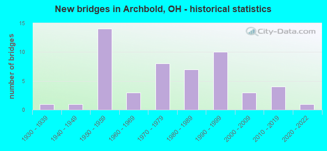
- New bridges - historical statistics
- 11930-1939
- 11940-1949
- 141950-1959
- 31960-1969
- 81970-1979
- 71980-1989
- 101990-1999
- 32000-2009
- 42010-2019
- 12020-2022

- Reconstructed bridges - Historical Statistics
- 11960-1969
- 11970-1979
- 41980-1989
- 31990-1999


- Bridge Condition - Deck
- 11.9%Excellent
- 11.9%Very good
- 47.6%Good
- 23.8%Satisfactory
- 4.8%Fair

- Bridge Condition - Superstructure
- 7.1%Excellent
- 19.0%Very good
- 38.1%Good
- 28.6%Satisfactory
- 7.1%Fair

- Bridge Condition - Substructure
- 7.1%Excellent
- 28.6%Very good
- 42.9%Good
- 19.0%Satisfactory
- 2.4%Fair

- Bridge Condition - Channel
- 2.5%Excellent
- 2.5%Very good
- 30.0%Good
- 52.5%Satisfactory
- 10.0%Fair
- 2.5%Poor

- Bridge Condition - Culverts
- 25.0%Excellent
- 25.0%Very good
- 25.0%Good
- 25.0%Satisfactory
Find on map >> Show street view
Structure Number: 2600099, Location: 2.2 mi. East of SR 66 (Lat: 41.543331, Lng: -84.264681), Route carried "on" structure: State highway 2, Year Built: 1973, Status: Open, Structure Length: 1.95m (6.40ft), Average Daily Traffic: 2,609 (year 2015), Truck Traffic: 5%, Average Future Daily Traffic: 3,621 (year 2035), Design Load: HS 20, Features Intersected: BRUSH CREEK
Minimum Vertical Clearance: 30+ m (98+ ft), Kilometerpoint: 12.167, Lanes on structure: 2, Owner: State Highway Agency, Approaching Roadway Width: 8.5m (27.9ft), Material/Design: Concrete continuous, Design/Construction: Slab, Number Of Spans In Main Unit: 3, Length of Maximum Span: 7.3m (24.0ft), Curb-To-Curb Width: 13.4m (44.0ft), Out-to-Out Width: 13.4m (44.0ft)
Condition: Deck: Good, Superstructure: Good, Substructure: Good, Channel: Good, Operating Rating: 58.3 metric tons, Method Used To Determine Operating Rating: Load Factor (LF) rating reported by rating factor (RF) method using MS18 loading, Inventory Rating: 35.6 metric tons, Method Used To Determine Inventory Rating: Load Factor (LF) rating reported by rating factor (RF) method using MS18 loading, Structural Evaluation: Better than present minimum criteria, Deck Geometry: Better than present minimum criteria, Waterway Adequacy: Superior to present desirable criteria, Approach Roadway Alignment: Superior to present desirable criteria, Designated Inspection Frequency: Every 24 months, Inspection Date: December 2020, Deck Structure Type: Concrete Cast-file-Place, Wearing Surface/Protective System: Wearing Surface: Bituminous
Find on map >> Show street view
Structure Number: 2600102, Location: 2.53 mi. East of SR 66 (Lat: 41.543381, Lng: -84.257911), Route carried "on" structure: State highway 2, Year Built: 1973, Status: Open, Structure Length: 1.59m (5.22ft), Average Daily Traffic: 2,609 (year 2015), Truck Traffic: 5%, Average Future Daily Traffic: 3,621 (year 2035), Design Load: HS 20, Features Intersected: EAST BRANCH BRUSH CREEK
Minimum Vertical Clearance: 30+ m (98+ ft), Kilometerpoint: 12.730, Lanes on structure: 2, Owner: State Highway Agency, Approaching Roadway Width: 8.5m (27.9ft), Skew: 3 degrees, Material/Design: Concrete continuous, Design/Construction: Slab, Number Of Spans In Main Unit: 3, Length of Maximum Span: 5.8m (19.0ft), Curb-To-Curb Width: 13.4m (44.0ft), Out-to-Out Width: 13.4m (44.0ft)
Condition: Deck: Satisfactory, Superstructure: Satisfactory, Substructure: Good, Channel: Good, Operating Rating: 42.1 metric tons, Method Used To Determine Operating Rating: Allowable Stress (AS) rating reported by rating factor (RF) method using MS18 loading, Inventory Rating: 32.4 metric tons, Method Used To Determine Inventory Rating: Allowable Stress (AS) rating reported by rating factor (RF) method using MS18 loading, Structural Evaluation: Equal to present minimum criteria, Deck Geometry: Better than present minimum criteria, Waterway Adequacy: Superior to present desirable criteria, Approach Roadway Alignment: Superior to present desirable criteria, Designated Inspection Frequency: Every 12 months, Inspection Date: September 2021, Deck Structure Type: Concrete Cast-file-Place, Wearing Surface/Protective System: Wearing Surface: Bituminous
Find on map >> Show street view
Structure Number: 2600439, Location: 0.46 Mi. W. of SR 66 (Lat: 41.580850, Lng: -84.333889), Route carried "on" structure: US 20A, Year Built: 1986, Status: Open, Structure Length: 6.71m (22.01ft), Average Daily Traffic: 3,113 (year 2015), Truck Traffic: 17%, Average Future Daily Traffic: 4,321 (year 2035), Design Load: HS 20+Mod, Features Intersected: TIFFIN RIVER
Minimum Vertical Clearance: 30+ m (98+ ft), Kilometerpoint: 4.072, Lanes on structure: 2, Base Highway Network: Yes, Owner: State Highway Agency, Approaching Roadway Width: 8.5m (27.9ft), Skew: 3 degrees, Material/Design: Steel continuous, Design/Construction: Stringer/Multi-beam, Number Of Spans In Main Unit: 3, Length of Maximum Span: 27.4m (89.9ft), Curb-To-Curb Width: 11.0m (36.1ft), Out-to-Out Width: 11.0m (36.1ft)
Condition: Deck: Good, Superstructure: Satisfactory, Substructure: Satisfactory, Channel: Fair, Operating Rating: 42.1 metric tons, Method Used To Determine Operating Rating: Allowable Stress (AS) rating reported by rating factor (RF) method using MS18 loading, Inventory Rating: 32.4 metric tons, Method Used To Determine Inventory Rating: Allowable Stress (AS) rating reported by rating factor (RF) method using MS18 loading, Structural Evaluation: Equal to present minimum criteria, Deck Geometry: Somewhat better than minimum adequacy, Waterway Adequacy: Equal to present desirable criteria, Approach Roadway Alignment: Equal to present desirable criteria, Designated Inspection Frequency: Every 12 months, Inspection Date: September 2021, Deck Structure Type: Concrete Cast-file-Place, Wearing Surface/Protective System: Wearing Surface: Monolithic Concrete, Deck Protection: Epoxy Coated Reinforcing
Find on map >> Show street view
Structure Number: 2600919, Location: 1.26 MILE NORTH OF CR A (Lat: 41.505119, Lng: -84.306431), Route carried "on" structure: State highway 66, Year Built: 1995, Status: Open, Structure Length: 2.19m (7.19ft), Average Daily Traffic: 8,306 (year 2015), Truck Traffic: 8%, Average Future Daily Traffic: 11,529 (year 2035), Design Load: HS 20+Mod, Features Intersected: BRUSH CREEK
Minimum Vertical Clearance: 30+ m (98+ ft), Kilometerpoint: 2.157, Lanes on structure: 2, Owner: State Highway Agency, Approaching Roadway Width: 12.2m (40.0ft), Skew: 1 degrees, Material/Design: Prestressed concrete, Design/Construction: Box Beam or Girders - Multiple, Number Of Spans In Main Unit: 1, Length of Maximum Span: 20.7m (67.9ft), Curb or Sidewalk Widths: Left: 1.5m (4.9ft), Right: 1.8m (5.9ft), Curb-To-Curb Width: 12.2m (40.0ft), Out-to-Out Width: 15.9m (52.2ft)
Condition: Deck: Very good, Superstructure: Very good, Substructure: Very good, Channel: Satisfactory, Operating Rating: 61.6 metric tons, Method Used To Determine Operating Rating: Load Factor (LF) rating reported by rating factor (RF) method using MS18 loading, Inventory Rating: 32.4 metric tons, Method Used To Determine Inventory Rating: Load Factor (LF) rating reported by rating factor (RF) method using MS18 loading, Structural Evaluation: Equal to present desirable criteria, Deck Geometry: Somewhat better than minimum adequacy, Waterway Adequacy: Superior to present desirable criteria, Approach Roadway Alignment: Equal to present desirable criteria, Designated Inspection Frequency: Every 24 months, Inspection Date: December 2020, Deck Structure Type: Concrete Cast-file-Place, Wearing Surface/Protective System: Wearing Surface: Monolithic Concrete, Deck Protection: Epoxy Coated Reinforcing
Find on map >> Show street view
Structure Number: 2600943, Location: 1/4 MI S OF CR F (Lat: 41.554169, Lng: -84.306739), Route carried "on" structure: State highway 66, Year Built: 1990, Status: Open, Structure Length: 0.79m (2.59ft), Average Daily Traffic: 4,141 (year 2015), Truck Traffic: 8%, Average Future Daily Traffic: 5,748 (year 2035), Design Load: HS 20+Mod, Features Intersected: GRASS RUN CREEK
Minimum Vertical Clearance: 30+ m (98+ ft), Kilometerpoint: 7.564, Lanes on structure: 2, Owner: State Highway Agency, Approaching Roadway Width: 8.5m (27.9ft), Material/Design: Concrete, Design/Construction: Culvert, Number Of Spans In Main Unit: 1, Length of Maximum Span: 7.3m (24.0ft)
Condition: Channel: Satisfactory, Culverts: Good, Operating Rating: 42.1 metric tons, Method Used To Determine Operating Rating: Assigned rating based on Load Factor Design (LFD) reported by rating factor (RF) using MS18 loading, Inventory Rating: 32.4 metric tons, Method Used To Determine Inventory Rating: Assigned rating based on Load Factor Design (LFD) reported by rating factor (RF) using MS18 loading, Structural Evaluation: Better than present minimum criteria, Waterway Adequacy: Equal to present desirable criteria, Approach Roadway Alignment: Equal to present desirable criteria, Designated Inspection Frequency: Every 24 months, Inspection Date: December 2020
Find on map >> Show street view
Structure Number: 2601125, Location: 0.9 MI. NORTH OF ROAD H (Lat: 41.599431, Lng: -84.326431), Route carried "on" structure: State highway 66, Year Built: 1998, Status: Open, Structure Length: 1.16m (3.81ft), Average Daily Traffic: 2,494 (year 2015), Truck Traffic: 14%, Average Future Daily Traffic: 3,462 (year 2035), Design Load: HS 20+Mod, Features Intersected: OVERFLOW
Minimum Vertical Clearance: 30+ m (98+ ft), Kilometerpoint: 13.760, Lanes on structure: 2, Owner: State Highway Agency, Approaching Roadway Width: 9.8m (32.2ft), Material/Design: Concrete, Design/Construction: Culvert, Number Of Spans In Main Unit: 1, Length of Maximum Span: 4.9m (16.1ft)
Condition: Channel: Good, Culverts: Very good, Operating Rating: 61.6 metric tons, Method Used To Determine Operating Rating: Load Factor (LF) rating reported by rating factor (RF) method using MS18 loading, Inventory Rating: 35.6 metric tons, Method Used To Determine Inventory Rating: Load Factor (LF) rating reported by rating factor (RF) method using MS18 loading, Structural Evaluation: Equal to present desirable criteria, Waterway Adequacy: Equal to present desirable criteria, Approach Roadway Alignment: Equal to present minimum criteria, Designated Inspection Frequency: Every 24 months, Inspection Date: December 2020
Find on map >> Show street view
Structure Number: 2601176, Location: 0.8 MI. NORTH OF CR H (Lat: 41.598561, Lng: -84.326419), Route carried "on" structure: State highway 66, Year Built: 1988, Year Reconstructed: 1998, Status: Open, Structure Length: 7.19m (23.59ft), Average Daily Traffic: 2,494 (year 2015), Truck Traffic: 14%, Average Future Daily Traffic: 3,462 (year 2035), Design Load: HS 20+Mod, Features Intersected: TIFFIN RIVER
Minimum Vertical Clearance: 30+ m (98+ ft), Kilometerpoint: 13.679, Lanes on structure: 2, Owner: State Highway Agency, Approaching Roadway Width: 9.8m (32.2ft), Skew: 3 degrees, Material/Design: Prestressed concrete, Design/Construction: Box Beam or Girders - Multiple, Number Of Spans In Main Unit: 3, Length of Maximum Span: 23.2m (76.1ft), Curb-To-Curb Width: 12.2m (40.0ft), Out-to-Out Width: 12.2m (40.0ft)
Condition: Deck: Good, Superstructure: Good, Substructure: Good, Channel: Satisfactory, Operating Rating: 97.2 metric tons, Method Used To Determine Operating Rating: Load Factor (LF) rating reported by rating factor (RF) method using MS18 loading, Inventory Rating: 68.0 metric tons, Method Used To Determine Inventory Rating: Load Factor (LF) rating reported by rating factor (RF) method using MS18 loading, Structural Evaluation: Better than present minimum criteria, Deck Geometry: Equal to present minimum criteria, Waterway Adequacy: Equal to present desirable criteria, Approach Roadway Alignment: Equal to present minimum criteria, Designated Inspection Frequency: Every 24 months, Inspection Date: October 2020, Deck Structure Type: Concrete Cast-file-Place, Wearing Surface/Protective System: Wearing Surface: Integral Concrete
Find on map >> Show street view
Structure Number: 2629135, Location: 1.2MI WEST OF EXIT 25 (Lat: 41.587439, Lng: -84.342519), Route carried "on" structure: County highway C0025, Year Built: 1954, Status: Open, Structure Length: 6.34m (20.80ft), Average Daily Traffic: 22,000 (year 1990), Truck Traffic: 27%, Average Future Daily Traffic: 30,919 (year 2010), Design Load: HS 20, Features Intersected: I80 OHIO TPK, Facility Carried by Structure: FULTON WILLIAMS RD
Minimum Vertical Clearance: 30+ m (98+ ft), Kilometerpoint: 160.918, Lanes on structure: 2, Lanes under structure: 4, Owner: State Toll Authority, Approaching Roadway Width: 8.5m (27.9ft), Material/Design: Steel continuous, Design/Construction: Stringer/Multi-beam, Number Of Spans In Main Unit: 2, Number Of Approach Spans: 2, Length of Maximum Span: 22.6m (74.1ft), Curb-To-Curb Width: 7.9m (25.9ft), Out-to-Out Width: 8.8m (28.9ft)
Condition: Deck: Excellent, Superstructure: Satisfactory, Substructure: Good, Operating Rating: 51.8 metric tons, Method Used To Determine Operating Rating: Load Factor (LF) rating reported by rating factor (RF) method using MS18 loading, Inventory Rating: 32.4 metric tons, Method Used To Determine Inventory Rating: Load Factor (LF) rating reported by rating factor (RF) method using MS18 loading, Structural Evaluation: Equal to present minimum criteria, Deck Geometry: High priority of corrective action, Underclear: High priority of corrective action, Approach Roadway Alignment: Equal to present desirable criteria, Designated Inspection Frequency: Every 12 months, Inspection Date: April 2021, Deck Structure Type: Concrete Cast-file-Place, Wearing Surface/Protective System: Wearing Surface: Latex Concrete
Find on map >> Show street view
Structure Number: 2629151, Location: 0.9MI WEST OF EXIT 25 (Lat: 41.587919, Lng: -84.337850), Route carried "on" structure: Interstate 80K, Year Built: 1954, Year Reconstructed: 1989, Status: Open, Structure Length: 7.47m (24.51ft), Average Daily Traffic: 11,138 (year 2015), Truck Traffic: 27%, Average Future Daily Traffic: 15,460 (year 2035), Design Load: HS 20, Features Intersected: TIFFIN RIVER, Facility Carried by Structure: I80 OH TPK EB
Minimum Vertical Clearance: 30+ m (98+ ft), Kilometerpoint: 4.007, Lanes on structure: 2, Base Highway Network: Yes, Toll: On toll road, Owner: State Toll Authority, Approaching Roadway Width: 13.4m (44.0ft), Material/Design: Steel continuous, Design/Construction: Stringer/Multi-beam, Number Of Spans In Main Unit: 3, Length of Maximum Span: 24.4m (80.1ft), Curb-To-Curb Width: 11.4m (37.4ft), Out-to-Out Width: 12.3m (40.4ft)
Condition: Deck: Good, Superstructure: Very good, Substructure: Good, Channel: Satisfactory, Operating Rating: 68.0 metric tons, Method Used To Determine Operating Rating: Load Factor (LF) rating reported by rating factor (RF) method using MS18 loading, Inventory Rating: 42.1 metric tons, Method Used To Determine Inventory Rating: Load Factor (LF) rating reported by rating factor (RF) method using MS18 loading, Structural Evaluation: Better than present minimum criteria, Deck Geometry: Somewhat better than minimum adequacy, Waterway Adequacy: Equal to present desirable criteria, Approach Roadway Alignment: Equal to present desirable criteria, Designated Inspection Frequency: Every 24 months, Inspection Date: April 2021, Deck Structure Type: Concrete Cast-file-Place, Wearing Surface/Protective System: Wearing Surface: Monolithic Concrete, Deck Protection: Epoxy Coated Reinforcing
Find on map >> Show street view
Structure Number: 2629178, Location: 0.9MI WEST OF EXIT 25 (Lat: 41.588119, Lng: -84.337950), Route carried "on" structure: Interstate 80K, Year Built: 1954, Year Reconstructed: 1989, Status: Open, Structure Length: 7.47m (24.51ft), Average Daily Traffic: 11,138 (year 2015), Truck Traffic: 27%, Average Future Daily Traffic: 15,460 (year 2035), Design Load: HS 20, Features Intersected: TIFFIN RIVER, Facility Carried by Structure: I80 OH TPK WB
Minimum Vertical Clearance: 30+ m (98+ ft), Kilometerpoint: 4.007, Lanes on structure: 2, Base Highway Network: Yes, Toll: On toll road, Owner: State Toll Authority, Approaching Roadway Width: 13.4m (44.0ft), Material/Design: Steel continuous, Design/Construction: Stringer/Multi-beam, Number Of Spans In Main Unit: 3, Length of Maximum Span: 24.4m (80.1ft), Curb-To-Curb Width: 11.4m (37.4ft), Out-to-Out Width: 12.3m (40.4ft)
Condition: Deck: Good, Superstructure: Very good, Substructure: Good, Channel: Satisfactory, Operating Rating: 68.0 metric tons, Method Used To Determine Operating Rating: Load Factor (LF) rating reported by rating factor (RF) method using MS18 loading, Inventory Rating: 42.1 metric tons, Method Used To Determine Inventory Rating: Load Factor (LF) rating reported by rating factor (RF) method using MS18 loading, Structural Evaluation: Better than present minimum criteria, Deck Geometry: Somewhat better than minimum adequacy, Waterway Adequacy: Equal to present minimum criteria, Approach Roadway Alignment: Equal to present desirable criteria, Designated Inspection Frequency: Every 24 months, Inspection Date: April 2021, Deck Structure Type: Concrete Cast-file-Place, Wearing Surface/Protective System: Wearing Surface: Monolithic Concrete, Deck Protection: Epoxy Coated Reinforcing
Find on map >> Show street view
Structure Number: 2629208, Location: 0.3 MI WEST OF EXIT 25 (Lat: 41.590450, Lng: -84.326331), Route carried "on" structure: State highway 66, Year Built: 1998, Status: Open, Structure Length: 6.68m (21.92ft), Average Daily Traffic: 2,494 (year 2015), Truck Traffic: 14%, Average Future Daily Traffic: 3,462 (year 2035), Design Load: HS 20+Mod, Features Intersected: I80 OHIO TPK
Minimum Vertical Clearance: 30+ m (98+ ft), Kilometerpoint: 11.893, Lanes on structure: 2, Lanes under structure: 4, Owner: State Toll Authority, Approaching Roadway Width: 12.2m (40.0ft), Skew: 1 degrees, Material/Design: Steel continuous, Design/Construction: Stringer/Multi-beam, Number Of Spans In Main Unit: 2, Length of Maximum Span: 29.3m (96.1ft), Curb-To-Curb Width: 12.2m (40.0ft), Out-to-Out Width: 13.1m (43.0ft)
Condition: Deck: Good, Superstructure: Good, Substructure: Very good, Operating Rating: 90.7 metric tons, Method Used To Determine Operating Rating: Load Factor (LF) rating reported by rating factor (RF) method using MS18 loading, Inventory Rating: 55.1 metric tons, Method Used To Determine Inventory Rating: Load Factor (LF) rating reported by rating factor (RF) method using MS18 loading, Structural Evaluation: Better than present minimum criteria, Deck Geometry: Equal to present minimum criteria, Underclear: High priority of corrective action, Approach Roadway Alignment: Equal to present minimum criteria, Designated Inspection Frequency: Every 24 months, Inspection Date: April 2021, Deck Structure Type: Concrete Cast-file-Place, Wearing Surface/Protective System: Wearing Surface: Monolithic Concrete, Deck Protection: Epoxy Coated Reinforcing
Find on map >> Show street view
Structure Number: 2629216, Location: 0.7MI WEST OF EXIT 25 (Lat: 41.591461, Lng: -84.307089), Route carried "on" structure: County highway C0023, Year Built: 1954, Year Reconstructed: 1989, Status: Open, Structure Length: 5.85m (19.19ft), Average Daily Traffic: 698 (year 2015), Truck Traffic: 8%, Average Future Daily Traffic: 31,188 (year 2035), Design Load: HS 20, Features Intersected: I80 OHIO TPK, Facility Carried by Structure: CR0023
Minimum Vertical Clearance: 30+ m (98+ ft), Kilometerpoint: 4.989, Lanes on structure: 2, Lanes under structure: 4, Base Highway Network: Yes, Owner: State Toll Authority, Approaching Roadway Width: 12.2m (40.0ft), Material/Design: Steel continuous, Design/Construction: Stringer/Multi-beam, Number Of Spans In Main Unit: 2, Number Of Approach Spans: 2, Length of Maximum Span: 20.1m (65.9ft), Curb-To-Curb Width: 9.4m (30.8ft), Out-to-Out Width: 10.3m (33.8ft)
Condition: Deck: Satisfactory, Superstructure: Satisfactory, Substructure: Good, Operating Rating: 58.3 metric tons, Method Used To Determine Operating Rating: Load Factor (LF) rating reported by rating factor (RF) method using MS18 loading, Inventory Rating: 35.6 metric tons, Method Used To Determine Inventory Rating: Load Factor (LF) rating reported by rating factor (RF) method using MS18 loading, Structural Evaluation: Equal to present minimum criteria, Deck Geometry: Equal to present minimum criteria, Underclear: High priority of corrective action, Approach Roadway Alignment: Equal to present desirable criteria, Designated Inspection Frequency: Every 12 months, Inspection Date: May 2021, Deck Structure Type: Concrete Cast-file-Place, Wearing Surface/Protective System: Wearing Surface: Monolithic Concrete
Find on map >> Show street view
Structure Number: 2629224, Location: EXIT 25 RAMP (Lat: 41.591639, Lng: -84.320111), Route carried "on" structure: Ramp Interstate 80K, Year Built: 1996, Status: Open, Structure Length: 9.69m (31.79ft), Average Daily Traffic: 2,000 (year 1970), Truck Traffic: 20%, Average Future Daily Traffic: 30,640 (year 1990), Design Load: HS 20+Mod, Features Intersected: I80 OHIO TPK, Facility Carried by Structure: OH TPK EXIT RAMP
Minimum Vertical Clearance: 30+ m (98+ ft), Kilometerpoint: 5.552, Lanes on structure: 2, Lanes under structure: 5, Toll: On toll road, Owner: State Toll Authority, Approaching Roadway Width: 19.8m (65.0ft), Skew: 20 degrees, Material/Design: Steel continuous, Design/Construction: Stringer/Multi-beam, Number Of Spans In Main Unit: 4, Length of Maximum Span: 29.9m (98.1ft), Curb-To-Curb Width: 19.8m (65.0ft), Out-to-Out Width: 20.7m (67.9ft)
Condition: Deck: Very good, Superstructure: Good, Substructure: Very good, Operating Rating: 84.2 metric tons, Method Used To Determine Operating Rating: Load Factor (LF) rating reported by rating factor (RF) method using MS18 loading, Inventory Rating: 48.6 metric tons, Method Used To Determine Inventory Rating: Load Factor (LF) rating reported by rating factor (RF) method using MS18 loading, Structural Evaluation: Better than present minimum criteria, Deck Geometry: Superior to present desirable criteria, Underclear: Meets minimum limits, Approach Roadway Alignment: Equal to present desirable criteria, Designated Inspection Frequency: Every 24 months, Inspection Date: April 2021, Deck Structure Type: Concrete Cast-file-Place, Wearing Surface/Protective System: Wearing Surface: Monolithic Concrete, Deck Protection: Epoxy Coated Reinforcing
Find on map >> Show street view
Structure Number: 2629259, Location: 7.6MI WEST OF EXIT 34 (Lat: 41.590500, Lng: -84.287850), Route carried "on" structure: County highway C0022, Year Built: 1954, Status: Open, Structure Length: 5.85m (19.19ft), Average Daily Traffic: 22,000 (year 1990), Truck Traffic: 27%, Average Future Daily Traffic: 31,188 (year 2010), Design Load: HS 20, Features Intersected: I80 OHIO TPK, Facility Carried by Structure: SPIES HANDY RD
Minimum Vertical Clearance: 30+ m (98+ ft), Kilometerpoint: 0.322, Lanes on structure: 2, Lanes under structure: 4, Owner: State Toll Authority, Approaching Roadway Width: 7.3m (24.0ft), Material/Design: Steel continuous, Design/Construction: Stringer/Multi-beam, Number Of Spans In Main Unit: 2, Number Of Approach Spans: 2, Length of Maximum Span: 20.1m (65.9ft), Curb-To-Curb Width: 7.9m (25.9ft), Out-to-Out Width: 8.8m (28.9ft)
Condition: Deck: Excellent, Superstructure: Fair, Substructure: Good, Operating Rating: 35.6 metric tons, Method Used To Determine Operating Rating: Load Factor (LF) rating reported by rating factor (RF) method using MS18 loading, Inventory Rating: 22.7 metric tons, Method Used To Determine Inventory Rating: Load Factor (LF) rating reported by rating factor (RF) method using MS18 loading, Structural Evaluation: Somewhat better than minimum adequacy, Deck Geometry: High priority of replacement, Underclear: High priority of corrective action, Approach Roadway Alignment: Equal to present desirable criteria, Designated Inspection Frequency: Every 12 months, Inspection Date: April 2021, Deck Structure Type: Concrete Cast-file-Place, Wearing Surface/Protective System: Wearing Surface: Latex Concrete
Find on map >> Show street view
Structure Number: 2629275, Location: 6.6MI WEST OF EXIT 34 (Lat: 41.590581, Lng: -84.268539), Route carried "on" structure: County highway C0021, Year Built: 1954, Status: Posted for load, Structure Length: 5.85m (19.19ft), Average Daily Traffic: 274 (year 2015), Truck Traffic: 7%, Average Future Daily Traffic: 31,188 (year 2035), Design Load: HS 20, Features Intersected: I80 OHIO TPK, Facility Carried by Structure: LAUBER HILL RD
Minimum Vertical Clearance: 30+ m (98+ ft), Kilometerpoint: 0.322, Lanes on structure: 2, Lanes under structure: 4, Owner: State Toll Authority, Approaching Roadway Width: 8.5m (27.9ft), Material/Design: Steel continuous, Design/Construction: Stringer/Multi-beam, Number Of Spans In Main Unit: 2, Number Of Approach Spans: 2, Length of Maximum Span: 20.1m (65.9ft), Curb-To-Curb Width: 7.9m (25.9ft), Out-to-Out Width: 8.8m (28.9ft)
Condition: Deck: Satisfactory, Superstructure: Satisfactory, Substructure: Very good, Operating Rating: 29.2 metric tons, Method Used To Determine Operating Rating: Load Factor (LF) rating reported by rating factor (RF) method using MS18 loading, Inventory Rating: 19.4 metric tons, Method Used To Determine Inventory Rating: Load Factor (LF) rating reported by rating factor (RF) method using MS18 loading, Structural Evaluation: Somewhat better than minimum adequacy, Deck Geometry: Somewhat better than minimum adequacy, Underclear: High priority of corrective action, Approach Roadway Alignment: Equal to present desirable criteria, Bridge Posting: Required (Relationship of Operating Rating to Maximum Legal Load: 20.0 - 29.9% below), Designated Inspection Frequency: Every 12 months, Inspection Date: May 2021, Deck Structure Type: Concrete Cast-file-Place, Wearing Surface/Protective System: Wearing Surface: Latex Concrete
Find on map >> Show street view
Structure Number: 2630002, Location: TR 26 0.5 Mi. N. of CR D (Lat: 41.536131, Lng: -84.361561), Route carried "on" structure: County highway T26D0, Year Built: 2015, Status: Open, Structure Length: 1.40m (4.59ft), Average Daily Traffic: 180 (year 2015), Truck Traffic: 21%, Average Future Daily Traffic: 250 (year 2035), Design Load: HL 93, Features Intersected: Flat Run, Facility Carried by Structure: Bridge 26D.5
Minimum Vertical Clearance: 30+ m (98+ ft), Kilometerpoint: 0.805, Lanes on structure: 2, Owner: County Highway Agency, Approaching Roadway Width: 8.5m (27.9ft), Skew: 3 degrees, Material/Design: Prestressed concrete, Design/Construction: Box Beam or Girders - Multiple, Number Of Spans In Main Unit: 1, Length of Maximum Span: 13.0m (42.7ft), Curb-To-Curb Width: 8.5m (27.9ft), Out-to-Out Width: 8.5m (27.9ft)
Condition: Deck: Excellent, Superstructure: Excellent, Substructure: Excellent, Channel: Satisfactory, Operating Rating: 68.0 metric tons, Method Used To Determine Operating Rating: Load and Resistance Factor Rating (LRFR) rating reported by rating factor(RF) method using HL-93 loadings, Inventory Rating: 51.8 metric tons, Method Used To Determine Inventory Rating: Load and Resistance Factor Rating (LRFR) rating reported by rating factor(RF) method using HL-93 loadings, Structural Evaluation: Superior to present desirable criteria, Deck Geometry: Equal to present minimum criteria, Waterway Adequacy: Equal to present desirable criteria, Approach Roadway Alignment: Equal to present desirable criteria, Designated Inspection Frequency: Every 24 months, Inspection Date: November 2021, Deck Structure Type: Concrete Cast-file-Place, Wearing Surface/Protective System: Wearing Surface: Bituminous, Membrane: Preformed Fabric, Deck Protection: Epoxy Coated Reinforcing
Find on map >> Show street view
Structure Number: 2630206, Location: 1.1 MI. W. OF TR 21-3 (Lat: 41.485769, Lng: -84.303219), Route carried "on" structure: County highway CA213, Year Built: 2010, Status: Open, Structure Length: 1.07m (3.51ft), Average Daily Traffic: 669 (year 2015), Truck Traffic: 12%, Average Future Daily Traffic: 929 (year 2035), Design Load: HL 93, Features Intersected: GERMAN-HENRY-2, Facility Carried by Structure: Bridge A21-31.1
Minimum Vertical Clearance: 30+ m (98+ ft), Kilometerpoint: 50.051, Lanes on structure: 2, Owner: County Highway Agency, Approaching Roadway Width: 11.0m (36.1ft), Skew: 2 degrees, Material/Design: Prestressed concrete, Design/Construction: Box Beam or Girders - Multiple, Number Of Spans In Main Unit: 1, Length of Maximum Span: 10.4m (34.1ft), Curb-To-Curb Width: 9.8m (32.2ft), Out-to-Out Width: 9.8m (32.2ft)
Condition: Deck: Very good, Superstructure: Very good, Substructure: Very good, Channel: Satisfactory, Operating Rating: 87.5 metric tons, Method Used To Determine Operating Rating: Load Factor (LF) rating reported by rating factor (RF) method using MS18 loading, Inventory Rating: 51.8 metric tons, Method Used To Determine Inventory Rating: Load Factor (LF) rating reported by rating factor (RF) method using MS18 loading, Structural Evaluation: Equal to present desirable criteria, Deck Geometry: Equal to present minimum criteria, Waterway Adequacy: Superior to present desirable criteria, Approach Roadway Alignment: Equal to present desirable criteria, Designated Inspection Frequency: Every 24 months, Inspection Date: November 2021, Deck Structure Type: Concrete Cast-file-Place, Wearing Surface/Protective System: Wearing Surface: Bituminous, Membrane: Preformed Fabric
Find on map >> Show street view
Structure Number: 2630583, Location: 0.3 MI. W. OF CR 21 (Lat: 41.528819, Lng: -84.273161), Route carried "on" structure: County highway C000D, Year Built: 1959, Year Reconstructed: 1972, Status: Open, Structure Length: 2.42m (7.94ft), Average Daily Traffic: 1,298 (year 2015), Truck Traffic: 4%, Average Future Daily Traffic: 1,802 (year 2035), Design Load: HS 15, Features Intersected: BRUSH CREEK, Facility Carried by Structure: Bridge D21.3
Minimum Vertical Clearance: 30+ m (98+ ft), Kilometerpoint: 0.483, Lanes on structure: 2, Owner: County Highway Agency, Approaching Roadway Width: 11.0m (36.1ft), Material/Design: Concrete continuous, Design/Construction: Slab, Number Of Spans In Main Unit: 3, Length of Maximum Span: 9.1m (29.9ft), Curb-To-Curb Width: 11.0m (36.1ft), Out-to-Out Width: 11.0m (36.1ft)
Condition: Deck: Satisfactory, Superstructure: Satisfactory, Substructure: Satisfactory, Channel: Satisfactory, Operating Rating: 51.8 metric tons, Method Used To Determine Operating Rating: Load Factor (LF) rating reported by rating factor (RF) method using MS18 loading, Inventory Rating: 32.4 metric tons, Method Used To Determine Inventory Rating: Load Factor (LF) rating reported by rating factor (RF) method using MS18 loading, Structural Evaluation: Equal to present minimum criteria, Deck Geometry: Equal to present minimum criteria, Waterway Adequacy: Superior to present desirable criteria, Approach Roadway Alignment: Equal to present desirable criteria, Designated Inspection Frequency: Every 12 months, Inspection Date: November 2021, Deck Structure Type: Concrete Cast-file-Place, Wearing Surface/Protective System: Wearing Surface: Bituminous, Membrane: Preformed Fabric
Find on map >> Show street view
Structure Number: 2630621, Location: .1 M. W. OF TWP. RD. 21-3 (Lat: 41.514281, Lng: -84.283889), Route carried "on" structure: County highway CC213, Year Built: 2006, Status: Open, Structure Length: 2.41m (7.91ft), Average Daily Traffic: 3,296 (year 2015), Truck Traffic: 3%, Average Future Daily Traffic: 4,575 (year 2035), Design Load: HS 20, Features Intersected: BRUSH CREEK, Facility Carried by Structure: Bridge C21-3.1
Minimum Vertical Clearance: 30+ m (98+ ft), Kilometerpoint: 0.161, Lanes on structure: 2, Owner: County Highway Agency, Approaching Roadway Width: 12.2m (40.0ft), Material/Design: Prestressed concrete continuous, Design/Construction: Box Beam or Girders - Multiple, Number Of Spans In Main Unit: 3, Length of Maximum Span: 9.1m (29.9ft), Curb-To-Curb Width: 12.2m (40.0ft), Out-to-Out Width: 12.2m (40.0ft)
Condition: Deck: Good, Superstructure: Good, Substructure: Very good, Channel: Satisfactory, Operating Rating: 87.5 metric tons, Method Used To Determine Operating Rating: Load Factor (LF) rating reported by rating factor (RF) method using MS18 loading, Inventory Rating: 51.8 metric tons, Method Used To Determine Inventory Rating: Load Factor (LF) rating reported by rating factor (RF) method using MS18 loading, Structural Evaluation: Better than present minimum criteria, Deck Geometry: Equal to present minimum criteria, Waterway Adequacy: Superior to present desirable criteria, Approach Roadway Alignment: Equal to present desirable criteria, Designated Inspection Frequency: Every 24 months, Inspection Date: November 2021, Deck Structure Type: Concrete Cast-file-Place, Wearing Surface/Protective System: Wearing Surface: Bituminous, Membrane: Preformed Fabric, Deck Protection: Epoxy Coated Reinforcing
Find on map >> Show street view
Structure Number: 2630885, Location: TR G 0.4 MI. W. OF TR 24 (Lat: 41.572231, Lng: -84.333111), Route carried "on" structure: County highway T000G, Year Built: 1972, Status: Open, Structure Length: 2.87m (9.42ft), Average Daily Traffic: 885 (year 2015), Truck Traffic: 16%, Average Future Daily Traffic: 1,228 (year 2035), Design Load: HS 20, Features Intersected: TIFFIN OVERFLOW, Facility Carried by Structure: Bridge G24.4
Minimum Vertical Clearance: 30+ m (98+ ft), Kilometerpoint: 0.644, Lanes on structure: 2, Owner: County Highway Agency, Approaching Roadway Width: 9.8m (32.2ft), Material/Design: Steel continuous, Design/Construction: Stringer/Multi-beam, Number Of Spans In Main Unit: 2, Length of Maximum Span: 14.3m (46.9ft), Curb-To-Curb Width: 8.5m (27.9ft), Out-to-Out Width: 8.5m (27.9ft)
Condition: Deck: Fair, Superstructure: Good, Substructure: Satisfactory, Channel: Very good, Operating Rating: 45.4 metric tons, Method Used To Determine Operating Rating: Load Factor (LF) rating reported by rating factor (RF) method using MS18 loading, Inventory Rating: 29.2 metric tons, Method Used To Determine Inventory Rating: Load Factor (LF) rating reported by rating factor (RF) method using MS18 loading, Structural Evaluation: Equal to present minimum criteria, Deck Geometry: Somewhat better than minimum adequacy, Waterway Adequacy: Somewhat better than minimum adequacy, Approach Roadway Alignment: Equal to present desirable criteria, Designated Inspection Frequency: Every 12 months, Inspection Date: November 2021, Deck Structure Type: Corrugated Steel, Wearing Surface/Protective System: Wearing Surface: Bituminous
Find on map >> Show street view
Structure Number: 2630893, Location: TR G 0.6 MI. W. OF TR 24 (Lat: 41.572239, Lng: -84.338089), Route carried "on" structure: County highway T000G, Year Built: 1971, Status: Open, Structure Length: 5.00m (16.40ft), Average Daily Traffic: 844 (year 2015), Truck Traffic: 17%, Average Future Daily Traffic: 1,171 (year 2035), Design Load: HS 20, Features Intersected: TIFFIN RIVER, Facility Carried by Structure: Bridge G24.6
Minimum Vertical Clearance: 30+ m (98+ ft), Kilometerpoint: 0.966, Lanes on structure: 2, Owner: County Highway Agency, Approaching Roadway Width: 11.0m (36.1ft), Skew: 5 degrees, Material/Design: Steel continuous, Design/Construction: Stringer/Multi-beam, Number Of Spans In Main Unit: 3, Length of Maximum Span: 19.5m (64.0ft), Curb-To-Curb Width: 8.5m (27.9ft), Out-to-Out Width: 8.5m (27.9ft)
Condition: Deck: Fair, Superstructure: Good, Substructure: Satisfactory, Channel: Poor, Operating Rating: 94.0 metric tons, Method Used To Determine Operating Rating: Load Factor (LF) rating reported by rating factor (RF) method using MS18 loading, Inventory Rating: 58.3 metric tons, Method Used To Determine Inventory Rating: Load Factor (LF) rating reported by rating factor (RF) method using MS18 loading, Structural Evaluation: Equal to present minimum criteria, Deck Geometry: Somewhat better than minimum adequacy, Waterway Adequacy: Somewhat better than minimum adequacy, Approach Roadway Alignment: Equal to present desirable criteria, Designated Inspection Frequency: Every 12 months, Inspection Date: November 2021, Deck Structure Type: Corrugated Steel, Wearing Surface/Protective System: Wearing Surface: Bituminous
Find on map >> Show street view
Structure Number: 2630907, Location: TR G 0.3 MI. W. TR 24-3 (Lat: 41.572189, Lng: -84.344789), Route carried "on" structure: County highway TG243, Year Built: 1972, Status: Open, Structure Length: 1.55m (5.09ft), Average Daily Traffic: 908 (year 2015), Truck Traffic: 9%, Average Future Daily Traffic: 1,260 (year 2035), Design Load: HS 20, Features Intersected: BATES CREEK, Facility Carried by Structure: Bridge G24-3.3
Minimum Vertical Clearance: 30+ m (98+ ft), Kilometerpoint: 0.483, Lanes on structure: 2, Owner: County Highway Agency, Approaching Roadway Width: 11.0m (36.1ft), Material/Design: Steel, Design/Construction: Stringer/Multi-beam, Number Of Spans In Main Unit: 1, Length of Maximum Span: 14.9m (48.9ft), Curb-To-Curb Width: 8.5m (27.9ft), Out-to-Out Width: 8.5m (27.9ft)
Condition: Deck: Satisfactory, Superstructure: Good, Substructure: Very good, Channel: Good, Operating Rating: 42.1 metric tons, Method Used To Determine Operating Rating: Allowable Stress (AS) rating reported by rating factor (RF) method using MS18 loading, Inventory Rating: 25.9 metric tons, Method Used To Determine Inventory Rating: Allowable Stress (AS) rating reported by rating factor (RF) method using MS18 loading, Structural Evaluation: Equal to present minimum criteria, Deck Geometry: Somewhat better than minimum adequacy, Waterway Adequacy: Somewhat better than minimum adequacy, Approach Roadway Alignment: Equal to present desirable criteria, Designated Inspection Frequency: Every 12 months, Inspection Date: November 2021, Deck Structure Type: Corrugated Steel, Wearing Surface/Protective System: Wearing Surface: Bituminous
Find on map >> Show street view
Structure Number: 2631105, Location: 0.2 MI. WEST OF RD. 23 (Lat: 41.601131, Lng: -84.311950), Route carried "on" structure: County highway C000J, Year Built: 1958, Status: Open, Structure Length: 5.64m (18.50ft), Average Daily Traffic: 165 (year 2015), Truck Traffic: 11%, Average Future Daily Traffic: 229 (year 2035), Design Load: H 15, Features Intersected: TIFFIN RIVER, Facility Carried by Structure: Bridge J23.2
Minimum Vertical Clearance: 30+ m (98+ ft), Kilometerpoint: 0.322, Lanes on structure: 2, Owner: County Highway Agency, Approaching Roadway Width: 11.0m (36.1ft), Material/Design: Steel continuous, Design/Construction: Stringer/Multi-beam, Number Of Spans In Main Unit: 3, Length of Maximum Span: 21.3m (69.9ft), Curb-To-Curb Width: 10.4m (34.1ft), Out-to-Out Width: 10.4m (34.1ft)
Condition: Deck: Good, Superstructure: Satisfactory, Substructure: Satisfactory, Channel: Satisfactory, Operating Rating: 51.8 metric tons, Method Used To Determine Operating Rating: Load Factor (LF) rating reported by rating factor (RF) method using MS18 loading, Inventory Rating: 32.4 metric tons, Method Used To Determine Inventory Rating: Load Factor (LF) rating reported by rating factor (RF) method using MS18 loading, Structural Evaluation: Equal to present minimum criteria, Deck Geometry: Better than present minimum criteria, Waterway Adequacy: Superior to present desirable criteria, Approach Roadway Alignment: Superior to present desirable criteria, Designated Inspection Frequency: Every 12 months, Inspection Date: November 2021, Deck Structure Type: Concrete Cast-file-Place, Wearing Surface/Protective System: Wearing Surface: Integral Concrete
Find on map >> Show street view
Structure Number: 2634422, Location: 0.9 MI. N. OF TR B (Lat: 41.513211, Lng: -84.267750), Route carried "on" structure: County highway C21B0, Year Built: 1984, Status: Open, Structure Length: 0.77m (2.53ft), Average Daily Traffic: 445 (year 2015), Truck Traffic: 2%, Average Future Daily Traffic: 618 (year 2035), Design Load: HS 20, Features Intersected: BR4 BRUSH CREEK, Facility Carried by Structure: Bridge 21B.9
Minimum Vertical Clearance: 30+ m (98+ ft), Kilometerpoint: 1.448, Lanes on structure: 2, Owner: County Highway Agency, Approaching Roadway Width: 8.5m (27.9ft), Skew: 4 degrees, Material/Design: Prestressed concrete, Design/Construction: Box Beam or Girders - Multiple, Number Of Spans In Main Unit: 1, Length of Maximum Span: 7.0m (23.0ft), Curb-To-Curb Width: 8.5m (27.9ft), Out-to-Out Width: 8.5m (27.9ft)
Condition: Deck: Good, Superstructure: Good, Substructure: Good, Channel: Satisfactory, Operating Rating: 97.2 metric tons, Method Used To Determine Operating Rating: Load Factor (LF) rating reported by rating factor (RF) method using MS18 loading, Inventory Rating: 68.0 metric tons, Method Used To Determine Inventory Rating: Load Factor (LF) rating reported by rating factor (RF) method using MS18 loading, Structural Evaluation: Better than present minimum criteria, Deck Geometry: Somewhat better than minimum adequacy, Waterway Adequacy: Equal to present desirable criteria, Approach Roadway Alignment: Equal to present desirable criteria, Designated Inspection Frequency: Every 24 months, Inspection Date: November 2021, Deck Structure Type: Concrete Cast-file-Place, Wearing Surface/Protective System: Wearing Surface: Bituminous, Membrane: Preformed Fabric
Find on map >> Show street view
Structure Number: 2634465, Location: .9 MILE NORTH OF ROAD C (Lat: 41.527231, Lng: -84.267719), Route carried "on" structure: County highway C0021, Year Built: 1959, Year Reconstructed: 1999, Status: Open, Structure Length: 1.59m (5.22ft), Average Daily Traffic: 311 (year 2015), Truck Traffic: 2%, Average Future Daily Traffic: 432 (year 2035), Design Load: HS 20, Features Intersected: BR5 BRUSH CREEK, Facility Carried by Structure: Bridge 21C.9
Minimum Vertical Clearance: 30+ m (98+ ft), Kilometerpoint: 1.448, Lanes on structure: 2, Owner: County Highway Agency, Approaching Roadway Width: 8.5m (27.9ft), Material/Design: Prestressed concrete, Design/Construction: Box Beam or Girders - Multiple, Number Of Spans In Main Unit: 1, Length of Maximum Span: 14.9m (48.9ft), Curb-To-Curb Width: 8.5m (27.9ft), Out-to-Out Width: 8.5m (27.9ft)
Condition: Deck: Satisfactory, Superstructure: Satisfactory, Substructure: Good, Channel: Good, Operating Rating: 58.3 metric tons, Method Used To Determine Operating Rating: Load Factor (LF) rating reported by rating factor (RF) method using MS18 loading, Inventory Rating: 35.6 metric tons, Method Used To Determine Inventory Rating: Load Factor (LF) rating reported by rating factor (RF) method using MS18 loading, Structural Evaluation: Equal to present minimum criteria, Deck Geometry: Equal to present minimum criteria, Waterway Adequacy: Equal to present desirable criteria, Approach Roadway Alignment: Equal to present desirable criteria, Designated Inspection Frequency: Every 12 months, Inspection Date: November 2021, Deck Structure Type: Concrete Cast-file-Place, Wearing Surface/Protective System: Wearing Surface: Bituminous, Membrane: Preformed Fabric
Find on map >> Show street view
Structure Number: 2634473, Location: 0.6 MI. N. OF RD. D (Lat: 41.537589, Lng: -84.267931), Route carried "on" structure: County highway C0021, Year Built: 1940, Status: Open, Structure Length: 1.37m (4.49ft), Average Daily Traffic: 316 (year 2015), Truck Traffic: 18%, Average Future Daily Traffic: 439 (year 2035), Design Load: HS 15, Features Intersected: BRUSH CREEK, Facility Carried by Structure: Bridge 21D.6
Minimum Vertical Clearance: 30+ m (98+ ft), Kilometerpoint: 0.966, Lanes on structure: 2, Owner: County Highway Agency, Approaching Roadway Width: 9.1m (29.9ft), Skew: 3 degrees, Material/Design: Concrete, Design/Construction: Tee Beam, Number Of Spans In Main Unit: 1, Length of Maximum Span: 11.9m (39.0ft), Curb-To-Curb Width: 7.3m (24.0ft), Out-to-Out Width: 8.5m (27.9ft)
Condition: Deck: Satisfactory, Superstructure: Satisfactory, Substructure: Satisfactory, Channel: Satisfactory, Operating Rating: 55.1 metric tons, Method Used To Determine Operating Rating: Load Factor (LF) rating reported by rating factor (RF) method using MS18 loading, Inventory Rating: 32.4 metric tons, Method Used To Determine Inventory Rating: Load Factor (LF) rating reported by rating factor (RF) method using MS18 loading, Structural Evaluation: Equal to present minimum criteria, Deck Geometry: Somewhat better than minimum adequacy, Waterway Adequacy: Equal to present desirable criteria, Approach Roadway Alignment: Equal to present desirable criteria, Designated Inspection Frequency: Every 12 months, Inspection Date: November 2021, Deck Structure Type: Concrete Cast-file-Place, Wearing Surface/Protective System: Wearing Surface: Bituminous
Find on map >> Show street view
Structure Number: 2634643, Location: 0.2 MI. N. OF US 20A (Lat: 41.574611, Lng: -84.287619), Route carried "on" structure: County highway T0022, Year Built: 1994, Status: Open, Structure Length: 0.82m (2.69ft), Average Daily Traffic: 223 (year 2015), Truck Traffic: 14%, Average Future Daily Traffic: 310 (year 2035), Design Load: HS 20, Features Intersected: BR. NO. 3 OF TIFFIN RIVE, Facility Carried by Structure: Bridge 22US20A.2
Minimum Vertical Clearance: 30+ m (98+ ft), Kilometerpoint: 0.322, Lanes on structure: 2, Owner: County Highway Agency, Approaching Roadway Width: 8.5m (27.9ft), Skew: 2 degrees, Material/Design: Prestressed concrete, Design/Construction: Box Beam or Girders - Multiple, Number Of Spans In Main Unit: 1, Length of Maximum Span: 7.9m (25.9ft), Curb-To-Curb Width: 8.5m (27.9ft), Out-to-Out Width: 8.5m (27.9ft)
Condition: Deck: Satisfactory, Superstructure: Satisfactory, Substructure: Good, Channel: Satisfactory, Operating Rating: 90.7 metric tons, Method Used To Determine Operating Rating: Load Factor (LF) rating reported by rating factor (RF) method using MS18 loading, Inventory Rating: 55.1 metric tons, Method Used To Determine Inventory Rating: Load Factor (LF) rating reported by rating factor (RF) method using MS18 loading, Structural Evaluation: Equal to present minimum criteria, Deck Geometry: Equal to present minimum criteria, Waterway Adequacy: Better than present minimum criteria, Approach Roadway Alignment: Equal to present desirable criteria, Designated Inspection Frequency: Every 12 months, Inspection Date: November 2021, Deck Structure Type: Concrete Cast-file-Place, Wearing Surface/Protective System: Wearing Surface: Bituminous, Membrane: Preformed Fabric
Find on map >> Show street view
Structure Number: 2634783, Location: 0.0 MI. N. OF RD. J (Lat: 41.600561, Lng: -84.307219), Route carried "on" structure: County highway C0023, Year Built: 1969, Status: Open, Structure Length: 1.52m (4.99ft), Average Daily Traffic: 651 (year 2015), Truck Traffic: 15%, Average Future Daily Traffic: 904 (year 2035), Design Load: HS 20, Features Intersected: BEAN OVERFLOW, Facility Carried by Structure: Bridge 23J.0
Minimum Vertical Clearance: 30+ m (98+ ft), Kilometerpoint: 0.000, Lanes on structure: 2, Owner: County Highway Agency, Approaching Roadway Width: 10.4m (34.1ft), Material/Design: Steel, Design/Construction: Stringer/Multi-beam, Number Of Spans In Main Unit: 1, Length of Maximum Span: 14.9m (48.9ft), Curb-To-Curb Width: 9.8m (32.2ft), Out-to-Out Width: 9.8m (32.2ft)
Condition: Deck: Good, Superstructure: Good, Substructure: Satisfactory, Channel: Satisfactory, Operating Rating: 42.1 metric tons, Method Used To Determine Operating Rating: Allowable Stress (AS) rating reported by rating factor (RF) method using MS18 loading, Inventory Rating: 25.9 metric tons, Method Used To Determine Inventory Rating: Allowable Stress (AS) rating reported by rating factor (RF) method using MS18 loading, Structural Evaluation: Equal to present minimum criteria, Deck Geometry: Equal to present minimum criteria, Waterway Adequacy: Equal to present desirable criteria, Approach Roadway Alignment: Equal to present minimum criteria, Designated Inspection Frequency: Every 12 months, Inspection Date: November 2021, Deck Structure Type: Corrugated Steel, Wearing Surface/Protective System: Wearing Surface: Bituminous, Membrane: Preformed Fabric
Find on map >> Show street view
Structure Number: 2634899, Location: 0.9 MI. N. OF ROAD A (Lat: 41.498331, Lng: -84.325561), Route carried "on" structure: County highway T24A0, Year Built: 1974, Status: Open, Structure Length: 1.62m (5.31ft), Average Daily Traffic: 2,217 (year 2015), Truck Traffic: 13%, Average Future Daily Traffic: 3,077 (year 2035), Design Load: HS 20, Features Intersected: BRUSH CREEK, Facility Carried by Structure: Bridge 24A.9
Minimum Vertical Clearance: 30+ m (98+ ft), Kilometerpoint: 1.448, Lanes on structure: 2, Owner: County Highway Agency, Approaching Roadway Width: 11.0m (36.1ft), Material/Design: Steel, Design/Construction: Stringer/Multi-beam, Number Of Spans In Main Unit: 1, Length of Maximum Span: 15.9m (52.2ft), Curb-To-Curb Width: 8.5m (27.9ft), Out-to-Out Width: 8.5m (27.9ft)
Condition: Deck: Satisfactory, Superstructure: Good, Substructure: Good, Channel: Fair, Operating Rating: 42.1 metric tons, Method Used To Determine Operating Rating: Allowable Stress (AS) rating reported by rating factor (RF) method using MS18 loading, Inventory Rating: 29.2 metric tons, Method Used To Determine Inventory Rating: Allowable Stress (AS) rating reported by rating factor (RF) method using MS18 loading, Structural Evaluation: Better than present minimum criteria, Deck Geometry: Meets minimum limits, Waterway Adequacy: Equal to present desirable criteria, Approach Roadway Alignment: Equal to present desirable criteria, Designated Inspection Frequency: Every 12 months, Inspection Date: November 2021, Deck Structure Type: Corrugated Steel, Wearing Surface/Protective System: Wearing Surface: Bituminous
Find on map >> Show street view
Structure Number: 2634938, Location: TR 24, 0.2 Mi. N. TR G (Lat: 41.574300, Lng: -84.326081), Route carried "on" structure: County highway T0024, Year Built: 2020, Status: Open, Structure Length: 1.71m (5.61ft), Average Daily Traffic: 1,088 (year 2015), Truck Traffic: 20%, Average Future Daily Traffic: 1,828 (year 2035), Design Load: HL 93, Features Intersected: Branch 3 of Tiffin River, Facility Carried by Structure: Bridge 24G.2
Minimum Vertical Clearance: 30+ m (98+ ft), Kilometerpoint: 0.322, Lanes on structure: 2, Owner: County Highway Agency, Approaching Roadway Width: 11.0m (36.1ft), Material/Design: Concrete, Design/Construction: Culvert, Number Of Spans In Main Unit: 1, Length of Maximum Span: 8.5m (27.9ft)
Condition: Channel: Excellent, Culverts: Excellent, Operating Rating: 45.4 metric tons, Method Used To Determine Operating Rating: Load and Resistance Factor Rating (LRFR) rating reported by rating factor(RF) method using HL-93 loadings, Inventory Rating: 35.6 metric tons, Method Used To Determine Inventory Rating: Load and Resistance Factor Rating (LRFR) rating reported by rating factor(RF) method using HL-93 loadings, Structural Evaluation: Superior to present desirable criteria, Waterway Adequacy: Better than present minimum criteria, Approach Roadway Alignment: Equal to present desirable criteria, Designated Inspection Frequency: Every 12 months, Inspection Date: November 2021, Wearing Surface/Protective System: Wearing Surface: Bituminous
Find on map >> Show street view
Structure Number: 2635075, Location: TR 25 0.2 miles N of CR D (Lat: 41.531800, Lng: -84.342200), Route carried "on" structure: County highway T0025, Year Built: 2017, Status: Open, Structure Length: 1.25m (4.10ft), Average Daily Traffic: 190 (year 2015), Truck Traffic: 21%, Average Future Daily Traffic: 264 (year 2035), Design Load: HL 93, Features Intersected: Flat Run, Facility Carried by Structure: Bridge 25D.2
Minimum Vertical Clearance: 30+ m (98+ ft), Kilometerpoint: 0.322, Lanes on structure: 2, Owner: County Highway Agency, Approaching Roadway Width: 8.5m (27.9ft), Skew: 3 degrees, Material/Design: Prestressed concrete, Design/Construction: Box Beam or Girders - Multiple, Number Of Spans In Main Unit: 1, Length of Maximum Span: 12.2m (40.0ft), Curb-To-Curb Width: 8.5m (27.9ft), Out-to-Out Width: 8.5m (27.9ft)
Condition: Deck: Excellent, Superstructure: Excellent, Substructure: Excellent, Channel: Good, Operating Rating: 58.3 metric tons, Method Used To Determine Operating Rating: Load and Resistance Factor Rating (LRFR) rating reported by rating factor(RF) method using HL-93 loadings, Inventory Rating: 45.4 metric tons, Method Used To Determine Inventory Rating: Load and Resistance Factor Rating (LRFR) rating reported by rating factor(RF) method using HL-93 loadings, Structural Evaluation: Superior to present desirable criteria, Deck Geometry: Equal to present minimum criteria, Waterway Adequacy: Equal to present desirable criteria, Approach Roadway Alignment: Equal to present desirable criteria, Designated Inspection Frequency: Every 24 months, Inspection Date: November 2021, Deck Structure Type: Concrete Cast-file-Place, Wearing Surface/Protective System: Wearing Surface: Bituminous, Membrane: Preformed Fabric, Deck Protection: Epoxy Coated Reinforcing
Find on map >> Show street view
Structure Number: 2635291, Location: 0.3 MI. N. OF ROAD F (Lat: 41.561831, Lng: -84.361589), Route carried "on" structure: County highway T26F0, Year Built: 1992, Status: Open, Structure Length: 4.11m (13.48ft), Average Daily Traffic: 192 (year 2015), Truck Traffic: 13%, Average Future Daily Traffic: 266 (year 2035), Design Load: HS 20+Mod, Features Intersected: TIFFIN RIVER OVERFLOW, Facility Carried by Structure: Bridge 26F.3
Minimum Vertical Clearance: 30+ m (98+ ft), Kilometerpoint: 0.483, Lanes on structure: 2, Owner: County Highway Agency, Approaching Roadway Width: 8.5m (27.9ft), Material/Design: Prestressed concrete continuous, Design/Construction: Box Beam or Girders - Multiple, Number Of Spans In Main Unit: 3, Length of Maximum Span: 13.1m (43.0ft), Curb-To-Curb Width: 8.5m (27.9ft), Out-to-Out Width: 8.5m (27.9ft)
Condition: Deck: Good, Superstructure: Good, Substructure: Good, Channel: Good, Operating Rating: 77.8 metric tons, Method Used To Determine Operating Rating: Load Factor (LF) rating reported by rating factor (RF) method using MS18 loading, Inventory Rating: 45.4 metric tons, Method Used To Determine Inventory Rating: Load Factor (LF) rating reported by rating factor (RF) method using MS18 loading, Structural Evaluation: Better than present minimum criteria, Deck Geometry: Equal to present minimum criteria, Waterway Adequacy: Superior to present desirable criteria, Approach Roadway Alignment: Equal to present desirable criteria, Designated Inspection Frequency: Every 24 months, Inspection Date: November 2021, Deck Structure Type: Concrete Cast-file-Place, Wearing Surface/Protective System: Wearing Surface: Bituminous, Membrane: Preformed Fabric
Find on map >> Show street view
Structure Number: 2635305, Location: AT RD. FG INTERSECTION (Lat: 41.564661, Lng: -84.361639), Route carried "on" structure: County highway T0026, Year Built: 1996, Status: Open, Structure Length: 5.46m (17.91ft), Average Daily Traffic: 192 (year 2015), Truck Traffic: 13%, Average Future Daily Traffic: 266 (year 2035), Design Load: HS 20+Mod, Features Intersected: TIFFIN RIVER, Facility Carried by Structure: Bridge 26FG.0
Minimum Vertical Clearance: 30+ m (98+ ft), Kilometerpoint: 0.000, Lanes on structure: 2, Owner: County Highway Agency, Approaching Roadway Width: 9.8m (32.2ft), Material/Design: Prestressed concrete continuous, Design/Construction: Box Beam or Girders - Multiple, Number Of Spans In Main Unit: 3, Length of Maximum Span: 21.3m (69.9ft), Curb-To-Curb Width: 8.5m (27.9ft), Out-to-Out Width: 8.5m (27.9ft)
Condition: Deck: Good, Superstructure: Good, Substructure: Good, Channel: Fair, Operating Rating: 58.3 metric tons, Method Used To Determine Operating Rating: Allowable Stress (AS) rating reported by rating factor (RF) method using MS18 loading, Inventory Rating: 35.6 metric tons, Method Used To Determine Inventory Rating: Allowable Stress (AS) rating reported by rating factor (RF) method using MS18 loading, Structural Evaluation: Better than present minimum criteria, Deck Geometry: Equal to present minimum criteria, Waterway Adequacy: Better than present minimum criteria, Approach Roadway Alignment: Equal to present desirable criteria, Designated Inspection Frequency: Every 24 months, Inspection Date: November 2021, Deck Structure Type: Concrete Cast-file-Place, Wearing Surface/Protective System: Wearing Surface: Bituminous, Membrane: Preformed Fabric
Find on map >> Show street view
Structure Number: 2635526, Location: TR 22 0.6 MI. N. CR C (Lat: 41.522500, Lng: -84.286939), Route carried "on" structure: County highway TAR03, Year Built: 2000, Status: Open, Structure Length: 2.10m (6.89ft), Average Daily Traffic: 3,318 (year 2015), Truck Traffic: 17%, Average Future Daily Traffic: 4,605 (year 2035), Design Load: HS 25 or greater, Features Intersected: BRUSH CREEK
Minimum Vertical Clearance: 30+ m (98+ ft), Kilometerpoint: 0.966, Lanes on structure: 2, Owner: County Highway Agency, Approaching Roadway Width: 13.1m (43.0ft), Skew: 2 degrees, Material/Design: Prestressed concrete, Design/Construction: Box Beam or Girders - Multiple, Number Of Spans In Main Unit: 1, Length of Maximum Span: 20.1m (65.9ft), Curb-To-Curb Width: 12.2m (40.0ft), Out-to-Out Width: 12.2m (40.0ft)
Condition: Deck: Good, Superstructure: Good, Substructure: Very good, Channel: Good, Operating Rating: 64.8 metric tons, Method Used To Determine Operating Rating: Load Factor (LF) rating reported by rating factor (RF) method using MS18 loading, Inventory Rating: 38.9 metric tons, Method Used To Determine Inventory Rating: Load Factor (LF) rating reported by rating factor (RF) method using MS18 loading, Structural Evaluation: Better than present minimum criteria, Deck Geometry: Equal to present minimum criteria, Waterway Adequacy: Equal to present desirable criteria, Approach Roadway Alignment: Equal to present desirable criteria, Designated Inspection Frequency: Every 24 months, Inspection Date: November 2021, Deck Structure Type: Concrete Cast-file-Place, Wearing Surface/Protective System: Wearing Surface: Bituminous, Membrane: Preformed Fabric
Find on map >> Show street view
Structure Number: 2635577, Location: 0.3 MI. N. OF ROAD C (Lat: 41.518331, Lng: -84.286981), Route carried "on" structure: County highway TAR02, Year Built: 1984, Status: Open, Structure Length: 1.92m (6.30ft), Average Daily Traffic: 3,318 (year 2015), Truck Traffic: 17%, Average Future Daily Traffic: 4,605 (year 2035), Design Load: HS 20, Features Intersected: BRUSH CREEK
Minimum Vertical Clearance: 30+ m (98+ ft), Kilometerpoint: 0.322, Lanes on structure: 2, Owner: County Highway Agency, Approaching Roadway Width: 10.4m (34.1ft), Skew: 2 degrees, Material/Design: Prestressed concrete, Design/Construction: Box Beam or Girders - Multiple, Number Of Spans In Main Unit: 1, Length of Maximum Span: 18.0m (59.1ft), Curb-To-Curb Width: 10.4m (34.1ft), Out-to-Out Width: 10.4m (34.1ft)
Condition: Deck: Good, Superstructure: Good, Substructure: Very good, Channel: Satisfactory, Operating Rating: 55.1 metric tons, Method Used To Determine Operating Rating: Load Factor (LF) rating reported by rating factor (RF) method using MS18 loading, Inventory Rating: 32.4 metric tons, Method Used To Determine Inventory Rating: Load Factor (LF) rating reported by rating factor (RF) method using MS18 loading, Structural Evaluation: Better than present minimum criteria, Deck Geometry: Somewhat better than minimum adequacy, Waterway Adequacy: Equal to present desirable criteria, Approach Roadway Alignment: Equal to present desirable criteria, Designated Inspection Frequency: Every 24 months, Inspection Date: November 2021, Deck Structure Type: Concrete Cast-file-Place, Wearing Surface/Protective System: Wearing Surface: Bituminous
Find on map >> Show street view
Structure Number: 3502147, Location: 1.08 MI N. SR 34 (Lat: 41.467339, Lng: -84.306000), Route carried "on" structure: State highway 66, Year Built: 1984, Status: Open, Structure Length: 0.88m (2.89ft), Average Daily Traffic: 5,503 (year 2015), Truck Traffic: 11%, Average Future Daily Traffic: 7,638 (year 2035), Design Load: HS 20+Mod, Features Intersected: OWL CREEK
Minimum Vertical Clearance: 30+ m (98+ ft), Kilometerpoint: 5.842, Lanes on structure: 2, Owner: State Highway Agency, Approaching Roadway Width: 9.1m (29.9ft), Material/Design: Concrete, Design/Construction: Culvert, Number Of Spans In Main Unit: 2, Length of Maximum Span: 3.7m (12.1ft)
Condition: Channel: Fair, Culverts: Satisfactory, Operating Rating: 42.1 metric tons, Method Used To Determine Operating Rating: Load Factor (LF) rating reported by rating factor (RF) method using MS18 loading, Inventory Rating: 32.4 metric tons, Method Used To Determine Inventory Rating: Load Factor (LF) rating reported by rating factor (RF) method using MS18 loading, Structural Evaluation: Equal to present minimum criteria, Waterway Adequacy: Equal to present desirable criteria, Approach Roadway Alignment: Equal to present desirable criteria, Designated Inspection Frequency: Every 12 months, Inspection Date: August 2021
Find on map >> Show street view
Structure Number: 3502155, Location: 0.93 MI N. CR V (Lat: 41.484600, Lng: -84.306189), Route carried "on" structure: State highway 66, Year Built: 1983, Status: Open, Structure Length: 1.31m (4.30ft), Average Daily Traffic: 5,503 (year 2015), Truck Traffic: 11%, Average Future Daily Traffic: 7,638 (year 2035), Design Load: HS 20+Mod, Features Intersected: TRIBUTARY OF BRUSH CREEK
Minimum Vertical Clearance: 30+ m (98+ ft), Kilometerpoint: 7.757, Lanes on structure: 2, Owner: State Highway Agency, Approaching Roadway Width: 8.8m (28.9ft), Skew: 2 degrees, Material/Design: Prestressed concrete, Design/Construction: Box Beam or Girders - Multiple, Number Of Spans In Main Unit: 1, Length of Maximum Span: 12.8m (42.0ft), Curb-To-Curb Width: 9.8m (32.2ft), Out-to-Out Width: 9.8m (32.2ft)
Condition: Deck: Very good, Superstructure: Very good, Substructure: Very good, Channel: Good, Operating Rating: 64.8 metric tons, Method Used To Determine Operating Rating: Load Factor (LF) rating reported by rating factor (RF) method using MS18 loading, Inventory Rating: 38.9 metric tons, Method Used To Determine Inventory Rating: Load Factor (LF) rating reported by rating factor (RF) method using MS18 loading, Structural Evaluation: Equal to present desirable criteria, Deck Geometry: Meets minimum limits, Waterway Adequacy: Equal to present desirable criteria, Approach Roadway Alignment: Equal to present desirable criteria, Designated Inspection Frequency: Every 24 months, Inspection Date: October 2020, Deck Structure Type: Concrete Cast-file-Place, Wearing Surface/Protective System: Wearing Surface: Monolithic Concrete
Find on map >> Show street view
Structure Number: 35321, Location: 0.4 mi. east of Rd. 23 (Lat: 41.471111, Lng: -84.298331), Route carried "on" structure: County highway V, Year Built: 1956, Year Reconstructed: 1986, Status: Posted for load, Structure Length: 1.34m (4.40ft), Average Daily Traffic: 227 (year 2015), Truck Traffic: 7%, Average Future Daily Traffic: 315 (year 2035), Features Intersected: DITCH 557 OWL CREEK
Minimum Vertical Clearance: 30+ m (98+ ft), Kilometerpoint: 3.862, Lanes on structure: 2, Owner: County Highway Agency, Approaching Roadway Width: 3.7m (12.1ft), Skew: 2 degrees, Material/Design: Steel, Design/Construction: Stringer/Multi-beam, Number Of Spans In Main Unit: 1, Length of Maximum Span: 11.9m (39.0ft), Curb-To-Curb Width: 7.3m (24.0ft), Out-to-Out Width: 7.4m (24.3ft)
Condition: Deck: Good, Superstructure: Fair, Substructure: Good, Channel: Satisfactory, Operating Rating: 25.9 metric tons, Method Used To Determine Operating Rating: Load Factor (LF) rating reported by rating factor (RF) method using MS18 loading, Inventory Rating: 16.2 metric tons, Method Used To Determine Inventory Rating: Load Factor (LF) rating reported by rating factor (RF) method using MS18 loading, Structural Evaluation: Somewhat better than minimum adequacy, Deck Geometry: Somewhat better than minimum adequacy, Waterway Adequacy: Equal to present minimum criteria, Approach Roadway Alignment: Somewhat better than minimum adequacy, Bridge Posting: Required (Relationship of Operating Rating to Maximum Legal Load: 30.0 - 39.9% below), Designated Inspection Frequency: Every 12 months, Inspection Date: September 2021, Deck Structure Type: Corrugated Steel, Wearing Surface/Protective System: Wearing Surface: Bituminous
Find on map >> Show street view
Structure Number: 3534006, Location: 0.5 mi. north of SR 34 (Lat: 41.463611, Lng: -84.325189), Route carried "on" structure: County highway 24, Year Built: 1960, Year Reconstructed: 2001, Status: Open, Structure Length: 1.28m (4.20ft), Average Daily Traffic: 811 (year 2015), Truck Traffic: 8%, Average Future Daily Traffic: 1,126 (year 2035), Features Intersected: DITCH 557 OWL CREEK
Minimum Vertical Clearance: 30+ m (98+ ft), Kilometerpoint: 4.023, Lanes on structure: 2, Owner: County Highway Agency, Approaching Roadway Width: 4.3m (14.1ft), Skew: 4 degrees, Material/Design: Steel, Design/Construction: Stringer/Multi-beam, Number Of Spans In Main Unit: 1, Length of Maximum Span: 11.6m (38.1ft), Curb-To-Curb Width: 9.1m (29.9ft), Out-to-Out Width: 9.1m (29.9ft)
Condition: Deck: Good, Superstructure: Very good, Substructure: Satisfactory, Channel: Satisfactory, Operating Rating: 42.1 metric tons, Method Used To Determine Operating Rating: Allowable Stress (AS) rating reported by rating factor (RF) method using MS18 loading, Inventory Rating: 32.4 metric tons, Method Used To Determine Inventory Rating: Allowable Stress (AS) rating reported by rating factor (RF) method using MS18 loading, Structural Evaluation: Equal to present minimum criteria, Deck Geometry: Equal to present minimum criteria, Waterway Adequacy: Better than present minimum criteria, Approach Roadway Alignment: Equal to present minimum criteria, Designated Inspection Frequency: Every 12 months, Inspection Date: September 2021, Deck Structure Type: Corrugated Steel, Wearing Surface/Protective System: Wearing Surface: Bituminous