Bridge Statistics for Arlington, Texas (TX)
Condition, Traffic, Stress, Structural Evaluation, Project Costs
- National Bridge Inventory (NBI) Statistics
- 426Number of bridges
- 6,959ft / 2,121mTotal length
- $5,954,000Total costs
- 14,491,931Total average daily traffic
- 939,525Total average daily truck traffic
- National Bridge Inventory (NBI) Registered Bridges for Arlington
- No street view available for this location
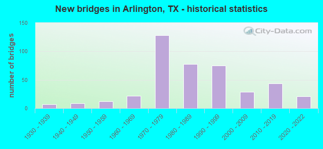
- New bridges - historical statistics
- 11920-1929
- 71930-1939
- 91940-1949
- 121950-1959
- 221960-1969
- 1281970-1979
- 781980-1989
- 751990-1999
- 292000-2009
- 442010-2019
- 212020-2022
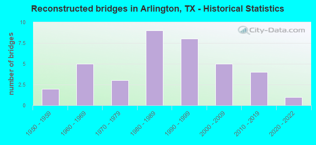
- Reconstructed bridges - Historical Statistics
- 21950-1959
- 51960-1969
- 31970-1979
- 91980-1989
- 81990-1999
- 52000-2009
- 42010-2019
- 12020-2022
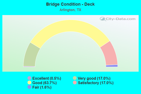
- Bridge Condition - Deck
- 0.5%Excellent
- 17.0%Very good
- 63.7%Good
- 17.0%Satisfactory
- 1.6%Fair
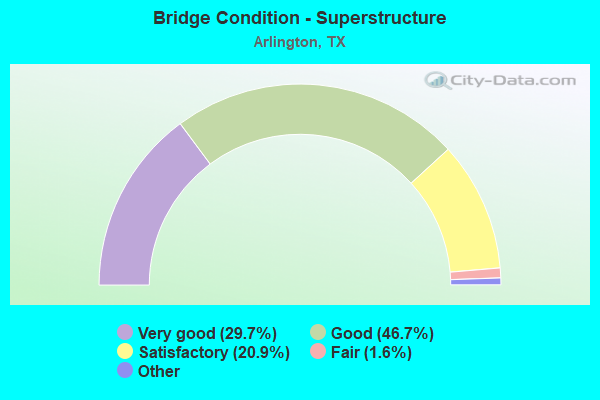
- Bridge Condition - Superstructure
- 29.7%Excellent
- 46.7%Very good
- 20.9%Good
- 1.6%Satisfactory
- 1.1%Fair
- 0.5%Poor
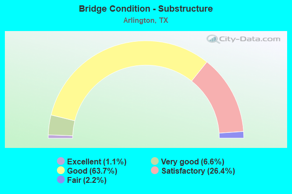
- Bridge Condition - Substructure
- 1.1%Excellent
- 6.6%Very good
- 63.7%Good
- 26.4%Satisfactory
- 2.2%Fair
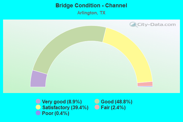
- Bridge Condition - Channel
- 8.9%Very good
- 48.8%Good
- 39.4%Satisfactory
- 2.4%Fair
- 0.4%Poor
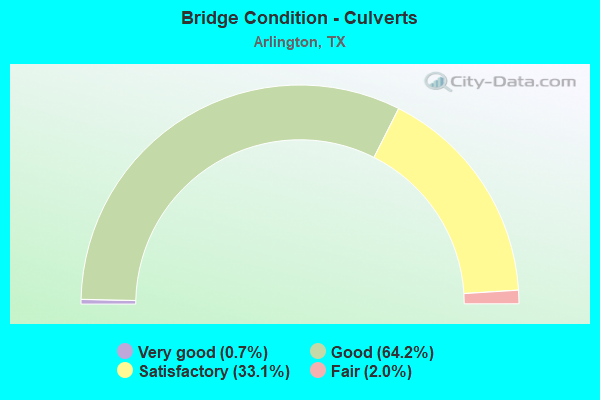
- Bridge Condition - Culverts
- 0.7%Very good
- 64.2%Good
- 33.1%Satisfactory
- 2.0%Fair
Find on map >> Show street view
Structure Number: 22200C06700001, Location: 0.5 MI S OF IH30 (Lat: 32.752639, Lng: -97.128544), Route carried "on" structure: City street , Year Built: 1960, Status: Open, Structure Length: 0.76m (2.49ft), Average Daily Traffic: 11,300 (year 2009), Average Future Daily Traffic: 11,350 (year 2029), Features Intersected: TRIB. TO VILLAGE CREEK, Facility Carried by Structure: WOODLAND DRIVE
Minimum Vertical Clearance: 30+ m (98+ ft), Kilometerpoint: 0.161, Lanes on structure: 2, Owner: City or Municipal Highway Agency, Approaching Roadway Width: 9.1m (29.9ft), Skew: 2 degrees, Material/Design: Concrete, Design/Construction: Culvert, Number Of Spans In Main Unit: 3, Length of Maximum Span: 2.1m (6.9ft), Curb or Sidewalk Widths: Left: 1.5m (4.9ft), Right: 1.4m (4.6ft), Curb-To-Curb Width: 9.1m (29.9ft), Out-to-Out Width: 12.3m (40.4ft)
Condition: Channel: Satisfactory, Culverts: Satisfactory, Operating Rating: 32.7 metric tons, Method Used To Determine Operating Rating: Field evaluation and documented engineering judgment, Inventory Rating: 24.5 metric tons, Method Used To Determine Inventory Rating: Field evaluation and documented engineering judgment, Structural Evaluation: Equal to present minimum criteria, Deck Geometry: High priority of corrective action, Waterway Adequacy: Better than present minimum criteria, Approach Roadway Alignment: Equal to present desirable criteria, Length Of Structure Improvement: 0.70m (2.30ft), Designated Inspection Frequency: Every 24 months, Inspection Date: October 2021, Bridge Improvement Cost: $1,000, Total Project Cost: $1,000, Deck Structure Type: Concrete Cast-file-Place, Wearing Surface/Protective System: Wearing Surface: Bituminous
Find on map >> Show street view
Structure Number: 22200C06721001, Location: 0.2 MI W OF PARK SPRINGS (Lat: 32.714011, Lng: -97.172686), Route carried "on" structure: City street , Year Built: 1962, Status: Open, Structure Length: 6.19m (20.31ft), Average Daily Traffic: 1,906 (year 2020), Truck Traffic: 10%, Average Future Daily Traffic: 3,920 (year 2029), Features Intersected: RUSH CREEK, Facility Carried by Structure: WOODLAND PARK BLVD
Minimum Vertical Clearance: 30+ m (98+ ft), Kilometerpoint: 0.241, Lanes on structure: 2, Owner: City or Municipal Highway Agency, Approaching Roadway Width: 13.6m (44.6ft), Material/Design: Concrete, Design/Construction: Stringer/Multi-beam, Number Of Spans In Main Unit: 5, Length of Maximum Span: 12.5m (41.0ft), Curb or Sidewalk Widths: Left: 1.1m (3.6ft), Right: 1.1m (3.6ft), Curb-To-Curb Width: 13.6m (44.6ft), Out-to-Out Width: 16.8m (55.1ft)
Condition: Deck: Good, Superstructure: Satisfactory, Substructure: Satisfactory, Channel: Good, Operating Rating: 40.8 metric tons, Method Used To Determine Operating Rating: Load Factor (LF), Inventory Rating: 24.5 metric tons, Method Used To Determine Inventory Rating: Load Factor (LF), Structural Evaluation: Equal to present minimum criteria, Deck Geometry: Superior to present desirable criteria, Waterway Adequacy: Better than present minimum criteria, Approach Roadway Alignment: Equal to present desirable criteria, Designated Inspection Frequency: Every 24 months, Inspection Date: October 2021, Deck Structure Type: Concrete Cast-file-Place, Wearing Surface/Protective System: Wearing Surface: Bituminous
Find on map >> Show street view
Structure Number: 22200C06755001, Location: 1.4 MI S OF SPUR 303 (Lat: 32.697792, Lng: -97.174814), Route carried "on" structure: City street , Year Built: 1972, Status: Open, Structure Length: 0.67m (2.20ft), Average Daily Traffic: 5,262 (year 2019), Average Future Daily Traffic: 6,560 (year 2029), Features Intersected: BRANCH OF RUSH CREEK, Facility Carried by Structure: WOODSIDE DR
Minimum Vertical Clearance: 30+ m (98+ ft), Kilometerpoint: 0.402, Lanes on structure: 2, Owner: City or Municipal Highway Agency, Approaching Roadway Width: 13.0m (42.7ft), Skew: 3 degrees, Material/Design: Concrete, Design/Construction: Culvert, Number Of Spans In Main Unit: 2, Length of Maximum Span: 2.7m (8.9ft), Curb or Sidewalk Widths: Left: 1.7m (5.6ft), Right: 1.2m (3.9ft), Curb-To-Curb Width: 13.0m (42.7ft), Out-to-Out Width: 21.9m (71.9ft)
Condition: Channel: Satisfactory, Culverts: Good, Operating Rating: 32.7 metric tons, Method Used To Determine Operating Rating: Field evaluation and documented engineering judgment, Inventory Rating: 24.5 metric tons, Method Used To Determine Inventory Rating: Field evaluation and documented engineering judgment, Structural Evaluation: Equal to present minimum criteria, Deck Geometry: Somewhat better than minimum adequacy, Waterway Adequacy: Better than present minimum criteria, Approach Roadway Alignment: Equal to present desirable criteria, Designated Inspection Frequency: Every 24 months, Inspection Date: October 2021, Deck Structure Type: Concrete Cast-file-Place, Wearing Surface/Protective System: Wearing Surface: Bituminous
Find on map >> Show street view
Structure Number: 22200C06755002, Location: N OF PLEASANT RIDGE ROAD (Lat: 32.682831, Lng: -97.177553), Route carried "on" structure: City street , Year Built: 1984, Status: Open, Structure Length: 2.99m (9.81ft), Average Daily Traffic: 8,101 (year 2019), Truck Traffic: 20%, Average Future Daily Traffic: 9,120 (year 2029), Design Load: HS 20, Features Intersected: KEE BRANCH, Facility Carried by Structure: WOODSIDE DRIVE
Minimum Vertical Clearance: 30+ m (98+ ft), Kilometerpoint: 1.931, Lanes on structure: 5, Owner: City or Municipal Highway Agency, Approaching Roadway Width: 18.3m (60.0ft), Skew: 2 degrees, Material/Design: Concrete, Design/Construction: Stringer/Multi-beam, Number Of Spans In Main Unit: 3, Length of Maximum Span: 10.1m (33.1ft), Curb or Sidewalk Widths: Left: 2.2m (7.2ft), Right: 0.0m, Curb-To-Curb Width: 18.2m (59.7ft), Out-to-Out Width: 21.4m (70.2ft)
Condition: Deck: Good, Superstructure: Good, Substructure: Good, Channel: Satisfactory, Operating Rating: 54.4 metric tons, Method Used To Determine Operating Rating: Assigned rating based on Load Factor Design (LFD) reported in metric tons, Inventory Rating: 32.7 metric tons, Method Used To Determine Inventory Rating: Assigned rating based on Load Factor Design (LFD) reported in metric tons, Structural Evaluation: Better than present minimum criteria, Deck Geometry: High priority of replacement, Waterway Adequacy: Better than present minimum criteria, Approach Roadway Alignment: Equal to present desirable criteria, Length Of Structure Improvement: 2.77m (9.09ft), Designated Inspection Frequency: Every 24 months, Inspection Date: October 2021, Bridge Improvement Cost: $11,000, Roadway Improvement Cost: $3,000, Total Project Cost: $14,000, Deck Structure Type: Concrete Cast-file-Place
Find on map >> Show street view
Structure Number: 22200C06792001, Location: .4 MI OF GREEN OAKS (Lat: 32.663583, Lng: -97.104286), Route carried "on" structure: City street , Year Built: 1986, Status: Open, Structure Length: 1.04m (3.41ft), Average Daily Traffic: 50 (year 2009), Truck Traffic: 1%, Average Future Daily Traffic: 100 (year 2029), Features Intersected: TRIB. TO FISH CREEK, Facility Carried by Structure: YAUPON DRIVE
Minimum Vertical Clearance: 30+ m (98+ ft), Kilometerpoint: 0.023, Lanes on structure: 2, Owner: City or Municipal Highway Agency, Approaching Roadway Width: 10.4m (34.1ft), Material/Design: Concrete, Design/Construction: Culvert, Number Of Spans In Main Unit: 4, Length of Maximum Span: 2.4m (7.9ft), Curb or Sidewalk Widths: Left: 1.8m (5.9ft), Right: 1.8m (5.9ft), Curb-To-Curb Width: 10.3m (33.8ft), Out-to-Out Width: 18.5m (60.7ft)
Condition: Channel: Good, Culverts: Satisfactory, Operating Rating: 32.7 metric tons, Method Used To Determine Operating Rating: Field evaluation and documented engineering judgment, Inventory Rating: 24.5 metric tons, Method Used To Determine Inventory Rating: Field evaluation and documented engineering judgment, Structural Evaluation: Equal to present minimum criteria, Deck Geometry: Superior to present desirable criteria, Waterway Adequacy: Better than present minimum criteria, Approach Roadway Alignment: Equal to present desirable criteria, Designated Inspection Frequency: Every 24 months, Inspection Date: October 2021, Deck Structure Type: Concrete Cast-file-Place, Wearing Surface/Protective System: Wearing Surface: Monolithic Concrete
Find on map >> Show street view
Structure Number: 22200C06792002, Location: 25 FT. N. OF NATHAN LOWE (Lat: 32.653522, Lng: -97.107819), Route carried "on" structure: City street , Year Built: 1983, Status: Open, Structure Length: 0.67m (2.20ft), Average Daily Traffic: 1,690 (year 2009), Truck Traffic: 1%, Average Future Daily Traffic: 1,740 (year 2029), Design Load: HS 20, Features Intersected: TRIB. TO FISH CREEK, Facility Carried by Structure: YAUPON DRIVE
Minimum Vertical Clearance: 30+ m (98+ ft), Kilometerpoint: 1.212, Lanes on structure: 2, Owner: City or Municipal Highway Agency, Approaching Roadway Width: 11.3m (37.1ft), Material/Design: Concrete, Design/Construction: Culvert, Number Of Spans In Main Unit: 3, Length of Maximum Span: 2.1m (6.9ft), Curb or Sidewalk Widths: Left: 1.2m (3.9ft), Right: 2.7m (8.9ft), Curb-To-Curb Width: 11.2m (36.7ft), Out-to-Out Width: 17.9m (58.7ft)
Condition: Channel: Good, Culverts: Good, Operating Rating: 44.4 metric tons, Method Used To Determine Operating Rating: No rating analysis performed, Inventory Rating: 32.7 metric tons, Method Used To Determine Inventory Rating: No rating analysis performed, Structural Evaluation: Better than present minimum criteria, Deck Geometry: Equal to present minimum criteria, Waterway Adequacy: Better than present minimum criteria, Approach Roadway Alignment: Equal to present desirable criteria, Designated Inspection Frequency: Every 24 months, Inspection Date: October 2021, Deck Structure Type: Concrete Cast-file-Place, Wearing Surface/Protective System: Wearing Surface: Monolithic Concrete
Find on map >> Show street view
Structure Number: 22200C07031002, Location: .1 MI E OF US 287 (Lat: 32.653656, Lng: -97.188764), Route carried "on" structure: City street , Year Built: 1999, Status: Open, Structure Length: 0.82m (2.69ft), Average Daily Traffic: 586 (year 2019), Average Future Daily Traffic: 100 (year 2029), Design Load: HS 20, Features Intersected: TRIB TO KEE BRANCH, Facility Carried by Structure: LONGHORN LANE
Minimum Vertical Clearance: 30+ m (98+ ft), Kilometerpoint: 0.048, Lanes on structure: 2, Owner: City or Municipal Highway Agency, Approaching Roadway Width: 11.4m (37.4ft), Skew: 20 degrees, Material/Design: Concrete, Design/Construction: Culvert, Number Of Spans In Main Unit: 4, Length of Maximum Span: 1.8m (5.9ft), Curb or Sidewalk Widths: Left: 3.2m (10.5ft), Right: 3.2m (10.5ft), Curb-To-Curb Width: 11.4m (37.4ft), Out-to-Out Width: 18.3m (60.0ft)
Condition: Channel: Good, Culverts: Satisfactory, Operating Rating: 44.4 metric tons, Method Used To Determine Operating Rating: Assigned rating based on Load Factor Design (LFD) reported in metric tons, Inventory Rating: 32.7 metric tons, Method Used To Determine Inventory Rating: Assigned rating based on Load Factor Design (LFD) reported in metric tons, Structural Evaluation: Equal to present minimum criteria, Deck Geometry: Better than present minimum criteria, Waterway Adequacy: Better than present minimum criteria, Approach Roadway Alignment: Equal to present desirable criteria, Designated Inspection Frequency: Every 24 months, Inspection Date: October 2021, Deck Structure Type: Concrete Cast-file-Place, Wearing Surface/Protective System: Wearing Surface: Bituminous
Find on map >> Show street view
Structure Number: 22200C07071001, Location: 0.35 MI W OF MATLOCK ROAD (Lat: 32.668247, Lng: -97.121264), Route carried "on" structure: City street , Year Built: 1986, Status: Open, Structure Length: 0.79m (2.59ft), Average Daily Traffic: 895 (year 2019), Average Future Daily Traffic: 1,000 (year 2029), Design Load: HS 20, Features Intersected: FISH CREEK, Facility Carried by Structure: EMBERCREST DRIVE W
Minimum Vertical Clearance: 30+ m (98+ ft), Kilometerpoint: 0.805, Lanes on structure: 2, Owner: City or Municipal Highway Agency, Approaching Roadway Width: 11.3m (37.1ft), Material/Design: Concrete, Design/Construction: Culvert, Number Of Spans In Main Unit: 4, Length of Maximum Span: 1.8m (5.9ft)
Condition: Channel: Good, Culverts: Satisfactory, Operating Rating: 44.4 metric tons, Method Used To Determine Operating Rating: No rating analysis performed, Inventory Rating: 32.7 metric tons, Method Used To Determine Inventory Rating: No rating analysis performed, Structural Evaluation: Equal to present minimum criteria, Waterway Adequacy: Better than present minimum criteria, Approach Roadway Alignment: Equal to present desirable criteria, Designated Inspection Frequency: Every 24 months, Inspection Date: October 2021
Find on map >> Show street view
Structure Number: 22200C08953001, Location: 0.5 MI N OF IH 20 (Lat: 32.674192, Lng: -97.231731), Route carried "on" structure: City street , Year Built: 1987, Status: Open, Structure Length: 5.49m (18.01ft), Average Daily Traffic: 50 (year 2009), Average Future Daily Traffic: 100 (year 2029), Design Load: HS 20, Features Intersected: VILLAGE CK-LK ARLINGTON, Facility Carried by Structure: TREASURE ISLAND
Minimum Vertical Clearance: 30+ m (98+ ft), Kilometerpoint: 0.161, Lanes on structure: 2, Owner: City or Municipal Highway Agency, Approaching Roadway Width: 12.5m (41.0ft), Skew: 3 degrees, Material/Design: Prestressed concrete, Design/Construction: Stringer/Multi-beam, Number Of Spans In Main Unit: 2, Length of Maximum Span: 27.4m (89.9ft), Curb or Sidewalk Widths: Left: 0.9m (3.0ft), Right: 0.9m (3.0ft), Curb-To-Curb Width: 13.3m (43.6ft), Out-to-Out Width: 15.6m (51.2ft)
Condition: Deck: Satisfactory, Superstructure: Good, Substructure: Satisfactory, Channel: Satisfactory, Operating Rating: 54.4 metric tons, Method Used To Determine Operating Rating: Assigned rating based on Load Factor Design (LFD) reported in metric tons, Inventory Rating: 32.7 metric tons, Method Used To Determine Inventory Rating: Assigned rating based on Load Factor Design (LFD) reported in metric tons, Structural Evaluation: Equal to present minimum criteria, Deck Geometry: Superior to present desirable criteria, Waterway Adequacy: Better than present minimum criteria, Approach Roadway Alignment: Equal to present desirable criteria, Designated Inspection Frequency: Every 24 months, Inspection Date: October 2021, Deck Structure Type: Concrete Cast-file-Place
Find on map >> Show street view
Structure Number: 22200C08953002, Location: 0.1 MI N OF IH 20 (Lat: 32.670728, Lng: -97.229836), Route carried "on" structure: City street , Year Built: 1987, Status: Open, Structure Length: 7.32m (24.02ft), Average Daily Traffic: 1,155 (year 2019), Average Future Daily Traffic: 100 (year 2029), Design Load: HS 20, Features Intersected: VILLAGE CK-LK ARLINGTON, Facility Carried by Structure: TREASURE ISLAND
Minimum Vertical Clearance: 30+ m (98+ ft), Kilometerpoint: 0.805, Lanes on structure: 2, Owner: City or Municipal Highway Agency, Approaching Roadway Width: 13.3m (43.6ft), Material/Design: Prestressed concrete, Design/Construction: Stringer/Multi-beam, Number Of Spans In Main Unit: 3, Length of Maximum Span: 24.4m (80.1ft), Curb or Sidewalk Widths: Left: 0.9m (3.0ft), Right: 0.9m (3.0ft), Curb-To-Curb Width: 13.3m (43.6ft), Out-to-Out Width: 15.6m (51.2ft)
Condition: Deck: Good, Superstructure: Very good, Substructure: Good, Channel: Satisfactory, Operating Rating: 54.4 metric tons, Method Used To Determine Operating Rating: Assigned rating based on Load Factor Design (LFD) reported in metric tons, Inventory Rating: 32.7 metric tons, Method Used To Determine Inventory Rating: Assigned rating based on Load Factor Design (LFD) reported in metric tons, Structural Evaluation: Better than present minimum criteria, Deck Geometry: Better than present minimum criteria, Waterway Adequacy: Better than present minimum criteria, Approach Roadway Alignment: Equal to present desirable criteria, Designated Inspection Frequency: Every 24 months, Inspection Date: October 2021, Deck Structure Type: Concrete Cast-file-Place
Find on map >> Show street view
Structure Number: 22200C09300001, Location: 0.27 MI S OF W SUBLETT RD (Lat: 32.644522, Lng: -97.141683), Route carried "on" structure: City street , Year Built: 1990, Status: Open, Structure Length: 1.01m (3.31ft), Average Daily Traffic: 1,000 (year 2016), Truck Traffic: 1%, Average Future Daily Traffic: 1,500 (year 2036), Features Intersected: RUSH CREEK TRIBUTARY, Facility Carried by Structure: FOX HUNT DR
Minimum Vertical Clearance: 30+ m (98+ ft), Kilometerpoint: 0.000, Lanes on structure: 2, Owner: City or Municipal Highway Agency, Approaching Roadway Width: 11.4m (37.4ft), Material/Design: Concrete, Design/Construction: Culvert, Number Of Spans In Main Unit: 3, Length of Maximum Span: 3.0m (9.8ft), Curb or Sidewalk Widths: Left: 1.2m (3.9ft), Right: 1.2m (3.9ft), Curb-To-Curb Width: 11.4m (37.4ft), Out-to-Out Width: 21.4m (70.2ft)
Condition: Channel: Good, Culverts: Good, Operating Rating: 32.7 metric tons, Method Used To Determine Operating Rating: Field evaluation and documented engineering judgment, Inventory Rating: 24.5 metric tons, Method Used To Determine Inventory Rating: Field evaluation and documented engineering judgment, Structural Evaluation: Equal to present minimum criteria, Deck Geometry: Better than present minimum criteria, Waterway Adequacy: Superior to present desirable criteria, Approach Roadway Alignment: Better than present minimum criteria, Designated Inspection Frequency: Every 24 months, Inspection Date: October 2021, Deck Structure Type: Concrete Cast-file-Place, Wearing Surface/Protective System: Wearing Surface: Monolithic Concrete
Find on map >> Show street view
Structure Number: 22200C10000001, Location: 500 FT S. IH 20 FRT. RD. (Lat: 32.675106, Lng: -97.093692), Route carried "on" structure: City street , Year Built: 1995, Status: Open, Structure Length: 1.28m (4.20ft), Average Daily Traffic: 50 (year 2009), Truck Traffic: 1%, Average Future Daily Traffic: 100 (year 2029), Design Load: HS 20, Features Intersected: TRIB TO FISH CREEK, Facility Carried by Structure: MCDONALD'S ACCESS
Minimum Vertical Clearance: 30+ m (98+ ft), Kilometerpoint: 0.153, Lanes on structure: 2, Owner: City or Municipal Highway Agency, Approaching Roadway Width: 7.3m (24.0ft), Material/Design: Concrete, Design/Construction: Culvert, Number Of Spans In Main Unit: 4, Length of Maximum Span: 3.0m (9.8ft), Curb-To-Curb Width: 7.2m (23.6ft), Out-to-Out Width: 8.3m (27.2ft)
Condition: Channel: Good, Culverts: Good, Operating Rating: 44.4 metric tons, Method Used To Determine Operating Rating: No rating analysis performed, Inventory Rating: 32.7 metric tons, Method Used To Determine Inventory Rating: No rating analysis performed, Structural Evaluation: Better than present minimum criteria, Deck Geometry: Somewhat better than minimum adequacy, Waterway Adequacy: Better than present minimum criteria, Approach Roadway Alignment: Equal to present desirable criteria, Designated Inspection Frequency: Every 24 months, Inspection Date: October 2021, Deck Structure Type: Concrete Cast-file-Place, Wearing Surface/Protective System: Wearing Surface: Monolithic Concrete
Find on map >> Show street view
Structure Number: 22200C10005001, Location: .15 MI N OF EDEN RD (Lat: 32.635511, Lng: -97.099506), Route carried "on" structure: City street , Year Built: 2003, Status: Open, Structure Length: 0.94m (3.08ft), Average Daily Traffic: 180 (year 2019), Average Future Daily Traffic: 100 (year 2029), Design Load: HS 20, Features Intersected: TRIB TO LYNN CREEK, Facility Carried by Structure: SNAPDRAGON LANE
Minimum Vertical Clearance: 30+ m (98+ ft), Kilometerpoint: 0.045, Lanes on structure: 2, Owner: City or Municipal Highway Agency, Approaching Roadway Width: 8.2m (26.9ft), Skew: 1 degrees, Material/Design: Concrete, Design/Construction: Culvert, Number Of Spans In Main Unit: 4, Length of Maximum Span: 2.1m (6.9ft), Curb or Sidewalk Widths: Left: 1.2m (3.9ft), Right: 1.2m (3.9ft), Curb-To-Curb Width: 8.2m (26.9ft), Out-to-Out Width: 15.2m (49.9ft)
Condition: Channel: Good, Culverts: Good, Operating Rating: 44.4 metric tons, Method Used To Determine Operating Rating: Assigned rating based on Load Factor Design (LFD) reported in metric tons, Inventory Rating: 32.7 metric tons, Method Used To Determine Inventory Rating: Assigned rating based on Load Factor Design (LFD) reported in metric tons, Structural Evaluation: Better than present minimum criteria, Deck Geometry: Somewhat better than minimum adequacy, Waterway Adequacy: Better than present minimum criteria, Approach Roadway Alignment: Equal to present desirable criteria, Designated Inspection Frequency: Every 24 months, Inspection Date: October 2021, Deck Structure Type: Concrete Cast-file-Place, Wearing Surface/Protective System: Wearing Surface: Monolithic Concrete
Find on map >> Show street view
Structure Number: 22200C10010001, Location: .1 MI N OF PULMERIA DR (Lat: 32.635486, Lng: -97.098472), Route carried "on" structure: City street , Year Built: 2003, Status: Open, Structure Length: 0.94m (3.08ft), Average Daily Traffic: 50 (year 2009), Average Future Daily Traffic: 100 (year 2029), Design Load: HS 20, Features Intersected: TRIB TO LYNN CREEK, Facility Carried by Structure: WATERLILLY DR
Minimum Vertical Clearance: 30+ m (98+ ft), Kilometerpoint: 0.063, Lanes on structure: 2, Owner: City or Municipal Highway Agency, Approaching Roadway Width: 8.2m (26.9ft), Skew: 1 degrees, Material/Design: Concrete, Design/Construction: Culvert, Number Of Spans In Main Unit: 4, Length of Maximum Span: 2.1m (6.9ft), Curb or Sidewalk Widths: Left: 1.2m (3.9ft), Right: 1.2m (3.9ft), Curb-To-Curb Width: 8.2m (26.9ft), Out-to-Out Width: 15.2m (49.9ft)
Condition: Channel: Good, Culverts: Good, Operating Rating: 44.4 metric tons, Method Used To Determine Operating Rating: Assigned rating based on Load Factor Design (LFD) reported in metric tons, Inventory Rating: 32.7 metric tons, Method Used To Determine Inventory Rating: Assigned rating based on Load Factor Design (LFD) reported in metric tons, Structural Evaluation: Better than present minimum criteria, Deck Geometry: Equal to present minimum criteria, Waterway Adequacy: Better than present minimum criteria, Approach Roadway Alignment: Equal to present desirable criteria, Designated Inspection Frequency: Every 24 months, Inspection Date: October 2021, Deck Structure Type: Concrete Cast-file-Place, Wearing Surface/Protective System: Wearing Surface: Monolithic Concrete
Find on map >> Show street view
Structure Number: 22200C10015001, Location: .6 MI W OF FM 157 (Lat: 32.746183, Lng: -97.087936), Route carried "on" structure: City street , Year Built: 2009, Status: Open, Structure Length: 20.97m (68.80ft), Average Daily Traffic: 50 (year 2009), Truck Traffic: 1%, Average Future Daily Traffic: 100 (year 2029), Design Load: HL 93, Features Intersected: JOHNSON CREEK, Facility Carried by Structure: COWBOYS WAY
Minimum Vertical Clearance: 30+ m (98+ ft), Kilometerpoint: 0.966, Lanes on structure: 5, Owner: City or Municipal Highway Agency, Approaching Roadway Width: 17.1m (56.1ft), Skew: 4 degrees, Material/Design: Prestressed concrete, Design/Construction: Stringer/Multi-beam, Number Of Spans In Main Unit: 4, Number Of Approach Spans: 3, Length of Maximum Span: 35.1m (115.2ft), Curb or Sidewalk Widths: Left: 4.9m (16.1ft), Right: 3.4m (11.2ft), Curb-To-Curb Width: 17.1m (56.1ft), Out-to-Out Width: 25.3m (83.0ft)
Condition: Deck: Good, Superstructure: Very good, Substructure: Good, Channel: Good, Operating Rating: 54.4 metric tons, Method Used To Determine Operating Rating: Assigned ratings based on Load and Resistance Factor Design (LRFD) reported in metric tons, Inventory Rating: 32.7 metric tons, Method Used To Determine Inventory Rating: Assigned ratings based on Load and Resistance Factor Design (LRFD) reported in metric tons, Structural Evaluation: Better than present minimum criteria, Deck Geometry: High priority of replacement, Waterway Adequacy: Equal to present desirable criteria, Approach Roadway Alignment: Equal to present desirable criteria, Designated Inspection Frequency: Every 24 months, Inspection Date: October 2021, Deck Structure Type: Concrete Cast-file-Place, Wearing Surface/Protective System: Membrane: Other, Deck Protection: Epoxy Coated Reinforcing
Find on map >> Show street view
Structure Number: 22200000807292, Location: 6.1 MI. FROM JCT. IH 820 (Lat: 32.736428, Lng: -97.131567), Route carried "under" structure: State highway 180, Year Built: 1977, Structure Length: 0. m, Average Daily Traffic: 17,280 (year 2013), Truck Traffic: 5%, Features Intersected: SH 180, Facility Carried by Structure: FIELDER ROAD
Minimum Vertical Clearance: 6.91m (22.67ft), Kilometerpoint: 40.330, Lanes on structure: 4, Lanes under structure: 9, Material/Design: Prestressed concrete, Design/Construction: Stringer/Multi-beam, Length of Maximum Span: 35.4m (116.1ft)
Find on map >> Show street view
Structure Number: 22200000807444, Location: 2.0 MI E OF FM 157 (Lat: 32.743433, Lng: -97.062511), Route carried "under" structure: State highway 360, Year Built: 2010, Structure Length: 0. m, Average Daily Traffic: 166,940 (year 2013), Truck Traffic: 5%, Features Intersected: SH 360, Facility Carried by Structure: SH 180 WBML
Minimum Vertical Clearance: 5.44m (17.85ft), Kilometerpoint: 20.163, Lanes on structure: 3, Lanes under structure: 13, Material/Design: Prestressed concrete, Design/Construction: Stringer/Multi-beam, Length of Maximum Span: 36.6m (120.1ft)
Find on map >> Show street view
Structure Number: 22200000807445, Location: 2.0 MI E OF FM 157 (Lat: 32.743347, Lng: -97.062511), Route carried "under" structure: State highway 360, Year Built: 2010, Structure Length: 0. m, Average Daily Traffic: 166,940 (year 2013), Truck Traffic: 5%, Features Intersected: SH 360, Facility Carried by Structure: SH 180 EBML
Minimum Vertical Clearance: 5.23m (17.16ft), Kilometerpoint: 20.163, Lanes on structure: 3, Lanes under structure: 13, Material/Design: Prestressed concrete, Design/Construction: Stringer/Multi-beam, Length of Maximum Span: 36.6m (120.1ft)
Find on map >> Show street view
Structure Number: 22200017209126, Location: 0.30 MI S OF IH 20 (Lat: 32.668161, Lng: -97.204200), Route carried "under" structure: City street , Year Built: 1973, Structure Length: 0. m, Average Daily Traffic: 27,500 (year 2009), Features Intersected: KENN-LITTLE SCHL RD, Facility Carried by Structure: US 287 NB
Minimum Vertical Clearance: 4.83m (15.85ft), Kilometerpoint: 0.000, Lanes on structure: 2, Lanes under structure: 7, Material/Design: Prestressed concrete, Design/Construction: Stringer/Multi-beam, Length of Maximum Span: 22.9m (75.1ft)
Find on map >> Show street view
Structure Number: 22200017209127, Location: 0.30 MI S OF IH 20 (Lat: 32.667511, Lng: -97.204700), Route carried "under" structure: City street , Year Built: 1973, Structure Length: 0. m, Average Daily Traffic: 27,500 (year 2009), Features Intersected: KENN-LITTLE SCHL RD, Facility Carried by Structure: US 287 SB
Minimum Vertical Clearance: 5.13m (16.83ft), Kilometerpoint: 0.000, Lanes on structure: 3, Lanes under structure: 7, Material/Design: Prestressed concrete, Design/Construction: Stringer/Multi-beam, Length of Maximum Span: 25.3m (83.0ft)
Find on map >> Show street view
Structure Number: 22200017209134, Location: 4.0 MI N OF FM 157 (Lat: 32.646269, Lng: -97.185125), Route carried "under" structure: City street , Year Built: 1973, Structure Length: 0. m, Average Daily Traffic: 16,710 (year 2009), Features Intersected: KENN-SUBLETT RD, Facility Carried by Structure: US 287 NB
Minimum Vertical Clearance: 5.08m (16.67ft), Kilometerpoint: 2.013, Lanes on structure: 2, Lanes under structure: 6, Material/Design: Prestressed concrete, Design/Construction: Stringer/Multi-beam, Length of Maximum Span: 36.6m (120.1ft)
Find on map >> Show street view
Structure Number: 22200017209135, Location: 4.0 MI N OF FM 157 (Lat: 32.646258, Lng: -97.185228), Route carried "under" structure: City street , Year Built: 1973, Structure Length: 0. m, Average Daily Traffic: 16,710 (year 2009), Features Intersected: KENN-SUBLETT RD, Facility Carried by Structure: US 287 SB
Minimum Vertical Clearance: 5.28m (17.32ft), Kilometerpoint: 2.013, Lanes on structure: 2, Lanes under structure: 6, Material/Design: Prestressed concrete, Design/Construction: Stringer/Multi-beam, Length of Maximum Span: 36.6m (120.1ft)
Find on map >> Show street view
Structure Number: 22200017209136, Location: 3.0 MI N OF FM 157 (Lat: 32.633436, Lng: -97.176489), Route carried "under" structure: City street , Year Built: 1973, Structure Length: 0. m, Average Daily Traffic: 3,290 (year 2009), Features Intersected: EDEN RD, Facility Carried by Structure: US 287 NB
Minimum Vertical Clearance: 5.64m (18.50ft), Kilometerpoint: 0.000, Lanes on structure: 2, Lanes under structure: 4, Material/Design: Prestressed concrete, Design/Construction: Stringer/Multi-beam, Length of Maximum Span: 32.9m (107.9ft)
Find on map >> Show street view
Structure Number: 22200017209137, Location: 3.0 MI N OF FM 157 (Lat: 32.633414, Lng: -97.176594), Route carried "under" structure: City street , Year Built: 1973, Structure Length: 0. m, Average Daily Traffic: 3,290 (year 2009), Features Intersected: EDEN RD, Facility Carried by Structure: US 287 SB
Minimum Vertical Clearance: 5.11m (16.77ft), Kilometerpoint: 0.000, Lanes on structure: 2, Lanes under structure: 4, Material/Design: Prestressed concrete, Design/Construction: Stringer/Multi-beam, Length of Maximum Span: 32.9m (107.9ft)
Find on map >> Show street view
Structure Number: 22200017209139, Location: 2.45 MI N OF FM 157 (Lat: 32.626475, Lng: -97.171233), Route carried "under" structure: US 287, Year Built: 1973, Structure Length: 0. m, Average Daily Traffic: 59,680 (year 2013), Truck Traffic: 10%, Features Intersected: US 287, Facility Carried by Structure: RUSSELL CURRY RD
Minimum Vertical Clearance: 5.46m (17.91ft), Kilometerpoint: 38.996, Lanes on structure: 2, Lanes under structure: 4, Material/Design: Steel continuous, Design/Construction: Stringer/Multi-beam, Length of Maximum Span: 47.2m (154.9ft)
Find on map >> Show street view
Structure Number: 2220001720914, Location: 1.4 MI N OF FM 157 (Lat: 32.614033, Lng: -97.160819), Route carried "under" structure: City street , Year Built: 1973, Structure Length: 0. m, Average Daily Traffic: 4,980 (year 2009), Features Intersected: TURNER-WARNELL RD, Facility Carried by Structure: US 287 NB
Minimum Vertical Clearance: 5.05m (16.57ft), Kilometerpoint: 1.981, Lanes on structure: 2, Lanes under structure: 4, Material/Design: Prestressed concrete, Design/Construction: Stringer/Multi-beam, Length of Maximum Span: 32.9m (107.9ft)
Find on map >> Show street view
Structure Number: 22200017209141, Location: 1.4 MI N OF FM 157 (Lat: 32.614025, Lng: -97.160936), Route carried "under" structure: City street , Year Built: 1973, Structure Length: 0. m, Average Daily Traffic: 4,980 (year 2009), Features Intersected: TURNER-WARNELL RD, Facility Carried by Structure: US 287 SB
Minimum Vertical Clearance: 5.28m (17.32ft), Kilometerpoint: 1.981, Lanes on structure: 2, Lanes under structure: 4, Material/Design: Prestressed concrete, Design/Construction: Stringer/Multi-beam, Length of Maximum Span: 32.9m (107.9ft)
Find on map >> Show street view
Structure Number: 22200106802039, Location: 2.10 MI W OF FM 157 (Lat: 32.759700, Lng: -97.131639), Route carried "under" structure: Interstate 30, Year Built: 1957, Structure Length: 0. m, Average Daily Traffic: 133,730 (year 2013), Truck Traffic: 8%, Features Intersected: IH 30, Facility Carried by Structure: FIELDER ROAD SB
Minimum Vertical Clearance: 4.85m (15.91ft), Kilometerpoint: 40.654, Material/Design: Concrete continuous, Design/Construction: Tee Beam, Length of Maximum Span: 20.7m (67.9ft)
Find on map >> Show street view
Structure Number: 22200106802057, Location: 1.2 MI N OF US-80 (Lat: 32.759608, Lng: -97.062794), Route carried "under" structure: Interstate 30, Year Built: 1956, Structure Length: 0. m, Average Daily Traffic: 94,000 (year 2013), Truck Traffic: 8%, Features Intersected: IH-30, Facility Carried by Structure: SH360 NB FR/WATSON
Minimum Vertical Clearance: 4.52m (14.83ft), Kilometerpoint: 47.081, Material/Design: Steel continuous, Design/Construction: Stringer/Multi-beam, Length of Maximum Span: 24.4m (80.1ft)
Find on map >> Show street view
Structure Number: 22200106802058, Location: 0.3 MI E OF SH-360 (Lat: 32.759864, Lng: -97.057594), Route carried "under" structure: Interstate 30, Year Built: 1957, Structure Length: 0. m, Average Daily Traffic: 108,000 (year 2016), Truck Traffic: 9%, Features Intersected: IH 30 WB to SH 360
Minimum Vertical Clearance: 4.52m (14.83ft), Kilometerpoint: 47.592, Lanes on structure: 2, Lanes under structure: 7, Material/Design: Steel continuous, Design/Construction: Stringer/Multi-beam, Length of Maximum Span: 30.8m (101.0ft)
Find on map >> Show street view
Structure Number: 22200106802107, Location: 0.7 MI W OF SH 360 (Lat: 32.759653, Lng: -97.075956), Route carried "under" structure: Interstate 30, Year Built: 1993, Structure Length: 0. m, Average Daily Traffic: 143,240 (year 2013), Truck Traffic: 8%, Features Intersected: IH 30, Facility Carried by Structure: BALLPARK WAY
Minimum Vertical Clearance: 5.54m (18.18ft), Kilometerpoint: 45.861, Material/Design: Prestressed concrete, Design/Construction: Stringer/Multi-beam, Length of Maximum Span: 43.6m (143.0ft)
Find on map >> Show street view
Structure Number: 22200106802149, Location: 0.50 MI W OF DUNCAN PERRY (Lat: 32.759539, Lng: -97.045422), Route carried "under" structure: Interstate 30, Year Built: 1961, Structure Length: 0. m, Average Daily Traffic: 94,000 (year 2013), Truck Traffic: 8%, Features Intersected: IH 30, Facility Carried by Structure: GREAT SW PKWY
Minimum Vertical Clearance: 4.88m (16.01ft), Kilometerpoint: 48.704, Material/Design: Prestressed concrete, Design/Construction: Stringer/Multi-beam, Length of Maximum Span: 20.7m (67.9ft)
Find on map >> Show street view
Structure Number: 22200106802171, Location: 1.20 MI W OF FM 157 (Lat: 32.759819, Lng: -97.114489), Route carried "under" structure: Interstate 30, Year Built: 1987, Structure Length: 0. m, Average Daily Traffic: 133,730 (year 2013), Truck Traffic: 8%, Features Intersected: IH 30, Facility Carried by Structure: COOPER STREET
Minimum Vertical Clearance: 5.39m (17.68ft), Kilometerpoint: 42.261, Lanes on structure: 6, Lanes under structure: 9, Material/Design: Prestressed concrete, Design/Construction: Box Beam or Girders - Multiple, Length of Maximum Span: 31.1m (102.0ft)
Find on map >> Show street view
Structure Number: 22200106802174, Location: 2.10 MI W OF FM 157 (Lat: 32.759919, Lng: -97.131469), Route carried "under" structure: Interstate 30, Year Built: 1972, Structure Length: 0. m, Average Daily Traffic: 133,730 (year 2013), Truck Traffic: 8%, Features Intersected: IH 30, Facility Carried by Structure: FIELDER RD NB
Minimum Vertical Clearance: 4.78m (15.68ft), Kilometerpoint: 40.654, Material/Design: Steel continuous, Design/Construction: Stringer/Multi-beam, Length of Maximum Span: 20.7m (67.9ft)
Find on map >> Show street view
Structure Number: 22200106802192, Location: 1.60 MI W OF FM 157 (Lat: 32.759789, Lng: -97.123050), Route carried "under" structure: Interstate 30, Year Built: 1995, Structure Length: 0. m, Average Daily Traffic: 133,730 (year 2013), Truck Traffic: 8%, Features Intersected: IH 30, Facility Carried by Structure: DAVIS DRIVE
Minimum Vertical Clearance: 5.28m (17.32ft), Kilometerpoint: 41.458, Lanes on structure: 4, Lanes under structure: 7, Material/Design: Prestressed concrete, Design/Construction: Stringer/Multi-beam, Length of Maximum Span: 31.4m (103.0ft)
Find on map >> Show street view
Structure Number: 22200106802285, Location: 2.80 MI W OF FM 157 (Lat: 32.760217, Lng: -97.148642), Route carried "under" structure: City street 669, Year Built: 1997, Structure Length: 0. m, Average Daily Traffic: 15,220 (year 2009), Features Intersected: GREEN OAKS BVD/VILLGE CK, Facility Carried by Structure: IH 30 WB
Minimum Vertical Clearance: 6.61m (21.69ft), Kilometerpoint: 3.460, Lanes on structure: 3, Lanes under structure: 6, Material/Design: Prestressed concrete, Design/Construction: Stringer/Multi-beam, Length of Maximum Span: 33.2m (108.9ft)
Find on map >> Show street view
Structure Number: 22200106802286, Location: 2.80 MI W OF FM 157 (Lat: 32.759939, Lng: -97.150661), Route carried "under" structure: City street 8669, Year Built: 1997, Structure Length: 0. m, Average Daily Traffic: 15,220 (year 2009), Features Intersected: GREEN OAKS BVD/VILLGE CK, Facility Carried by Structure: IH 30 EB
Minimum Vertical Clearance: 6.61m (21.69ft), Kilometerpoint: 3.460, Material/Design: Prestressed concrete, Design/Construction: Stringer/Multi-beam, Length of Maximum Span: 33.2m (108.9ft)
Find on map >> Show street view
Structure Number: 22200106802485, Location: .25 MI W OF FM 157 (Lat: 32.760225, Lng: -97.101764), Route carried "under" structure: Interstate 30, Year Built: 2010, Structure Length: 0. m, Average Daily Traffic: 133,730 (year 2013), Truck Traffic: 8%, Features Intersected: IH-30, Facility Carried by Structure: NB CENTER ST
Minimum Vertical Clearance: 6.71m (22.01ft), Kilometerpoint: 0.198, Lanes on structure: 13, Material/Design: Prestressed concrete, Design/Construction: Stringer/Multi-beam, Length of Maximum Span: 28.0m (91.9ft)
Find on map >> Show street view
Structure Number: 22200106802486, Location: .250 MI W OF FM 157 (Lat: 32.760222, Lng: -97.102089), Route carried "under" structure: Interstate 30, Year Built: 2010, Structure Length: 0. m, Average Daily Traffic: 133,730 (year 2013), Truck Traffic: 8%, Features Intersected: IH-30, Facility Carried by Structure: SB CENTER ST
Minimum Vertical Clearance: 5.94m (19.49ft), Kilometerpoint: 0.198, Lanes on structure: 13, Material/Design: Prestressed concrete, Design/Construction: Stringer/Multi-beam, Length of Maximum Span: 28.0m (91.9ft)
Find on map >> Show street view
Structure Number: 22200106802487, Location: 2.0 Mi W of SH-360 (Lat: 32.759733, Lng: -97.097081), Route carried "under" structure: Interstate 30, Year Built: 2010, Structure Length: 0. m, Average Daily Traffic: 110,000 (year 2009), Truck Traffic: 9%, Features Intersected: IH-30, Facility Carried by Structure: FM-157 NB
Minimum Vertical Clearance: 7.67m (25.16ft), Kilometerpoint: 43.890, Lanes on structure: 12, Material/Design: Prestressed concrete, Design/Construction: Stringer/Multi-beam, Length of Maximum Span: 36.0m (118.1ft)
Find on map >> Show street view
Structure Number: 22200106802488, Location: 2.0 M W of SH-360 (Lat: 32.759772, Lng: -97.097156), Route carried "under" structure: Interstate 30, Year Built: 2010, Structure Length: 0. m, Average Daily Traffic: 110,000 (year 2009), Truck Traffic: 9%, Features Intersected: IH-30, Facility Carried by Structure: FM-157 SB
Minimum Vertical Clearance: 5.16m (16.93ft), Kilometerpoint: 43.890, Lanes on structure: 12, Material/Design: Prestressed concrete, Design/Construction: Stringer/Multi-beam, Length of Maximum Span: 36.0m (118.1ft)
Find on map >> Show street view
Structure Number: 22200106802489, Location: 0.1 MI W OF CENTER ST (Lat: 32.760456, Lng: -97.102872), Route carried "under" structure: Ramp State highway 30, Year Built: 2011, Structure Length: 0. m, Average Daily Traffic: 50 (year 2009), Features Intersected: IH 30 WB EXIT RAMP
Minimum Vertical Clearance: 5.11m (16.77ft), Kilometerpoint: 0.002, Lanes on structure: 2, Material/Design: Prestressed concrete, Design/Construction: Stringer/Multi-beam, Length of Maximum Span: 36.6m (120.1ft)
Find on map >> Show street view
Structure Number: 2220010680249, Location: 0.2 MI W OF BAIRD FARM RD (Lat: 32.760228, Lng: -97.089083), Route carried "under" structure: Ramp State highway 30, Year Built: 2011, Structure Length: 0. m, Average Daily Traffic: 50 (year 2009), Features Intersected: IH 30 WB EXIT RAMP
Minimum Vertical Clearance: 6.02m (19.75ft), Kilometerpoint: 0.002, Lanes on structure: 1, Material/Design: Prestressed concrete, Design/Construction: Stringer/Multi-beam, Length of Maximum Span: 32.0m (105.0ft)
Find on map >> Show street view
Structure Number: 22200106802491, Location: 0.2 MI E OF FM 157 (Lat: 32.759253, Lng: -97.093939), Route carried "under" structure: Ramp State highway 30, Year Built: 2011, Structure Length: 0. m, Average Daily Traffic: 50 (year 2009), Features Intersected: IH 30 EB EXIT RAMP
Minimum Vertical Clearance: 5.05m (16.57ft), Kilometerpoint: 0.002, Lanes on structure: 1, Material/Design: Prestressed concrete, Design/Construction: Stringer/Multi-beam, Length of Maximum Span: 34.7m (113.8ft)
Find on map >> Show street view
Structure Number: 22200106802492, Location: 1.2 MI W OF SH 360 (Lat: 32.759508, Lng: -97.085139), Route carried "under" structure: Interstate 30, Year Built: 2010, Structure Length: 0. m, Average Daily Traffic: 103,860 (year 2009), Truck Traffic: 10%, Features Intersected: IH 30, Facility Carried by Structure: BAIRD FARM ROAD
Minimum Vertical Clearance: 5.74m (18.83ft), Kilometerpoint: 0.002, Lanes on structure: 11, Material/Design: Steel, Design/Construction: Stringer/Multi-beam, Length of Maximum Span: 48.2m (158.1ft)
Find on map >> Show street view
Structure Number: 22200106802548, Location: 1.2 Mi. N. of SH 180 (Lat: 32.759511, Lng: -97.063250), Route carried "under" structure: Interstate 30, Year Built: 2021, Structure Length: 0. m, Average Daily Traffic: 122,378 (year 2020), Truck Traffic: 10%, Features Intersected: IH-30, Facility Carried by Structure: SH 360 NB
Minimum Vertical Clearance: 6.04m (19.82ft), Kilometerpoint: 49.162, Lanes on structure: 3, Lanes under structure: 7, Material/Design: Prestressed concrete, Design/Construction: Stringer/Multi-beam, Length of Maximum Span: 38.7m (127.0ft)
Find on map >> Show street view
Structure Number: 22200106802549, Location: 1.2 Mi. N. of US-80 (Lat: 32.759739, Lng: -97.063531), Route carried "under" structure: Interstate 30, Year Built: 2021, Structure Length: 0. m, Average Daily Traffic: 122,904 (year 2020), Truck Traffic: 11%, Features Intersected: IH-30, Facility Carried by Structure: SH 360 SB
Minimum Vertical Clearance: 5.18m (16.99ft), Kilometerpoint: 47.091, Lanes on structure: 3, Lanes under structure: 13, Material/Design: Prestressed concrete, Design/Construction: Stringer/Multi-beam, Length of Maximum Span: 38.7m (127.0ft)
Find on map >> Show street view
Structure Number: 2220010680255, Location: 1.2 Mi. N. of US-80 (Lat: 32.761522, Lng: -97.064444), Route carried "under" structure: Interstate 30, Year Built: 2019, Structure Length: 0. m, Average Daily Traffic: 94,000 (year 2015), Truck Traffic: 8%, Features Intersected: SH 360 SB FR, Facility Carried by Structure: SH 360 SB Ft. Rd.
Minimum Vertical Clearance: 5.03m (16.50ft), Kilometerpoint: 47.114, Material/Design: Prestressed concrete, Design/Construction: Stringer/Multi-beam, Length of Maximum Span: 36.0m (118.1ft)
Find on map >> Show street view
Structure Number: 22200106802551, Location: 1.2 Mi. N. of SH 180 (Lat: 32.759767, Lng: -97.064186), Route carried "under" structure: Interstate 30, Year Built: 2021, Structure Length: 0. m, Average Daily Traffic: 122,378 (year 2020), Truck Traffic: 10%, Features Intersected: IH-30 EB, Facility Carried by Structure: SH 360 SB On Ramp
Minimum Vertical Clearance: 5.56m (18.24ft), Kilometerpoint: 47.083, Lanes on structure: 1, Lanes under structure: 3, Material/Design: Prestressed concrete, Design/Construction: Stringer/Multi-beam, Length of Maximum Span: 36.6m (120.1ft)
Find on map >> Show street view
Structure Number: 22200106802556, Location: 0.3 Mi. E. of Ballpark Wa (Lat: 32.759339, Lng: -97.070169), Route carried "under" structure: City street , Year Built: 2021, Structure Length: 0. m, Average Daily Traffic: 6,975 (year 2019), Truck Traffic: 3%, Features Intersected: EB CD Johnson Ck SB Ft, Facility Carried by Structure: IH30 EB to 360 SB
Minimum Vertical Clearance: 5.03m (16.50ft), Lanes on structure: 2, Lanes under structure: 8, Material/Design: Steel continuous, Design/Construction: Stringer/Multi-beam, Length of Maximum Span: 65.5m (214.9ft)
Find on map >> Show street view
Structure Number: 22200106802569, Location: 0.25 Mi. S. of Ave. J (Lat: 32.757836, Lng: -97.064144), Route carried "under" structure: US 30, Year Built: 2018, Structure Length: 0. m, Average Daily Traffic: 84,000 (year 2015), Truck Traffic: 7%, Features Intersected: IH 30 WBCD
Minimum Vertical Clearance: 6.53m (21.42ft), Kilometerpoint: 46.679, Lanes on structure: 1, Lanes under structure: 11, Material/Design: Steel continuous, Design/Construction: Stringer/Multi-beam, Length of Maximum Span: 65.5m (214.9ft)
Find on map >> Show street view
Structure Number: 22200226602023, Location: 0.7 MI. SOUTH OF IH 30 (Lat: 32.748900, Lng: -97.062500), Route carried "under" structure: City street 676, Year Built: 1976, Structure Length: 0. m, Average Daily Traffic: 13,690 (year 2009), Features Intersected: RANDOL MILL ROAD, Facility Carried by Structure: SH 360 SBL
Minimum Vertical Clearance: 5.03m (16.50ft), Kilometerpoint: 9.737, Material/Design: Prestressed concrete, Design/Construction: Stringer/Multi-beam, Length of Maximum Span: 24.4m (80.1ft)
Find on map >> Show street view
Structure Number: 22200226602031, Location: 0.9 MI N OF SPUR 303 (Lat: 32.725500, Lng: -97.062300), Route carried "under" structure: State highway 360, Year Built: 1981, Structure Length: 0. m, Average Daily Traffic: 166,940 (year 2013), Truck Traffic: 5%, Features Intersected: SH-360, Facility Carried by Structure: MITCHELL ST
Minimum Vertical Clearance: 5.41m (17.75ft), Kilometerpoint: 22.133, Material/Design: Prestressed concrete, Design/Construction: Box Beam or Girders - Multiple, Length of Maximum Span: 30.5m (100.1ft)
Find on map >> Show street view
Structure Number: 22200226602032, Location: 0.6 MI N OF SPUR 303 (Lat: 32.720600, Lng: -97.062400), Route carried "under" structure: City street , Year Built: 1981, Structure Length: 0. m, Average Daily Traffic: 20,860 (year 2009), Features Intersected: PARK ROW DR, Facility Carried by Structure: SH360 NBL
Minimum Vertical Clearance: 4.75m (15.58ft), Kilometerpoint: 10.300, Material/Design: Prestressed concrete, Design/Construction: Stringer/Multi-beam, Length of Maximum Span: 32.0m (105.0ft)
Find on map >> Show street view
Structure Number: 22200226602033, Location: 0.6 MI N OF SPUR 303 (Lat: 32.720600, Lng: -97.062500), Route carried "under" structure: City street 686, Year Built: 1981, Structure Length: 0. m, Average Daily Traffic: 20,860 (year 2009), Features Intersected: PARK ROW DR, Facility Carried by Structure: SH360 SBL
Minimum Vertical Clearance: 5.39m (17.68ft), Kilometerpoint: 10.300, Material/Design: Prestressed concrete, Design/Construction: Stringer/Multi-beam, Length of Maximum Span: 32.0m (105.0ft)
Find on map >> Show street view
Structure Number: 22200226602035, Location: 0.5 MI N OF ARKANSAS LN. (Lat: 32.712200, Lng: -97.062800), Route carried "under" structure: State highway 360, Year Built: 1981, Structure Length: 0. m, Average Daily Traffic: 166,940 (year 2013), Truck Traffic: 5%, Features Intersected: SH-360, Facility Carried by Structure: SPUR 303 WBL
Minimum Vertical Clearance: 5.41m (17.75ft), Kilometerpoint: 23.604, Material/Design: Prestressed concrete, Design/Construction: Stringer/Multi-beam, Length of Maximum Span: 32.0m (105.0ft)
Find on map >> Show street view
Structure Number: 22200226602036, Location: 0.5 MI N OF ARKANSAS LN. (Lat: 32.712100, Lng: -97.062800), Route carried "under" structure: State highway 360, Year Built: 1981, Structure Length: 0. m, Average Daily Traffic: 152,470 (year 2013), Truck Traffic: 5%, Features Intersected: SH-360, Facility Carried by Structure: SPUR 303 EBL
Minimum Vertical Clearance: 5.64m (18.50ft), Kilometerpoint: 23.636, Material/Design: Prestressed concrete, Design/Construction: Stringer/Multi-beam, Length of Maximum Span: 32.0m (105.0ft)
Find on map >> Show street view
Structure Number: 22200226602043, Location: 1.0 MI N OF IH-20 (Lat: 32.691200, Lng: -97.062300), Route carried "under" structure: City street 709, Year Built: 1985, Structure Length: 0. m, Average Daily Traffic: 20,690 (year 2009), Features Intersected: MAYFIELD RD, Facility Carried by Structure: SH360 NBL
Minimum Vertical Clearance: 5.54m (18.18ft), Kilometerpoint: 10.606, Material/Design: Prestressed concrete, Design/Construction: Stringer/Multi-beam, Length of Maximum Span: 24.4m (80.1ft)
Find on map >> Show street view
Structure Number: 22200226602044, Location: 1.0 MI N OF IH-20 (Lat: 32.692000, Lng: -97.062700), Route carried "under" structure: City street 709, Year Built: 1985, Structure Length: 0. m, Average Daily Traffic: 20,690 (year 2009), Features Intersected: MAY FIELD ROAD, Facility Carried by Structure: SH360 SBL
Minimum Vertical Clearance: 5.18m (16.99ft), Kilometerpoint: 10.606, Material/Design: Prestressed concrete, Design/Construction: Stringer/Multi-beam, Length of Maximum Span: 24.4m (80.1ft)
Find on map >> Show street view
Structure Number: 22200226602045, Location: 0.75 MI N OF MAYFIELD RD. (Lat: 32.706000, Lng: -97.062700), Route carried "under" structure: State highway 360, Year Built: 1985, Structure Length: 0. m, Average Daily Traffic: 152,470 (year 2013), Truck Traffic: 5%, Features Intersected: SH-360, Facility Carried by Structure: ARKANSAS LANE
Minimum Vertical Clearance: 6.02m (19.75ft), Kilometerpoint: 24.299, Material/Design: Prestressed concrete, Design/Construction: Stringer/Multi-beam, Length of Maximum Span: 38.1m (125.0ft)
Find on map >> Show street view
Structure Number: 22200226602049, Location: 4.56 MI S OF SH 183 (Lat: 32.773600, Lng: -97.061956), Route carried "under" structure: State highway 360, Year Built: 1986, Structure Length: 0. m, Average Daily Traffic: 163,290 (year 2013), Truck Traffic: 5%, Features Intersected: SH-360, Facility Carried by Structure: AVENUE K
Minimum Vertical Clearance: 5.08m (16.67ft), Kilometerpoint: 16.810, Lanes on structure: 6, Lanes under structure: 6, Material/Design: Prestressed concrete, Design/Construction: Stringer/Multi-beam, Length of Maximum Span: 24.4m (80.1ft)
Find on map >> Show street view
Structure Number: 2220022660205, Location: 5.0 MI S OF SH-183 (Lat: 32.767219, Lng: -97.062894), Route carried "under" structure: State highway 360, Year Built: 1986, Structure Length: 0. m, Average Daily Traffic: 163,290 (year 2013), Truck Traffic: 5%, Features Intersected: SH-360, Facility Carried by Structure: AVENUE J
Minimum Vertical Clearance: 5.92m (19.42ft), Kilometerpoint: 17.526, Lanes on structure: 6, Lanes under structure: 8, Material/Design: Prestressed concrete continuous, Length of Maximum Span: 31.7m (104.0ft)
Find on map >> Show street view
Structure Number: 22200226602054, Location: 0.2 Mi. S. of IH-30 (Lat: 32.757700, Lng: -97.063200), Route carried "under" structure: City street , Year Built: 2020, Structure Length: 0. m, Average Daily Traffic: 6,975 (year 2019), Truck Traffic: 3%, Features Intersected: SIX FLAGS DRIVE, Facility Carried by Structure: SH 360 SB
Minimum Vertical Clearance: 5.54m (18.18ft), Kilometerpoint: 10.870, Material/Design: Prestressed concrete, Design/Construction: Stringer/Multi-beam, Length of Maximum Span: 39.6m (129.9ft)
Find on map >> Show street view
Structure Number: 22200226602058, Location: 0.1 MI N OF SPUR 303 (Lat: 32.715700, Lng: -97.062178), Route carried "under" structure: ServiceState highway 360, Year Built: 1991, Structure Length: 0. m, Average Daily Traffic: 14,630 (year 2009), Truck Traffic: 6%, Features Intersected: RAMP 500L, Facility Carried by Structure: NE COLLECTOR ROAD
Minimum Vertical Clearance: 5.13m (16.83ft), Kilometerpoint: 23.096, Material/Design: Prestressed concrete, Design/Construction: Stringer/Multi-beam, Length of Maximum Span: 34.1m (111.9ft)
Find on map >> Show street view
Structure Number: 22200226602059, Location: 0.1 MI N OF SPUR 303 (Lat: 32.715828, Lng: -97.063453), Route carried "under" structure: ServiceState highway 360, Year Built: 1991, Structure Length: 0. m, Average Daily Traffic: 14,630 (year 2009), Truck Traffic: 6%, Features Intersected: RAMP 500R, Facility Carried by Structure: NW COLLECTOR RD
Minimum Vertical Clearance: 5.13m (16.83ft), Kilometerpoint: 23.096, Material/Design: Prestressed concrete, Design/Construction: Stringer/Multi-beam, Length of Maximum Span: 33.5m (109.9ft)
Find on map >> Show street view
Structure Number: 2220022660206, Location: 0.3 MI. S. OF SPUR 303 (Lat: 32.707597, Lng: -97.062056), Route carried "under" structure: ServiceState highway 360, Year Built: 1991, Structure Length: 0. m, Average Daily Traffic: 14,330 (year 2009), Truck Traffic: 6%, Features Intersected: RAMP 530L
Minimum Vertical Clearance: 5.01m (16.44ft), Kilometerpoint: 10.918, Material/Design: Prestressed concrete, Design/Construction: Stringer/Multi-beam, Length of Maximum Span: 33.8m (110.9ft)
Find on map >> Show street view
Structure Number: 22200226602061, Location: 0.3 MI S OF SPUR 303 (Lat: 32.708067, Lng: -97.063583), Route carried "under" structure: ServiceState highway 360, Year Built: 1991, Structure Length: 0. m, Average Daily Traffic: 14,330 (year 2009), Truck Traffic: 6%, Features Intersected: RAMP 530R, Facility Carried by Structure: SW COLLECTOR RD.
Minimum Vertical Clearance: 5.11m (16.77ft), Kilometerpoint: 10.918, Material/Design: Prestressed concrete, Design/Construction: Stringer/Multi-beam, Length of Maximum Span: 29.6m (97.1ft)
Find on map >> Show street view
Structure Number: 22200226602062, Location: 0.8 MI SOUTH OF US 80 (Lat: 32.735800, Lng: -97.061900), Route carried "under" structure: City street 683, Year Built: 1992, Structure Length: 0. m, Average Daily Traffic: 23,370 (year 2009), Features Intersected: ABRAM STREET, Facility Carried by Structure: W FRTG RD SH 360
Minimum Vertical Clearance: 5.11m (16.77ft), Kilometerpoint: 3.219, Material/Design: Concrete continuous, Design/Construction: Slab, Length of Maximum Span: 14.3m (46.9ft)
Find on map >> Show street view
Structure Number: 22200226602063, Location: 0.8 MI SOUTH OF US 80 (Lat: 32.735800, Lng: -97.063100), Route carried "under" structure: City street 683, Year Built: 1992, Structure Length: 0. m, Average Daily Traffic: 23,370 (year 2009), Features Intersected: ABRAM STREET, Facility Carried by Structure: E FRTG RD SH 360
Minimum Vertical Clearance: 4.98m (16.34ft), Kilometerpoint: 3.219, Material/Design: Concrete continuous, Design/Construction: Slab, Length of Maximum Span: 14.3m (46.9ft)
Find on map >> Show street view
Structure Number: 22200226602067, Location: 0.7 MI S OF IH 30 (Lat: 32.748800, Lng: -97.062400), Route carried "under" structure: City street 676, Year Built: 1976, Structure Length: 0. m, Average Daily Traffic: 13,690 (year 2009), Features Intersected: RANDOL MILL ROAD, Facility Carried by Structure: SH 360 NBL
Minimum Vertical Clearance: 5.89m (19.32ft), Kilometerpoint: 9.737, Material/Design: Prestressed concrete, Design/Construction: Stringer/Multi-beam, Length of Maximum Span: 24.4m (80.1ft)
Find on map >> Show street view
Structure Number: 22200226602074, Location: 0.1 Mi. N. of IH-30 (Lat: 32.761561, Lng: -97.063211), Route carried "under" structure: City street 706, Year Built: 2020, Structure Length: 0. m, Average Daily Traffic: 14,423 (year 2020), Truck Traffic: 3%, Features Intersected: Ave. H/Lamar, Facility Carried by Structure: SH 360 NB
Minimum Vertical Clearance: 5.11m (16.77ft), Kilometerpoint: 10.300, Lanes on structure: 3, Lanes under structure: 7, Material/Design: Prestressed concrete, Design/Construction: Stringer/Multi-beam, Length of Maximum Span: 35.1m (115.2ft)
Find on map >> Show street view
Structure Number: 22200226602997, Location: 0.2 Mi. S. of IH-30 (Lat: 32.757369, Lng: -97.063189), Route carried "under" structure: City street , Year Built: 2020, Structure Length: 0. m, Average Daily Traffic: 6,975 (year 2019), Truck Traffic: 3%, Features Intersected: Six Flags Drive, Facility Carried by Structure: SH 360 NB
Minimum Vertical Clearance: 5.24m (17.19ft), Kilometerpoint: 10.870, Lanes on structure: 3, Lanes under structure: 6, Material/Design: Prestressed concrete, Design/Construction: Stringer/Multi-beam, Length of Maximum Span: 39.6m (129.9ft)
Structure Number: 22200226602998, Location: 0.8 Mi. S. of US 80, Route carried "under" structure: City street 683, Year Built: 2018, Structure Length: 0. m, Average Daily Traffic: 204,300 (year 2015), Truck Traffic: 5%, Features Intersected: SH 360, Facility Carried by Structure: SH 360 NB
Minimum Vertical Clearance: 5.54m (18.18ft), Kilometerpoint: 3.219, Lanes on structure: 5, Lanes under structure: 12, Material/Design: Prestressed concrete, Design/Construction: Stringer/Multi-beam, Length of Maximum Span: 44.8m (147.0ft)
Minimum Vertical Clearance: 5.54m (18.18ft), Kilometerpoint: 3.219, Lanes on structure: 5, Lanes under structure: 12, Material/Design: Prestressed concrete, Design/Construction: Stringer/Multi-beam, Length of Maximum Span: 44.8m (147.0ft)
Structure Number: 22200226602999, Location: 0.8 Mi. S. of US 80, Route carried "under" structure: City street 683, Year Built: 2018, Structure Length: 0. m, Average Daily Traffic: 23,370 (year 2015), Features Intersected: SH 360, Facility Carried by Structure: SH 360 SB
Minimum Vertical Clearance: 5.52m (18.11ft), Kilometerpoint: 3.219, Lanes on structure: 5, Lanes under structure: 12, Material/Design: Prestressed concrete, Design/Construction: Stringer/Multi-beam, Length of Maximum Span: 44.8m (147.0ft)
Minimum Vertical Clearance: 5.52m (18.11ft), Kilometerpoint: 3.219, Lanes on structure: 5, Lanes under structure: 12, Material/Design: Prestressed concrete, Design/Construction: Stringer/Multi-beam, Length of Maximum Span: 44.8m (147.0ft)