Bridge Statistics for Arnold, Missouri (MO)
Condition, Traffic, Stress, Structural Evaluation, Project Costs
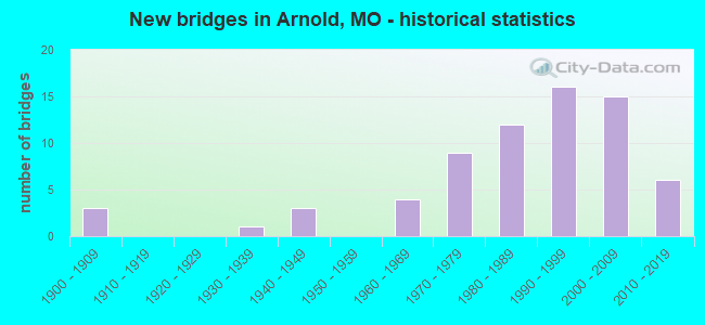
- New bridges - historical statistics
- 31900-1909
- 11930-1939
- 31940-1949
- 41960-1969
- 91970-1979
- 121980-1989
- 161990-1999
- 152000-2009
- 62010-2019
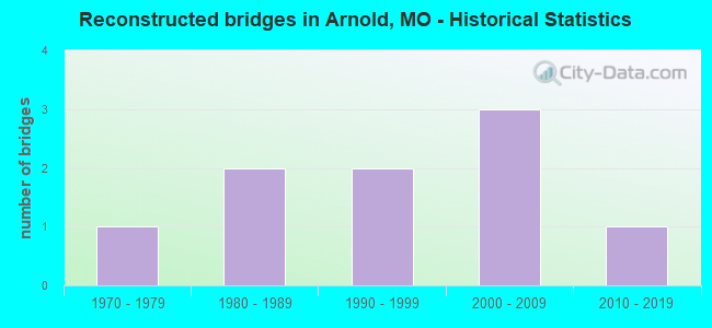
- Reconstructed bridges - Historical Statistics
- 11970-1979
- 21980-1989
- 21990-1999
- 32000-2009
- 12010-2019
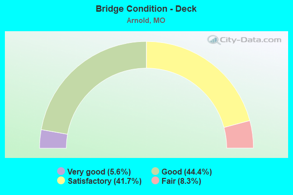
- Bridge Condition - Deck
- 5.6%Very good
- 44.4%Good
- 41.7%Satisfactory
- 8.3%Fair
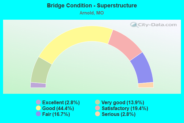
- Bridge Condition - Superstructure
- 2.8%Excellent
- 13.9%Very good
- 44.4%Good
- 19.4%Satisfactory
- 16.7%Fair
- 2.8%Serious
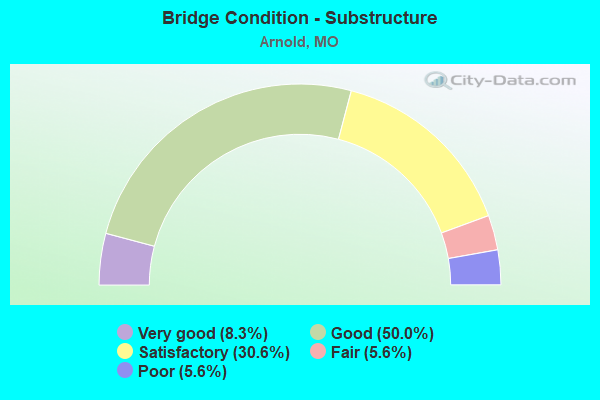
- Bridge Condition - Substructure
- 8.3%Very good
- 50.0%Good
- 30.6%Satisfactory
- 5.6%Fair
- 5.6%Poor
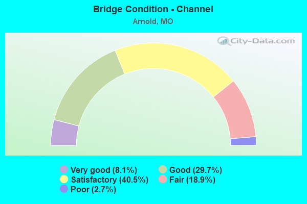
- Bridge Condition - Channel
- 8.1%Very good
- 29.7%Good
- 40.5%Satisfactory
- 18.9%Fair
- 2.7%Poor
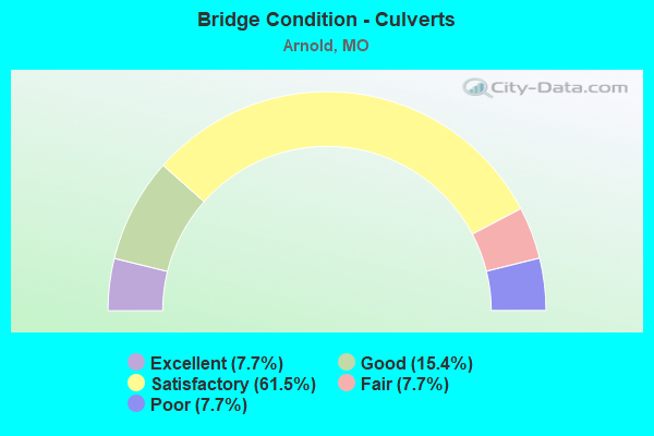
- Bridge Condition - Culverts
- 7.7%Excellent
- 15.4%Good
- 61.5%Satisfactory
- 7.7%Fair
- 7.7%Poor
Find on map >> Show street view
Structure Number: 4253, Location: S 17 T 43 N R 6 E (Lat: 38.461708, Lng: -90.373869), Route carried "on" structure: County highway , Year Built: 1996, Status: Open, Structure Length: 8.53m (27.99ft), Average Daily Traffic: 7,459 (year 2021), Truck Traffic: 6%, Average Future Daily Traffic: 11,189 (year 2041), Design Load: HS 20+Mod, Features Intersected: IS 55, Facility Carried by Structure: MERAMEC BOTTOM RD
Minimum Vertical Clearance: 30+ m (98+ ft), Kilometerpoint: 4.487, Lanes on structure: 5, Lanes under structure: 10, Owner: State Highway Agency, Approaching Roadway Width: 25.6m (84.0ft), Skew: 20 degrees, Material/Design: Steel continuous, Design/Construction: Stringer/Multi-beam, Number Of Spans In Main Unit: 2, Length of Maximum Span: 42.7m (140.1ft), Curb or Sidewalk Widths: Left: 0.2m (0.7ft), Right: 0.2m (0.7ft), Curb-To-Curb Width: 24.4m (80.1ft), Out-to-Out Width: 26.4m (86.6ft)
Condition: Deck: Satisfactory, Superstructure: Good, Substructure: Satisfactory, Operating Rating: 69.3 metric tons, Method Used To Determine Operating Rating: Load Factor (LF), Inventory Rating: 41.4 metric tons, Method Used To Determine Inventory Rating: Load Factor (LF), Structural Evaluation: Equal to present minimum criteria, Deck Geometry: Superior to present desirable criteria, Underclear: Equal to present minimum criteria, Approach Roadway Alignment: Equal to present desirable criteria, Designated Inspection Frequency: Every 24 months, Inspection Date: July 2020, Deck Structure Type: Concrete Cast-file-Place, Wearing Surface/Protective System: Wearing Surface: Epoxy Overlay, Deck Protection: Epoxy Coated Reinforcing
Find on map >> Show street view
Structure Number: 4399, Location: S 31 T 43 N R 6 E (Lat: 38.417731, Lng: -90.388061), Route carried "on" structure: Ramp State highway , Year Built: 1996, Status: Open, Structure Length: 14.36m (47.11ft), Average Daily Traffic: 10,482 (year 2021), Truck Traffic: 18%, Average Future Daily Traffic: 19,392 (year 2041), Design Load: HS 20+Mod, Features Intersected: IS 55, Facility Carried by Structure: RP RICHARDSON RD T
Minimum Vertical Clearance: 30+ m (98+ ft), Kilometerpoint: 0.117, Lanes on structure: 2, Lanes under structure: 9, Base Highway Network: Yes, Owner: State Highway Agency, Approaching Roadway Width: 11.9m (39.0ft), Skew: 5 degrees, Material/Design: Steel continuous, Design/Construction: Stringer/Multi-beam, Number Of Spans In Main Unit: 2, Number Of Approach Spans: 2, Length of Maximum Span: 57.0m (187.0ft), Curb or Sidewalk Widths: Left: 0.2m (0.7ft), Right: 0.2m (0.7ft), Curb-To-Curb Width: 12.0m (39.4ft), Out-to-Out Width: 12.8m (42.0ft)
Condition: Deck: Good, Superstructure: Satisfactory, Substructure: Satisfactory, Operating Rating: 92.7 metric tons, Method Used To Determine Operating Rating: Load Factor (LF), Inventory Rating: 55.8 metric tons, Method Used To Determine Inventory Rating: Load Factor (LF), Structural Evaluation: Equal to present minimum criteria, Deck Geometry: Superior to present desirable criteria, Underclear: Equal to present minimum criteria, Approach Roadway Alignment: Equal to present desirable criteria, Designated Inspection Frequency: Every 24 months, Inspection Date: November 2020, Deck Structure Type: Concrete Cast-file-Place, Wearing Surface/Protective System: Wearing Surface: Monolithic Concrete, Deck Protection: Epoxy Coated Reinforcing
Find on map >> Show street view
Structure Number: 44, Location: S 36 T 49 N R 28 W (Lat: 39.011450, Lng: -94.068603), Route carried "on" structure: State highway D, Year Built: 1963, Status: Open, Structure Length: 6.25m (20.51ft), Average Daily Traffic: 1,112 (year 2021), Truck Traffic: 9%, Average Future Daily Traffic: 1,612 (year 2041), Design Load: H 15, Features Intersected: IS 70
Minimum Vertical Clearance: 30+ m (98+ ft), Kilometerpoint: 15.921, Lanes on structure: 2, Lanes under structure: 4, Owner: State Highway Agency, Approaching Roadway Width: 7.3m (24.0ft), Material/Design: Concrete continuous, Design/Construction: Slab, Number Of Spans In Main Unit: 4, Length of Maximum Span: 17.1m (56.1ft), Curb-To-Curb Width: 7.9m (25.9ft), Out-to-Out Width: 8.7m (28.5ft)
Condition: Deck: Fair, Superstructure: Fair, Substructure: Good, Operating Rating: 45.9 metric tons, Method Used To Determine Operating Rating: Allowable Stress (AS), Inventory Rating: 22.5 metric tons, Method Used To Determine Inventory Rating: Allowable Stress (AS), Structural Evaluation: Somewhat better than minimum adequacy, Deck Geometry: Meets minimum limits, Underclear: Meets minimum limits, Approach Roadway Alignment: Equal to present desirable criteria, Designated Inspection Frequency: Every 24 months, Inspection Date: January 2021, Deck Structure Type: Concrete Cast-file-Place, Wearing Surface/Protective System: Wearing Surface: Bituminous
Find on map >> Show street view
Structure Number: 44, Location: S 31 T 43 N R 6 E (Lat: 38.415672, Lng: -90.388861), Route carried "on" structure: City street , Year Built: 1996, Status: Open, Structure Length: 14.42m (47.31ft), Average Daily Traffic: 24,187 (year 2021), Truck Traffic: 5%, Average Future Daily Traffic: 41,118 (year 2041), Design Load: HS 20+Mod, Features Intersected: IS 55, Facility Carried by Structure: RICHARDSON RD E
Minimum Vertical Clearance: 30+ m (98+ ft), Kilometerpoint: 1.593, Lanes on structure: 4, Lanes under structure: 8, Owner: State Highway Agency, Approaching Roadway Width: 25.0m (82.0ft), Skew: 3 degrees, Material/Design: Prestressed concrete continuous, Design/Construction: Tee Beam, Number Of Spans In Main Unit: 4, Length of Maximum Span: 38.0m (124.7ft), Curb or Sidewalk Widths: Left: 0.2m (0.7ft), Right: 0.2m (0.7ft), Curb-To-Curb Width: 25.2m (82.7ft), Out-to-Out Width: 26.0m (85.3ft)
Condition: Deck: Satisfactory, Superstructure: Good, Substructure: Good, Operating Rating: 67.5 metric tons, Method Used To Determine Operating Rating: Load Factor (LF), Inventory Rating: 40.5 metric tons, Method Used To Determine Inventory Rating: Load Factor (LF), Structural Evaluation: Better than present minimum criteria, Deck Geometry: Superior to present desirable criteria, Underclear: Equal to present minimum criteria, Approach Roadway Alignment: Equal to present desirable criteria, Designated Inspection Frequency: Every 24 months, Inspection Date: November 2020, Deck Structure Type: Concrete Cast-file-Place, Wearing Surface/Protective System: Wearing Surface: Monolithic Concrete, Deck Protection: Epoxy Coated Reinforcing
Find on map >> Show street view
Structure Number: 442, Location: S 403 T 43 N R 6 E (Lat: 38.452925, Lng: -90.376522), Route carried "on" structure: Interstate 55, Year Built: 1964, Year Reconstructed: 1993, Status: Posted for load, Structure Length: 43.43m (142.49ft), Average Daily Traffic: 57,205 (year 2021), Truck Traffic: 18%, Average Future Daily Traffic: 105,829 (year 2041), Design Load: HS 20+Mod, Features Intersected: MERAMEC RVR
Minimum Vertical Clearance: 30+ m (98+ ft), Kilometerpoint: 310.260, Lanes on structure: 5, Base Highway Network: Yes, Owner: State Highway Agency, Approaching Roadway Width: 22.3m (73.2ft), Skew: 3 degrees, Material/Design: Steel continuous, Design/Construction: Stringer/Multi-beam, Number Of Spans In Main Unit: 5, Number Of Approach Spans: 10, Length of Maximum Span: 56.4m (185.0ft), Curb or Sidewalk Widths: Left: 0.2m (0.7ft), Right: 0.2m (0.7ft), Curb-To-Curb Width: 22.5m (73.8ft), Out-to-Out Width: 23.3m (76.4ft)
Condition: Deck: Good, Superstructure: Fair, Substructure: Good, Channel: Good, Operating Rating: 46.8 metric tons, Method Used To Determine Operating Rating: Load Factor (LF), Inventory Rating: 27.9 metric tons, Method Used To Determine Inventory Rating: Load Factor (LF), Structural Evaluation: Somewhat better than minimum adequacy, Deck Geometry: Meets minimum limits, Waterway Adequacy: Equal to present minimum criteria, Approach Roadway Alignment: Equal to present desirable criteria, Designated Inspection Frequency: Every 24 months, Other Special Inspection Frequency: Every 24 months, Inspection Date: July 2020, Other Special Inspection Date: July 2020, Deck Structure Type: Concrete Cast-file-Place, Wearing Surface/Protective System: Wearing Surface: Monolithic Concrete, Deck Protection: Epoxy Coated Reinforcing
Find on map >> Show street view
Structure Number: 5881, Location: S 13 T 43 N R 4 E (Lat: 38.462922, Lng: -90.414889), Route carried "on" structure: State highway 21, Year Built: 1940, Year Reconstructed: 2009, Status: Posted for load, Structure Length: 19.75m (64.80ft), Average Daily Traffic: 18,030 (year 2021), Truck Traffic: 5%, Average Future Daily Traffic: 25,242 (year 2041), Design Load: H 20, Features Intersected: MERAMEC RVR, CRD MERAMEC
Minimum Vertical Clearance: 4.27m (14.01ft), Kilometerpoint: 13.074, Lanes on structure: 4, Lanes under structure: 2, Base Highway Network: Yes, Owner: State Highway Agency, Approaching Roadway Width: 17.1m (56.1ft), Material/Design: Steel continuous, Design/Construction: Truss - Thru, Number Of Spans In Main Unit: 3, Length of Maximum Span: 80.5m (264.1ft), Curb-To-Curb Width: 14.1m (46.3ft), Out-to-Out Width: 15.8m (51.8ft)
Condition: Deck: Satisfactory, Superstructure: Fair, Substructure: Satisfactory, Channel: Good, Operating Rating: 59.4 metric tons, Method Used To Determine Operating Rating: Load Factor (LF), Inventory Rating: 36.9 metric tons, Method Used To Determine Inventory Rating: Load Factor (LF), Structural Evaluation: Somewhat better than minimum adequacy, Deck Geometry: High priority of replacement, Waterway Adequacy: Equal to present minimum criteria, Approach Roadway Alignment: Equal to present desirable criteria, Length Of Structure Improvement: 2.03m (6.66ft), Designated Inspection Frequency: Every 24 months, Critical Feature Inspection Frequency: Every 24 months, Inspection Date: June 2021, Critical Feature Inspection Date: June 2021, Bridge Improvement Cost: $8,800,000, Roadway Improvement Cost: $880,000, Total Project Cost: $13,200,000 ( Estimate for 2022), Deck Structure Type: Concrete Cast-file-Place, Wearing Surface/Protective System: Wearing Surface: Monolithic Concrete, Deck Protection: Epoxy Coated Reinforcing
Find on map >> Show street view
Structure Number: 639, Location: S 2991 T 43 N R 6 E (Lat: 38.425500, Lng: -90.384608), Route carried "on" structure: Interstate 55, Year Built: 1965, Year Reconstructed: 2000, Status: Open, Structure Length: 1.06m (3.48ft), Average Daily Traffic: 100,663 (year 2021), Truck Traffic: 18%, Average Future Daily Traffic: 186,227 (year 2041), Design Load: HS 20, Features Intersected: TOM CR
Minimum Vertical Clearance: 30+ m (98+ ft), Kilometerpoint: 30.454, Lanes on structure: 10, Base Highway Network: Yes, Owner: State Highway Agency, Approaching Roadway Width: 39.0m (128.0ft), Skew: 20 degrees, Material/Design: Concrete continuous, Design/Construction: Culvert, Number Of Spans In Main Unit: 3, Length of Maximum Span: 3.4m (11.2ft)
Condition: Channel: Satisfactory, Culverts: Satisfactory, Operating Rating: 72.0 metric tons, Method Used To Determine Operating Rating: Field evaluation and documented engineering judgment, Inventory Rating: 43.2 metric tons, Method Used To Determine Inventory Rating: Field evaluation and documented engineering judgment, Structural Evaluation: Equal to present minimum criteria, Waterway Adequacy: Equal to present desirable criteria, Approach Roadway Alignment: Equal to present desirable criteria, Designated Inspection Frequency: Every 24 months, Inspection Date: December 2020
Find on map >> Show street view
Structure Number: 12094, Location: S 2991 T 43 N R 6 E (Lat: 38.442000, Lng: -90.379978), Route carried "under" structure: Interstate 55, Year Built: 2001, Structure Length: 0. m, Average Daily Traffic: 50,159 (year 2021), Truck Traffic: 18%, Features Intersected: IS 55, Facility Carried by Structure: MO 141 S
Minimum Vertical Clearance: 5.54m (18.18ft), Kilometerpoint: 309.120, Lanes on structure: 8, Lanes under structure: 4, Material/Design: Steel continuous, Design/Construction: Stringer/Multi-beam, Length of Maximum Span: 53.4m (175.2ft)
Find on map >> Show street view
Structure Number: 12094, Location: S 2991 T 43 N R 6 E (Lat: 38.442000, Lng: -90.379978), Route carried "under" structure: Interstate 55, Year Built: 2001, Structure Length: 0. m, Average Daily Traffic: 50,504 (year 2021), Truck Traffic: 18%, Features Intersected: IS 55, Facility Carried by Structure: MO 141 S
Minimum Vertical Clearance: 5.16m (16.93ft), Kilometerpoint: 28.600, Lanes on structure: 8, Lanes under structure: 4, Material/Design: Steel continuous, Design/Construction: Stringer/Multi-beam, Length of Maximum Span: 53.4m (175.2ft)
Find on map >> Show street view
Structure Number: 12095, Location: S 2991 T 43 N R 6 E (Lat: 38.434619, Lng: -90.382325), Route carried "under" structure: Interstate 55, Year Built: 2001, Structure Length: 0. m, Average Daily Traffic: 50,504 (year 2021), Truck Traffic: 18%, Features Intersected: IS 55, Facility Carried by Structure: CHURCH RD E
Minimum Vertical Clearance: 5.26m (17.26ft), Kilometerpoint: 29.433, Lanes on structure: 5, Lanes under structure: 5, Material/Design: Steel continuous, Design/Construction: Stringer/Multi-beam, Length of Maximum Span: 42.1m (138.1ft)
Find on map >> Show street view
Structure Number: 12095, Location: S 2991 T 43 N R 6 E (Lat: 38.434619, Lng: -90.382325), Route carried "under" structure: Interstate 55, Year Built: 2001, Structure Length: 0. m, Average Daily Traffic: 50,159 (year 2021), Truck Traffic: 18%, Features Intersected: IS 55, Facility Carried by Structure: CHURCH RD E
Minimum Vertical Clearance: 5.41m (17.75ft), Kilometerpoint: 308.266, Lanes on structure: 5, Lanes under structure: 5, Material/Design: Steel continuous, Design/Construction: Stringer/Multi-beam, Length of Maximum Span: 42.1m (138.1ft)
Find on map >> Show street view
Structure Number: 232, Location: S 664 T 43 N R 5 E (Lat: 38.461883, Lng: -90.423836), Route carried "under" structure: State highway 21, Year Built: 1976, Structure Length: 0. m, Average Daily Traffic: 12,377 (year 2021), Truck Traffic: 6%, Features Intersected: MO 21, Facility Carried by Structure: MO 141 S
Minimum Vertical Clearance: 5.11m (16.77ft), Kilometerpoint: 13.964, Lanes on structure: 6, Lanes under structure: 2, Material/Design: Steel continuous, Design/Construction: Stringer/Multi-beam, Length of Maximum Span: 21.9m (71.9ft)
Find on map >> Show street view
Structure Number: 232, Location: S 664 T 43 N R 5 E (Lat: 38.461883, Lng: -90.423836), Route carried "under" structure: State highway 21, Year Built: 1976, Structure Length: 0. m, Average Daily Traffic: 14,139 (year 2021), Truck Traffic: 20%, Features Intersected: MO 21, Facility Carried by Structure: MO 141 S
Minimum Vertical Clearance: 5.11m (16.77ft), Kilometerpoint: 298.465, Lanes on structure: 6, Lanes under structure: 2, Material/Design: Steel continuous, Design/Construction: Stringer/Multi-beam, Length of Maximum Span: 21.9m (71.9ft)
Find on map >> Show street view
Structure Number: 266, Location: S 22 T 43 N R 5 E (Lat: 38.454064, Lng: -90.438864), Route carried "under" structure: ServiceState highway 21, Year Built: 1978, Structure Length: 0. m, Average Daily Traffic: 5,660 (year 2021), Truck Traffic: 5%, Features Intersected: OR 21
Minimum Vertical Clearance: 4.95m (16.24ft), Kilometerpoint: 2.443, Lanes on structure: 2, Lanes under structure: 1, Material/Design: Prestressed concrete continuous, Design/Construction: Stringer/Multi-beam, Length of Maximum Span: 22.7m (74.5ft)
Find on map >> Show street view
Structure Number: 2661, Location: S 22 T 43 N R 5 E (Lat: 38.450089, Lng: -90.442147), Route carried "under" structure: County highway , Year Built: 1987, Structure Length: 0. m, Average Daily Traffic: 1,693 (year 2021), Truck Traffic: 3%, Features Intersected: CRD LONEDELL RD, Facility Carried by Structure: MO 21 N
Minimum Vertical Clearance: 4.52m (14.83ft), Kilometerpoint: 0.288, Lanes on structure: 2, Lanes under structure: 2, Material/Design: Prestressed concrete continuous, Design/Construction: Stringer/Multi-beam, Length of Maximum Span: 16.2m (53.1ft)
Find on map >> Show street view
Structure Number: 2662, Location: S 22 T 43 N R 5 E (Lat: 38.450272, Lng: -90.442439), Route carried "under" structure: County highway , Year Built: 1987, Structure Length: 0. m, Average Daily Traffic: 1,693 (year 2021), Truck Traffic: 3%, Features Intersected: CRD LONEDELL RD, Facility Carried by Structure: MO 21 S
Minimum Vertical Clearance: 4.42m (14.50ft), Kilometerpoint: 0.254, Lanes on structure: 2, Lanes under structure: 2, Material/Design: Prestressed concrete continuous, Design/Construction: Stringer/Multi-beam, Length of Maximum Span: 16.2m (53.1ft)
Find on map >> Show street view
Structure Number: 2663, Location: S 27 T 43 N R 5 E (Lat: 38.441306, Lng: -90.456389), Route carried "under" structure: State highway 21, Year Built: 1987, Structure Length: 0. m, Average Daily Traffic: 9,186 (year 2021), Truck Traffic: 4%, Features Intersected: MO 21
Minimum Vertical Clearance: 5.21m (17.09ft), Kilometerpoint: 294.704, Lanes on structure: 2, Lanes under structure: 2, Material/Design: Steel continuous, Design/Construction: Stringer/Multi-beam, Length of Maximum Span: 33.8m (110.9ft)
Find on map >> Show street view
Structure Number: 2663, Location: S 27 T 43 N R 5 E (Lat: 38.441306, Lng: -90.456389), Route carried "under" structure: State highway 21, Year Built: 1987, Structure Length: 0. m, Average Daily Traffic: 8,145 (year 2021), Truck Traffic: 4%, Features Intersected: MO 21
Minimum Vertical Clearance: 5.51m (18.08ft), Kilometerpoint: 17.716, Lanes on structure: 2, Lanes under structure: 2, Material/Design: Steel continuous, Design/Construction: Stringer/Multi-beam, Length of Maximum Span: 33.8m (110.9ft)
Find on map >> Show street view
Structure Number: 2664, Location: S 28 T 43 N R 5 E (Lat: 38.437739, Lng: -90.462081), Route carried "under" structure: State highway 21, Year Built: 1987, Structure Length: 0. m, Average Daily Traffic: 9,186 (year 2021), Truck Traffic: 4%, Features Intersected: MO 21, Facility Carried by Structure: WEST ROCK CREEK RD
Minimum Vertical Clearance: 5.05m (16.57ft), Kilometerpoint: 294.087, Lanes on structure: 2, Lanes under structure: 2, Material/Design: Steel continuous, Design/Construction: Stringer/Multi-beam, Length of Maximum Span: 36.6m (120.1ft)
Find on map >> Show street view
Structure Number: 2664, Location: S 28 T 43 N R 5 E (Lat: 38.437739, Lng: -90.462081), Route carried "under" structure: State highway 21, Year Built: 1987, Structure Length: 0. m, Average Daily Traffic: 8,145 (year 2021), Truck Traffic: 4%, Features Intersected: MO 21, Facility Carried by Structure: WEST ROCK CREEK RD
Minimum Vertical Clearance: 5.05m (16.57ft), Kilometerpoint: 18.369, Lanes on structure: 2, Lanes under structure: 2, Material/Design: Steel continuous, Design/Construction: Stringer/Multi-beam, Length of Maximum Span: 36.6m (120.1ft)
Find on map >> Show street view
Structure Number: 4253, Location: S 17 T 43 N R 6 E (Lat: 38.461708, Lng: -90.373869), Route carried "under" structure: Interstate 55, Year Built: 1996, Structure Length: 0. m, Average Daily Traffic: 57,205 (year 2021), Truck Traffic: 18%, Features Intersected: IS 55, Facility Carried by Structure: MERAMEC BOTTOM RD
Minimum Vertical Clearance: 5.21m (17.09ft), Kilometerpoint: 311.367, Lanes on structure: 5, Lanes under structure: 5, Material/Design: Steel continuous, Design/Construction: Stringer/Multi-beam, Length of Maximum Span: 42.7m (140.1ft)
Find on map >> Show street view
Structure Number: 4253, Location: S 17 T 43 N R 6 E (Lat: 38.461708, Lng: -90.373869), Route carried "under" structure: Interstate 55, Year Built: 1996, Structure Length: 0. m, Average Daily Traffic: 62,013 (year 2021), Truck Traffic: 18%, Features Intersected: IS 55, Facility Carried by Structure: MERAMEC BOTTOM RD
Minimum Vertical Clearance: 5.16m (16.93ft), Kilometerpoint: 26.332, Lanes on structure: 5, Lanes under structure: 5, Material/Design: Steel continuous, Design/Construction: Stringer/Multi-beam, Length of Maximum Span: 42.7m (140.1ft)
Find on map >> Show street view
Structure Number: 4399, Location: S 31 T 43 N R 6 E (Lat: 38.417731, Lng: -90.388061), Route carried "under" structure: Interstate 55, Year Built: 1996, Structure Length: 0. m, Average Daily Traffic: 50,159 (year 2021), Truck Traffic: 18%, Features Intersected: IS 55, Facility Carried by Structure: RP RICHARDSON RD T
Minimum Vertical Clearance: 5.31m (17.42ft), Kilometerpoint: 306.333, Lanes on structure: 2, Lanes under structure: 4, Material/Design: Steel continuous, Design/Construction: Stringer/Multi-beam, Length of Maximum Span: 57.0m (187.0ft)
Find on map >> Show street view
Structure Number: 4399, Location: S 31 T 43 N R 6 E (Lat: 38.417731, Lng: -90.388061), Route carried "under" structure: Interstate 55, Year Built: 1996, Structure Length: 0. m, Average Daily Traffic: 50,504 (year 2021), Truck Traffic: 18%, Features Intersected: IS 55, Facility Carried by Structure: RP RICHARDSON RD T
Minimum Vertical Clearance: 5.33m (17.49ft), Kilometerpoint: 31.381, Lanes on structure: 2, Lanes under structure: 5, Material/Design: Steel continuous, Design/Construction: Stringer/Multi-beam, Length of Maximum Span: 57.0m (187.0ft)
Find on map >> Show street view
Structure Number: 44, Location: S 31 T 43 N R 6 E (Lat: 38.415672, Lng: -90.388861), Route carried "under" structure: Interstate 55, Year Built: 1996, Structure Length: 0. m, Average Daily Traffic: 50,504 (year 2021), Truck Traffic: 18%, Features Intersected: IS 55, Facility Carried by Structure: RICHARDSON RD E
Minimum Vertical Clearance: 5.54m (18.18ft), Kilometerpoint: 31.601, Lanes on structure: 4, Lanes under structure: 4, Material/Design: Prestressed concrete continuous, Design/Construction: Tee Beam, Length of Maximum Span: 38.0m (124.7ft)
Find on map >> Show street view
Structure Number: 44, Location: S 31 T 43 N R 6 E (Lat: 38.415672, Lng: -90.388861), Route carried "under" structure: Interstate 55, Year Built: 1996, Structure Length: 0. m, Average Daily Traffic: 59,319 (year 2021), Truck Traffic: 18%, Features Intersected: IS 55, Facility Carried by Structure: RICHARDSON RD E
Minimum Vertical Clearance: 5.94m (19.49ft), Kilometerpoint: 306.077, Lanes on structure: 4, Lanes under structure: 4, Material/Design: Prestressed concrete continuous, Design/Construction: Tee Beam, Length of Maximum Span: 38.0m (124.7ft)
Find on map >> Show street view
Structure Number: 5881, Location: S 13 T 43 N R 4 E (Lat: 38.462922, Lng: -90.414889), Route carried "under" structure: County highway , Year Built: 1940, Structure Length: 0. m, Average Daily Traffic: 4,602 (year 2021), Truck Traffic: 5%, Features Intersected: CRD MERAMEC BOTTOM RD, Facility Carried by Structure: MO 21 S
Minimum Vertical Clearance: 5.59m (18.34ft), Kilometerpoint: 0.000, Lanes on structure: 4, Lanes under structure: 2, Material/Design: Steel continuous, Design/Construction: Truss - Thru, Length of Maximum Span: 80.5m (264.1ft)