Bridge Statistics for Athens, Texas (TX)
Condition, Traffic, Stress, Structural Evaluation, Project Costs
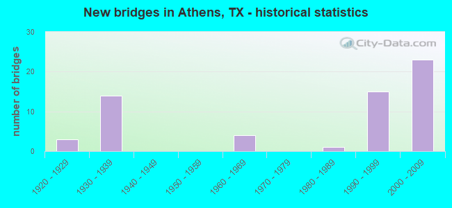
- New bridges - historical statistics
- 31920-1929
- 141930-1939
- 41960-1969
- 11980-1989
- 151990-1999
- 232000-2009
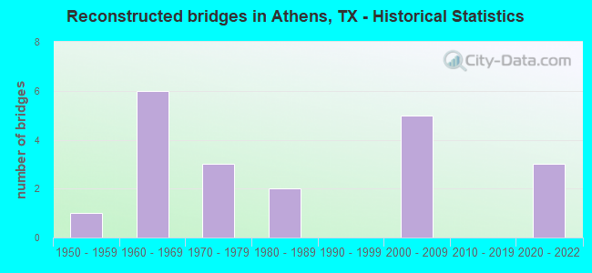
- Reconstructed bridges - Historical Statistics
- 11950-1959
- 61960-1969
- 31970-1979
- 21980-1989
- 01990-1999
- 52000-2009
- 02010-2019
- 32020-2022
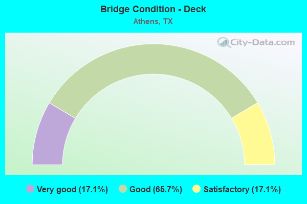
- Bridge Condition - Deck
- 17.1%Very good
- 65.7%Good
- 17.1%Satisfactory
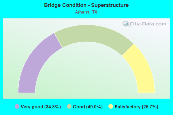
- Bridge Condition - Superstructure
- 34.3%Very good
- 40.0%Good
- 25.7%Satisfactory
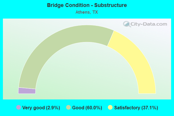
- Bridge Condition - Substructure
- 2.9%Very good
- 60.0%Good
- 37.1%Satisfactory
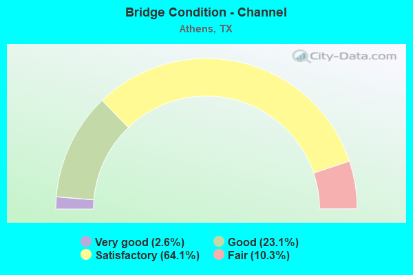
- Bridge Condition - Channel
- 2.6%Very good
- 23.1%Good
- 64.1%Satisfactory
- 10.3%Fair
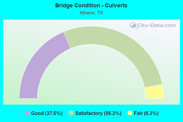
- Bridge Condition - Culverts
- 37.5%Good
- 56.3%Satisfactory
- 6.3%Fair
Find on map >> Show street view
Structure Number: 101080AA1507101, Location: 0.8 MI S OF SH 31 (Lat: 32.179433, Lng: -95.925883), Route carried "on" structure: County highway 1507, Year Built: 1996, Year Reconstructed: 2020, Status: Open, Structure Length: 1.04m (3.41ft), Average Daily Traffic: 35 (year 2018), Average Future Daily Traffic: 75 (year 2038), Features Intersected: WALNUT CR
Minimum Vertical Clearance: 30+ m (98+ ft), Kilometerpoint: 1.287, Lanes on structure: 1, Owner: County Highway Agency, Approaching Roadway Width: 3.7m (12.1ft), Skew: 10 degrees, Material/Design: Steel, Design/Construction: Stringer/Multi-beam, Number Of Spans In Main Unit: 1, Length of Maximum Span: 7.0m (23.0ft), Curb-To-Curb Width: 6.0m (19.7ft), Out-to-Out Width: 6.1m (20.0ft)
Condition: Deck: Very good, Superstructure: Satisfactory, Substructure: Satisfactory, Channel: Satisfactory, Operating Rating: 68.0 metric tons, Method Used To Determine Operating Rating: Load Factor (LF), Inventory Rating: 40.8 metric tons, Method Used To Determine Inventory Rating: Load Factor (LF), Structural Evaluation: Equal to present minimum criteria, Deck Geometry: Meets minimum limits, Waterway Adequacy: Better than present minimum criteria, Approach Roadway Alignment: Equal to present desirable criteria, Length Of Structure Improvement: 0.98m (3.22ft), Designated Inspection Frequency: Every 24 months, Inspection Date: July 2021, Bridge Improvement Cost: $40,000, Roadway Improvement Cost: $2,000, Total Project Cost: $42,000, Deck Structure Type: Concrete Cast-file-Place
Find on map >> Show street view
Structure Number: 101080AA3715001, Location: 1.70 MI N OF CR 3718 (Lat: 32.250969, Lng: -95.837983), Route carried "on" structure: County highway 3715, Year Built: 2000, Year Reconstructed: 2011, Status: Open, Structure Length: 1.52m (4.99ft), Average Daily Traffic: 110 (year 2010), Average Future Daily Traffic: 150 (year 2030), Features Intersected: SECOND CANEY CR
Minimum Vertical Clearance: 30+ m (98+ ft), Kilometerpoint: 2.736, Lanes on structure: 1, Owner: County Highway Agency, Approaching Roadway Width: 4.9m (16.1ft), Material/Design: Steel continuous, Design/Construction: Stringer/Multi-beam, Number Of Spans In Main Unit: 2, Length of Maximum Span: 7.6m (24.9ft), Curb-To-Curb Width: 5.8m (19.0ft), Out-to-Out Width: 6.0m (19.7ft)
Condition: Deck: Good, Superstructure: Satisfactory, Substructure: Satisfactory, Channel: Satisfactory, Operating Rating: 44.4 metric tons, Method Used To Determine Operating Rating: Allowable Stress (AS), Inventory Rating: 32.7 metric tons, Method Used To Determine Inventory Rating: Allowable Stress (AS), Structural Evaluation: Equal to present minimum criteria, Deck Geometry: High priority of corrective action, Waterway Adequacy: Meets minimum limits, Approach Roadway Alignment: Equal to present desirable criteria, Length Of Structure Improvement: 1.49m (4.89ft), Designated Inspection Frequency: Every 24 months, Inspection Date: January 2020, Bridge Improvement Cost: $2,000, Roadway Improvement Cost: $1,000, Total Project Cost: $3,000, Deck Structure Type: Concrete Cast-file-Place
Find on map >> Show street view
Structure Number: 101080AA3907105, Location: 1.4 MI W OF SH 19 (Lat: 32.255819, Lng: -95.868547), Route carried "on" structure: County highway 3907, Year Built: 2003, Status: Open, Structure Length: 1.46m (4.79ft), Average Daily Traffic: 165 (year 2018), Average Future Daily Traffic: 225 (year 2038), Features Intersected: THIRD CANEY CR
Minimum Vertical Clearance: 30+ m (98+ ft), Kilometerpoint: 14.001, Lanes on structure: 2, Owner: County Highway Agency, Approaching Roadway Width: 4.9m (16.1ft), Skew: 1 degrees, Material/Design: Steel, Design/Construction: Culvert, Number Of Spans In Main Unit: 5, Length of Maximum Span: 3.0m (9.8ft)
Condition: Channel: Satisfactory, Culverts: Satisfactory, Operating Rating: 32.7 metric tons, Method Used To Determine Operating Rating: Field evaluation and documented engineering judgment, Inventory Rating: 24.5 metric tons, Method Used To Determine Inventory Rating: Field evaluation and documented engineering judgment, Structural Evaluation: Equal to present minimum criteria, Waterway Adequacy: Better than present minimum criteria, Approach Roadway Alignment: Better than present minimum criteria, Designated Inspection Frequency: Every 24 months, Inspection Date: January 2020
Find on map >> Show street view
Structure Number: 101080AA3910101, Location: 2.6 MI S OF FM 2709 (Lat: 32.270244, Lng: -95.870081), Route carried "on" structure: County highway 3910, Year Built: 1995, Year Reconstructed: 2011, Status: Open, Structure Length: 1.49m (4.89ft), Average Daily Traffic: 150 (year 2010), Average Future Daily Traffic: 60 (year 2030), Features Intersected: THIRD CANEY CR
Minimum Vertical Clearance: 30+ m (98+ ft), Kilometerpoint: 4.184, Lanes on structure: 1, Owner: County Highway Agency, Approaching Roadway Width: 4.3m (14.1ft), Material/Design: Steel, Design/Construction: Stringer/Multi-beam, Number Of Spans In Main Unit: 1, Number Of Approach Spans: 1, Length of Maximum Span: 8.8m (28.9ft), Curb-To-Curb Width: 4.9m (16.1ft), Out-to-Out Width: 4.9m (16.1ft)
Condition: Deck: Satisfactory, Superstructure: Satisfactory, Substructure: Satisfactory, Channel: Satisfactory, Operating Rating: 45.4 metric tons, Method Used To Determine Operating Rating: Allowable Stress (AS), Inventory Rating: 32.7 metric tons, Method Used To Determine Inventory Rating: Allowable Stress (AS), Structural Evaluation: Equal to present minimum criteria, Deck Geometry: High priority of replacement, Waterway Adequacy: Better than present minimum criteria, Approach Roadway Alignment: Equal to present desirable criteria, Length Of Structure Improvement: 1.52m (4.99ft), Designated Inspection Frequency: Every 24 months, Inspection Date: January 2020, Deck Structure Type: Wood or Timber, Wearing Surface/Protective System: Wearing Surface: Wood or Timber
Find on map >> Show street view
Structure Number: 101080AA4614101, Location: 0.9 MI E OF SH 19 (Lat: 32.128556, Lng: -95.803661), Route carried "on" structure: County highway 4614, Year Built: 1995, Year Reconstructed: 2020, Status: Open, Structure Length: 1.20m (3.94ft), Average Daily Traffic: 110 (year 2018), Average Future Daily Traffic: 80 (year 2038), Features Intersected: COON CR
Minimum Vertical Clearance: 30+ m (98+ ft), Kilometerpoint: 1.448, Lanes on structure: 1, Owner: County Highway Agency, Approaching Roadway Width: 4.6m (15.1ft), Material/Design: Steel, Design/Construction: Stringer/Multi-beam, Number Of Spans In Main Unit: 1, Length of Maximum Span: 11.4m (37.4ft), Curb-To-Curb Width: 5.9m (19.4ft), Out-to-Out Width: 6.0m (19.7ft)
Condition: Deck: Very good, Superstructure: Very good, Substructure: Very good, Channel: Satisfactory, Operating Rating: 44.4 metric tons, Method Used To Determine Operating Rating: Allowable Stress (AS), Inventory Rating: 33.6 metric tons, Method Used To Determine Inventory Rating: Allowable Stress (AS), Structural Evaluation: Equal to present desirable criteria, Deck Geometry: High priority of corrective action, Waterway Adequacy: Better than present minimum criteria, Approach Roadway Alignment: Equal to present desirable criteria, Length Of Structure Improvement: 1.55m (5.09ft), Designated Inspection Frequency: Every 24 months, Inspection Date: September 2020, Bridge Improvement Cost: $20,000, Roadway Improvement Cost: $5,000, Total Project Cost: $25,000, Deck Structure Type: Concrete Cast-file-Place
Find on map >> Show street view
Structure Number: 101080AA4628001, Location: 0.4 MI N OF FM 317 (Lat: 32.178017, Lng: -95.836911), Route carried "on" structure: County highway 4628, Year Built: 1920, Status: Open, Structure Length: 0.91m (2.99ft), Average Daily Traffic: 1,122 (year 2018), Average Future Daily Traffic: 1,260 (year 2038), Design Load: H 15, Features Intersected: COON CR BR
Minimum Vertical Clearance: 30+ m (98+ ft), Kilometerpoint: 3.541, Lanes on structure: 2, Owner: County Highway Agency, Approaching Roadway Width: 6.1m (20.0ft), Material/Design: Concrete, Design/Construction: Tee Beam, Number Of Spans In Main Unit: 1, Length of Maximum Span: 8.5m (27.9ft), Curb-To-Curb Width: 6.1m (20.0ft), Out-to-Out Width: 6.9m (22.6ft)
Condition: Deck: Satisfactory, Superstructure: Satisfactory, Substructure: Good, Channel: Very good, Operating Rating: 63.5 metric tons, Method Used To Determine Operating Rating: Load Factor (LF), Inventory Rating: 38.1 metric tons, Method Used To Determine Inventory Rating: Load Factor (LF), Structural Evaluation: Equal to present minimum criteria, Deck Geometry: High priority of replacement, Waterway Adequacy: Better than present minimum criteria, Approach Roadway Alignment: Equal to present desirable criteria, Length Of Structure Improvement: 0.91m (2.99ft), Designated Inspection Frequency: Every 24 months, Inspection Date: January 2020, Bridge Improvement Cost: $1,000, Total Project Cost: $1,000, Deck Structure Type: Concrete Cast-file-Place, Wearing Surface/Protective System: Wearing Surface: Bituminous
Find on map >> Show street view
Structure Number: 101080B00265001, Location: 0.25 MI E OF SH 19 (Lat: 32.213500, Lng: -95.850078), Route carried "on" structure: City street , Year Built: 1984, Status: Open, Structure Length: 0.70m (2.30ft), Average Daily Traffic: 1,090 (year 2018), Average Future Daily Traffic: 220 (year 2038), Features Intersected: ONE MILE CR BR, Facility Carried by Structure: EDMONSON AVE
Minimum Vertical Clearance: 30+ m (98+ ft), Kilometerpoint: 0.402, Lanes on structure: 2, Owner: City or Municipal Highway Agency, Approaching Roadway Width: 9.1m (29.9ft), Skew: 1 degrees, Material/Design: Concrete, Design/Construction: Culvert, Number Of Spans In Main Unit: 2, Length of Maximum Span: 3.0m (9.8ft), Curb-To-Curb Width: 9.1m (29.9ft), Out-to-Out Width: 15.2m (49.9ft)
Condition: Channel: Satisfactory, Culverts: Good, Operating Rating: 32.7 metric tons, Method Used To Determine Operating Rating: Field evaluation and documented engineering judgment, Inventory Rating: 24.5 metric tons, Method Used To Determine Inventory Rating: Field evaluation and documented engineering judgment, Structural Evaluation: Equal to present minimum criteria, Deck Geometry: Somewhat better than minimum adequacy, Waterway Adequacy: Better than present minimum criteria, Approach Roadway Alignment: Equal to present desirable criteria, Designated Inspection Frequency: Every 24 months, Inspection Date: January 2020, Bridge Improvement Cost: $27,000, Roadway Improvement Cost: $45,000, Total Project Cost: $72,000, Deck Structure Type: Concrete Cast-file-Place, Wearing Surface/Protective System: Wearing Surface: Bituminous
Find on map >> Show street view
Structure Number: 101080B00685001, Location: 0.1 MI SW OF SH 19 (Lat: 32.220853, Lng: -95.854331), Route carried "on" structure: City street , Year Built: 1935, Status: Open, Structure Length: 0.70m (2.30ft), Average Daily Traffic: 750 (year 2018), Average Future Daily Traffic: 110 (year 2038), Features Intersected: ONE MILE CR, Facility Carried by Structure: PRAIRIEVILLE ST
Minimum Vertical Clearance: 30+ m (98+ ft), Kilometerpoint: 1.207, Lanes on structure: 2, Owner: City or Municipal Highway Agency, Approaching Roadway Width: 7.3m (24.0ft), Material/Design: Concrete, Design/Construction: Culvert, Number Of Spans In Main Unit: 2, Length of Maximum Span: 3.0m (9.8ft), Curb-To-Curb Width: 10.3m (33.8ft), Out-to-Out Width: 11.3m (37.1ft)
Condition: Channel: Satisfactory, Culverts: Satisfactory, Operating Rating: 32.7 metric tons, Method Used To Determine Operating Rating: Field evaluation and documented engineering judgment, Inventory Rating: 24.5 metric tons, Method Used To Determine Inventory Rating: Field evaluation and documented engineering judgment, Structural Evaluation: Equal to present minimum criteria, Deck Geometry: Equal to present minimum criteria, Waterway Adequacy: Better than present minimum criteria, Approach Roadway Alignment: Equal to present desirable criteria, Designated Inspection Frequency: Every 24 months, Inspection Date: January 2020, Deck Structure Type: Concrete Cast-file-Place, Wearing Surface/Protective System: Wearing Surface: Bituminous
Find on map >> Show street view
Structure Number: 101080109905014, Location: 1.40 MI SE OF SH 31 E (Lat: 32.208500, Lng: -95.805200), Route carried "under" structure: State highway 2495, Year Built: 2000, Structure Length: 0. m, Average Daily Traffic: 3,870 (year 2013), Truck Traffic: 3%, Features Intersected: FM 2495, Facility Carried by Structure: US 175 (SL 7)
Minimum Vertical Clearance: 5.33m (17.49ft), Kilometerpoint: 2.459, Lanes on structure: 4, Material/Design: Prestressed concrete, Design/Construction: Stringer/Multi-beam, Length of Maximum Span: 36.6m (120.1ft)
Find on map >> Show street view
Structure Number: 101080109905017, Location: 1.95 MI SE OF SH 31 W (Lat: 32.169700, Lng: -95.893500), Route carried "under" structure: State highway 2494, Year Built: 2006, Structure Length: 0. m, Average Daily Traffic: 2,670 (year 2013), Truck Traffic: 2%, Features Intersected: FM 2494, Facility Carried by Structure: SL 7
Minimum Vertical Clearance: 6.99m (22.93ft), Kilometerpoint: 6.033, Lanes on structure: 2, Material/Design: Prestressed concrete, Design/Construction: Stringer/Multi-beam, Length of Maximum Span: 36.6m (120.1ft)
Find on map >> Show street view
Structure Number: 101080109905021, Location: 2.6 MI SW OF US 175 (Lat: 32.194000, Lng: -95.908700), Route carried "under" structure: Business State highway 31, Year Built: 2006, Structure Length: 0. m, Average Daily Traffic: 7,220 (year 2018), Truck Traffic: 2%, Features Intersected: SH 31/BS 31H (W)
Minimum Vertical Clearance: 5.66m (18.57ft), Kilometerpoint: 11.038, Lanes on structure: 6, Material/Design: Prestressed concrete, Design/Construction: Stringer/Multi-beam, Length of Maximum Span: 36.6m (120.1ft)
Find on map >> Show street view
Structure Number: 101080109905022, Location: 3.30 MI SE OF SH 31 W (Lat: 32.166000, Lng: -95.871000), Route carried "under" structure: State highway 59, Year Built: 2006, Structure Length: 0. m, Average Daily Traffic: 2,620 (year 2013), Truck Traffic: 5%, Features Intersected: FM 59, Facility Carried by Structure: SL 7
Minimum Vertical Clearance: 5.89m (19.32ft), Kilometerpoint: 3.486, Lanes on structure: 4, Material/Design: Prestressed concrete, Design/Construction: Stringer/Multi-beam, Length of Maximum Span: 36.6m (120.1ft)
Find on map >> Show street view
Structure Number: 101080109905028, Location: 2.45 MI NE OF SH 19 (Lat: 32.189800, Lng: -95.813300), Route carried "under" structure: Business State highway 175, Year Built: 2003, Structure Length: 0. m, Average Daily Traffic: 2,260 (year 2013), Truck Traffic: 23%, Features Intersected: BU 175 G
Minimum Vertical Clearance: 6.12m (20.08ft), Kilometerpoint: 5.992, Lanes on structure: 6, Material/Design: Prestressed concrete, Design/Construction: Stringer/Multi-beam, Length of Maximum Span: 32.0m (105.0ft)
Find on map >> Show street view
Structure Number: 101080109905052, Location: 1.40 MI NW OF FM 2495 (Lat: 32.226900, Lng: -95.812500), Route carried "under" structure: State highway 31, Year Built: 2000, Structure Length: 0. m, Average Daily Traffic: 7,170 (year 2013), Truck Traffic: 11%, Features Intersected: BUS 31H/SH 31
Minimum Vertical Clearance: 5.66m (18.57ft), Kilometerpoint: 21.185, Lanes on structure: 6, Material/Design: Prestressed concrete, Design/Construction: Stringer/Multi-beam, Length of Maximum Span: 39.6m (129.9ft)
Find on map >> Show street view
Structure Number: 101080109905069, Location: 2.40 MI W OF SH 31 E (Lat: 32.227000, Lng: -95.853000), Route carried "under" structure: State highway 19, Year Built: 1991, Structure Length: 0. m, Average Daily Traffic: 5,230 (year 2013), Truck Traffic: 18%, Features Intersected: BS 19 J, Facility Carried by Structure: US 175/SH 31 (SL7)
Minimum Vertical Clearance: 5.44m (17.85ft), Kilometerpoint: 14.484, Lanes on structure: 6, Material/Design: Prestressed concrete, Design/Construction: Stringer/Multi-beam, Length of Maximum Span: 38.1m (125.0ft)
Find on map >> Show street view
Structure Number: 101080109905071, Location: 1.80 MI E OF FM 59 (Lat: 32.168300, Lng: -95.842600), Route carried "under" structure: Business State highway 19, Year Built: 2003, Structure Length: 0. m, Average Daily Traffic: 8,600 (year 2013), Truck Traffic: 14%, Features Intersected: BS 19 J
Minimum Vertical Clearance: 6.43m (21.10ft), Kilometerpoint: 20.368, Lanes on structure: 6, Material/Design: Prestressed concrete, Design/Construction: Stringer/Multi-beam, Length of Maximum Span: 38.1m (125.0ft)
Find on map >> Show street view
Structure Number: 101080109905235, Location: 2.60 MI NE OF SH 31 W (Lat: 32.220100, Lng: -95.879500), Route carried "under" structure: Business State highway 175, Year Built: 1991, Structure Length: 0. m, Average Daily Traffic: 6,350 (year 2019), Truck Traffic: 15%, Features Intersected: BU 175G (W)
Minimum Vertical Clearance: 5.26m (17.26ft), Kilometerpoint: 24.681, Lanes on structure: 6, Material/Design: Prestressed concrete, Design/Construction: Stringer/Multi-beam, Length of Maximum Span: 39.6m (129.9ft)