Bridge Statistics for Athol, Idaho (ID)
Condition, Traffic, Stress, Structural Evaluation, Project Costs
- National Bridge Inventory (NBI) Statistics
- 17Number of bridges
- 161ft / 48.7mTotal length
- $5,891,000Total costs
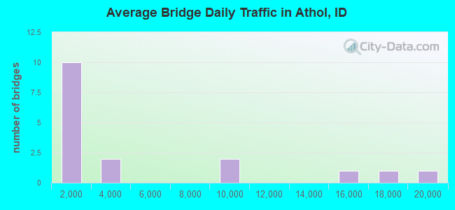
- 73,570Total average daily traffic
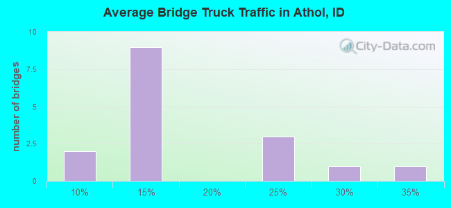
- 7,656Total average daily truck traffic
- National Bridge Inventory (NBI) Registered Bridges for Athol
- No street view available for this location
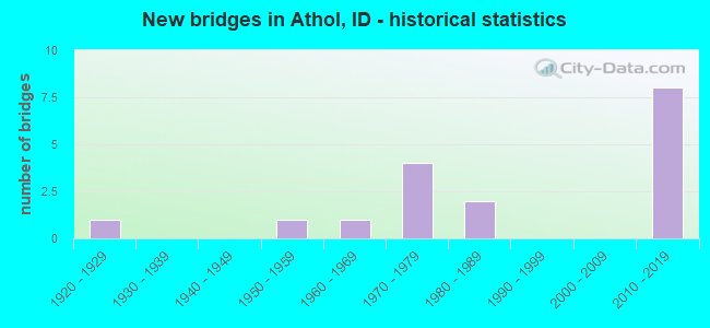
- New bridges - historical statistics
- 11920-1929
- 11950-1959
- 11960-1969
- 41970-1979
- 21980-1989
- 82010-2019
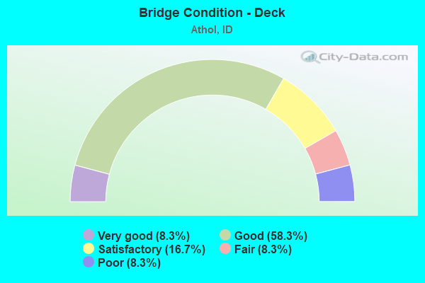
- Bridge Condition - Deck
- 8.3%Very good
- 58.3%Good
- 16.7%Satisfactory
- 8.3%Fair
- 8.3%Poor
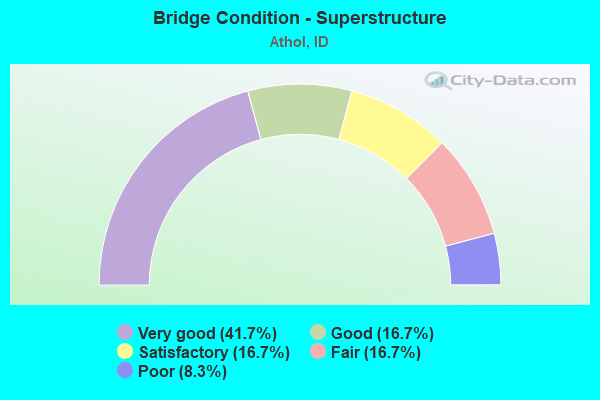
- Bridge Condition - Superstructure
- 41.7%Very good
- 16.7%Good
- 16.7%Satisfactory
- 16.7%Fair
- 8.3%Poor
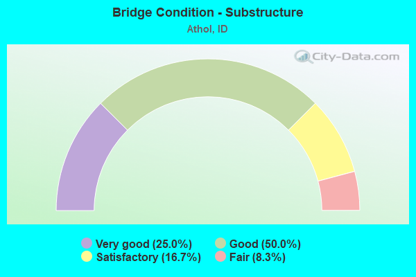
- Bridge Condition - Substructure
- 25.0%Very good
- 50.0%Good
- 16.7%Satisfactory
- 8.3%Fair
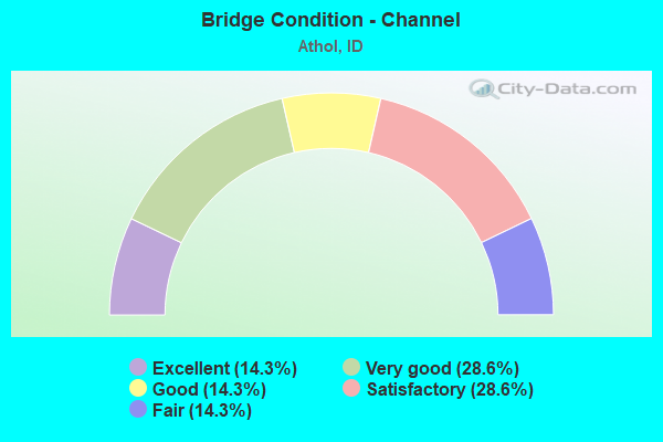
- Bridge Condition - Channel
- 14.3%Excellent
- 28.6%Very good
- 14.3%Good
- 28.6%Satisfactory
- 14.3%Fair
Find on map >> Show street view
Structure Number: 2018, Location: 1.9 S. 0.5 E. BURGDORF (Lat: 45.250861, Lng: -115.902806), Route carried "on" structure: County highway 4706, Year Built: 1975, Status: Open, Structure Length: 2.96m (9.71ft), Average Daily Traffic: 100 (year 2019), Truck Traffic: 10%, Average Future Daily Traffic: 150 (year 2039), Design Load: HS 20, Features Intersected: SUMMIT CREEK
Minimum Vertical Clearance: 30+ m (98+ ft), Kilometerpoint: 8.346, Lanes on structure: 2, Owner: County Highway Agency, Approaching Roadway Width: 9.4m (30.8ft), Skew: 4 degrees, Material/Design: Prestressed concrete, Design/Construction: Stringer/Multi-beam, Number Of Spans In Main Unit: 1, Length of Maximum Span: 28.3m (92.8ft), Curb-To-Curb Width: 8.5m (27.9ft), Out-to-Out Width: 9.5m (31.2ft)
Condition: Deck: Good, Superstructure: Good, Substructure: Good, Channel: Very good, Operating Rating: 61.7 metric tons, Method Used To Determine Operating Rating: Load Factor (LF), Inventory Rating: 27.2 metric tons, Method Used To Determine Inventory Rating: Load Factor (LF), Structural Evaluation: Equal to present minimum criteria, Deck Geometry: Better than present minimum criteria, Waterway Adequacy: Superior to present desirable criteria, Approach Roadway Alignment: Equal to present desirable criteria, Designated Inspection Frequency: Every 24 months, Inspection Date: July 2021, Deck Structure Type: Concrete Cast-file-Place, Wearing Surface/Protective System: Wearing Surface: Bituminous
Find on map >> Show street view
Structure Number: 20185, Location: 1.4 S. 0.7 E. BURGDORF (Lat: 45.256389, Lng: -115.897028), Route carried "on" structure: County highway 4706, Year Built: 1975, Status: Open, Structure Length: 2.44m (8.01ft), Average Daily Traffic: 100 (year 2019), Truck Traffic: 10%, Average Future Daily Traffic: 150 (year 2039), Design Load: HS 20, Features Intersected: LAKE CREEK
Minimum Vertical Clearance: 30+ m (98+ ft), Kilometerpoint: 9.102, Lanes on structure: 2, Owner: County Highway Agency, Approaching Roadway Width: 9.4m (30.8ft), Material/Design: Prestressed concrete, Design/Construction: Stringer/Multi-beam, Number Of Spans In Main Unit: 1, Length of Maximum Span: 23.5m (77.1ft), Curb-To-Curb Width: 8.5m (27.9ft), Out-to-Out Width: 9.5m (31.2ft)
Condition: Deck: Good, Superstructure: Very good, Substructure: Good, Channel: Very good, Operating Rating: 55.3 metric tons, Method Used To Determine Operating Rating: Load Factor (LF), Inventory Rating: 23.6 metric tons, Method Used To Determine Inventory Rating: Load Factor (LF), Structural Evaluation: Equal to present minimum criteria, Deck Geometry: Better than present minimum criteria, Waterway Adequacy: Superior to present desirable criteria, Approach Roadway Alignment: Equal to present desirable criteria, Designated Inspection Frequency: Every 24 months, Inspection Date: July 2021, Deck Structure Type: Concrete Cast-file-Place, Wearing Surface/Protective System: Wearing Surface: Bituminous
Find on map >> Show street view
Structure Number: 2021, Location: 3.8 S. 2.4 E. ELK CITY (Lat: 45.773875, Lng: -115.385883), Route carried "on" structure: County highway 4719, Year Built: 1964, Status: Open, Structure Length: 0.79m (2.59ft), Average Daily Traffic: 130 (year 2019), Truck Traffic: 23%, Average Future Daily Traffic: 195 (year 2039), Design Load: H 20, Features Intersected: SIEGEL CREEK
Minimum Vertical Clearance: 30+ m (98+ ft), Kilometerpoint: 9.775, Lanes on structure: 2, Owner: County Highway Agency, Approaching Roadway Width: 9.1m (29.9ft), Skew: 2 degrees, Material/Design: Wood or Timber, Design/Construction: Stringer/Multi-beam, Number Of Spans In Main Unit: 1, Length of Maximum Span: 7.6m (24.9ft), Curb-To-Curb Width: 7.8m (25.6ft), Out-to-Out Width: 8.4m (27.6ft)
Condition: Deck: Good, Superstructure: Good, Substructure: Good, Channel: Good, Operating Rating: 51.7 metric tons, Method Used To Determine Operating Rating: Allowable Stress (AS), Inventory Rating: 34.5 metric tons, Method Used To Determine Inventory Rating: Allowable Stress (AS), Structural Evaluation: Better than present minimum criteria, Deck Geometry: Somewhat better than minimum adequacy, Waterway Adequacy: Superior to present desirable criteria, Approach Roadway Alignment: Equal to present desirable criteria, Designated Inspection Frequency: Every 24 months, Inspection Date: June 2020, Deck Structure Type: Wood or Timber, Wearing Surface/Protective System: Wearing Surface: Bituminous
Find on map >> Show street view
Structure Number: 20215, Location: 8.1 S. 4.5 E. ELK CITY (Lat: 45.710889, Lng: -115.344333), Route carried "on" structure: County highway 4719, Year Built: 1958, Status: Open, Structure Length: 1.25m (4.10ft), Average Daily Traffic: 40 (year 2019), Truck Traffic: 25%, Average Future Daily Traffic: 60 (year 2039), Design Load: HS 15, Features Intersected: RED RIVER
Minimum Vertical Clearance: 4.88m (16.01ft), Kilometerpoint: 187.643, Lanes on structure: 2, Owner: County Highway Agency, Approaching Roadway Width: 6.1m (20.0ft), Skew: 3 degrees, Material/Design: Wood or Timber, Design/Construction: Stringer/Multi-beam, Number Of Spans In Main Unit: 1, Length of Maximum Span: 11.6m (38.1ft), Curb-To-Curb Width: 7.4m (24.3ft), Out-to-Out Width: 7.8m (25.6ft)
Condition: Deck: Satisfactory, Superstructure: Satisfactory, Substructure: Good, Channel: Excellent, Operating Rating: 42.6 metric tons, Method Used To Determine Operating Rating: Allowable Stress (AS), Inventory Rating: 29.0 metric tons, Method Used To Determine Inventory Rating: Allowable Stress (AS), Structural Evaluation: Equal to present minimum criteria, Deck Geometry: Equal to present minimum criteria, Waterway Adequacy: Superior to present desirable criteria, Approach Roadway Alignment: Equal to present desirable criteria, Designated Inspection Frequency: Every 24 months, Inspection Date: June 2021, Deck Structure Type: Wood or Timber, Wearing Surface/Protective System: Wearing Surface: Bituminous
Find on map >> Show street view
Structure Number: 23425, Location: 11.7 N. MALAD (Lat: 42.343528, Lng: -112.227333), Route carried "on" structure: County highway , Year Built: 1971, Status: Open, Structure Length: 9.27m (30.41ft), Average Daily Traffic: 150 (year 2019), Truck Traffic: 10%, Average Future Daily Traffic: 225 (year 2039), Design Load: HS 20, Features Intersected: I 15 NB-SB;SUMMIT RD.GS, Facility Carried by Structure: SUMMIT RD.
Minimum Vertical Clearance: 30+ m (98+ ft), Kilometerpoint: 164.224, Lanes on structure: 2, Lanes under structure: 4, Owner: State Highway Agency, Approaching Roadway Width: 7.9m (25.9ft), Material/Design: Steel continuous, Design/Construction: Stringer/Multi-beam, Number Of Spans In Main Unit: 2, Number Of Approach Spans: 2, Length of Maximum Span: 37.8m (124.0ft), Curb-To-Curb Width: 8.7m (28.5ft), Out-to-Out Width: 9.7m (31.8ft)
Condition: Deck: Good, Superstructure: Fair, Substructure: Good, Operating Rating: 22.7 metric tons, Method Used To Determine Operating Rating: Load and Resistance Factor (LRFR), Inventory Rating: 17.2 metric tons, Method Used To Determine Inventory Rating: Load and Resistance Factor (LRFR), Structural Evaluation: Somewhat better than minimum adequacy, Deck Geometry: Equal to present minimum criteria, Underclear: Equal to present minimum criteria, Approach Roadway Alignment: Equal to present desirable criteria, Length Of Structure Improvement: 10.27m (33.69ft), Designated Inspection Frequency: Every 24 months, Other Special Inspection Frequency: Every 48 months, Inspection Date: July 2020, Other Special Inspection Date: July 2020, Bridge Improvement Cost: $1,779,000, Roadway Improvement Cost: $178,000, Total Project Cost: $2,669,000 ( Estimate for 2017), Deck Structure Type: Concrete Cast-file-Place, Wearing Surface/Protective System: Wearing Surface: Monolithic Concrete
Find on map >> Show street view
Structure Number: 2348, Location: 0.9 N. 0.8 W. PAULINE (Lat: 42.578639, Lng: -112.570500), Route carried "on" structure: County highway , Year Built: 1981, Status: Open, Structure Length: 1.65m (5.41ft), Average Daily Traffic: 20 (year 2019), Truck Traffic: 10%, Average Future Daily Traffic: 30 (year 2039), Design Load: HS 20, Features Intersected: BANNOCK CREEK;NW PAULINE, Facility Carried by Structure: ESTEP LANE
Minimum Vertical Clearance: 30+ m (98+ ft), Kilometerpoint: 179.332, Lanes on structure: 2, Owner: County Highway Agency, Approaching Roadway Width: 8.5m (27.9ft), Material/Design: Prestressed concrete, Design/Construction: Tee Beam, Number Of Spans In Main Unit: 1, Length of Maximum Span: 15.8m (51.8ft), Curb-To-Curb Width: 8.6m (28.2ft), Out-to-Out Width: 9.2m (30.2ft)
Condition: Deck: Satisfactory, Superstructure: Satisfactory, Substructure: Satisfactory, Channel: Satisfactory, Operating Rating: 59.0 metric tons, Method Used To Determine Operating Rating: Allowable Stress (AS), Inventory Rating: 42.3 metric tons, Method Used To Determine Inventory Rating: Allowable Stress (AS), Structural Evaluation: Equal to present minimum criteria, Deck Geometry: Better than present minimum criteria, Waterway Adequacy: Better than present minimum criteria, Approach Roadway Alignment: Better than present minimum criteria, Designated Inspection Frequency: Every 48 months, Inspection Date: April 2021, Deck Structure Type: Concrete Cast-file-Place, Wearing Surface/Protective System: Wearing Surface: Gravel
Find on map >> Show street view
Structure Number: 2381, Location: 3.4 S. 2.4 E. FAIRFIELD (Lat: 43.292500, Lng: -114.746111), Route carried "on" structure: County highway , Year Built: 1986, Status: Open, Structure Length: 1.98m (6.50ft), Average Daily Traffic: 30 (year 2019), Truck Traffic: 33%, Average Future Daily Traffic: 45 (year 2039), Design Load: HS 20, Features Intersected: CAMAS CREEK, Facility Carried by Structure: FIR GROVE ROAD
Minimum Vertical Clearance: 30+ m (98+ ft), Kilometerpoint: 174.726, Lanes on structure: 2, Owner: County Highway Agency, Approaching Roadway Width: 7.3m (24.0ft), Material/Design: Steel, Design/Construction: Culvert, Number Of Spans In Main Unit: 5, Length of Maximum Span: 3.0m (9.8ft), Curb-To-Curb Width: 8.0m (26.2ft), Out-to-Out Width: 9.2m (30.2ft)
Condition: Channel: Fair, Culverts: Satisfactory, Operating Rating: 88.0 metric tons, Method Used To Determine Operating Rating: Load Factor (LF), Inventory Rating: 88.0 metric tons, Method Used To Determine Inventory Rating: Load Factor (LF), Structural Evaluation: Equal to present minimum criteria, Deck Geometry: Equal to present minimum criteria, Waterway Adequacy: Somewhat better than minimum adequacy, Approach Roadway Alignment: Equal to present desirable criteria, Designated Inspection Frequency: Every 48 months, Inspection Date: November 2021
Find on map >> Show street view
Structure Number: 2413, Location: 3.5S 1.0W DECLO;420S-750E (Lat: 42.469806, Lng: -113.647444), Route carried "on" structure: County highway , Year Built: 1977, Status: Open, Structure Length: 2.04m (6.69ft), Average Daily Traffic: 100 (year 2019), Truck Traffic: 10%, Average Future Daily Traffic: 150 (year 2039), Design Load: H 20, Features Intersected: 'J' CANAL, Facility Carried by Structure: 750 EAST ROAD
Minimum Vertical Clearance: 30+ m (98+ ft), Kilometerpoint: 162.104, Lanes on structure: 2, Owner: Local Agency, Approaching Roadway Width: 6.1m (20.0ft), Skew: 5 degrees, Material/Design: Prestressed concrete, Design/Construction: Tee Beam, Number Of Spans In Main Unit: 2, Length of Maximum Span: 9.8m (32.2ft), Curb or Sidewalk Widths: Left: 0.3m (1.0ft), Right: 0.3m (1.0ft), Curb-To-Curb Width: 8.6m (28.2ft), Out-to-Out Width: 9.2m (30.2ft)
Condition: Deck: Fair, Superstructure: Fair, Substructure: Satisfactory, Channel: Satisfactory, Operating Rating: 27.2 metric tons, Method Used To Determine Operating Rating: Field evaluation and documented engineering judgment, Inventory Rating: 16.3 metric tons, Method Used To Determine Inventory Rating: Field evaluation and documented engineering judgment, Structural Evaluation: Somewhat better than minimum adequacy, Deck Geometry: Better than present minimum criteria, Waterway Adequacy: Equal to present desirable criteria, Approach Roadway Alignment: Equal to present desirable criteria, Length Of Structure Improvement: 3.05m (10.01ft), Designated Inspection Frequency: Every 24 months, Inspection Date: March 2020, Bridge Improvement Cost: $800,000, Roadway Improvement Cost: $80,000, Total Project Cost: $880,000 ( Estimate for 2020), Deck Structure Type: Concrete Cast-file-Place, Wearing Surface/Protective System: Wearing Surface: Bituminous
Find on map >> Show street view
Structure Number: 3052, Location: 1.5 S. ATHOL (Lat: 47.928250, Lng: -116.714167), Route carried "on" structure: County highway 5751, Year Built: 1929, Status: Open, Structure Length: 5.52m (18.11ft), Average Daily Traffic: 1,000 (year 2019), Average Future Daily Traffic: 1,500 (year 2039), Design Load: H 15, Features Intersected: SIRR & UPRR;S.ATHOL OP
Minimum Vertical Clearance: 30+ m (98+ ft), Kilometerpoint: 174.481, Lanes on structure: 2, Owner: Local Agency, Approaching Roadway Width: 7.3m (24.0ft), Skew: 5 degrees, Material/Design: Concrete, Design/Construction: Tee Beam, Number Of Spans In Main Unit: 6, Length of Maximum Span: 11.3m (37.1ft), Curb or Sidewalk Widths: Left: 0.2m (0.7ft), Right: 0.2m (0.7ft), Curb-To-Curb Width: 7.3m (24.0ft), Out-to-Out Width: 8.3m (27.2ft)
Condition: Deck: Poor, Superstructure: Poor, Substructure: Fair, Operating Rating: 45.4 metric tons, Method Used To Determine Operating Rating: Load Factor (LF), Inventory Rating: 27.2 metric tons, Method Used To Determine Inventory Rating: Load Factor (LF), Structural Evaluation: Meets minimum limits, Deck Geometry: Meets minimum limits, Underclear: High priority of replacement, Approach Roadway Alignment: Better than present minimum criteria, Length Of Structure Improvement: 6.55m (21.49ft), Designated Inspection Frequency: Every 12 months, Inspection Date: October 2021, Bridge Improvement Cost: $1,561,000, Roadway Improvement Cost: $156,000, Total Project Cost: $2,342,000 ( Estimate for 2019), Deck Structure Type: Concrete Cast-file-Place, Wearing Surface/Protective System: Wearing Surface: Monolithic Concrete
Find on map >> Show street view
Structure Number: 33565, Location: 3.5 S. ATHOL (Lat: 47.880833, Lng: -116.730333), Route carried "on" structure: US 95, Year Built: 2012, Status: Open, Structure Length: 0.76m (2.49ft), Average Daily Traffic: 18,500 (year 2019), Truck Traffic: 10%, Average Future Daily Traffic: 27,750 (year 2039), Design Load: HL 93, Features Intersected: WILDLIFE CROSSING
Minimum Vertical Clearance: 30+ m (98+ ft), Kilometerpoint: 714.521, Lanes on structure: 4, Base Highway Network: Yes (Inventory Route: US0, Subroute: 1), Owner: State Highway Agency, Approaching Roadway Width: 23.3m (76.4ft), Skew: 20 degrees, Material/Design: Concrete, Design/Construction: Slab, Number Of Spans In Main Unit: 1, Length of Maximum Span: 7.6m (24.9ft), Curb-To-Curb Width: 37.4m (122.7ft), Out-to-Out Width: 38.2m (125.3ft)
Condition: Deck: Very good, Superstructure: Very good, Substructure: Very good, Operating Rating: 60.6 metric tons, Method Used To Determine Operating Rating: Load and Resistance Factor Rating (LRFR) rating reported by rating factor(RF) method using HL-93 loadings, Inventory Rating: 46.7 metric tons, Method Used To Determine Inventory Rating: Load and Resistance Factor Rating (LRFR) rating reported by rating factor(RF) method using HL-93 loadings, Structural Evaluation: Equal to present desirable criteria, Deck Geometry: Superior to present desirable criteria, Approach Roadway Alignment: Equal to present desirable criteria, Designated Inspection Frequency: Every 48 months, Inspection Date: May 2020, Deck Structure Type: Concrete Cast-file-Place, Wearing Surface/Protective System: Wearing Surface: Bituminous, Membrane: Preformed Fabric
Find on map >> Show street view
Structure Number: 33757, Location: 1.6 S. ATHOL (Lat: 47.903861, Lng: -116.708639), Route carried "on" structure: County highway , Year Built: 2012, Status: Open, Structure Length: 8.38m (27.49ft), Average Daily Traffic: 700 (year 2019), Truck Traffic: 7%, Average Future Daily Traffic: 1,050 (year 2039), Design Load: HL 93, Features Intersected: BUNCO RD; US 95 IC, Facility Carried by Structure: BUNCO ROAD
Minimum Vertical Clearance: 30+ m (98+ ft), Kilometerpoint: 161.113, Lanes on structure: 3, Lanes under structure: 5, Owner: State Highway Agency, Approaching Roadway Width: 11.0m (36.1ft), Material/Design: Prestressed concrete, Design/Construction: Stringer/Multi-beam, Number Of Spans In Main Unit: 2, Length of Maximum Span: 44.2m (145.0ft), Curb-To-Curb Width: 19.3m (63.3ft), Out-to-Out Width: 20.2m (66.3ft)
Condition: Deck: Good, Superstructure: Very good, Substructure: Good, Operating Rating: 61.6 metric tons, Method Used To Determine Operating Rating: Load and Resistance Factor Rating (LRFR) rating reported by rating factor(RF) method using HL-93 loadings, Inventory Rating: 39.9 metric tons, Method Used To Determine Inventory Rating: Load and Resistance Factor Rating (LRFR) rating reported by rating factor(RF) method using HL-93 loadings, Structural Evaluation: Better than present minimum criteria, Deck Geometry: Superior to present desirable criteria, Underclear: Superior to present desirable criteria, Approach Roadway Alignment: Equal to present desirable criteria, Designated Inspection Frequency: Every 48 months, Inspection Date: October 2020, Deck Structure Type: Concrete Cast-file-Place, Wearing Surface/Protective System: Wearing Surface: Epoxy Overlay, Deck Protection: Epoxy Coated Reinforcing
Find on map >> Show street view
Structure Number: 3376, Location: IN ATHOL (Lat: 47.947561, Lng: -116.696061), Route carried "on" structure: US 95, Year Built: 2014, Status: Open, Structure Length: 5.85m (19.19ft), Average Daily Traffic: 8,000 (year 2019), Truck Traffic: 10%, Average Future Daily Traffic: 12,000 (year 2039), Design Load: HL 93, Features Intersected: US 95/SH 54 IC
Minimum Vertical Clearance: 30+ m (98+ ft), Kilometerpoint: 722.679, Lanes on structure: 2, Lanes under structure: 4, Base Highway Network: Yes (Inventory Route: US0, Subroute: 1), Owner: State Highway Agency, Approaching Roadway Width: 12.2m (40.0ft), Material/Design: Prestressed concrete, Design/Construction: Stringer/Multi-beam, Number Of Spans In Main Unit: 3, Length of Maximum Span: 21.6m (70.9ft), Curb-To-Curb Width: 12.6m (41.3ft), Out-to-Out Width: 13.4m (44.0ft)
Condition: Deck: Good, Superstructure: Very good, Substructure: Very good, Operating Rating: 50.9 metric tons, Method Used To Determine Operating Rating: Load and Resistance Factor Rating (LRFR) rating reported by rating factor(RF) method using HL-93 loadings, Inventory Rating: 39.2 metric tons, Method Used To Determine Inventory Rating: Load and Resistance Factor Rating (LRFR) rating reported by rating factor(RF) method using HL-93 loadings, Structural Evaluation: Equal to present desirable criteria, Deck Geometry: Better than present minimum criteria, Underclear: High priority of corrective action, Approach Roadway Alignment: Equal to present desirable criteria, Designated Inspection Frequency: Every 48 months, Inspection Date: September 2020, Deck Structure Type: Concrete Cast-file-Place, Wearing Surface/Protective System: Wearing Surface: Epoxy Overlay, Deck Protection: Epoxy Coated Reinforcing
Find on map >> Show street view
Structure Number: 33765, Location: IN ATHOL (Lat: 47.948075, Lng: -116.696378), Route carried "on" structure: US 95, Year Built: 2014, Status: Open, Structure Length: 5.85m (19.19ft), Average Daily Traffic: 8,000 (year 2019), Truck Traffic: 10%, Average Future Daily Traffic: 12,000 (year 2039), Design Load: HL 93, Features Intersected: US 95/SH 54 IC
Minimum Vertical Clearance: 30+ m (98+ ft), Kilometerpoint: 722.676, Lanes on structure: 2, Lanes under structure: 4, Base Highway Network: Yes (Inventory Route: US0, Subroute: 1), Owner: State Highway Agency, Approaching Roadway Width: 12.2m (40.0ft), Material/Design: Prestressed concrete, Design/Construction: Stringer/Multi-beam, Number Of Spans In Main Unit: 3, Length of Maximum Span: 21.6m (70.9ft), Curb-To-Curb Width: 12.6m (41.3ft), Out-to-Out Width: 13.4m (44.0ft)
Condition: Deck: Good, Superstructure: Very good, Substructure: Very good, Operating Rating: 50.9 metric tons, Method Used To Determine Operating Rating: Load and Resistance Factor Rating (LRFR) rating reported by rating factor(RF) method using HL-93 loadings, Inventory Rating: 39.2 metric tons, Method Used To Determine Inventory Rating: Load and Resistance Factor Rating (LRFR) rating reported by rating factor(RF) method using HL-93 loadings, Structural Evaluation: Equal to present desirable criteria, Deck Geometry: Better than present minimum criteria, Underclear: High priority of corrective action, Approach Roadway Alignment: Equal to present desirable criteria, Designated Inspection Frequency: Every 48 months, Inspection Date: September 2020, Deck Structure Type: Concrete Cast-file-Place, Wearing Surface/Protective System: Wearing Surface: Epoxy Overlay, Deck Protection: Epoxy Coated Reinforcing
Find on map >> Show street view
Structure Number: 33757, Location: 1.6 S. ATHOL (Lat: 47.903861, Lng: -116.708639), Route carried "under" structure: US 95, Year Built: 2012, Structure Length: 0. m, Average Daily Traffic: 16,000 (year 2018), Truck Traffic: 10%, Features Intersected: BUNCO RD; US 95 IC, Facility Carried by Structure: BUNCO ROAD
Minimum Vertical Clearance: 5.28m (17.32ft), Kilometerpoint: 717.576, Lanes on structure: 3, Lanes under structure: 4, Material/Design: Prestressed concrete, Design/Construction: Stringer/Multi-beam, Length of Maximum Span: 44.2m (145.0ft)
Find on map >> Show street view
Structure Number: 33757, Location: 1.6 S. ATHOL (Lat: 47.903861, Lng: -116.708639), Route carried "under" structure: Ramp US 95, Year Built: 2012, Structure Length: 0. m, Average Daily Traffic: 14,500 (year 2018), Truck Traffic: 8%, Features Intersected: BUNCO RD; US 95 IC, Facility Carried by Structure: BUNCO ROAD
Minimum Vertical Clearance: 5.28m (17.32ft), Kilometerpoint: 717.626, Lanes on structure: 3, Lanes under structure: 1, Material/Design: Prestressed concrete, Design/Construction: Stringer/Multi-beam, Length of Maximum Span: 44.2m (145.0ft)
Find on map >> Show street view
Structure Number: 3376, Location: IN ATHOL (Lat: 47.947561, Lng: -116.696061), Route carried "under" structure: US 54, Year Built: 2014, Structure Length: 0. m, Average Daily Traffic: 3,100 (year 2018), Truck Traffic: 21%, Features Intersected: US 95/SH 54 IC, Facility Carried by Structure: US 95 NBL
Minimum Vertical Clearance: 5.58m (18.31ft), Kilometerpoint: 12.915, Lanes on structure: 2, Lanes under structure: 4, Material/Design: Prestressed concrete, Design/Construction: Stringer/Multi-beam, Length of Maximum Span: 21.6m (70.9ft)
Find on map >> Show street view
Structure Number: 33765, Location: IN ATHOL (Lat: 47.948075, Lng: -116.696378), Route carried "under" structure: US 54, Year Built: 2014, Structure Length: 0. m, Average Daily Traffic: 3,100 (year 2018), Truck Traffic: 21%, Features Intersected: US 95/SH 54 IC, Facility Carried by Structure: US 95 SBL
Minimum Vertical Clearance: 5.68m (18.64ft), Kilometerpoint: 12.915, Lanes on structure: 2, Lanes under structure: 4, Material/Design: Prestressed concrete, Design/Construction: Stringer/Multi-beam, Length of Maximum Span: 21.6m (70.9ft)