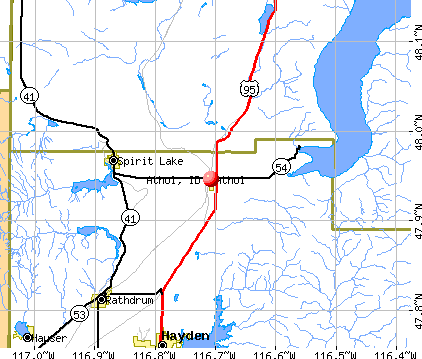
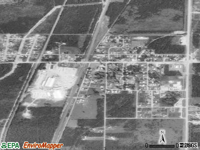
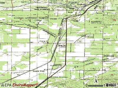
Athol, Idaho
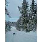
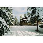
Athol: ranch outside downtown winter
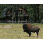
Athol: A Home where the Buffalow roam
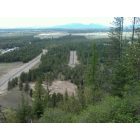
Athol: East Athol, looking east at a log home
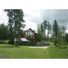
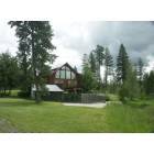
Athol: Corbin Hill Estates
Athol: Corbin Hill Estates
Athol: East Athol, looking east at a log home
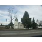
Athol: Church downtown Athol
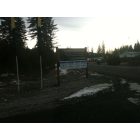
Athol: ranch outside downtown
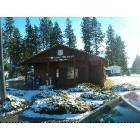
Athol: A winter wonderland
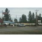
Athol: Downtown Athol, Pastime Club & American Legion Hall
Athol: athol post office
- add
your
Submit your own pictures of this city and show them to the world
- OSM Map
- General Map
- Google Map
- MSN Map
Population change since 2000: +8.3%
 |
| Males: 360 | |
| Females: 372 |
| Median resident age: | 43.1 years |
| Idaho median age: | 37.5 years |
Zip codes: 83801.
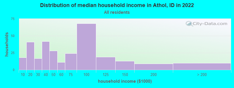
| Athol: | $50,778 |
| ID: | $72,785 |
Estimated per capita income in 2022: $25,856 (it was $13,632 in 2000)
Athol city income, earnings, and wages data
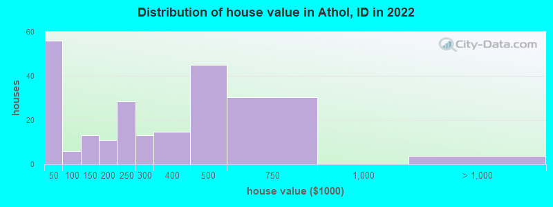
Estimated median house or condo value in 2022: $312,798 (it was $80,800 in 2000)
| Athol: | $312,798 |
| ID: | $432,500 |
Mean prices in 2022: all housing units: $279,719; detached houses: $337,150; mobile homes: $91,670; occupied boats, rvs, vans, etc.: $266,886
Median gross rent in 2022: $1,029.
Detailed information about poverty and poor residents in Athol, ID
Compare current foreclosures near Athol, ID:
| Photo | Address | Area | Beds / Baths | Price | Details |
|---|---|---|---|---|---|

|
#1
N Alice Ct
Athol, ID 83801
|
1,143 sq. feet
|
2 baths 3 beds |
show details | |

|
#2
N Alice Ct
Athol, ID 83801
|
900 sq. feet
|
3 baths 5 beds |
show details | |

|
#3
N Corbin Hill Rd
Athol, ID 83801
|
- sq. feet
|
- baths - beds |
show details | |

|
#4
Rock Springs Rd
Athol, ID 83801
|
- sq. feet
|
- baths - beds |
show details | |

|
#5
E Howard Rd
Athol, ID 83801
|
- sq. feet
|
- baths - beds |
show details | |

|
#6
N 4th St
Athol, ID 83801
|
- sq. feet
|
- baths - beds |
show details | |

|
#7
W Blackwell Blvd
Spirit Lake, ID 83869
|
1,200 sq. feet
|
2 baths 3 beds |
show details | |

|
#8
Hummingbird Ave
Blanchard, ID 83804
|
- sq. feet
|
2 baths 3 beds |
show details | |

|
#9
W California St
Rathdrum, ID 83858
|
1,200 sq. feet
|
2 baths 3 beds |
show details | |

|
#10
Psalms Way
Cocolalla, ID 83813
|
2,816 sq. feet
|
3 baths 4 beds |
show details |
| Photo | Address | Area | Beds / Baths | Price | Details |
|---|---|---|---|---|---|

|
#11
W Grenoble Ln
Coeur D Alene, ID 83815
|
1,031 sq. feet
|
2 baths 3 beds |
show details | |

|
#12
Bourbon Dr
Coeur D Alene, ID 83815
|
1,122 sq. feet
|
1 baths 2 beds |
show details | |

|
#13
E Brooklyn Ave
Coeur D Alene, ID 83815
|
1,380 sq. feet
|
3 baths 4 beds |
show details | |

|
#14
N Camp Ct
Hayden, ID 83835
|
1,102 sq. feet
|
2 baths 3 beds |
show details | |

|
#15
N Toulon Dr
Coeur D Alene, ID 83815
|
1,592 sq. feet
|
3 baths 4 beds |
show details | |

|
#16
Vay Rd
Priest River, ID 83856
|
803 sq. feet
|
1 baths 1 beds |
show details | |

|
#17
W Hampson Ave
Coeur D Alene, ID 83815
|
1,250 sq. feet
|
2 baths 3 beds |
show details | |

|
#18
Lotze Loop
Coeur D Alene, ID 83815
|
2,100 sq. feet
|
3 baths 4 beds |
show details | |

|
#19
E Berrywood St
Coeur D Alene, ID 83815
|
1,146 sq. feet
|
3 baths 4 beds |
show details | |

|
#20
N Lauren Loop
Rathdrum, ID 83858
|
1,406 sq. feet
|
2 baths 4 beds |
show details |
| Photo | Address | Area | Beds / Baths | Price | Details |
|---|---|---|---|---|---|

|
#21
N Stinson Loop
Hayden, ID 83835
|
944 sq. feet
|
1 baths 2 beds |
show details | |

|
#22
N Rude St
Hayden, ID 83835
|
1,372 sq. feet
|
2 baths 3 beds |
show details | |

|
#23
W Ashland Ln
Hayden, ID 83835
|
1,231 sq. feet
|
2 baths 2 beds |
show details | |

|
#24
N Ramsgate Ln
Hayden, ID 83835
|
2,210 sq. feet
|
2 baths 3 beds |
show details | |

|
#25
Dufort Rd
Sagle, ID 83860
|
3,032 sq. feet
|
1 baths 3 beds |
show details | |

|
#26
Calamonte Ln
Coeur D Alene, ID 83815
|
1,219 sq. feet
|
2 baths 3 beds |
show details | |

|
#27
W Tanager Ave
Hayden, ID 83835
|
1,228 sq. feet
|
2 baths 3 beds |
show details | |

|
#28
W Thorndale Loop
Coeur D Alene, ID 83815
|
1,528 sq. feet
|
2 baths 4 beds |
show details | |

|
#29
W Apperson Dr
Coeur D Alene, ID 83815
|
938 sq. feet
|
2 baths 4 beds |
show details | |

|
#30
W Macaw Ln
Rathdrum, ID 83858
|
1,180 sq. feet
|
2 baths 3 beds |
show details |
| Photo | Address | Area | Beds / Baths | Price | Details |
|---|---|---|---|---|---|

|
#31
N Lachaise Ln
Coeur D Alene, ID 83815
|
1,171 sq. feet
|
3 baths 4 beds |
show details | |

|
#32
W Sarge Ct
Coeur D Alene, ID 83815
|
926 sq. feet
|
2 baths 4 beds |
show details | |

|
#33
W Legacy Dr
Rathdrum, ID 83858
|
1,248 sq. feet
|
2 baths 3 beds |
show details | |

|
#34
W Rocky Rd
Rathdrum, ID 83858
|
1,680 sq. feet
|
2 baths 4 beds |
show details | |

|
#35
W Coeur Dalene Dr
Spirit Lake, ID 83869
|
1,971 sq. feet
|
3 baths 4 beds |
show details | |

|
#36
N 9th St
Coeur D Alene, ID 83815
|
1,402 sq. feet
|
3 baths 4 beds |
show details | |

|
#37
N 10th Pl
Coeur D Alene, ID 83815
|
1,094 sq. feet
|
1 baths 3 beds |
show details | |

|
#38
N Corvette Ct
Spirit Lake, ID 83869
|
1,040 sq. feet
|
2 baths 3 beds |
show details | |

|
#39
E Shadow Wood Ln
Coeur D Alene, ID 83815
|
1,516 sq. feet
|
2 baths 3 beds |
show details | |

|
#40
N Staples Ave
Coeur D Alene, ID 83815
|
1,144 sq. feet
|
1 baths 3 beds |
show details |
| Photo | Address | Area | Beds / Baths | Price | Details |
|---|---|---|---|---|---|

|
#41
W Kamloops Dr
Rathdrum, ID 83858
|
952 sq. feet
|
1 baths 3 beds |
show details | |

|
#42
Estates Loop
Priest River, ID 83856
|
1,140 sq. feet
|
2 baths 4 beds |
show details | |

|
#43
W Tombstone St
Rathdrum, ID 83858
|
871 sq. feet
|
1 baths 2 beds |
show details | |

|
#44
N Emerald Dr
Hayden, ID 83835
|
2,020 sq. feet
|
3 baths 4 beds |
show details | |

|
#45
N Wright St
Rathdrum, ID 83858
|
1,256 sq. feet
|
2 baths 3 beds |
show details | |

|
#46
W Flagstaff St
Rathdrum, ID 83858
|
1,598 sq. feet
|
2 baths 4 beds |
show details | |

|
#47
N Hourglass Dr
Coeur D Alene, ID 83815
|
- sq. feet
|
- baths - beds |
show details | |

|
#48
N Wheatfield Dr
Coeur D Alene, ID 83815
|
- sq. feet
|
- baths - beds |
show details | |

|
#49
N Aldridge Dr
Coeur D Alene, ID 83815
|
- sq. feet
|
- baths - beds |
show details | |

|
Check over 1 million property listings on Foreclosure.com!
|
browse all offers | |||


- 65878.7%White alone
- 9711.6%Hispanic
- 445.3%American Indian alone
- 172.0%Two or more races
- 131.6%Asian alone
- 30.4%Native Hawaiian and Other
Pacific Islander alone
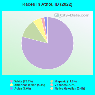
Races in Athol detailed stats: ancestries, foreign born residents, place of birth
According to our research of Idaho and other state lists, there were 23 registered sex offenders living in Athol, Idaho as of May 16, 2024.
The ratio of all residents to sex offenders in Athol is 39 to 1.
 Recent articles from our blog. Our writers, many of them Ph.D. graduates or candidates, create easy-to-read articles on a wide variety of topics.

 | Idaho is most moved destination 2 years in a row, will it change the state forever? (75 replies) |
| Coeur d’Alene vs. Hailey vs. Wallace (61 replies) |
| Relocating to Athol area (19 replies) |
| Road trip to Northern ID to find and buy a home next week. (69 replies) |
| Athol to Clark Fork via backroads (5 replies) |
| Teton Valley vs. CDA/Sandpoint for part time outdoorsman retirement (19 replies) |
Latest news from Athol, ID collected exclusively by city-data.com from local newspapers, TV, and radio stations
Ancestries: European (15.3%), American (14.7%), English (10.7%), German (8.8%), Norwegian (7.0%), Irish (4.8%).
Current Local Time: PST time zone
Elevation: 2391 feet
Land area: 0.79 square miles.
Population density: 929 people per square mile (low).
17 residents are foreign born (1.4% Asia, 0.4% Europe, 0.2% Latin America).
| This city: | 2.0% |
| Idaho: | 5.7% |
| Athol city: | 1.0% ($824) |
| Idaho: | 1.0% ($1,007) |
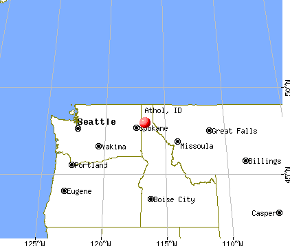
Nearest city with pop. 50,000+: Spokane Valley, WA (31.1 miles  , pop. 89,755).
Nearest city with pop. 200,000+: East Seattle, WA (254.7 miles , pop. 480,100).
Nearest city with pop. 1,000,000+: Los Angeles, CA (962.5 miles , pop. 3,694,820).
Nearest cities:
), ), Latitude: 47.95 N, Longitude: 116.71 W
Area code commonly used in this area: 208
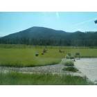
Athol tourist attractions:
| Here: | 4.2% |
| Idaho: | 3.1% |
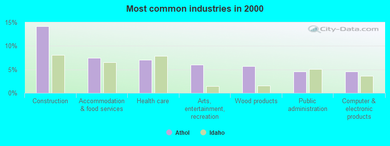
- Construction (14.1%)
- Accommodation & food services (7.4%)
- Health care (7.1%)
- Arts, entertainment, recreation (6.0%)
- Wood products (5.7%)
- Public administration (4.6%)
- Computer & electronic products (4.6%)
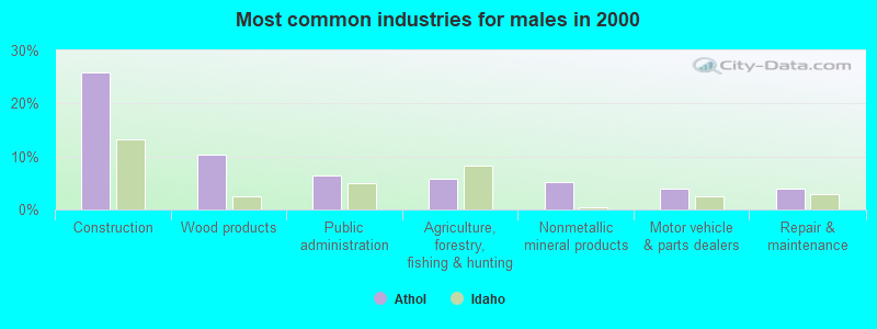
- Construction (25.8%)
- Wood products (10.3%)
- Public administration (6.5%)
- Agriculture, forestry, fishing & hunting (5.8%)
- Nonmetallic mineral products (5.2%)
- Motor vehicle & parts dealers (3.9%)
- Repair & maintenance (3.9%)
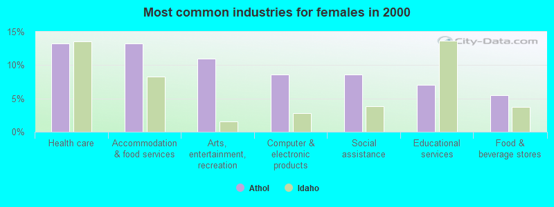
- Health care (13.3%)
- Accommodation & food services (13.3%)
- Arts, entertainment, recreation (10.9%)
- Computer & electronic products (8.6%)
- Social assistance (8.6%)
- Educational services (7.0%)
- Food & beverage stores (5.5%)
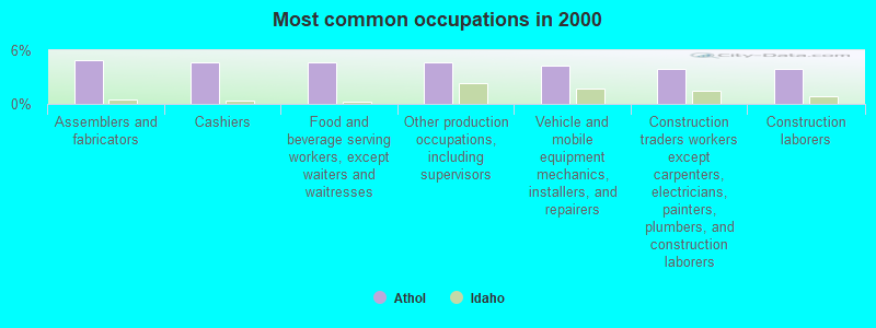
- Assemblers and fabricators (4.9%)
- Cashiers (4.6%)
- Food and beverage serving workers, except waiters and waitresses (4.6%)
- Other production occupations, including supervisors (4.6%)
- Vehicle and mobile equipment mechanics, installers, and repairers (4.2%)
- Construction traders workers except carpenters, electricians, painters, plumbers, and construction laborers (3.9%)
- Construction laborers (3.9%)
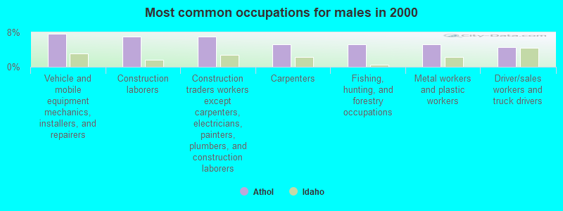
- Vehicle and mobile equipment mechanics, installers, and repairers (7.7%)
- Construction laborers (7.1%)
- Construction traders workers except carpenters, electricians, painters, plumbers, and construction laborers (7.1%)
- Carpenters (5.2%)
- Fishing, hunting, and forestry occupations (5.2%)
- Metal workers and plastic workers (5.2%)
- Driver/sales workers and truck drivers (4.5%)
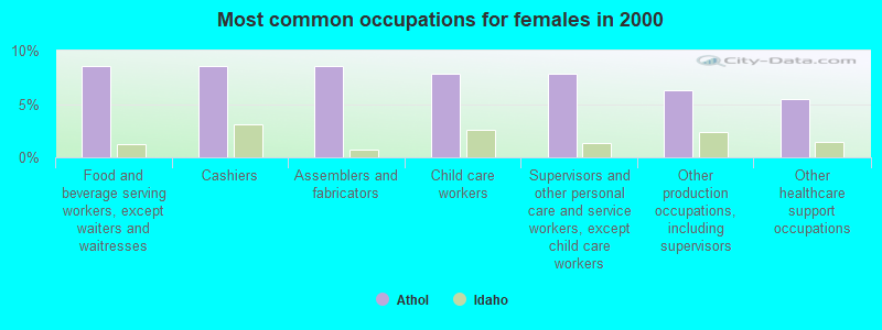
- Food and beverage serving workers, except waiters and waitresses (8.6%)
- Cashiers (8.6%)
- Assemblers and fabricators (8.6%)
- Child care workers (7.8%)
- Supervisors and other personal care and service workers, except child care workers (7.8%)
- Other production occupations, including supervisors (6.2%)
- Other healthcare support occupations (5.5%)
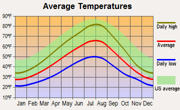
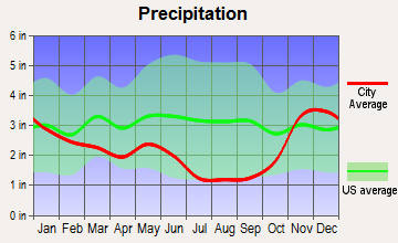
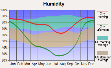
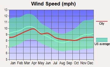
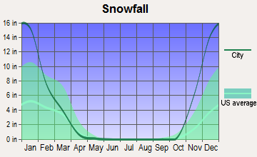
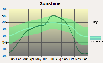
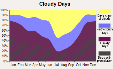
Average climate in Athol, Idaho
Based on data reported by over 4,000 weather stations
(lower is better)
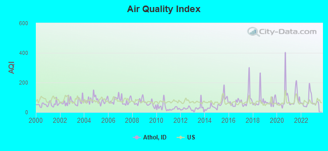
Air Quality Index (AQI) level in 2022 was 77.5. This is about average.
| City: | 77.5 |
| U.S.: | 72.6 |
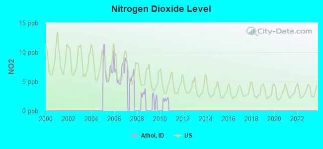
Nitrogen Dioxide (NO2) [ppb] level in 2007 was 6.56. This is worse than average. Closest monitor was 11.8 miles away from the city center.
| City: | 6.56 |
| U.S.: | 5.11 |
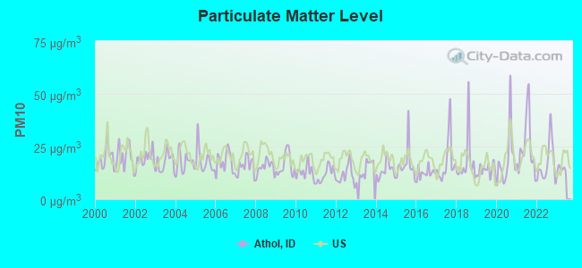
Particulate Matter (PM10) [µg/m3] level in 2022 was 17.1. This is about average. Closest monitor was 10.7 miles away from the city center.
| City: | 17.1 |
| U.S.: | 19.2 |
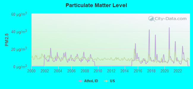
Particulate Matter (PM2.5) [µg/m3] level in 2022 was 8.20. This is about average. Closest monitor was 18.4 miles away from the city center.
| City: | 8.20 |
| U.S.: | 8.11 |
Earthquake activity:
Athol-area historical earthquake activity is significantly above Idaho state average. It is 885% greater than the overall U.S. average.On 8/18/1959 at 06:37:13, a magnitude 7.7 (7.7 UK, Class: Major, Intensity: VIII - XII) earthquake occurred 371.9 miles away from the city center, causing $26,000,000 total damage
On 10/28/1983 at 14:06:06, a magnitude 7.3 (6.2 MB, 7.3 MS, 7.0 MW) earthquake occurred 301.8 miles away from Athol center, causing 2 deaths (2 shaking deaths) and 3 injuries, causing $15,000,000 total damage
On 4/13/1949 at 19:55:42, a magnitude 7.0 (7.0 UK) earthquake occurred 274.4 miles away from the city center, causing $80,000,000 total damage
On 2/28/2001 at 18:54:32, a magnitude 6.8 (6.5 MB, 6.6 MS, 6.8 MW, Class: Strong, Intensity: VII - IX) earthquake occurred 280.6 miles away from the city center, causing $2,000,000,000 total damage and $305,000,000 insured losses
On 2/28/2001 at 18:54:32, a magnitude 6.8 (6.8 MD, Depth: 32.2 mi) earthquake occurred 286.3 miles away from Athol center
On 4/29/1965 at 15:28:43, a magnitude 6.6 (6.6 UK) earthquake occurred 265.7 miles away from the city center, causing $28,000,000 total damage
Magnitude types: body-wave magnitude (MB), duration magnitude (MD), surface-wave magnitude (MS), moment magnitude (MW)
Natural disasters:
The number of natural disasters in Kootenai County (13) is near the US average (15).Major Disasters (Presidential) Declared: 10
Emergencies Declared: 1
Causes of natural disasters: Floods: 7, Storms: 5, Fire: 1, Heavy Rain: 1, Hurricane: 1, Landslide: 1, Mudslide: 1, Snow: 1, Volcanic Eruption: 1, Wind: 1, Winter Storm: 1, Other: 1 (Note: some incidents may be assigned to more than one category).
Hospitals and medical centers near Athol:
- HOSPICE OF NORTH IDAHO (Hospital, about 14 miles away; HAYDEN, ID)
- APPLEGATE HOSPICE (Hospital, about 15 miles away; HAYDEN, ID)
- LIFE CARE CENTER OF COEUR D'ALENE (Nursing Home, about 15 miles away; COEUR D ALENE, ID)
- PANHANDLE HEALTH DISTRICT (Home Health Center, about 15 miles away; HAYDEN, ID)
- FMC HAYDEN LAKE (Dialysis Facility, about 15 miles away; COEUR D'ALENE, ID)
Airports located in Athol:
- Hackney Airpark Airport (ID05) (Runways: 1, Itinerant Ops: 1,000, Local Ops: 3,000)
- Granite Airport (ID34) (Runways: 1)
- Western Spur Airport (ID48) (Runways: 1)
Colleges/universities with over 2000 students nearest to Athol:
- North Idaho College (about 20 miles; Coeur d'Alene, ID; Full-time enrollment: 4,684)
- Whitworth University (about 36 miles; Spokane, WA; FT enrollment: 2,689)
- Spokane Community College (about 36 miles; Spokane, WA; FT enrollment: 6,482)
- Gonzaga University (about 38 miles; Spokane, WA; FT enrollment: 6,780)
- Spokane Falls Community College (about 40 miles; Spokane, WA; FT enrollment: 6,052)
- Eastern Washington University (about 52 miles; Cheney, WA; FT enrollment: 11,643)
- University of Idaho (about 86 miles; Moscow, ID; FT enrollment: 10,416)
Public elementary/middle school in Athol:
- ATHOL ELEMENTARY SCHOOL (Students: 386, Location: 6333 E MENSER AVE, Grades: PK-6)
Points of interest:
Notable location: Timberlake Fire Protection District Station 1 (A). Display/hide its location on the map
Tourist attraction: Silverwood Theme & RV Park (Water Parks & Slides; 27843 North Highway 95).
Hotels: Athol Motel (5950 East Highway 54), Monte's Mountain Ranch & Lodge (24279 N V Lazy S Ln).
Drinking water stations with addresses in Athol and their reported violations in the past:
ATHOL CITY OF (Population served: 725, Groundwater):Past monitoring violations:PINEVIEW ESTATES WATER DIST (Population served: 450, Groundwater):
- One routine major monitoring violation
- One regular monitoring violation
Past health violations:HACKNEY WATER AND SEWER DIST (Population served: 167, Groundwater):
- MCL, Monthly (TCR) - In DEC-2007, Contaminant: Coliform
- MCL, Monthly (TCR) - In NOV-2007, Contaminant: Coliform
Past health violations:LITTLE BLACKTAIL RANCH WATER DISTRICT (Population served: 89, Surface water):
- MCL, Monthly (TCR) - In SEP-2008, Contaminant: Coliform
Past health violations:MOUNTAIN VIEW PARK (Population served: 75, Groundwater):Past monitoring violations:
- Treatment Technique (SWTR and GWR) - In DEC-2005
- Monitoring of Treatment (SWTR-Filter) - In JAN-2014
- Monitoring of Treatment (SWTR-Filter) - In NOV-2013
- Monitoring of Treatment (SWTR-Filter) - In DEC-2012
- Monitoring, Turbidity (Enhanced SWTR) - In JAN-2011, Contaminant: IESWTR
- Monitoring and Reporting (DBP) - Between JUL-2005 and SEP-2005, Contaminant: Chlorine. Follow-up actions: St Compliance achieved (MAR-09-2007)
- One routine major monitoring violation
- 2 other older monitoring violations
Past health violations:EIGHT MILE PRAIRIE (Population served: 55, Groundwater):
- MCL, Monthly (TCR) - In JUN-2014, Contaminant: Coliform. Follow-up actions: St Public Notif requested (JUN-24-2014), St Public Notif received (JUN-24-2014)
- MCL, Monthly (TCR) - In JAN-2008, Contaminant: Coliform
Past health violations:BERRY PATCH WATER ACRES ASSN (Population served: 45, Groundwater):Past monitoring violations:
- MCL, Monthly (TCR) - In SEP-2012, Contaminant: Coliform. Follow-up actions: St Public Notif received (JUL-31-2012), St Violation/Reminder Notice (NOV-01-2012), St Public Notif requested (NOV-04-2012)
- MCL, Monthly (TCR) - In AUG-2012, Contaminant: Coliform. Follow-up actions: St Public Notif received (JUL-31-2012), St Violation/Reminder Notice (OCT-01-2012), St Public Notif requested (OCT-04-2012)
- MCL, Monthly (TCR) - In JUL-2012, Contaminant: Coliform. Follow-up actions: St Public Notif received (JUL-31-2012), St Violation/Reminder Notice (OCT-01-2012), St Public Notif requested (OCT-04-2012)
- MCL, Monthly (TCR) - In JUN-2012, Contaminant: Coliform. Follow-up actions: St Public Notif received (JUN-23-2012), St Violation/Reminder Notice (JUL-02-2012), St Public Notif requested (JUL-05-2012)
- MCL, Monthly (TCR) - In DEC-2011, Contaminant: Coliform. Follow-up actions: St Violation/Reminder Notice (MAR-01-2012), St Public Notif requested (MAR-04-2012)
- MCL, Monthly (TCR) - In OCT-2011, Contaminant: Coliform. Follow-up actions: St Violation/Reminder Notice (OCT-31-2011), St Public Notif requested (NOV-03-2011)
- 6 other older health violations
- Monitoring, Repeat Major (TCR) - In DEC-2012, Contaminant: Coliform (TCR)
- Monitoring, Repeat Major (TCR) - In OCT-2012, Contaminant: Coliform (TCR)
Past health violations:LYNNWOOD ESTATES (Population served: 43, Groundwater):Past monitoring violations:
- MCL, Monthly (TCR) - In AUG-2010, Contaminant: Coliform. Follow-up actions: St Violation/Reminder Notice (OCT-01-2010), St Public Notif requested (OCT-04-2010), St Public Notif received (OCT-14-2010)
- MCL, Monthly (TCR) - In MAY-2005, Contaminant: Coliform
- 2 routine major monitoring violations
Past health violations:
- MCL, Average - In SEP-2013, Contaminant: Arsenic. Follow-up actions: St Public Notif received (SEP-24-2013), St Violation/Reminder Notice (NOV-04-2013), St Public Notif requested (NOV-07-2013), St Compliance achieved (NOV-29-2013)
- MCL, Average - In AUG-2013, Contaminant: Arsenic. Follow-up actions: St Public Notif received (SEP-24-2013), St Violation/Reminder Notice (NOV-04-2013), St Public Notif requested (NOV-07-2013), St Compliance achieved (NOV-29-2013)
- MCL, Average - In JUL-2013, Contaminant: Arsenic. Follow-up actions: St Public Notif received (SEP-24-2013), St Violation/Reminder Notice (NOV-04-2013), St Public Notif requested (NOV-07-2013), St Compliance achieved (NOV-29-2013)
- MCL, Average - Between APR-2013 and JUN-2013, Contaminant: Arsenic. Follow-up actions: St Violation/Reminder Notice (JUN-03-2013), St Public Notif requested (JUN-06-2013), St Public Notif received (JUN-25-2013), St Compliance achieved (NOV-29-2013)
- MCL, Average - Between JAN-2013 and MAR-2013, Contaminant: Arsenic. Follow-up actions: St Violation/Reminder Notice (FEB-01-2013), St Public Notif requested (FEB-04-2013), St Public Notif received (MAY-20-2013), St Compliance achieved (NOV-29-2013)
- MCL, Average - Between OCT-2012 and DEC-2012, Contaminant: Arsenic. Follow-up actions: St Violation/Reminder Notice (DEC-03-2012), St Public Notif requested (DEC-06-2012), St Public Notif received (MAY-03-2013), St Compliance achieved (NOV-29-2013)
- 10 other older health violations
Drinking water stations with addresses in Athol that have no violations reported:
- FARRAGUT VILLAGE PROPERTY ASSN INC (Population served: 133, Primary Water Source Type: Groundwater)
- HIGHWAY 54 WATER DIST (Population served: 84, Primary Water Source Type: Groundwater)
- MALABAR MOBILE HOME PARK (Population served: 60, Primary Water Source Type: Groundwater)
- FLYING W RANCH (Population served: 27, Primary Water Source Type: Groundwater)
| This city: | 2.5 people |
| Idaho: | 2.7 people |
| This city: | 62.4% |
| Whole state: | 69.6% |
| This city: | 10.3% |
| Whole state: | 6.3% |
Likely homosexual households (counted as self-reported same-sex unmarried-partner households)
- Lesbian couples: 0.4% of all households
- Gay men: 0.0% of all households
For population 15 years and over in Athol:
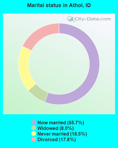
- Never married: 18.5%
- Now married: 55.7%
- Separated: 0.0%
- Widowed: 8.0%
- Divorced: 17.8%
For population 25 years and over in Athol:
- High school or higher: 88.1%
- Bachelor's degree or higher: 11.2%
- Graduate or professional degree: 4.0%
- Unemployed: 5.7%
- Mean travel time to work (commute): 37.2 minutes
| Here: | 8.5 |
| Idaho average: | 11.0 |


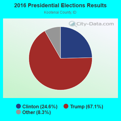

Graphs represent county-level data. Detailed 2008 Election Results
Religion statistics for Athol, ID (based on Kootenai County data)
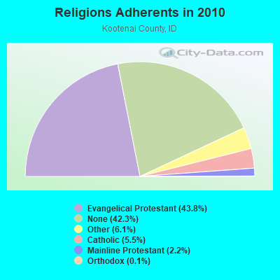
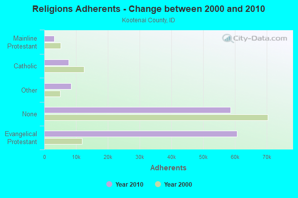
| Religion | Adherents | Congregations |
|---|---|---|
| Evangelical Protestant | 60,657 | 77 |
| Other | 8,492 | 24 |
| Catholic | 7,597 | 8 |
| Mainline Protestant | 3,064 | 13 |
| Orthodox | 162 | 1 |
| None | 58,522 | - |
Food Environment Statistics:
| Kootenai County: | 1.42 / 10,000 pop. |
| Idaho: | 1.88 / 10,000 pop. |
| This county: | 0.22 / 10,000 pop. |
| State: | 0.28 / 10,000 pop. |
| Kootenai County: | 0.89 / 10,000 pop. |
| Idaho: | 0.53 / 10,000 pop. |
| Kootenai County: | 3.20 / 10,000 pop. |
| State: | 3.87 / 10,000 pop. |
| Here: | 8.64 / 10,000 pop. |
| State: | 7.75 / 10,000 pop. |
| This county: | 8.0% |
| Idaho: | 7.7% |
| Kootenai County: | 24.0% |
| Idaho: | 25.7% |
| This county: | 7.1% |
| State: | 11.7% |
Health and Nutrition:
| Athol: | 44.3% |
| Idaho: | 48.7% |
| Here: | 34.3% |
| Idaho: | 45.7% |
| Here: | 27.8 |
| Idaho: | 28.6 |
| This city: | 17.8% |
| State: | 21.8% |
| This city: | 5.9% |
| Idaho: | 10.0% |
| Athol: | 6.7 |
| State: | 6.8 |
| Athol: | 27.9% |
| Idaho: | 33.4% |
| This city: | 49.7% |
| State: | 56.0% |
| Athol: | 73.0% |
| Idaho: | 78.5% |
More about Health and Nutrition of Athol, ID Residents
| Local government employment and payroll (March 2022) | |||||
| Function | Full-time employees | Monthly full-time payroll | Average yearly full-time wage | Part-time employees | Monthly part-time payroll |
|---|---|---|---|---|---|
| Other Government Administration | 9 | $15,690 | $20,920 | 0 | $0 |
| Totals for Government | 9 | $15,690 | $20,920 | 0 | $0 |
Athol government finances - Expenditure in 2017 (per resident):
- Current Operations - General - Other: $217,000 ($296.45)
Local Fire Protection: $217,000 ($296.45)
Sewerage: $187,000 ($255.46)
Regular Highways: $138,000 ($188.52)
Solid Waste Management: $137,000 ($187.16)
Water Utilities: $93,000 ($127.05)
Police Protection: $51,000 ($69.67)
Parks and Recreation: $44,000 ($60.11)
Air Transportation: $23,000 ($31.42)
Miscellaneous Commercial Activities - Other: $12,000 ($16.39)
- Other Capital Outlay - Local Fire Protection: $263,000 ($359.29)
Regular Highways: $116,000 ($158.47)
Sewerage: $39,000 ($53.28)
Miscellaneous Commercial Activities - Other: $36,000 ($49.18)
Water Utilities: $24,000 ($32.79)
Air Transportation: $14,000 ($19.13)
General - Other: $11,000 ($15.03)
Parks and Recreation: $9,000 ($12.30)
- Total Salaries and Wages: $178,000 ($243.17)
Athol government finances - Revenue in 2017 (per resident):
- Charges - Sewerage: $179,000 ($244.54)
Solid Waste Management: $134,000 ($183.06)
Regular Highways: $50,000 ($68.31)
Miscellaneous Commercial Activities: $2,000 ($2.73)
- Miscellaneous - Rents: $48,000 ($65.57)
General Revenue - Other: $12,000 ($16.39)
Interest Earnings: $6,000 ($8.20)
Sale of Property: $3,000 ($4.10)
Donations From Private Sources: $2,000 ($2.73)
- Revenue - Water Utilities: $77,000 ($105.19)
- State Intergovernmental - Sewerage: $60,000 ($81.97)
General Local Government Support: $45,000 ($61.48)
- Tax - Property: $348,000 ($475.41)
General Sales and Gross Receipts: $6,000 ($8.20)
Occupation and Business License - Other: $6,000 ($8.20)
Alcoholic Beverage License: $2,000 ($2.73)
Other License: $2,000 ($2.73)
Athol government finances - Cash and Securities in 2017 (per resident):
- Other Funds - Cash and Securities: $476,000 ($650.27)
Businesses in Athol, ID
- U-Haul: 1
- UPS: 1
Strongest AM radio stations in Athol:
- KVNI (1080 AM; 10 kW; COEUR D' ALENE, ID; Owner: QUEENB RADIO, INC.)
- KGA (1510 AM; 50 kW; SPOKANE, WA; Owner: CITADEL BROADCASTING COMPANY)
- KXLY (920 AM; 20 kW; SPOKANE, WA; Owner: SPOKANE RADIO, INC.)
- KMJY (700 AM; 10 kW; NEWPORT, WA; Owner: JAMES E. AND HELEN G. STARGEL)
- KQNT (590 AM; 5 kW; SPOKANE, WA; Owner: CAPSTAR TX LIMITED PARTNERSHIP)
- KERR (750 AM; 50 kW; POLSON, MT; Owner: ANDERSON RADIO BROADCASTING, INC.)
- KJRB (790 AM; 5 kW; SPOKANE, WA; Owner: CITADEL BROADCASTING COMPANY)
- KTRW (970 AM; 5 kW; SPOKANE, WA; Owner: KTRW, LLC)
- KTBI (810 AM; daytime; 50 kW; EPHRATA, WA; Owner: TACOMA BROADCASTERS, INCORPORATED)
- KOFI (1180 AM; 50 kW; KALISPELL, MT; Owner: KOFI, INC.)
- KDRK (1050 AM; 5 kW; DISHMAN, WA; Owner: CITADEL BROADCASTING COMPANY)
- KQQQ (1150 AM; 25 kW; PULLMAN, WA; Owner: RADIO PALOUSE, INC.)
- KAQQ (1280 AM; 5 kW; SPOKANE, WA)
Strongest FM radio stations in Athol:
- KHTQ (94.5 FM; HAYDEN, ID; Owner: QUEENB RADIO, INC.)
- KXLY-FM (99.9 FM; SPOKANE, WA; Owner: SPOKANE RADIO, INC.)
- KCDA (103.1 FM; POST FALLS, ID; Owner: CAPSTAR TX LIMITED PARTNERSHIP)
- KICR (102.3 FM; COEUR D'ALENE, ID; Owner: GREAT NORTHERN BROADCASTING, INC.)
- KPND (95.3 FM; SANDPOINT, ID; Owner: BLUE SKY BROADCASTING INC.)
- KDRK-FM (93.7 FM; SPOKANE, WA; Owner: CITADEL BROADCASTING COMPANY)
- KIXZ-FM (96.1 FM; OPPORTUNITY, WA; Owner: CAPSTAR TX LIMITED PARTNERSHIP)
- KMBI-FM (107.9 FM; SPOKANE, WA; Owner: THE MOODY BIBLE INSTITUTE OF CHICAGO)
- KPBX-FM (91.1 FM; SPOKANE, WA; Owner: SPOKANE PUBLIC RADIO, INC.)
- KMJY-FM (104.5 FM; NEWPORT, WA; Owner: ALC COMMUNICATIONS)
- KZZU-FM (92.9 FM; SPOKANE, WA; Owner: QUEENB)
- KISC (98.1 FM; SPOKANE, WA; Owner: CAPSTAR TX LIMITED PARTNERSHIP)
- KEYF-FM (101.1 FM; CHENEY, WA; Owner: CITADEL BROADCASTING COMPANY)
- KZBD (105.7 FM; SPOKANE, WA; Owner: CITADEL BROADCASTING COMPANY)
- KIBX (92.1 FM; BONNERS FERRY, ID; Owner: SPOKANE PUBLIC RADIO, INC.)
- KKZX (98.9 FM; SPOKANE, WA; Owner: CAPSTAR TX LIMITED PARTNERSHIP)
- KSFC (91.9 FM; SPOKANE, WA; Owner: SPOKANE PUBLIC RADIO)
- KTWD (97.5 FM; WALLACE, ID; Owner: CSN INTERNATIONAL)
- KEEH (104.9 FM; SPOKANE, WA; Owner: UPPER COLUMBIA MEDIA ASSOCIATION)
- KAGU (88.7 FM; SPOKANE, WA; Owner: GONZAGA UNIVERSITY TELECOMMUNICATIONS ASSOCIATION)
TV broadcast stations around Athol:
- K59BW (Channel 59; BONNERS FERRY, ID; Owner: STATE BOARD OF EDUCATION (IEPBS))
- KREM-TV (Channel 2; SPOKANE, WA; Owner: KING BROADCASTING COMPANY)
- KHQ-TV (Channel 6; SPOKANE, WA; Owner: KHQ, INCORPORATED)
- KAYU-TV (Channel 28; SPOKANE, WA; Owner: MOUNTAIN LICENSES, L.P.)
Athol fatal accident list:
Sep 12, 2015 03:49 AM, Us-95, Lat: 47.934925, Lon: -116.699017, Vehicles: 2, Persons: 4, Fatalities: 3, Drunk persons involved: 1
Nov 10, 2007 00:53 AM, Sarah Loop, Lat: 47.928353, Lon: -116.731589, Vehicles: 1, Persons: 1, Fatalities: 1, Drunk persons involved: 1
Jul 2, 2002 04:03 PM, Us-95, Vehicles: 1, Persons: 1, Fatalities: 1
Aug 11, 1987 08:00 AM, 001540, Vehicles: 2, Persons: 3, Fatalities: 1
Sep 4, 1983 01:30 AM, 001640, Vehicles: 1, Persons: 2, Fatalities: 1, Drunk persons involved: 1
Aug 31, 1980 07:37 PM, Vehicles: 2, Persons: 8, Fatalities: 1, Drunk persons involved: 1
- National Bridge Inventory (NBI) Statistics
- 17Number of bridges
- 161ft / 48.7mTotal length
- $5,891,000Total costs
- 73,570Total average daily traffic
- 7,656Total average daily truck traffic
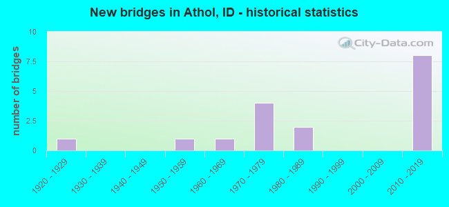
- New bridges - historical statistics
- 11920-1929
- 11950-1959
- 11960-1969
- 41970-1979
- 21980-1989
- 82010-2019
FCC Registered Broadcast Land Mobile Towers: 10 (See the full list of FCC Registered Broadcast Land Mobile Towers in Athol, ID)
FCC Registered Microwave Towers: 37 (See the full list of FCC Registered Microwave Towers in this town)
FCC Registered Amateur Radio Licenses: 207 (See the full list of FCC Registered Amateur Radio Licenses in Athol)
FAA Registered Aircraft Manufacturers and Dealers: 2 (See the full list of FAA Registered Manufacturers and Dealers in Athol)
FAA Registered Aircraft: 37 (See the full list of FAA Registered Aircraft)
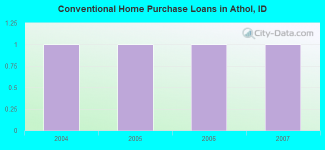
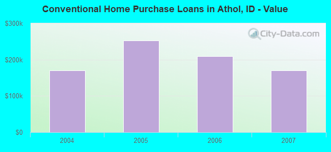
| Home Mortgage Disclosure Act Aggregated Statistics For Year 2009 (Based on 1 partial tract) | ||
| C) Refinancings | ||
|---|---|---|
| Number | Average Value | |
| LOANS ORIGINATED | 2 | $185,840 |
| APPLICATIONS APPROVED, NOT ACCEPTED | 0 | $0 |
| APPLICATIONS DENIED | 1 | $134,410 |
| APPLICATIONS WITHDRAWN | 0 | $0 |
| FILES CLOSED FOR INCOMPLETENESS | 0 | $0 |
Detailed HMDA statistics for the following Tracts: 0002.00
2002 - 2018 National Fire Incident Reporting System (NFIRS) incidents
- Fire incident types reported to NFIRS in Athol, ID
- 36844.9%Outside Fires
- 31638.6%Structure Fires
- 8710.6%Mobile Property/Vehicle Fires
- 485.9%Other
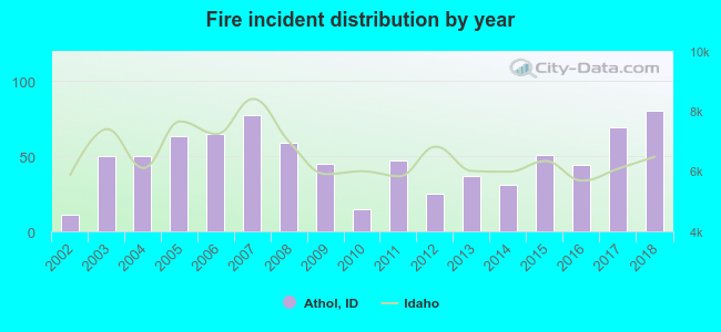 According to the data from the years 2002 - 2018 the average number of fire incidents per year is 48. The highest number of fire incidents - 80 took place in 2018, and the least - 11 in 2002. The data has an increasing trend.
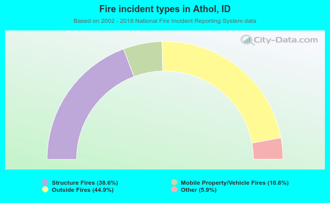 When looking into fire subcategories, the most incidents belonged to: Outside Fires (44.9%), and Structure Fires (38.6%).
| Most common first names in Athol, ID among deceased individuals | ||
| Name | Count | Lived (average) |
|---|---|---|
| Robert | 19 | 70.0 years |
| John | 17 | 74.2 years |
| William | 14 | 74.0 years |
| Charles | 12 | 73.9 years |
| James | 8 | 68.1 years |
| Albert | 7 | 70.1 years |
| Clarence | 7 | 70.7 years |
| Donald | 7 | 67.4 years |
| Thomas | 6 | 73.5 years |
| Helen | 5 | 82.2 years |
| Most common last names in Athol, ID among deceased individuals | ||
| Last name | Count | Lived (average) |
|---|---|---|
| Johnson | 6 | 81.5 years |
| Ellis | 5 | 82.0 years |
| Stewart | 5 | 74.0 years |
| Brown | 4 | 66.8 years |
| Miller | 4 | 69.3 years |
| Taylor | 4 | 68.7 years |
| Smith | 4 | 76.0 years |
| Stone | 4 | 77.5 years |
| Hanson | 3 | 75.7 years |
| King | 3 | 72.7 years |
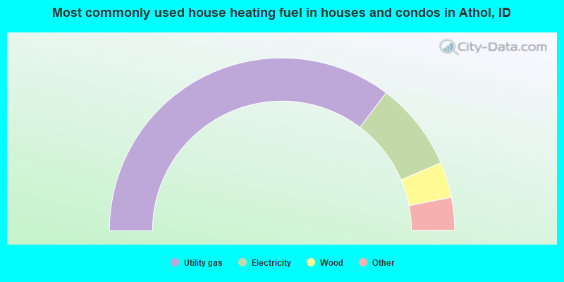
- 71.2%Utility gas
- 16.7%Electricity
- 6.7%Wood
- 2.9%Fuel oil, kerosene, etc.
- 2.5%Bottled, tank, or LP gas
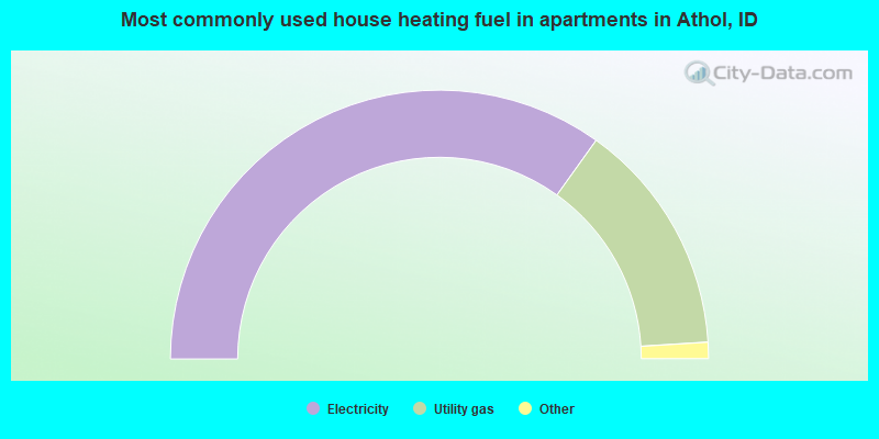
- 71.2%Electricity
- 28.8%Utility gas
Athol compared to Idaho state average:
- Unemployed percentage below state average.
- Black race population percentage significantly below state average.
- Foreign-born population percentage below state average.
- Length of stay since moving in significantly above state average.
- Number of college students below state average.
- Percentage of population with a bachelor's degree or higher below state average.

|
|
Total of 9 patent applications in 2008-2024.